

- Eras
- Indigenous eraEarly American eraLumbering eraModern era
- Concepts
- forestsvegetationtreeswildlifebirdsenvironmentgeologywetlandsconservationlumberingland-survey
- Within
- Beaver Island archipelago
Summary
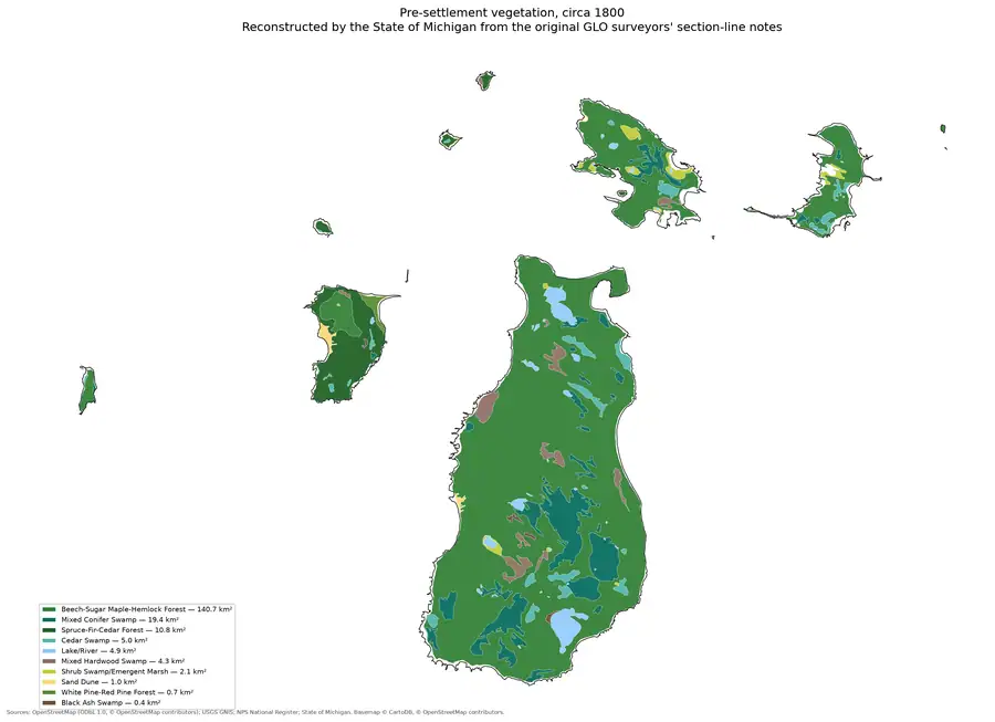
The archipelago’s tree history is visible at several incompatible scales. The 1849 GLO field notes record what surveyors saw in bounded portions of individual islands. The circa-1800 reconstruction generalizes surveyor notes into mapped cover classes. Historical accounts describe timber as fuel, tanbark, and lumber, while modern DNR inventories classify stands by forest type, age structure, and habitat-management goal. These sources complement one another but cannot be merged into a single species census.
The MNFI 1999 island inventory adds an important intermediate forest baseline. Its targeted natural-community work documented 18 new occurrences and one updated occurrence across Beaver, Garden, and Hog, including mesic and dry-mesic northern forest, boreal forest, forest dune/swale complex, hardwood swamp, northern fen, Great Lakes marsh, and northern wet meadow. Thirteen of the new occurrences, representing eight community types, were attributed to the Beaver Island archipelago. This is a record of concentrated survey effort, not a complete comparison of every island or forest stand.
The 2002 final synthesis shows how these occurrence records were intended to connect to maps. MNFI describes digitizing roughly 460 natural-feature occurrences into its GIS and then using those data to identify significant biodiversity areas. The project-wide totals—216 documented occurrences and 94 significant areas, including 40 in the Beaver Island archipelago—belong to the selected Great Lakes island groups and should not be mistaken for a Beaver-only forest count. They nevertheless provide historical precedent for joining GLO vegetation, circa-1800 cover, soils, current MiFI stands, canopy, and MNFI natural-community evidence while preserving each layer’s scale.
Planning-era forest synthesis
The Beaver Island planning natural-resource evidence crosswalk, 2017–2024 adds the 2017–2024 planning vocabulary between those resolutions. The plans name boreal, dry-mesic northern, mesic northern, northern-hardwood, lowland-deciduous, and lowland-coniferous forests, then list sugar maple, tamarack, black spruce, white cedar, red and white pine, balsam fir, and eastern hemlock. They also preserve old fields, pastures, clear-cuts, Emerald Ash Borer, and Beech Bark Disease as management context. These are useful dated syntheses, not a new stand map or complete tree census.
The companion Beaver Island Master Plan ecology map-plate evidence, 2017–2024 preserves the planning plates used alongside this vocabulary: soils, slope, elevation, wetlands, dunes, and inland waters. The current index intentionally does not treat the small Map 2.16 thumbnail as a digitized canopy raster. The page records a qualitative relative-density planning representation; the quantitative seven-island comparison remains the separate NLCD canopy layer.
The Seven-island ecology connectivity matrix, 2026 extends this forest evidence beyond the Beaver-centered public-stand frame. It keeps Fox and Whiskey as explicit rows with their canopy, soil, geology, and wildlife context, while showing that MNFI occurrence and DNR stand coverage is asymmetric rather than silently treating those islands as ecological blanks.
Seven-island forest evidence frame
The matrix makes that asymmetry measurable without pretending that the rows are equivalent inventories. The following forest-specific slice reports tree and woody-vegetation evidence matches, distinct source records, normalized labels, named MNFI natural-community occurrences, 2023 canopy summaries, and public MiFI stand polygons:1
| Island | Tree/woody evidence rows | Distinct source records | Tree/woody labels | MNFI occurrences | 2023 mean canopy | Public MiFI stands |
|---|---|---|---|---|---|---|
| Beaver Island | 1,634 | 361 | 43 | 17 | 65.50% | 424 |
| Garden Island | 88 | 18 | 27 | 12 | 59.97% | 0 |
| High Island | 51 | 8 | 17 | 8 | 70.56% | 0 |
| Hog Island | 48 | 9 | 18 | 6 | 60.82% | 0 |
| Whiskey Island | 4 | 1 | 4 | 0 | 39.99% | 0 |
| North Fox Island | 22 | 3 | 12 | 0 | 69.77% | 0 |
| South Fox Island | 4 | 1 | 4 | 0 | 64.43% | 0 |
These figures are not rankings of forest quality. Beaver’s tree rows combine 167 GLO field-note matches, 1,369 DNR stand-comment matches, and 98 MNFI occurrence matches;1 Garden, High, and Hog combine GLO and MNFI records; and Whiskey plus both Fox Islands are represented here by exact-island GLO rows. The zero MiFI values for the six non-Beaver rows are public-inventory query coverage results, not evidence that those islands lack forests. Likewise, a canopy percentage identifies remotely sensed tree cover at its stated pixel scale, not species, age, height, ownership, or a natural-community boundary. The exact-island join also leaves group labels such as “Garden and Hog Islands” unsplit when the source does not assign them separately.
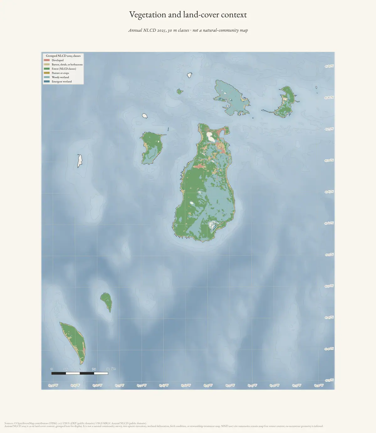
The NLCD tree-canopy percentage across the seven islands, 2021 and 2023 supplies 30 m canopy- percentage summaries for Beaver, Garden, High, Hog, Whiskey, North Fox, and South Fox Islands in 2021 and 2023. This is a useful connectivity bridge, but canopy percentage still does not identify tree species, stand age, tree height, or natural-community boundaries.
The High Island American woodcock habitat crosswalk adds a bird-centered forest-function lens to this tree history. Its secondary synthesis associates High Island woodcock with old fields, shrub and young-tree cover, second-growth hardwood and conifer forest, and changing moisture and disturbance conditions. That makes early-successional cover and forest edge legible alongside tree names, canopy, soils, and stand categories. The report is not a current occupancy record: the Whitcomb primary scan is not held, and the comparison does not assign woodcock to any mapped forest or soil polygon.
Species in the 1849 observations
| Surveyed place | Species and conditions recorded in the held source article |
|---|---|
| Garden Island | Cedar, white birch, fir, tamarack, spruce, aspen, spotted maple, sugar, ground hemlock, pale cedar, and dry beech; 1849 pages also record sandy/stony ground over compact beach-like stone, short shrub growth, windfall, fire, locally handsome sugar timber and a few good sugar bushes, plus maple, cottonwood, white pine, and hemlock. Pages 0117 and 0127 add stony third-rate ground, dead/fallen fire-affected timber, grass marsh, burned timber, windfall, hazel, ironwood, and spotted maple |
| Hog Island, north end | Fir, cedar, white birch, tamarack, sugar, aspen, short maple, ground hemlock, black oak, and white pine; pages 0019/0026 and 0032/0033 add swampy/level third-rate segments, low parallel ridges, stone/sand beaches, spruce, mountain ash, and short thick cedar/fir/tamarack growth |
| Hat Island | Nearly level gravel-and-small-stone island with brushy cedar 10–30 feet high; part of the growth had burned |
| High Island, surveyed south portion | Cedar, fir, aspen, white birch, spruce, tamarack, and a few sugar and white-pine trees in sandy, stony, gravelly third-rate ground; pages 0160 and 0170 add old fish shanties to the Little Beaver/High Island shoreline-use context |
| Ojibwa Island | Burned-over growth described mainly as aspen, fir, cedar, and white birch; most timber was killed and fallen |
| Trout Island | Drifted-sand hills and a higher timbered hill; better ground supports large sugar, while the residue names cedar, fir, birch, spruce, pine, and fallen timber; a low portion has short fir, cedar, white birch, and spruce. Page 0174 adds vacant fish shanties and wigwam frames as bounded cultural-use context |
| Whiskey Island | Short cedar, fir, aspen, and white birch; thin stony soil, burning, windfall, and cutting |
| Gull Island | Short sugar, cedar, fir, white birch, hazel, ground hemlock, and a few white pines on sandy soil over shallow stone; pages 0187–0188 add a fishermen’s shanty, 15 fish houses, wigwams, and a page-bounded fishing-community estimate |
| Big Beaver Island, T38N R10W, 1845 | Page-bounded segments repeatedly name sugar and beech with birch, maple, hemlock, fir, ironwood, cherry, white pine, cedar, spruce, tamarack, elm, ash, and aspen; marshes and swamps recur. Pages 0066 and 0084 add section-line contrasts among first-/second-/third-rate ground and swamp-excepted segments, including mountain ash, black ash, and additional cherry/tamarack observations |
| Big Beaver Island, T37N R10W, 1845 | North-boundary and meander pages record marsh, swamp, wet third-rate ground, brooks, Lake Michigan, a small lake, a 50-foot hill, windfall, and a gradient from poor/good second-rate to first-rate ground; the tree set includes sugar, beech, white maple, white pine, hemlock, fir, cedar, spruce, tamarack, ash, aspen, birch, yellow birch, striped maple, and maple |
| Big Beaver Island, T39N R10W, 1849 | Rolling, sandy, stony second-rate ground with sugar, white birch, ironwood, cedar, spotted maple, maple, and hemlock; page 0104 adds level third-rate and gently rolling first-rate segments, swamp, Lake Michigan intersections, and tamarack, cedar, hemlock, spruce, beech, and sugar |
| South Fox Island, 1847 | Fine sand rich with vegetable mould; beech and sugar timber, with cedar and fir in the bounded description and sand drifts at a low point |
| North Fox Island, 1847 | Four consecutive pages record wet swales, hard-pan, coarse gravel and pebbles, little vegetable mould, cedar/balsam thickets, rocky/pebbly shore, nearly bare lime pebbles, gravel beach, sugar and beech timber, and low cedar/fir banks |
These observations are valuable because they preserve local combinations of trees, soil, relief, fire, windfall, and cutting. They are not complete island inventories, and the absence of a species from one handwritten description is not evidence that it was absent from the island.
The new GLO ecology crosswalk extends that page-verified comparison to Big Beaver and both Fox Islands. It shows a recurring sugar–beech core on Big Beaver alongside wetland transitions and a wider hardwood–conifer mixture, while the Fox pages preserve especially clear sand, gravel, pebble, bluff, and shore- timber contrasts. These are survey-route observations, not mapped forest types.
Mapped forest baseline and historical use
The circa-1800 layer’s dominant class is beech–sugar maple–hemlock forest, with additional mixed conifer swamp, spruce–fir–cedar forest, cedar swamp, mixed hardwood swamp, and a small white-pine–red-pine class. The reconstruction gives the archipelago a landscape-scale baseline; it does not identify every tree or stand boundary.
The later lumbering record explains why composition matters historically. Beech and maple supplied cordwood, hemlock supplied tanbark, and a later sawmill used the island’s hardwood forest. A 1912 account describes a cut-over forest with small trees and a mixed list including cedar, elm, spruce, maple, beech, pine, hemlock, balm, white brier, and oak. That is a post-disturbance description, not proof that the same mixture characterized every earlier stand.
Modern stand categories
The 2022 DNR implementation plan reports modern state-land categories such as Northern Hardwoods, Lowland Coniferous, Lowland Deciduous, and Lowland Mixed Forest. Its management goals include mature-stand protection, age diversity, large trees, snags, downed logs, and early-successional habitat. The 2025 DNR proposal separately identifies aspen, birch, and maple regeneration as intended forest-diversity work. These categories and proposals describe surveyed or managed state land, not the entire archipelago or every private forest.
The current MiFI public forest-inventory layer provides a more granular but still source-bounded stand baseline. Its Beaver Island query returned 424 intersecting stands, including 75 Northern Hardwood stands (14.039829 km²), 68 Lowland Deciduous Forest stands (6.739292 km²), 43 Lowland Coniferous Forest stands (6.790115 km²), 23 Lowland Mixed Forest stands (5.449284 km²), and 30 Aspen stands (2.992035 km²).2 It also captures shrub, emergent-wetland, non-forested, sand/soil, water, and other cover groups, which makes it useful for connecting forest edges and wetland transitions to the soil and historical cover layers.
The same query returned zero stands for Garden, High, Hog, Whiskey, North Fox, and South Fox. This is a public-inventory coverage result, not evidence that those islands lack trees or forests. The six zero-result islands remain important targets for MNFI, mapped-dune, NWI/NLCD, GLO, ownership, and other agency records. MiFI stand polygons are inventory units, not MNFI element occurrences, and the two are never merged here.
The MNFI 2015–2017 baseline adds ecological structure that the stand categories do not capture. French Bay boreal forest, for example, combines northern white-cedar, spruce, birch, aspen, maple, white and red pine, and red oak across former cobble and sand shore, with windthrow, coarse woody debris, past logging, and deer browse shaping the stand. The report records a red pine older than 140 years and northern white-cedars older than 100 and 120 years there. It also connects the forest to adjacent limestone shore, beach, dunes, marsh, swamps, and inland forests rather than treating it as an isolated polygon.
The report repeatedly identifies deer herbivory as a regeneration and composition issue on Beaver Island. In the French Bay boreal forest, yew is noticeably absent from the understory even though it is an overwhelming dominant on nearby High Island; the report interprets that contrast as a likely signal of browse pressure. Its recommendations include retaining natural buffers, reducing deer densities, and testing deer exclosures around coarse woody debris and nurse logs. These are source-specific interpretations, not a general claim about every forest in the archipelago.
The old-growth record is also more varied than a single age label. The report lists Font Lake Old Growth, Lake Genesereth Old Growth, Martin’s Bluff, and Southwest Old Growth as distinct mesic northern-forest occurrences, alongside rich conifer swamps at Greene’s Lake and Doty’s Swamp. Hog Island’s rich conifer swamp contains a cored northern white-cedar estimated at over 300 years old, while Little Sand Bay’s rich conifer swamp contains a cored cedar estimated at 135 years and shows the combined effects of windthrow, beaver flooding, deer browse, and past logging.
The outer-island mapped-dune reports extend that forest history beyond the four islands covered by the 2017 MNFI occurrence survey. North Fox’s 2021 description records northern white-cedar-dominated boreal forest on steep dune slopes, with cedars over 200 years old, and mesic forest where a sugar maple reached about 236 years and a cedar exceeded 300 years. South Fox records western cedars over 400 years old in boreal forest on bluffs, blowouts, and parabolic dunes, plus a mature-to-old-growth mesic forest with sugar maple, beech, white-cedar, paper birch, basswood, red oak, and white ash. Hog’s lower-relief coastal complex adds 146–203-year red-oak-dominated forest, white-cedar and paper-birch shoreline transitions, calcareous cobble soils, pit-and-mound topography, snags, and coarse woody debris.
These records show that “old growth” is not one island-wide stand type: age, species, substrate, wind exposure, dune movement, fire, disease, deer browse, and shoreline flooding produce different old-forest structures. Whiskey Island is an important negative-control case: the 2017 plan provides only broad mixed-conifer, balsam-fir, and aspen cover categories and explicitly notes a natural-heritage survey gap. It should not be assigned a species-rich forest narrative from neighboring islands.
The Outer-island and legacy ecology evidence index preserves these comparisons as source-separated records rather than one synthetic forest map. That structure lets tree names, stand ages, substrate, disturbance, and wildlife functions be searched together while retaining the island and survey footprint of each observation.
Tree names in the 2024 biodiversity appendix
The MNFI landowner guide’s native-plant appendix explicitly labels 16 tree records, split evenly between conifers and deciduous trees:
| Tree group | Source-listed trees |
|---|---|
| Conifers | Balsam fir, black spruce, hemlock, northern white cedar, red pine, tamarack, white pine, and white spruce |
| Deciduous trees | American beech, balsam poplar, basswood, ironwood, red oak, sugar maple, white ash, and yellow birch |
This list is useful as a controlled vocabulary for connecting the GLO names, MNFI 2017 site descriptions, DNR stand categories, and current canopy layers. It is explicitly a non-exhaustive booklet list, however: a listed tree is not a new occurrence record, and an omitted tree is not evidence of absence. The appendix also preserves tree-linked threats such as emerald ash borer, beech bark disease, and invasive woody plants without converting them into stand-level damage estimates.
Open questions
- Can the GLO descriptions be matched to individual modern forest polygons without treating generalized boundaries as stand lines?
- Which tree species were selectively removed for cordwood, hemlock tanbark, or sawtimber, and when did each trade peak?
- How much of the modern Northern Hardwood category is beech-dominated, maple-dominated, or mixed with hemlock?
- What evidence measures the effects of deer browse, beech bark disease, fire, windthrow, and invasive species on regeneration?
- Can Indigenous-led ecological knowledge and non-sensitive botanical surveys expand this species history without disclosing protected locations?
See also
- Pre-settlement landscape and environmental history
- Lumbering
- Geology and landforms
- Soil survey of Charlevoix County, Michigan, 1974
- MDNR management plan for state-owned Northern Lake Michigan islands, 2017
- MDNR Beaver Island Implementation Plan, 2022
- Visually verified GLO survey observations of archipelago soils, terrain, and trees, 1845–1849
- Outer-island and legacy ecology evidence index
Footnotes
-
Seven-island ecology connectivity matrix (2026), tree-and-woody vegetation, natural-community, tree-canopy and forest-inventory slices. The canopy column is the 2023 mean percentage over each island’s valid pixels; the 2021 means in the same record differ by roughly half a point. ↩ ↩2
-
Same matrix, forest-inventory slice for Beaver Island (Michigan Forest Inventory, survey area MI029): 424 stands over 50.334 km² of clipped intersection in 22 cover groups, of which the five named here are the largest forest groups. The same query returns a zero stand count for all six other islands, and MI089 rather than MI029 for the two Fox islands. ↩
Sources
- A first-party pest-control notice reported squirrel intrusions and completed jobs in town; it documents business testimony and local nuisance reports, not a wildlife population estimate.forum · www.beaverislandforum.com · 05 · t005909
- Beaver Island Forum, "Christmas trees still available at Claus Clearing", December 2012, topic 5883.A first-party notice offered cut-your-own Christmas trees at a named location; it documents seasonal land use and commerce, not forest inventory.forum · www.beaverislandforum.com · 05 · t005883
- A classified listing reported sale of seasoned firewood; it documents a private fuel transaction report, not woodlot volume or forestry conditions.forum · www.beaverislandforum.com · 06 · t006087
- A participant sought a small/medium wood stove; it documents household heating demand, not a building or energy survey.forum · www.beaverislandforum.com · 06 · t006094
- A private notice offered removal of dangerous trees and preparation of firewood; it documents a service offer and local heating practice, not a forest inventory.forum · www.beaverislandforum.com · 06 · t006932
- A participant sought tree-climbing tools for continued tree work; it documents equipment demand, not a forestry assessment.forum · www.beaverislandforum.com · 06 · t006954
- A resident sought an estimate to remove a dead beech tree reportedly killed by a bug. This is a household observation and service request, not a tree-health diagnosis, arborist report, or removal record.forum · www.beaverislandforum.com · 12 · t012997
- Bundles of Russian sage were offered free from a bean trellis on the Back Road. This is a small plant-sharing notice, not a botanical identification, invasive-species assessment, or land-management record.forum · www.beaverislandforum.com · 14 · t014698
- Project-generated Beaver Island Master Plan natural-resource evidence crosswalk, 2017–2024.Described in this archive: Beaver Island planning natural-resource evidence crosswalk, 2017–2024.Adds dated planning descriptions of boreal, dry-mesic northern, mesic northern, hardwood, lowland deciduous, and conifer forests; named tree types; forest openings; and disease or invasive-species concerns. No public copy of this file is known; the archive holds one and can provide it on request.research · island_governance · master_plan_natural_resource_evidence_2017_2024
- Project-generated Beaver Island Master Plan ecology map-plate evidence index, 2017–2024.Described in this archive: Beaver Island Master Plan ecology map-plate evidence, 2017–2024.Adds the dated planning-map frame for comparing soils, slope, elevation, wetlands, dunes, and the 2023 Map 2.16 tree-canopy thumbnail with forest and tree evidence. The thumbnail is qualitative and Beaver-Island-scoped, not a digitized canopy raster. No public copy of this file is known; the archive holds one and can provide it on request.research · island_governance · master_plan_map_plate_evidence_2017_2024
- Project-generated seven-island ecology connectivity matrix (2026).Described in this archive: Seven-island ecology connectivity matrix, 2026.Places tree and plant evidence, MNFI occurrences, DNR stands, NLCD canopy and land cover, soils, geology, and wildlife/bird records into seven island rows while preserving source-specific scale and coverage limits. No public copy of this file is known; the archive holds one and can provide it on request.research · island_farming · crosswalks · archipelago_ecology_connectivity_matrix_2026
- Project-generated MNFI natural-community ecological connectivity matrix (2026).Joins 196 MNFI tree rows and 1,145 plant rows to named natural-community occurrences, soils, hydrology, disturbance, and wildlife signals. No public copy of this file is known; the archive holds one and can provide it on request.research · island_farming · crosswalks · mnfi_natural_community_connectivity_matrix
- Project-generated soil, substrate, hydrology, and landform evidence crosswalk (2026).Described in this archive: Soil, substrate, hydrology, and landform evidence crosswalk.Adds the soil and substrate conditions behind forest composition: acidic or alkaline horizons, sands over cobble, peat, lakeplain, dunes, and shoreline transitions. No public copy of this file is known; the archive holds one and can provide it on request.research · island_farming · indices · soil_landform_evidence_crosswalk
- Project-generated USDA 1974 soil, woodland, tree-type, and wildlife evidence index (2026).Described in this archive: USDA 1974 soil, woodland, tree-type, and wildlife evidence index.Adds three county woodland types and 13 soil-based suitability groups with source-preserved tree priorities, drainage, erosion, drought, water-table, and windthrow evidence; it is not a current island forest inventory. No public copy of this file is known; the archive holds one and can provide it on request.soils · indices · usda_soil_woodland_wildlife_evidence_index
- Project-generated USDA wildlife-habitat to island-scale SSURGO crosswalk (2026).Described in this archive: USDA wildlife-habitat ratings connected to island-scale SSURGO map units.Connects historical coniferous, hardwood, woodland-wildlife, and soil-management ratings to exact island map symbols, SSURGO component percentages, and Fox Island soil-series candidates. No public copy of this file is known; the archive holds one and can provide it on request.soils · indices · usda_ssurgo_wildlife_island_crosswalk
- Project-generated plant and vegetation evidence index for the Beaver archipelago (2026).Extends the vegetation graph beyond woody plants with native, rare, invasive, MNFI occurrence, and MIFI stand-comment evidence. No public copy of this file is known; the archive holds one and can provide it on request.research · island_farming · indices · plant_vegetation_evidence_index
- Project-generated wildlife and habitat evidence index for the Beaver archipelago (2026).Retains deer browse, beaver flooding, deer-yard, insect, herptile, and other animal/habitat signals alongside forest occurrence excerpts and island-scale land-cover context. No public copy of this file is known; the archive holds one and can provide it on request.research · wildlife · indices · wildlife_habitat_evidence_index
- Project-generated High Island American woodcock habitat crosswalk (2026).Described in this archive: High Island American woodcock habitat crosswalk.Adds a bird-centered forest-function comparison: historic secondary evidence links old fields, shrub and young-tree cover, second-growth hardwood and conifer forest, moisture, and disturbance to High Island. The Whitcomb primary scan is not held, so this is not a current occupancy or habitat-suitability model. No public copy of this file is known; the archive holds one and can provide it on request.research · wildlife · indices · high_island_woodcock_habitat_crosswalk
- Project source article: Garden Island, including visually verified 1849 GLO field-note observations.Described in this archive: Garden Island.The bounded 1849 observations name cedar, white birch, fir, tamarack, spruce, aspen, spotted maple, sugar, ground hemlock, pale cedar, and dry beech, with windfall and fire effects. No public copy of this file is known; the archive holds one and can provide it on request.kb · articles · places · garden-island
- Project source article: Hog Island, including visually verified 1849 GLO field-note observations.Described in this archive: Hog Island.The north-end 1849 description names fir, cedar, white birch, tamarack, sugar, aspen, short maple, ground hemlock, black oak, and white pine; it is not a whole-island inventory. No public copy of this file is known; the archive holds one and can provide it on request.kb · articles · places · hog-island
- Project source article: High Island, including visually verified 1849 GLO field-note observations.Described in this archive: High Island.The surveyed southern portion records cedar, fir, aspen, white birch, spruce, tamarack, and a few sugar and white-pine trees in a sandy, stony setting. No public copy of this file is known; the archive holds one and can provide it on request.kb · articles · places · high-island
- Project source article: Ojibwa Island, including the 1849 GLO field-note observation.Described in this archive: Ojibwa Island.The source article preserves a burned-over 1849 observation naming aspen, fir, cedar, and white birch among the principal trees. No public copy of this file is known; the archive holds one and can provide it on request.kb · articles · places · ojibwa-island
- Project source article: Whiskey Island, including the 1849 GLO survey and general description.Described in this archive: Whiskey Island.The low island’s 1849 description records thin vegetative soil, short cedar, fir, aspen, and white birch, plus burning, windfall, and cutting. No public copy of this file is known; the archive holds one and can provide it on request.kb · articles · places · whiskey-island
- Project theme: Pre-settlement landscape and environmental history.Described in this archive: Pre-settlement landscape and environmental history.The circa-1800 reconstruction maps cover classes, including beech–sugar maple–hemlock, mixed conifer swamp, spruce–fir–cedar forest, cedar swamp, and a small white-pine–red-pine class. No public copy of this file is known; the archive holds one and can provide it on request.kb · articles · themes · pre-settlement-landscape
- Project theme: Lumbering.Described in this archive: Lumbering.Historical trade and 1912 outsider description connect beech, maple, hemlock, cedar, elm, spruce, pine, balm, white brier, and oak to fuel, tanbark, sawmilling, and post-cutover regrowth. No public copy of this file is known; the archive holds one and can provide it on request.kb · articles · themes · lumbering
- Described in this archive: MDNR Beaver Island Implementation Plan, 2022.Modern state-land cover categories and management goals, including Northern Hardwoods, lowland coniferous/deciduous/mixed forest, aspen stands, age diversity, snags, and downed logs. The original PDF is URL-backed rather than locally held.kb · articles · documents · mdnr-beaver-island-implementation-plan-2022
- Described in this archive: MNFI Natural Community Surveys of Beaver Island Archipelago, 2017.The held 168-page report supplies site-level forest composition, soils, tree ages and DBH, disturbance history, deer-browse observations, EO ranks, and management recommendations for boreal, dry-mesic northern, mesic northern, and conifer-swamp systems.research · island_farming · sources · mnfi_natural_community_surveys_beaver_archipelago_2017_11
- Provides reproducible record-level access to the forest occurrence fields and preserved site descriptions, threats, recommendations, and vegetation/tree facets.research · island_farming · indices · mnfi_natural_community_surveys_beaver_archipelago_2017_11
- Described in this archive: MNFI Great Lakes Islands 1999 progress report crosswalk.Adds 18 new natural-community occurrences from targeted 1999 work, including mesic and dry-mesic northern forest, boreal forest, forest dune/swale complex, hardwood swamp, and wetland communities. The source is survey-bounded and not a complete forest inventory.research · wildlife · indices · mnfi_great_lakes_islands_1999_inventory_index
- Described in this archive: MNFI Great Lakes Islands 1998–2002 final inventory synthesis.Places the Beaver-archipelago forest and wetland work in a five-year GIS and significant-biodiversity-area workflow; its 216 occurrence and 460-digitized-feature totals are project-wide, not Beaver-only.research · wildlife · indices · mnfi_great_lakes_islands_2002_final_synthesis_index
- Project-generated Beaver Island biodiversity appendices and island distribution index, 2017–2024.Described in this archive: Beaver Island biodiversity appendices and island distribution records, 2017–2024.Adds a non-exhaustive 2024 native-plant list with 16 explicitly labeled trees, 14 natural-community rows, and source-bounded disease/invasive context; the MDNR appendices remain island-distribution marks rather than stand inventories. No public copy of this file is known; the archive holds one and can provide it on request.research · island_farming · indices · beaver_biodiversity_2017_2024
- Described in this archive: Michigan DNR public forest inventory stand covertype crosswalk, 2026.Adds 424 Beaver Island public-inventory stand polygons and cover groups totaling 50.334035 km² after clipping, plus an explicit zero-result audit for Garden, High, Hog, Whiskey, North Fox, and South Fox. It is not a complete forest map or private-land inventory.research · forest_inventory · indices · mdnr_forest_inventory_island_stands_2026-08-03
- Project-generated tree and woody vegetation evidence index for the Beaver archipelago (2026).Described in this archive: Tree and woody vegetation evidence index for the Beaver archipelago, 2026.Connects 1845–1849 GLO tree names, MNFI 2017 occurrence-level tree terms, the 2024 non-exhaustive tree appendix, and 323 distinct Beaver public-forest stand comments while preserving their different resolutions. No public copy of this file is known; the archive holds one and can provide it on request.research · island_farming · indices · tree_woody_vegetation_evidence_index
- Project-generated outer-island and legacy ecology evidence index (2026).Described in this archive: Outer-island and legacy ecology evidence index.Extends the tree and forest comparison to Fox, Whiskey, Hog, Garden, and High Island records, including surveyed stand ages, tree types, dune/forest transitions, and explicit island-level coverage limits. No public copy of this file is known; the archive holds one and can provide it on request.research · wildlife · indices · outer_island_ecology_evidence_index
- Project-generated GBIF wildlife observations and island ecology crosswalk (2026).Described in this archive: GBIF wildlife observations and island ecology crosswalk, 2026.Connects aggregate public wildlife-observation coverage to island-level NLCD, MNFI natural-community, and public forest-inventory context while keeping species observations separate from forest polygons and tree-species claims. No public copy of this file is known; the archive holds one and can provide it on request.research · wildlife · indices · gbif_archipelago_ecology_crosswalk
- Project-generated named aquatic and wetland place crosswalk (2026).Described in this archive: Named aquatic and wetland places crosswalk, 2026.Connects named inland waters and wetlands to circa-1800 forest/swamp classes and current soil/geology context, while keeping water polygons separate from forest stands and natural-community occurrences. No public copy of this file is known; the archive holds one and can provide it on request.research · places · named_aquatic_wetland_place_crosswalk
- Project-generated aquatic fauna and fisheries evidence index for the Beaver archipelago (2026).Described in this archive: Aquatic fauna and fisheries evidence index for the Beaver archipelago, 2026.Connects wetland animal records and historical fishery-use shore descriptions to the forest, tree, soil, and vegetation context retained in the source crosswalks; no fish or habitat occupancy is inferred from forest evidence. No public copy of this file is known; the archive holds one and can provide it on request.research · wildlife · indices · aquatic_fauna_fisheries_evidence_index_2026
- Project-generated visually verified MNFI page evidence, Report 2017-11.Forty-three checked pages provide one page per numbered MNFI occurrence across all 16 natural-community types, including bog, boreal and mesic forests, conifer swamps, fens, barrens, cobble shores, beaches, dunes, and dune-swale complexes; the occurrence crosswalk links them to EO IDs and preserves page checksums. No public copy of this file is known; the archive holds one and can provide it on request.research · island_farming · evidence
- Project-generated island-level MNFI environmental crosswalk.Connects forest EOs to island-level circa-1800 cover, geology, hydric-soil, wetland, and DNR-parcel context without claiming EO-specific overlap. No public copy of this file is known; the archive holds one and can provide it on request.research · island_farming · crosswalks · mnfi_occurrence_environmental_crosswalk
- Described in this archive: Visually verified GLO survey observations of archipelago soils, terrain, and trees, 1845–1849.Adds page-bounded Big Beaver, Garden, Hog, Hat, High, Ojibwa, Trout, Whiskey, North Fox, and South Fox observations of terrain, soil and shore material, marsh/swamp, windfall, fire, timber cutting, and tree names. It is not a complete species inventory or modern stand map. The holder's public portal is searchable but does not link this record directly; the archive holds a copy of the file and can provide it on request.research · land_cover · crosswalks · glo_ecology_crosswalk_1845_1849
- Described in this archive: Visually verified GLO modern island ecology observations, 1942.Adds a later dated comparison for Shoe and Pismire: sparse willow/ash, dead cedar, gravel/humus, and survey-bounded disturbance. It remains separate from the 1845–1849 handwritten observations. The holder's public portal is searchable but does not link this record directly; the archive holds a copy of the file and can provide it on request.research · land_cover · crosswalks · glo_modern_ecology_1942
- Project-generated GLO ecology observations joined to BLM PLSS context, 1845–1942.Described in this archive: GLO ecology observations joined to PLSS context, 1845–1942.Provides a township/range map frame for the verified tree and disturbance observations while preserving the no-inferred-habitat-polygon rule. No public copy of this file is known; the archive holds one and can provide it on request.research · land_cover · crosswalks · glo_ecology_plss_context_1845_1942
- Project-generated North Fox Island mapped-dune, forest, vegetation, and wildlife evidence.Described in this archive: North Fox Island mapped-dune, forest, vegetation, and wildlife evidence.Adds 2021 source-bounded forest structure: old northern white-cedar and sugar maple stands, tree ages over 200 and 300 years, yew understory, windthrow, coarse woody debris, and dune-forest transitions. No public copy of this file is known; the archive holds one and can provide it on request.research · wildlife · indices · north_fox_mapped_dune_ecology_2026
- Project-generated South Fox Island mapped-dune, forest, vegetation, wetland, and wildlife evidence.Described in this archive: South Fox Island mapped-dune, forest, vegetation, wetland, and wildlife evidence.Adds 2021 source-bounded boreal and mesic-forest structure, including western cedars over 400 years old, sugar maple and beech, ash and beech disease, windthrow, dune erosion, and coarse woody debris. No public copy of this file is known; the archive holds one and can provide it on request.research · wildlife · indices · south_fox_mapped_dune_ecology_2026
- Project-generated Hog Island mapped-dune, forest, shoreline, vegetation, and wildlife evidence.Described in this archive: Hog Island mapped-dune, forest, shoreline, vegetation, and wildlife evidence.Adds mature-to-old-growth red-oak coastal forest, white-cedar and paper-birch shoreline transitions, calcareous cobble soils, pit-and-mound structure, snags, and coarse woody debris. No public copy of this file is known; the archive holds one and can provide it on request.research · wildlife · indices · hog_island_mapped_dune_ecology_2026
- Project-generated Whiskey Island ecology and cormorant-study evidence.Described in this archive: Whiskey Island ecology, wildlife context, and cormorant study evidence.Preserves the 2017 plan’s limited mixed-conifer/balsam-fir/aspen cover baseline separately from the direct 2010 colony study; it is not a complete forest inventory. No public copy of this file is known; the archive holds one and can provide it on request.research · wildlife · indices · whiskey_island_ecology_2010_2017
- Beaver Island Archive, *Pre-settlement vegetation*. CC BY 4.0 for the drawing; underlying data under its own terms (see credit)Land cover circa 1800, reconstructed by the State of Michigan from the General Land Office surveyors' witness-tree records. It is a reconstruction from the survey notes, not an observed forest map, and it predates the logging this article traces. Credit: Drawn from the archive's own data in EPSG:3078. Map data © OpenStreetMap contributors (ODbL 1.0); land cover circa 1800 from the Michigan Department of Natural Resources (public domain). No public copy of this file is known; the archive holds one and can provide it on request.output · presettlement_vegetation
- A forwarded discussion considered clearcutting, even-aged stands, snags, woody debris, and bird habitat, citing a U.S. Forest Service technical guide. The forum is a contested community interpretation; the cited technical literature and site-specific surveys are stronger evidence for management conclusions.forum · www.beaverislandforum.com · 02 · t002183
Added 2 August 2026 · revised 3 August 2026. Recent changes
Cite this article
Beaver Island Archive, “Forest types and tree history”, https://beaverislandarchive.org/themes/forest-types-and-tree-history/, accessed [date], citing Beaver Island Forum, "Squirrels invading homes", December 2012, topic 5909. (and 47 further sources listed on the page).
Last revised 2026-08-03. Fill in [date] with the date you read it — this page is static and cannot know that.
BibTeX for “Forest types and tree history”RIS for “Forest types and tree history”