

- Coordinates
- 45.7919° N, 85.5040° WGoogle Maps: Garden Island HarborDownload KML
- Eras
- Modern era
- Concepts
- shippingmaritimeenvironmentgeologysoilswetlandshydrologyforeststreesvegetationplantswildlifeanimalsconservationstewardshipinvasive-speciestourism
- Within
- Garden Island
Summary
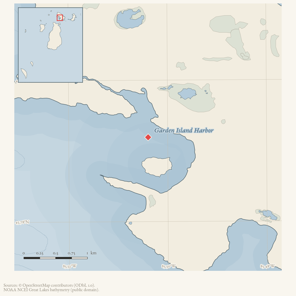
Garden Island Harbor is a bay on Garden Island, connected by a navigable channel to the smaller Indian Harbor. Its physical identity is recorded by GNIS; the local sources provide a more detailed, but twentieth-century, description of how the harbor was approached and used.
A July 1965 Beaver Beacon travel account describes passing the Garden Island passage buoy, avoiding a long rock reef extending from the south side of the harbor, and following the deep channel into Garden Harbor and then Indian Harbor. The account presents inter-island travel as requiring care; it does not provide survey soundings. A March 1962 Charlevoix report records a proposal for dock slips at Garden Island, but no source held here confirms construction.
A May 1988 Beacon note records a later stage of the harbor’s navigation aids: a Coast Guard cutter set a flashing channel marker between Garden and Beaver Island on May 5, and flashing buoys in the harbor itself on May 14, 1988, distinct from the passage buoy the 1965 account describes. An August 1984 note records a Central Michigan University Biological Station fisheries class tagging smallmouth bass “in Garden Island and Indian Harbors on Garden Island,” part of a fourteen-year study supervised by Dr. Herb Lenon, predating the 2017 MNFI fen survey below by more than three decades.
The harbor also appears in local social history. A February 1967 retrospective recalls High Island Israelite community outings to a field along Indian Harbor’s eastern shore, where visitors played ball and returned by boat. The account connects the harbor to the neighboring island communities without treating that recollection as proof of a permanent settlement at the harbor.
Ecological profile
MNFI Report 2017-11 records a 66-acre Garden Island Harbor northern fen occurrence (EO 11804, report p. 102; rank AB, G3G5/S3). The fen is primarily an expansive floating mat with marl pools, marl flats, and a shrubby-fen zone. Its fine-scale ecological zonation follows gradients in soil and water chemistry: sphagnum hummocks and hollows produce changing moisture conditions, while groundwater seepage supplies nutrient-rich growing conditions.
Floating portions have 30–40 cm of peat over water. Grounded portions contain alkaline peat and marl (pH 8.0), generally 10–20 cm deep over wet sands, with inundated peat in local marl pools. Wiregrass sedge, native reed, twig-rush, sweet gale, spike-rush, white beak-rush, beak-rush, Kalm’s lobelia, false asphodel, grass-of-Parnassus, bog arrow-grass, tufted bulrush, pitcher-plant, and several sedges are recorded. Stunted northern white-cedar and tamarack occur in the understory and overstory.
Beaver activity and crayfish burrows were noted throughout the wetland complex. The older fen portions were identified as places to survey for Hine’s emerald dragonfly, a state- and federally threatened species; that recommendation is not evidence of a confirmed observation. Glossy buckthorn was observed west of the fen along a beaver dam. MNFI recommends retaining an intact surrounding buffer, monitoring invasive species, and controlling and monitoring the glossy buckthorn. These are 2017 occurrence-level observations and recommendations, not a current wetland boundary, ownership record, or complete fauna inventory. The occurrence is not a complete survey of Garden Island Harbor.
Open questions
- Was the 1962 dock-slip proposal completed, and where were the facilities?
- How do historical charts identify the Garden Island passage, reef, and harbor channel, and do their names correspond to current GNIS features?
- Can current wetland, hydrology, and land-status records locate the MNFI fen relative to the navigable channel and Indian Harbor without conflating the occurrence with the harbor geometry?
Maps for this place
These Atlas plates provide regional context. They do not establish a precise boundary, current ownership, access right, operating status, or field condition.
- EnvironmentSoils, wetlands, hydrography, and terrain
- GeologyGeneralized geology and landforms
- HydrologyMapped water and wetland context
- AccessMapped routes, facilities, and protected areas
Sources
- GNIS feature 626638; feature class 'Bay'.federal · gnis · gnis_names
- Describes the Garden Island passage buoy, a rock reef extending from the south side of Garden Harbor, the deep channel into Garden Harbor, and the route into Indian Harbor.data1 · beaver-island-archive · beaver_beacon · 1965-07_Beaver-Beacon
- The held six-page issue scan is paired with the OCR source and confirms the published notice or report; it does not expand the source-specific identity, event, or outcome claims.data1 · beaver-island-archive · scans · beaver_beacon · issues · 1965-07_Beaver-Beacon
- Charlevoix Courier, March 8, 1962, “To Improve B. I. Dock Facilities.”Reports a plan to work with the Michigan Conservation Department to construct dock slips at High and Garden Islands; it does not establish that the slips were built. No public copy of this file is known; the archive holds one and can provide it on request.
- Recalls High Island Israelite community outings to a field along the eastern shore of Indian Harbor on Garden Island.data1 · beaver-island-archive · beaver_beacon · 1967-02_Beaver-Beacon
- The held six-page issue scan is paired with the OCR source and confirms the published notice or report; it does not expand the source-specific identity, event, or outcome claims.data1 · beaver-island-archive · scans · beaver_beacon · issues · 1967-02_Beaver-Beacon
- Project-generated MNFI 2017 soil, vegetation, and wildlife crosswalk, preserving MNFI Report 2017-11, Garden Island Harbor northern fen occurrence (EO 11804), report p. 102.Described in this archive: MNFI soil, vegetation, tree, and wildlife crosswalk, 2017.The 66-acre MNFI northern-fen occurrence is associated with the named harbor; it is not a current shoreline boundary, ownership determination, legal wetland delineation, or complete survey of the harbor. No public copy of this file is known; the archive holds one and can provide it on request.research · island_farming · crosswalks · mnfi_soil_vegetation_wildlife_crosswalk
- Visual page evidence held with provenance sidecar; the image anchors the fen occurrence and does not establish modern geometry or current condition.research · island_farming · evidence · mnfi-report-2017-11-page-0102-garden-island-harbor-fen
- Reports "Coast Guard cutter set flashing channel marker between Garden and Beaver Island May 5th and set flashing buoys in harbor on May 14, 1988" -- a dated record of Coast Guard navigation-aid work distinct from the 1965 Beacon travel account's description of the passage buoy and reef. The holding institution's portal restricts automated access; the archive holds a copy of this issue and can provide it on request.data1 · beaver-island-archive · beaver_beacon · 1988-05_Beaver-Beacon
- Reports that a Fisheries Biology class from the Central Michigan University Biological Station tagged smallmouth bass "in Garden Island and Indian Harbors on Garden Island" as part of a 14-year study supervised by Dr. Herb Lenon of CMU. The holding institution's portal restricts automated access; the archive holds a copy of this issue and can provide it on request.data1 · beaver-island-archive · beaver_beacon · 1984-08_Beaver-Beacon
Added 28 July 2026 · revised 3 August 2026. Recent changes
Cite this article
Beaver Island Archive, “Garden Island Harbor”, https://beaverislandarchive.org/places/garden-island-harbor/, accessed [date], citing U.S. Geological Survey, Geographic Names Information System, Domestic Names (Michigan), retrieved 2026-07-28. (and 9 further sources listed on the page).
Last revised 2026-08-03. Fill in [date] with the date you read it — this page is static and cannot know that.
BibTeX for “Garden Island Harbor”RIS for “Garden Island Harbor”