

The archive's own cartography · historical and environmental plates
Atlas
Print-quality plates drawn from the archive's data — free to download and reuse with the credits printed on each sheet, which are a condition of the licences the underlying data carries. Interactive maps are coming; the plates are the canonical record, and the atlas grows as the archive does.
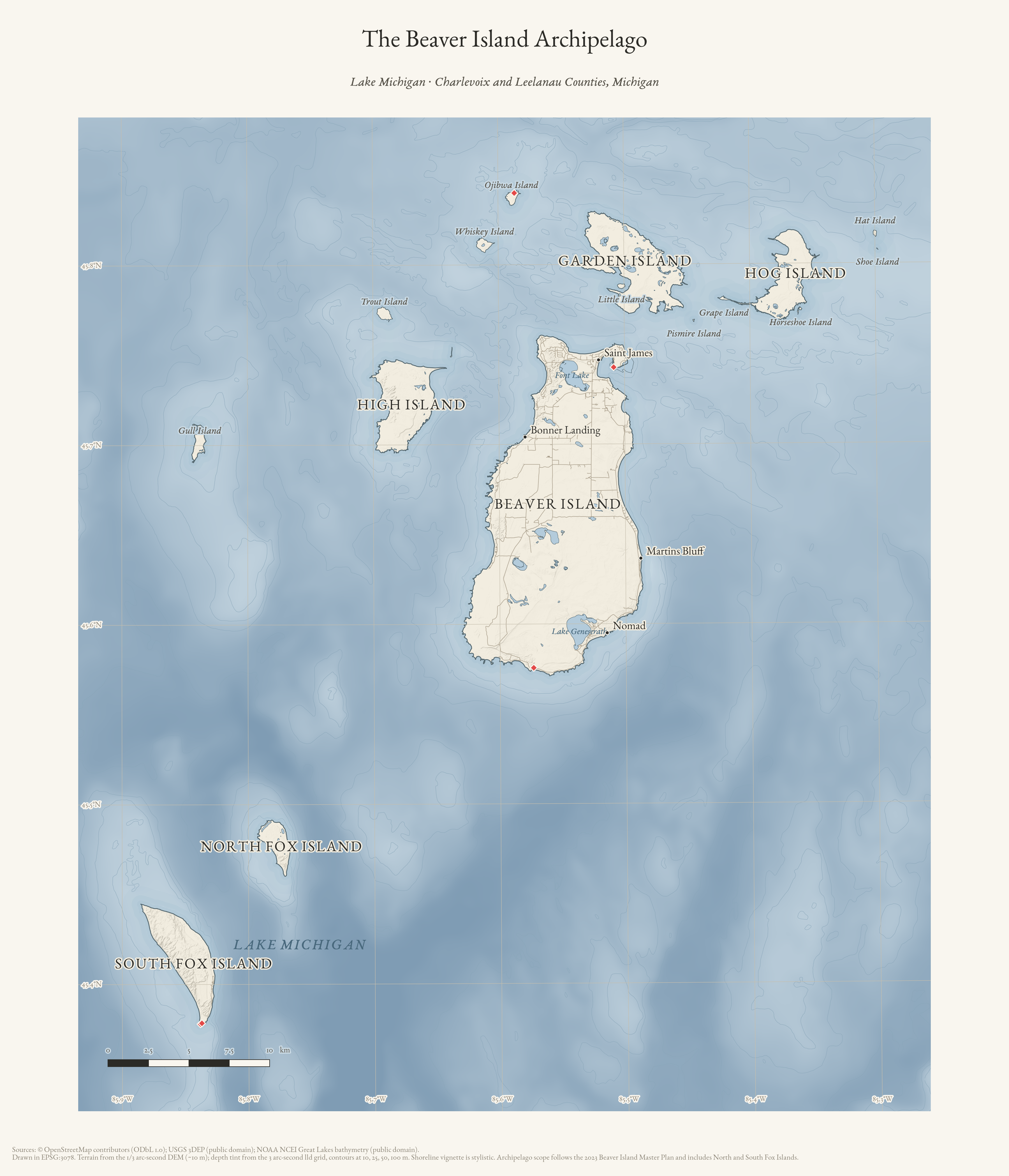
The Beaver Island Archipelago
Reference map of the archipelago with terrain and bathymetric depth tinting — fifteen islands on the shallow shelf of northern Lake Michigan, with North and South Fox. Archipelago scope follows the 2023 Beaver Island Master Plan.
Drawn from the archive's own data in EPSG:3078. Map data © OpenStreetMap contributors (ODbL 1.0); terrain USGS 3DEP (public domain); bathymetry NOAA NCEI (public domain).
Print PNG · PDF · Browse the places it names · Provenance & citation
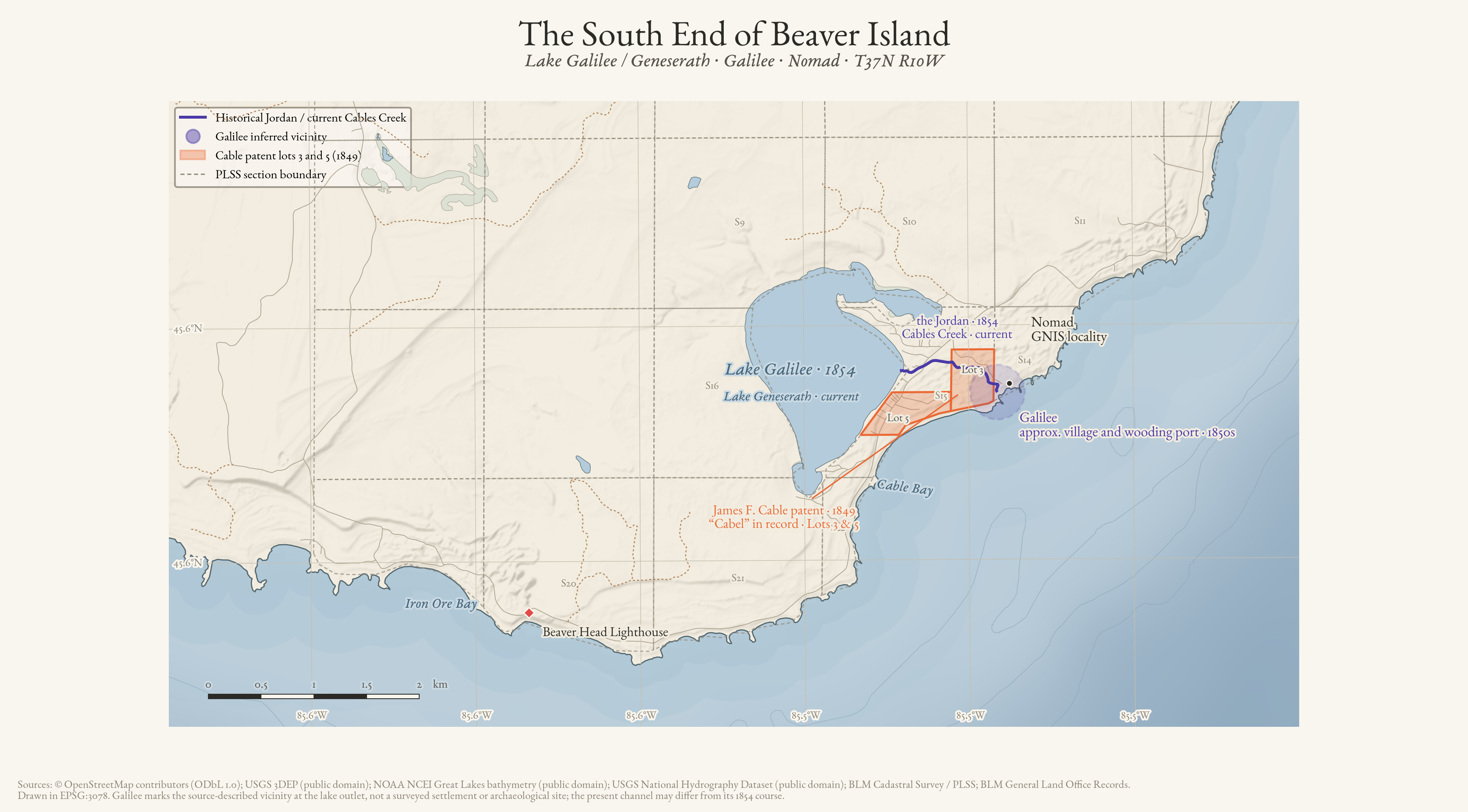
The South End of Beaver Island
Historical geography of the island's south end: Lake Galilee of 1854 over today's Lake Geneserath, the inferred vicinity of Galilee, James F. Cable's 1849 patent lots, and the Jordan — now Cables Creek — against the PLSS survey grid.
Drawn from the archive's own data in EPSG:3078. Map data © OpenStreetMap contributors (ODbL 1.0); USGS 3DEP and National Hydrography Dataset (public domain); NOAA NCEI bathymetry (public domain); BLM Cadastral Survey / PLSS and General Land Office records.
Print PNG · PDF · Read: Lake Geneserath · Provenance & citation
Open the Historical Landscape Atlas →
Environmental atlas
Soils, wetlands, hydrology, and terrain
A separate atlas family makes the modern environmental layers useful at the scale they were mapped: one seven-island overview, local island sheets, and four Beaver Island detail frames. The symbols preserve the difference between SSURGO map units, NWI wetlands, and EGLE hydric soils.
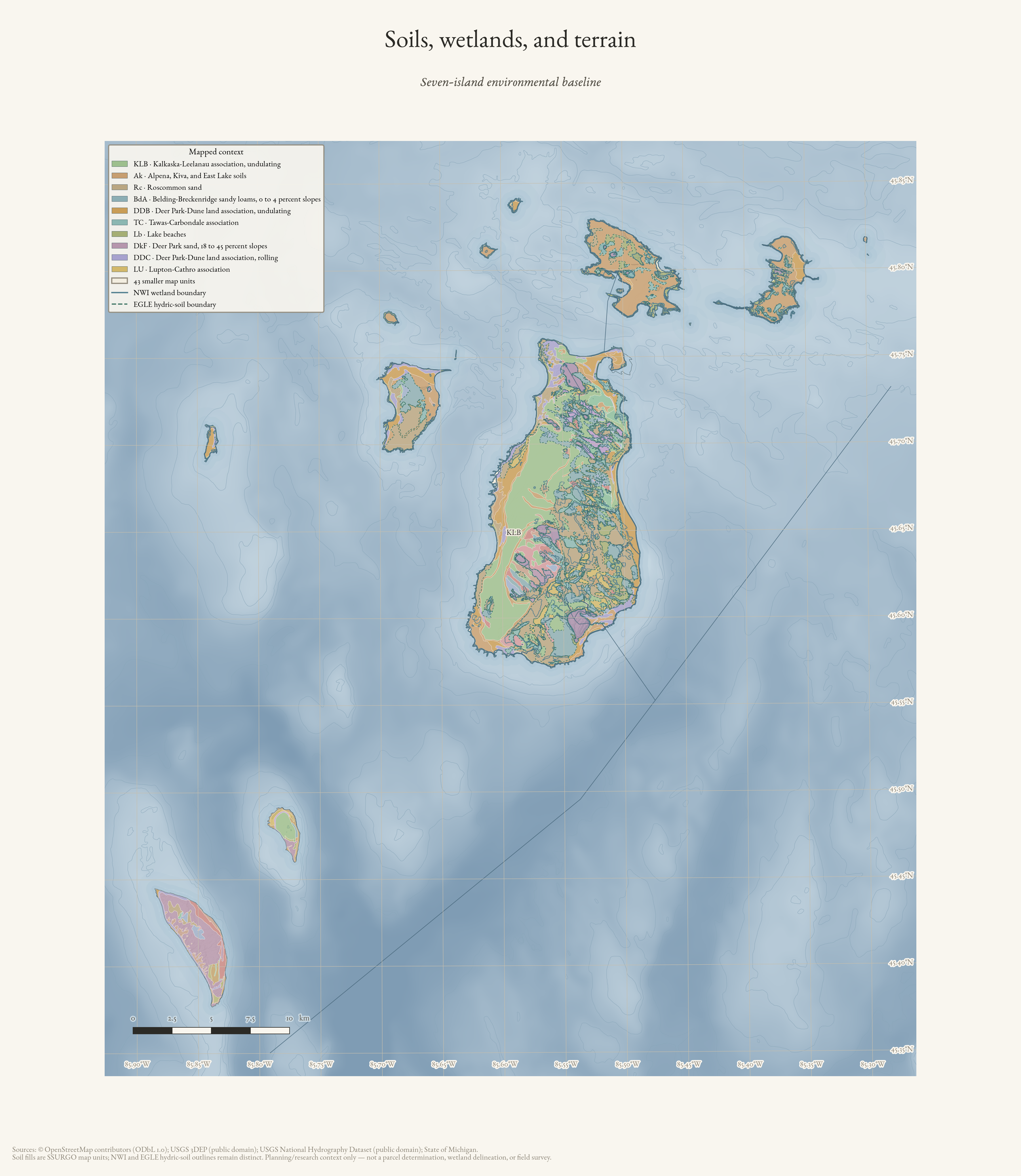
Soils, wetlands, and terrain
Seven-island environmental baseline: SSURGO map units with distinct NWI and EGLE hydric-soil outlines over terrain.
Drawn from the archive's own data in EPSG:3078. Map data © OpenStreetMap contributors (ODbL 1.0); SSURGO soils, USFWS National Wetlands Inventory, Michigan EGLE hydric soils, USGS 3DEP, and National Hydrography Dataset (public domain).
Print PNG · PDF · Read the map record · Provenance & citation
Physical geography atlas
Geology and landforms
A second modern survey family distinguishes generalized Quaternary geology, bedrock contacts, glacial landsystems, and critical dunes. It is organized as an archipelago overview plus individual island plates.
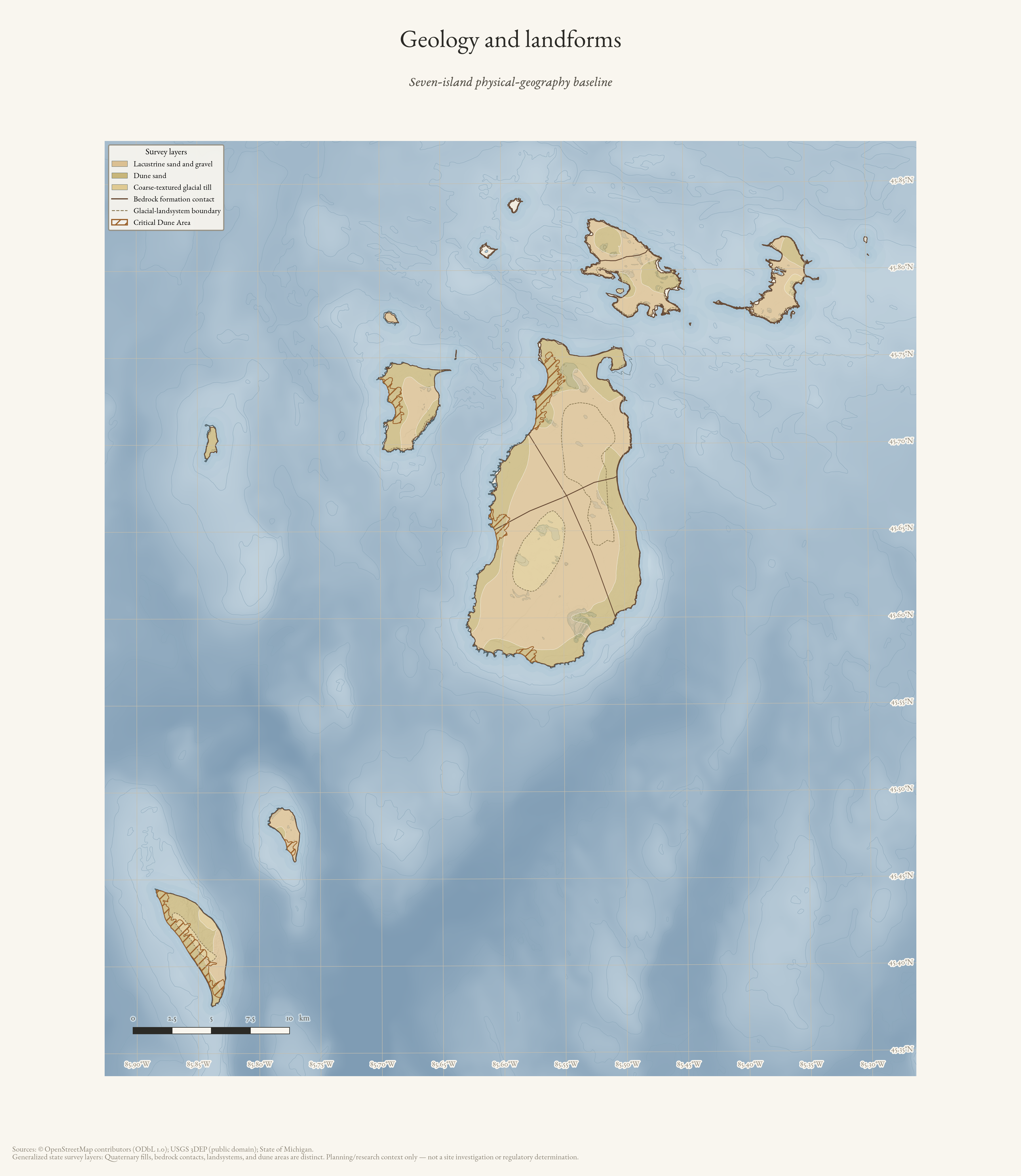
Geology and landforms
Seven-island physical-geography baseline: generalized Quaternary units with distinct bedrock, landsystem, and critical-dune survey symbols.
Drawn from the archive's own data in EPSG:3078. Map data © OpenStreetMap contributors (ODbL 1.0); Michigan Geological Survey Quaternary and bedrock geology, glacial landsystems, critical dune areas, and USGS 3DEP (public domain).
Hydrology atlas
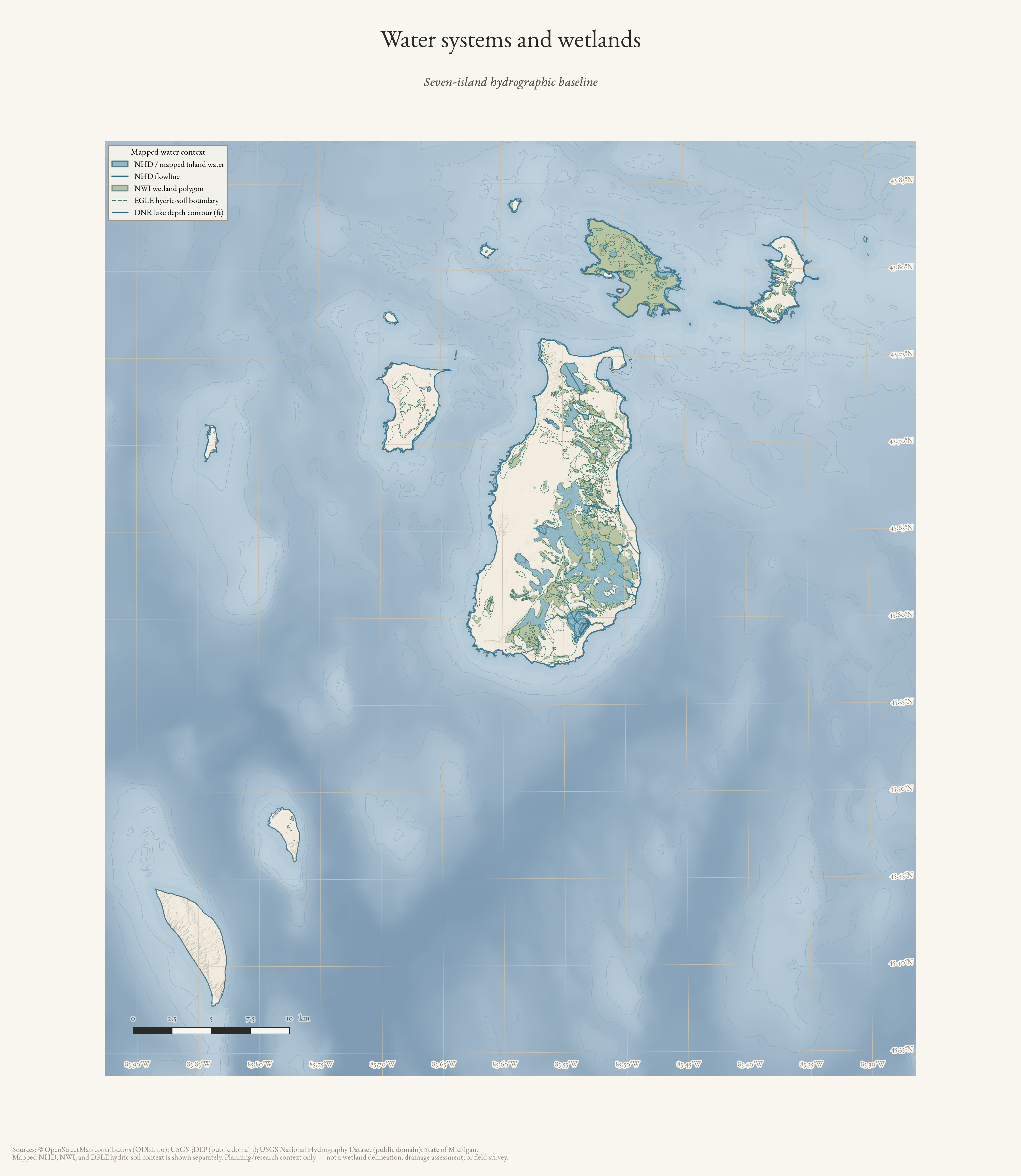
Water systems and wetlands
Dedicated water-system plates retain the difference between hydrography, wetlands, and hydric-soil context. They are available as an archipelago overview and individual island sheets.
Water systems and wetlands
Seven-island hydrographic baseline: NHD water and flowlines with distinct NWI wetland and EGLE hydric-soil context.
Drawn from the archive's own data in EPSG:3078. Map data © OpenStreetMap contributors (ODbL 1.0); USGS National Hydrography Dataset, USFWS National Wetlands Inventory, Michigan EGLE hydric soils, and USGS 3DEP (public domain).
Land Survey Atlas
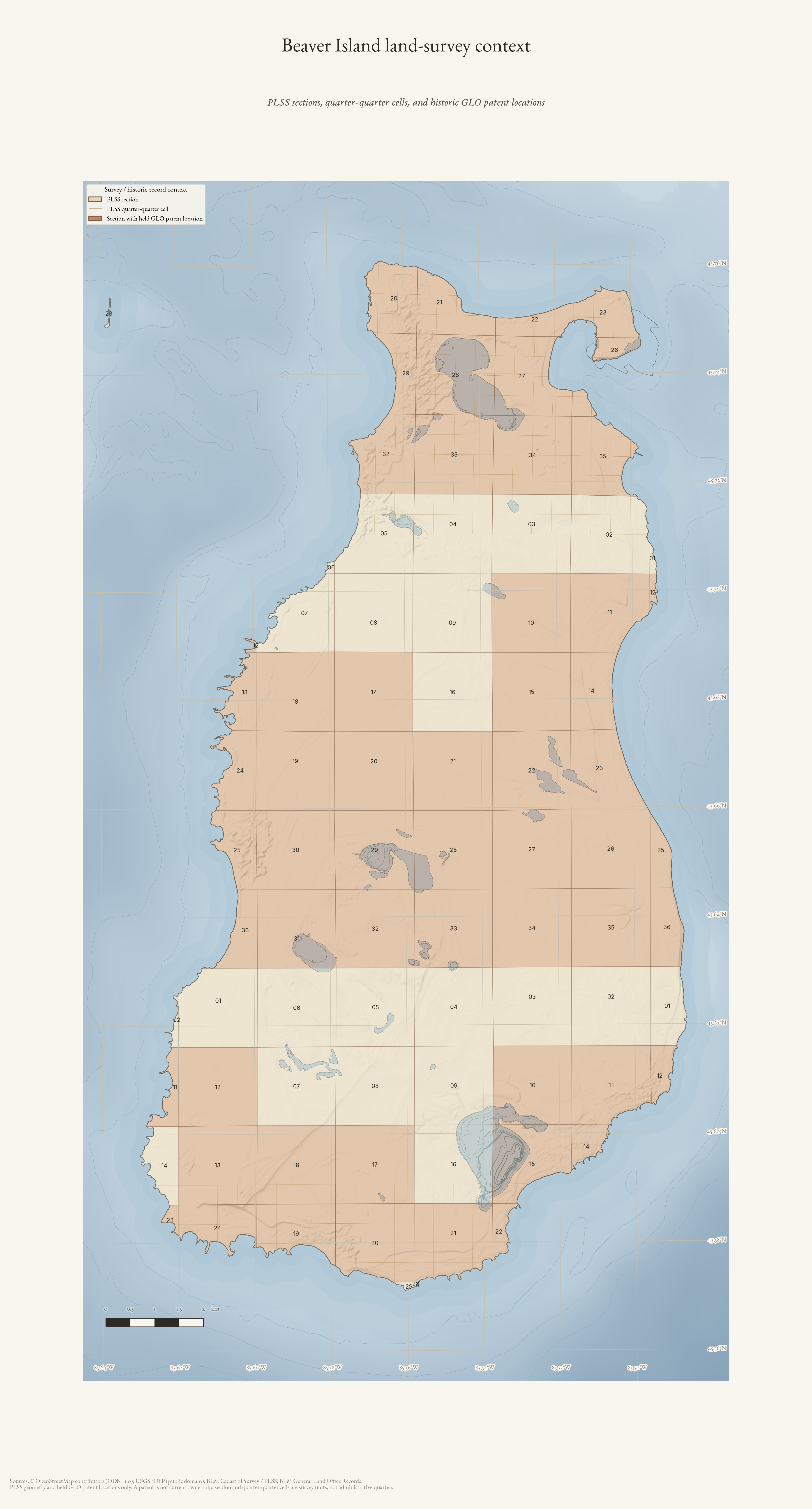
PLSS and historic patent context
Survey cells and historic GLO patent locations make the records navigable without implying modern ownership. Beaver Island’s overview leads to four deliberately non-administrative detail frames.
Beaver Island land-survey context
PLSS sections and quarter-quarter survey cells with sections containing held historic GLO patent locations—not current ownership.
Drawn from the archive's own data in EPSG:3078. Map data © OpenStreetMap contributors (ODbL 1.0); BLM Cadastral Survey / PLSS and BLM General Land Office Records; Michigan Geographic Framework PLSS; USGS 3DEP (public domain).
Access Atlas
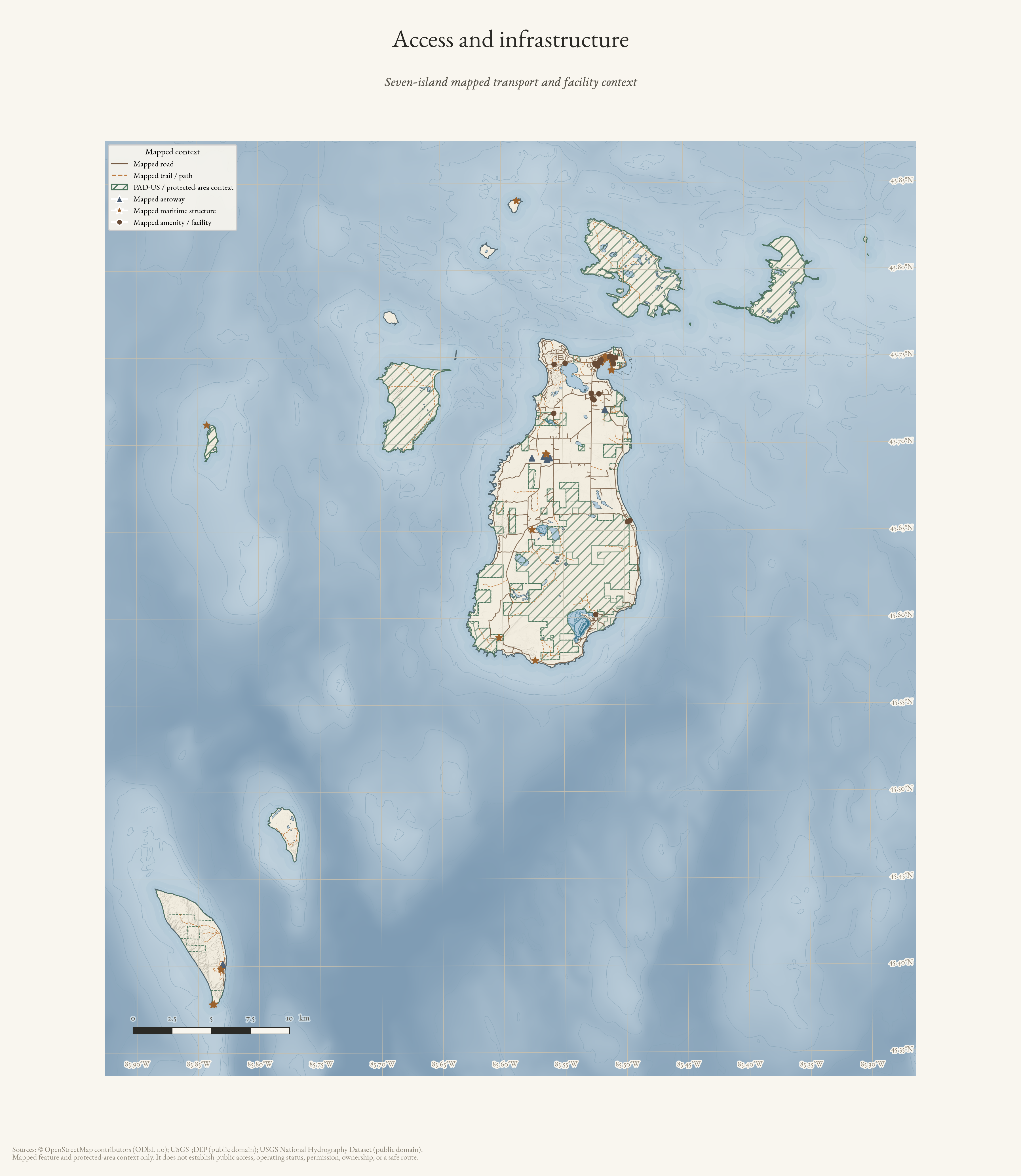
Access and infrastructure
Mapped transport, facilities, and protected-area context are useful orientation—not proof of permission, public access, operation, ownership, or a safe route.
Access and infrastructure
Seven-island mapped roads, trails, facilities, maritime structures, aeroways, and protected-area context—not an access-rights map.
Drawn from the archive's own data in EPSG:3078. Map data © OpenStreetMap contributors (ODbL 1.0); PAD-US protected-area context and USGS 3DEP (public domain).
Maritime Atlas
Coasts, harbors, and navigation context
NOAA bathymetric reference, GNIS named harbor locators, and mapped waterfront features connect the islands without pretending to be a navigation chart. Source dates and limits rule out route, current-status, safe-passage, ownership, shoreline-change, and wreck-location claims.
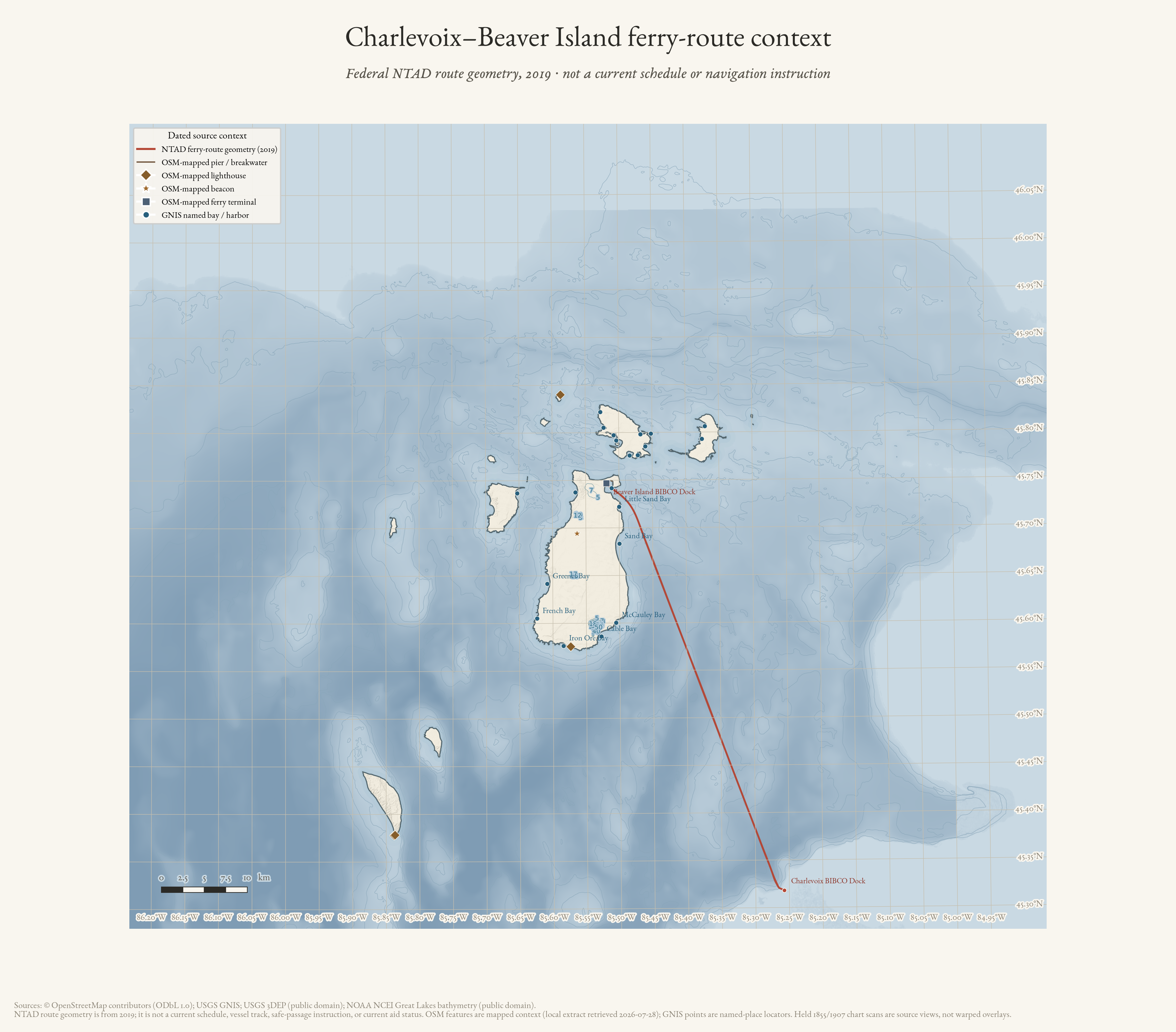
Charlevoix–Beaver Island ferry-route context (2019)
Federal NTAD route geometry in regional bathymetric context; not a current schedule, vessel track, or navigation instruction.
Drawn from the archive's own data in EPSG:3078. Map data © OpenStreetMap contributors (ODbL 1.0); USGS GNIS and 3DEP; NOAA NCEI Great Lakes bathymetry (public domain).
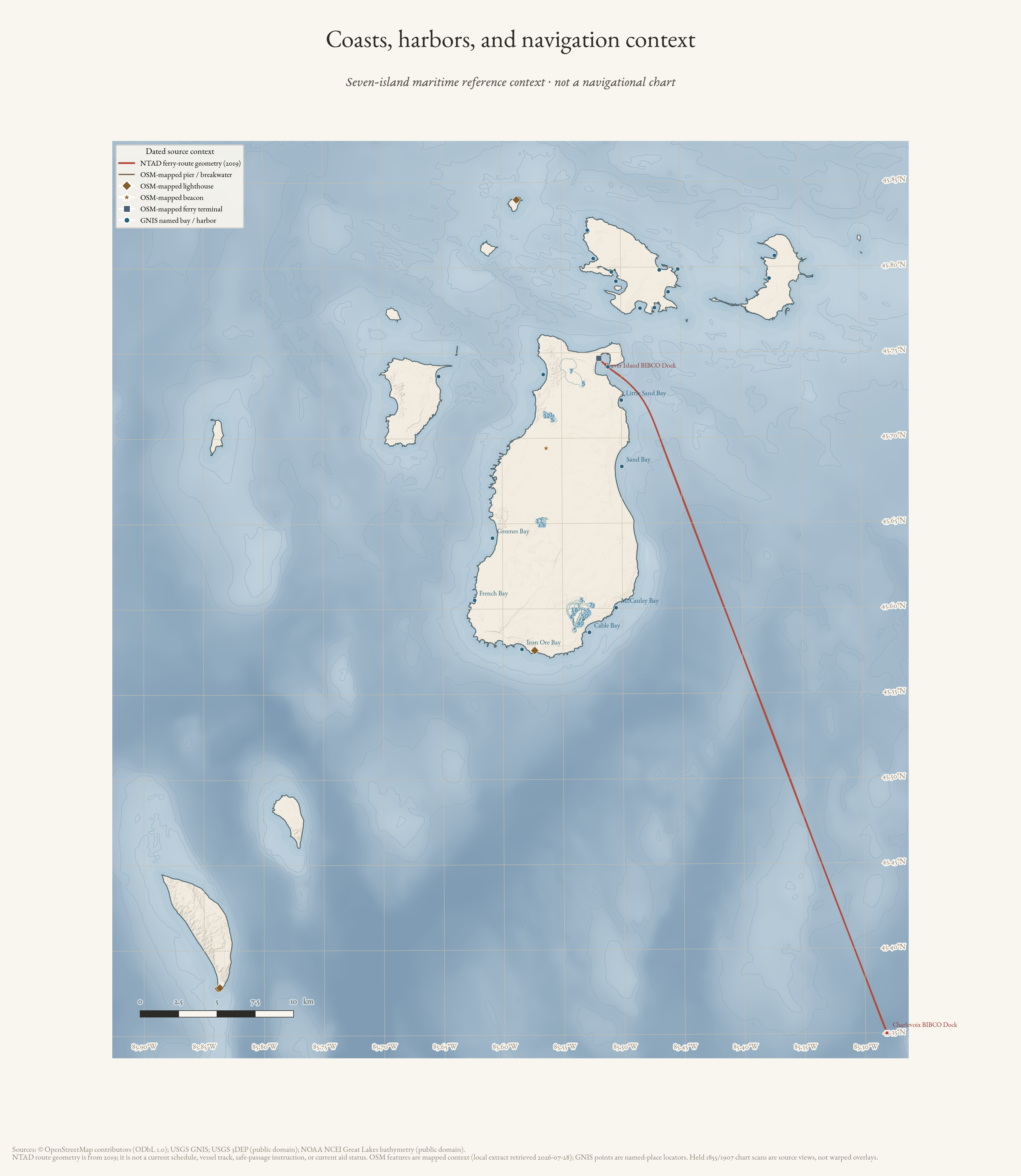
Coasts, harbors, and navigation context
Seven-island NOAA bathymetry, GNIS named harbors, and mapped waterfront features—not a navigational chart.
Drawn from the archive's own data in EPSG:3078. Map data © OpenStreetMap contributors (ODbL 1.0); USGS GNIS and 3DEP; NOAA NCEI Great Lakes bathymetry (public domain).
Ecology Atlas
Vegetation and ecological-community context
Public Annual NLCD land-cover classes at 30 m provide the spatial layer. The held MNFI natural-community survey contributes named, dated stewardship context without exposing or inventing occurrence geometry.
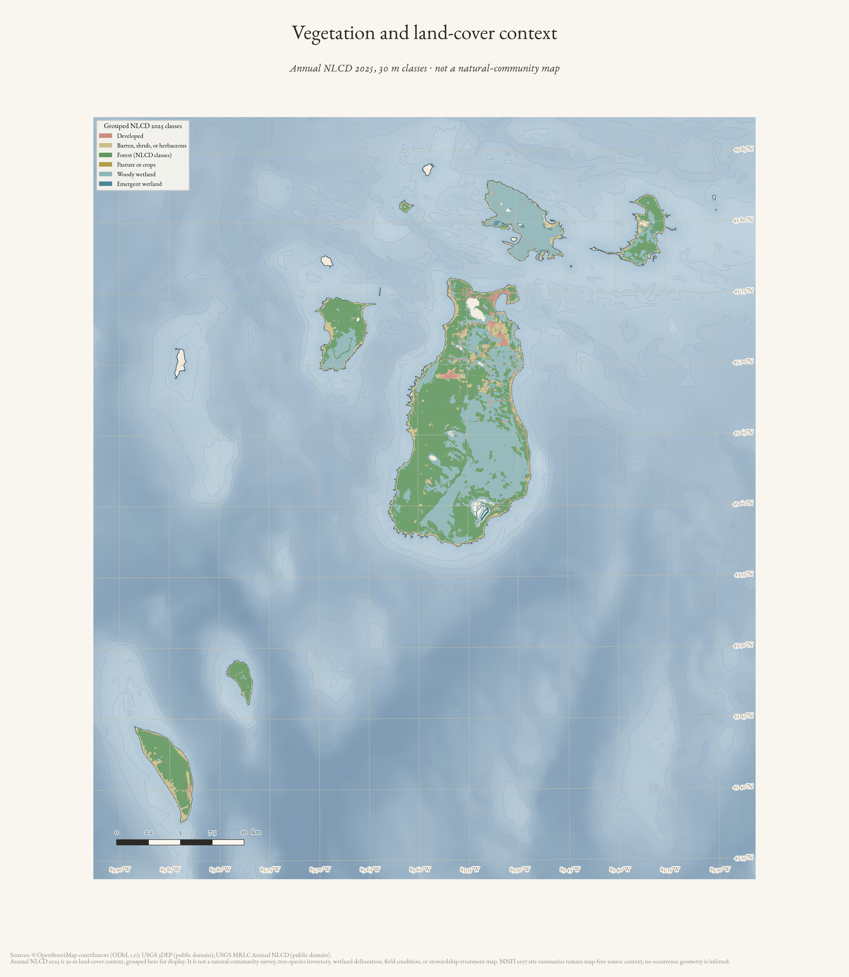
Vegetation and land-cover context
Seven-island Annual NLCD 2025 land-cover context at 30 m—not a natural-community map.
Drawn from the archive's own data in EPSG:3078. Map data © OpenStreetMap contributors (ODbL 1.0); USGS MRLC Annual NLCD and USGS 3DEP (public domain).
Relief
The ground in three dimensions
The 1-metre bare-earth LiDAR the plates are hillshaded from, drawn as terrain you can turn and tilt in the browser. It opens on the whole island, then drops to 1-metre posting over Cable's Creek with Nomad and Galilee, St James and the north end, and two places worth a closer look. The features it exists to show are a few tenths of a metre high, so the vertical is exaggerated — and the factor is printed beside the view at all times. One frame is a control: two roads that are certainly there.
The same ground, as a sheet
The raster half of the same family. Bare-earth LiDAR joined to the lake floor — one continuous surface across about 160 metres of relief, at 5,106 × 8,936 pixels. Five sheets, because the same ground wants a different treatment depending on what you mean to do with it: hang it, plot it, cut it, or carve it. All free to download.
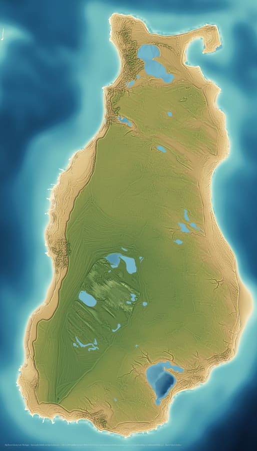 The printColour by elevation, lit from four directions, from 95 m below the lake surface to 74 m above it. The land is 1 m LiDAR and the lake floor is an acoustic grid 70 times coarser, which is why one is sharp and the other smooth. The four inland lakes the Michigan DNR has sounded — Geneserath, Font, Fox and Barney's — carry their own measured floors; the rest of the island's lakes have never been sounded and stay flat.
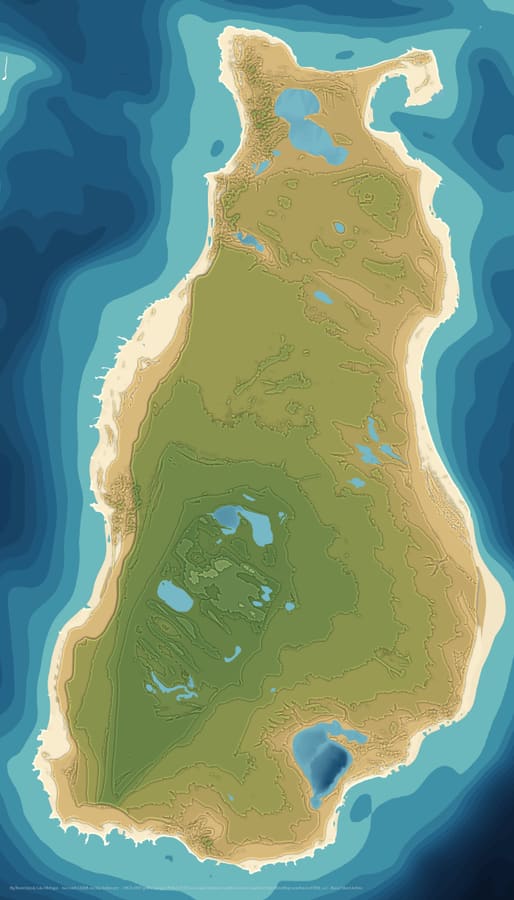 Stepped bandsElevation cut into 6 m steps, one flat tone each. This is the sheet to work from for a stacked-plywood or laser-cut relief: each band is one layer. Lake Geneserath steps down through its own bands, its floor falling below Lake Michigan datum.
Data
Take the layers with you
Everything above is a picture the archive drew. The GIS package is the data underneath it, in the formats a GIS opens — a GeoPackage with the styles built in, a QGIS project, an Esri File Geodatabase and a KMZ for Google Earth. It carries every layer the archive may redistribute, and the knowledge base itself as geometry: each record a point or a route with a link back to its sourced article. Load it over whatever basemap you already use.