

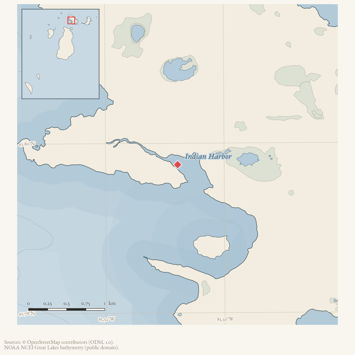
- Coordinates
- 45.7975° N, 85.5079° WGoogle Maps: Indian HarborDownload KML
- Eras
- Modern era
- Concepts
- environmentgeologysoilswetlandshydrologyforeststreesvegetationplantswildlifeanimalsbirdsconservationstewardshipinvasive-speciesmaritimetourismheritage
- Within
- Garden Island
Summary
Indian Harbor is a named bay on Garden Island, reached in a July 1965 Beaver Beacon travel account by following the channel through Garden Island Harbor. The visitors brought their boat to the beach and walked north through the site of an old Indian Village to a burial ground. Their account describes wood-shingled shelters over graves, many in poor condition, and says the latest grave they observed was dated 1938. This is a dated visitor account, not an archaeological survey or a complete chronology of the cemetery.
The map published with the same account labels Indian Harbor, Indian Village, Indian Cemetery, and Garden Island Harbor as distinct nearby features. The account supports Indian Harbor as both a navigation point and an access route to Garden Island’s Indigenous heritage sites, while leaving exact trail alignments, boundaries, and present access protocols open.
History
A separate 2005 Beaver Beacon retrospective on Garden Island, by Jeff Cashman, places the 1836 treaty context behind the Indian Village that the 1965 map locates at Indian Harbor: the treaty held Garden Island’s land back from sale to non-Indians, and Chief Peaine resided on the island while most Garden Islanders there lived in log cabins. The account describes a settlement history running from early intermarriage between Indian and white residents — including James Morey, shipwrecked on Whiskey Island, who “married in” and later fathered a line leading to the medicine woman Keewaydinoquay — through Danish homesteaders arriving from about 1875, to the last full-time Indian resident, farmer and fisherman Pete Manitou, who died in 1947, after which permanent settlement ended.
Within that settlement, the account places specific activity at Indian Harbor itself: a school operating between 1910 and 1915 had 19 students, of whom 3 were Indian, and “the House of David came over from High to play baseball in the clearing at Indian Harbor” — a reference to the House of David religious colony, then resident on High Island. A church was built, with a priest visiting for baptisms, marriages, and funerals; a lumber camp near Garden Island Harbor employed local residents and brought in outside workers; and a store kept by a man named Bellisinger briefly operated as a United States Post Office named Success, in 1912. The account gives no exact location for the church within the settlement and does not state whether it stood at Indian Harbor itself or elsewhere in the village.
Ecological profile
MNFI Report 2017-11 records two distinct natural-community occurrences at Indian Harbor: a 4-acre coastal fen (EO 21328, report p. 35; rank B, G1G2/S2) and a 57-acre Great Lakes marsh (EO 13020, report pp. 60–61; rank AB, G2/S3). They should not be collapsed into one habitat polygon or treated as the GNIS bay boundary. Both communities are dynamic shoreline systems whose margins shift with Great Lakes water levels, storms, and substrate movement.
The MNFI occurrences are not a current legal boundary, ownership determination, or complete survey of Indian Harbor.
The coastal fen has shallow 1–2 cm alkaline organics (pH 8.0) over wet alkaline gravelly sands and cobble. It grades lakeward into Great Lakes marsh and limestone cobble shore and is backed by rich conifer swamp and boreal forest. Wiregrass sedge, sedge, twig-rush, beak-rush, false asphodel, grass-of-Parnassus, Kalm’s lobelia, Ohio goldenrod, limestone calamint, bastard-toadflax, bog arrow-grass, and Baltic rush are among its recorded plants. Shrubby cinquefoil, Kalm’s St. John’s-wort, and scattered northern white-cedar occur in the shrub and understory layers. No threats were observed in that survey, but MNFI recommends maintaining natural buffers and groundwater seepage while monitoring for invasive plants.
The adjacent marsh has shallow organics, generally 0–1 cm, over wet alkaline sandy gravel, sandy clay, and cobble (pH 7.8–8.0). Water depth ranges from 0 to 150 cm: emergent areas commonly hold 50–150 cm, while saturated meadow areas hold 0–50 cm. Seasonal fluctuations, seiches, storm surges, multi-year lake cycles, and storm-wave reworking control the substrate and vegetation. High water can reduce or remove organic soils and established vegetation, while low-water periods allow marsh plants and organic material to build.
The marsh provides documented fish-spawning habitat and supports diverse shorebirds and secretive marsh birds. Two state-special-concern American bitterns were observed in the 2017 survey, and Odawa DNR marsh-bird surveys documented Virginia rail and sora. Baltic rush, threesquare, hardstem bulrush, twig-rush, sedges, and blue-joint occupy emergent and meadow zones. A flood-killed northern white-cedar on the upper marsh margin was estimated at 15–20 years old. Reed, narrow-leaved cattail, white sweet-clover, and wild parsnip were recorded as invasive or locally invasive plants in and around the marsh. MNFI recommends allowing natural lake-level processes, maintaining shoreline buffers, and controlling and monitoring invasive plants. These are source-bounded survey observations, not a complete bird census, fishery assessment, or current wetland delineation.
Open questions
- How do historical charts and current management maps define Indian Harbor’s shoreline and its relationship to Garden Island Harbor?
- Can the 1965 trail and burial-ground description be reconciled with the Garden Island Indian Cemetery’s National Register boundary and archaeological documentation?
- How do the MNFI fen and marsh occurrences relate to current shoreline change, fish-spawning areas, bird surveys, and Garden Island land-status records?
- Where within the Indian Harbor settlement did the church described in the 2005 account stand, and does any record beyond that account confirm the House of David’s baseball games there or the short-lived Success post office?
See also
Maps for this place
These Atlas plates provide regional context. They do not establish a precise boundary, current ownership, access right, operating status, or field condition.
- EnvironmentSoils, wetlands, hydrography, and terrain
- GeologyGeneralized geology and landforms
- HydrologyMapped water and wetland context
- AccessMapped routes, facilities, and protected areas
Sources
- GNIS feature 1618187; feature class 'Bay'.federal · gnis · gnis_names
- Describes reaching Indian Harbor through the Garden Harbor channel, bringing the boat to the beach, and walking trails through the site of an old Indian Village to a burial ground with moss-covered wooden shelters and a latest grave dated 1938.data1 · beaver-island-archive · beaver_beacon · 1965-07_Beaver-Beacon
- The held six-page issue scan is paired with the OCR source and confirms the published notice or report; it does not expand the source-specific identity, event, or outcome claims.data1 · beaver-island-archive · scans · beaver_beacon · issues · 1965-07_Beaver-Beacon
- The locally printed map labels Indian Harbor, Indian Village, Indian Cemetery, and Garden Island Harbor as separate features; the OCR transcription does not provide survey coordinates.data1 · beaver-island-archive · beaver_beacon · 1965-07_Beaver-Beacon
- The held six-page issue scan is paired with the OCR source and confirms the published notice or report; it does not expand the source-specific identity, event, or outcome claims.data1 · beaver-island-archive · scans · beaver_beacon · issues · 1965-07_Beaver-Beacon
- Project-generated MNFI 2017 soil, vegetation, and wildlife crosswalk, preserving the Indian Harbor coastal fen (EO 21328, report p. 35) and Great Lakes marsh (EO 13020, report pp. 60–61) occurrences from MNFI Report 2017-11.Described in this archive: MNFI soil, vegetation, tree, and wildlife crosswalk, 2017.The two records are distinct survey-defined natural-community occurrences associated with the named harbor; they are not a current shoreline boundary, cemetery boundary, ownership determination, or complete survey of Indian Harbor. No public copy of this file is known; the archive holds one and can provide it on request.research · island_farming · crosswalks · mnfi_soil_vegetation_wildlife_crosswalk
- Visual page evidence held with provenance sidecar; the image anchors the fen occurrence and does not establish modern geometry or current condition.research · island_farming · evidence · mnfi-report-2017-11-page-0035-indian-harbor-coastal-fen
- Visual page evidence held with provenance sidecar; the image anchors the marsh occurrence and does not establish modern geometry or current condition.research · island_farming · evidence · mnfi-report-2017-11-page-0060-indian-harbor-marsh
- Jeff Cashman, "A Trip to the North -- Northcutt ... and Pete Monatou's Bay," Beaver Beacon, November 2005.A travel/history feature on Garden Island recounting an October boat trip to Northcutt; describes the 1836 Treaty reservation of Garden Island for Indian purchase, Chief Peaine's residence there, and a settlement history running from log cabins through Danish homesteaders (from c. 1875) to the last full-time Indian resident's death in 1947. States that a school operating 1910-1915 had 19 students (3 Indian), that "the House of David came over from High to play baseball in the clearing at Indian Harbor," that a church was built and a priest visited for baptisms, marriages, and funerals, that a lumber camp near Garden Island Harbor employed locals, and that a store started by a man named Bellisinger briefly became a U.S. Post Office named Success in 1912. It is a 2005 retrospective feature, not a contemporary record of these events. No public copy of this file is known; the archive holds one and can provide it on request.
Added 28 July 2026 · revised 3 August 2026. Recent changes
Cite this article
Beaver Island Archive, “Indian Harbor”, https://beaverislandarchive.org/places/indian-harbor/, accessed [date], citing U.S. Geological Survey, Geographic Names Information System, Domestic Names (Michigan), retrieved 2026-07-28. (and 7 further sources listed on the page).
Last revised 2026-08-03. Fill in [date] with the date you read it — this page is static and cannot know that.