

- Dates
- 1930 – 1939
- Eras
- Modern era
- Concepts
- cartographyland-surveypropertyland-usesettlementfishingreligionanishinaabe-odawa
- Within
- Beaver Island
Summary
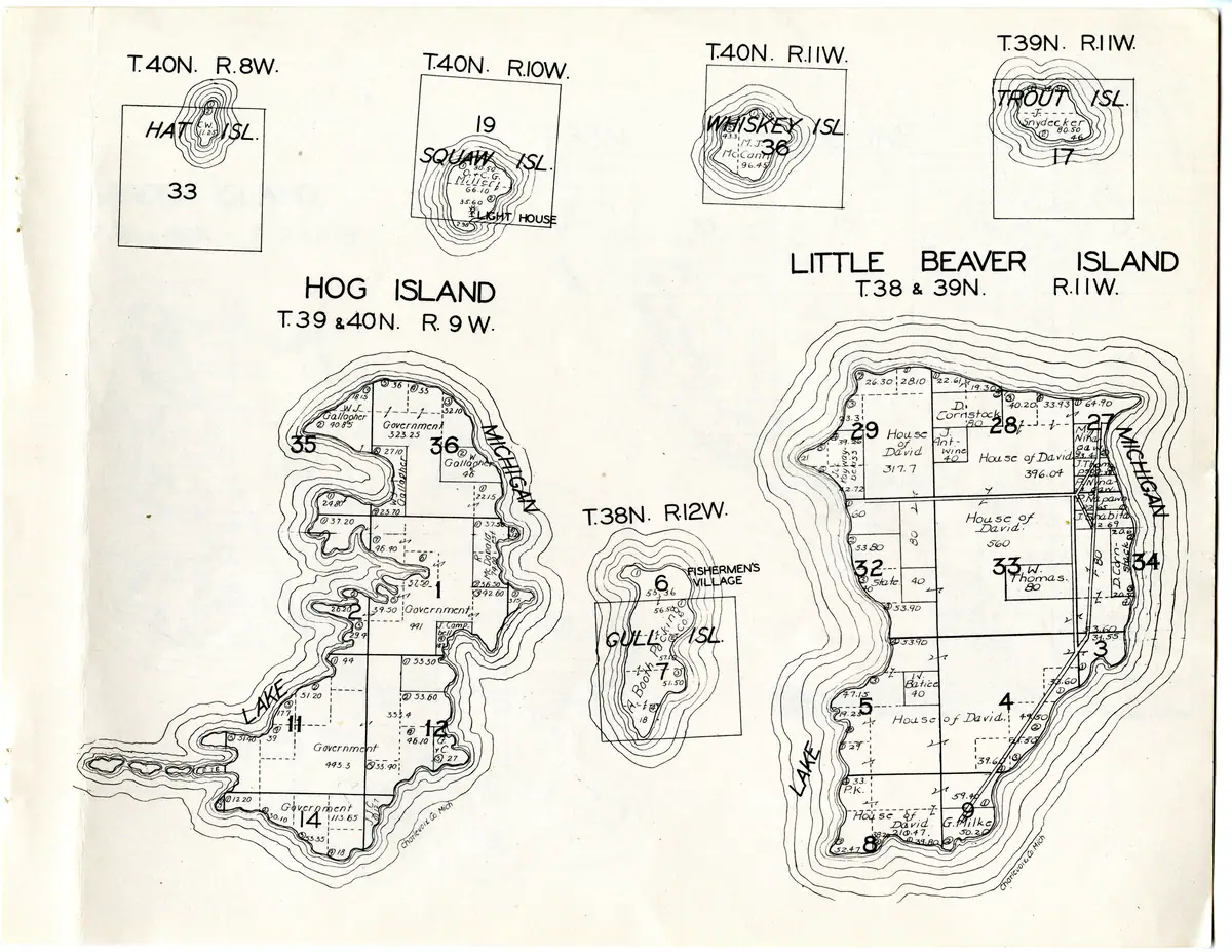
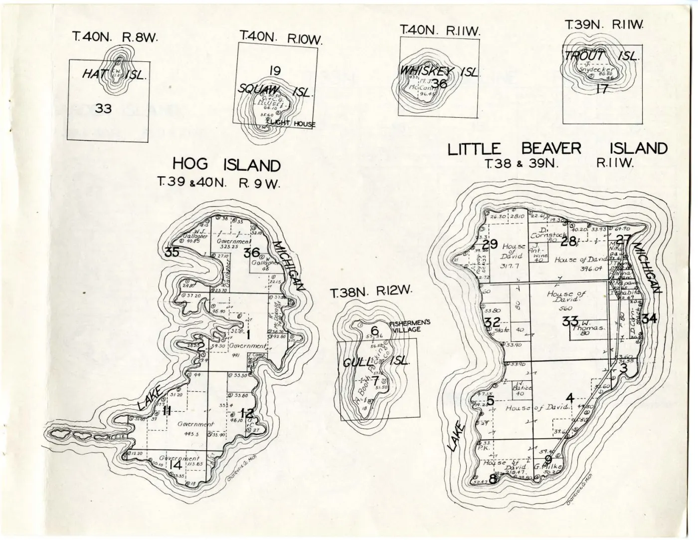
One leaf carrying seven separate island plats, each with its own township and range heading and its own scale of drawing: Hog Island, Little Beaver Island — the name this atlas and the 1849 federal survey both use for High Island — Gull Island, Squaw Island (Ojibwa Island), Whiskey Island, Trout Island and Hat Island.
It is the densest sheet in the volume for this archipelago and it carries the edition’s two most striking findings: High Island held almost entirely by the House of David, and the whole of Gull Island held by Booth Packing Company, with a labelled FISHERMEN’S VILLAGE on it.
Little Beaver Island — High Island under the House of David
LITTLE BEAVER ISLAND T. 38 & 39N. R. 11W.
Five large blocks of the island are lettered House of David: 317.7 acres in
section 29, 396.04 in section 28, 560 in section 33, and two further blocks in
sections 4 and 5, one of them 210.47. Between them they take in nearly the whole
interior and the whole southern half.
The rest is a scatter of smaller holdings. Along the east shore, in a narrow
strip of long lots between the interior blocks and Lake Michigan, are
M. Nihagaw 23.4, J. Thomps- , P. Ninagaw, P. Napawn 22.65 and
J. Shabita 22.69; on the west shore in section 29, Kayway-beck 55, its
owner’s initials indistinct at native resolution. D. Cornstock holds 80 acres
in section 28 and two shore parcels of about 20 acres each in section 34;
J. Antwine 40 and W. Thomas 80 sit inside the House of David ground, with
State 40, W. Batice 40, G. Milke 50.20 and a parcel marked P. K.
A road runs the length of the island’s east side as two solid parallel rules, from the south end up past section 27.
What this does and does not settle about the colony
The account of the House of David on High Island in High Island rests on secondary and retrospective sources that disagree: one gives 1912–1932 for the Israelite Colony, a 1967 local retrospective puts the arrival between 1906 and 1910 and the end after a 1930 court settlement, and a 1936 court report places a colony employee on the island.
This sheet is a different kind of evidence — a contemporaneous cadastral record, drawn from what the county carried, naming the colony as the holder of nearly the whole island. It is the only such record held here.
It does not settle the end date, for two reasons that must travel with any use of it. The volume’s own date is the ten-year range 1930–1939, so the sheet cannot be pinned to a year; and a county land record can lag a departure by years, so a name on a plat is not a statement that anyone was there. What the sheet establishes is that within that range the county’s record showed the House of David as High Island’s landholder, which none of the other held sources does.
W. Thomas 80 is a lead, not an identification. A March 1963 retrospective
held here reports that Claude Swafford, a House of David employee, was tried over
the death of William Thomas on High Island in 1936, and this sheet has a
W. Thomas parcel inside the colony’s ground. A surname and an initial are not
an identification, this archive does not join on one, and nothing here confirms
it. Recorded so that someone with the court file can test it.
Set against the 1901 plate, which marked a large number of this island’s parcels simply “Indian” with individual Anishinaabe owners named on others, the change is the largest single transfer of ground either edition of the atlas records.
Gull Island — Booth Packing Company and a fishing village
T. 38N. R. 12W.
Both sections drawn, 6 and 7, are lettered Booth Packing Co. across
acreages of 55.36, 56.50, 57.10, 51.50 and 18 — the whole island. Beside the
north end, in the same heavy capitals the sheet uses for a place name rather than
an owner, is FISHERMEN'S VILLAGE.
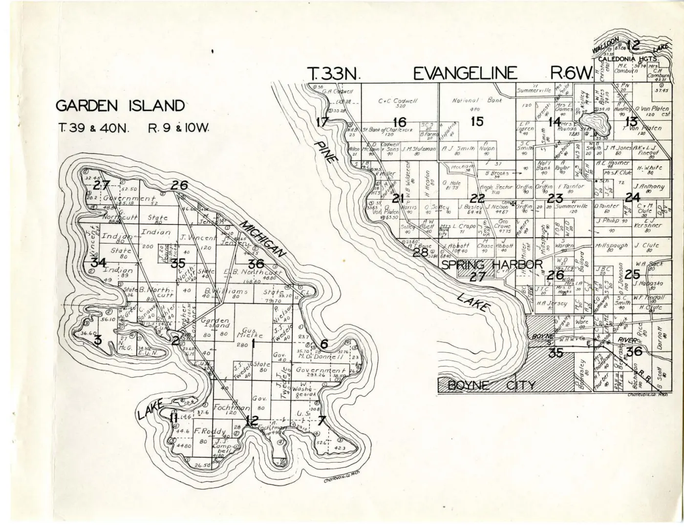
The 1901 edition drew Gull Island only as a small inset beneath the Garden Island plate. This is the first dated cadastral statement this archive holds that the island was held by a fish company and carried a named settlement.
Hog Island — almost entirely Government
HOG ISLAND T. 39 & 40N. R. 9W.
The island is overwhelmingly Government: blocks of 323.25, 991, 443.3 and
113.65 acres. The private holdings are few and small: W. J. Gallagher 40.85 and
a second W. Gallagher parcel of 46 in section 36, a strip lettered
W. J. Gallagher down the section line, R. McDonald 74.00 on the east shore,
J. Campbell 18.2, and a parcel marked G. & C. at 27.
The four small islands
Each is drawn as a single section square with the island floating inside it.
| Island | Township and range | Section | As lettered |
|---|---|---|---|
| Hat Isl. | T.40N. R.8W. | 33 | one holding, initials C. W., 11.25 |
| Squaw Isl. | T.40N. R.10W. | 19 | O. & C. G. Millert 66.10, with parcels of 30.50, 35.60 and 2.98, and a LIGHT HOUSE on the south point |
| Whiskey Isl. | T.40N. R.11W. | 36 | M. J. McCann 96.45, with a 43.31 parcel |
| Trout Isl. | T.39N. R.11W. | 17 | F. Snydecker 80.50, with a 46 parcel |
Squaw Island is Ojibwa Island under its earlier name; the sheet uses the old form throughout, which is what makes an atlas of this date searchable for it at all.
What is drawn, and what is not
No railway, no legend, no scale statement. The atlas defines none of its symbols, so the double-cased line down High Island’s east side is a road by resemblance to every other double-cased line in the volume and not by anything the sheet says. The small hooked mark drawn like a figure 6 recurs beside parcel labels here as on the island sheets, and any acreage above that looks larger than its parcel should be suspected of having absorbed it.
Open questions
- Whether the House of David blocks can be dated more closely from a deed, a county tax roll or the 1930 court settlement the 1967 retrospective mentions. That would convert a ten-year range into a date.
- Whether
W. Thomasis the William Thomas of the 1936 case. - Who Booth Packing Company were on Gull Island, and how long the
FISHERMEN'S VILLAGEwas occupied. - The Anishinaabe surnames on High Island’s east shore —
Nihagaw,Ninagaw,Napawn,Shabita,Kayway-beck— are given as lettered and several are uncertain at native resolution. None has an article here.
See also
Sources
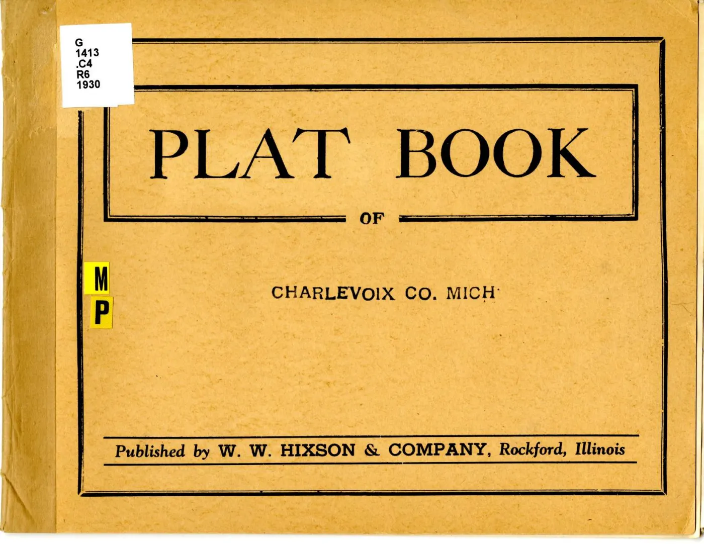
- W. W. Hixson & Company, the outer-islands sheet of Plat Book of Charlevoix
Co. Mich. (Rockford, Ill., between 1930 and 1939). Read at native resolution
from the 6,600 x 5,100 px sheet master held at the
local_pathabove; Michigan State University Digital Repository item 960, ARKark:/85335/m5bg2nc1w. kb/articles/places/high-island.mdfor the disputed span of the House of David colony and for the 1936 case.kb/articles/documents/charlevoix-county-plat-book-1901.mdfor the 1901 plate’s treatment of the same islands.
Read the document
19 pages, rendered from the held scan.
Sources
- Described in this archive: Plat book of Charlevoix County, Michigan, 1930s.The sheet master at 6,600 x 5,100 px, fetched from the holder's own IIIF Image service at the largest size it serves. Canvas 14 of 16 in the atlas manifest and page 16 of the volume PDF; the atlas prints no leaf numbers. Every transcription below was read directly from it at native resolution.historical_maps · charlevoix_county_plat_book_1930s · outer-beaver-islands-plat-1930s · outer-beaver-islands-plat-1930s
- Described in this archive: Plat book of Charlevoix County, Michigan, 1930s.Michigan State University Digital Repository item 946. Source for the publication statement and for the date range, which is a range and not a year.historical_maps · charlevoix_county_plat_book_1930s · charlevoix-county-plat-book-1930s
Cite this article
Beaver Island Archive, “Plats of the outer Beaver Islands, 1930s”, https://beaverislandarchive.org/documents/outer-beaver-islands-plat-1930s/, accessed [date], citing W. W. Hixson & Company, sheet carrying "Hog Island T.39 & 40N. R.9W.", "Little Beaver Island T.38 & 39N. R.11W.", "Gull Isl. T.38N. R.12W.", "Squaw Isl. T.40N. R.10W.", "Whiskey Isl. T.40N. R.11W.", "Trout Isl. T.39N. R.11W." and "Hat Isl. T.40N. R.8W.", in *Plat Book of Charlevoix Co. Mich.* (Rockford, Ill., between 1930 and 1939). (and 1 further source listed on the page).
BibTeX for “Plats of the outer Beaver Islands, 1930s”RIS for “Plats of the outer Beaver Islands, 1930s”