

- Coordinates
- 45.7025° N, 85.8387° WGoogle Maps: Gull IslandDownload KML
- Eras
- Modern era
- Concepts
- environmentgeologysoilsforestsvegetationtreeswetlandsfishfishingconservationmaritimeshipwrecks
- Within
- Beaver Island archipelago
- Media
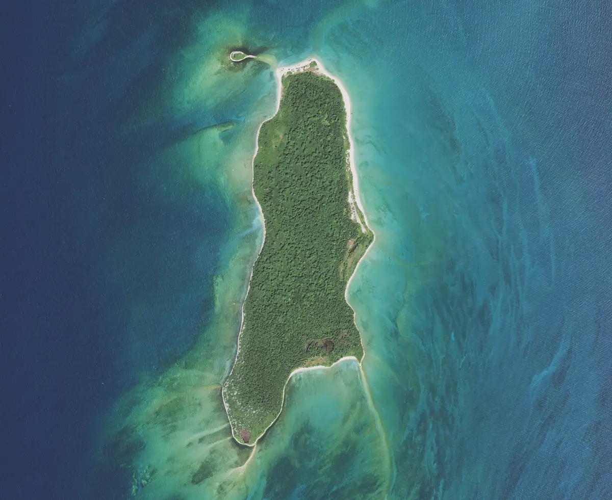
- Beaver Island History Map, 1978 revision · Gull Island and Hog Island bird colonies (film, Gault, ca. 1900-1942) · Gull Island from the air, 2020 · Gull Island from the air, 2020 (detail) · Plats of the outer Beaver Islands, 1930s
Summary
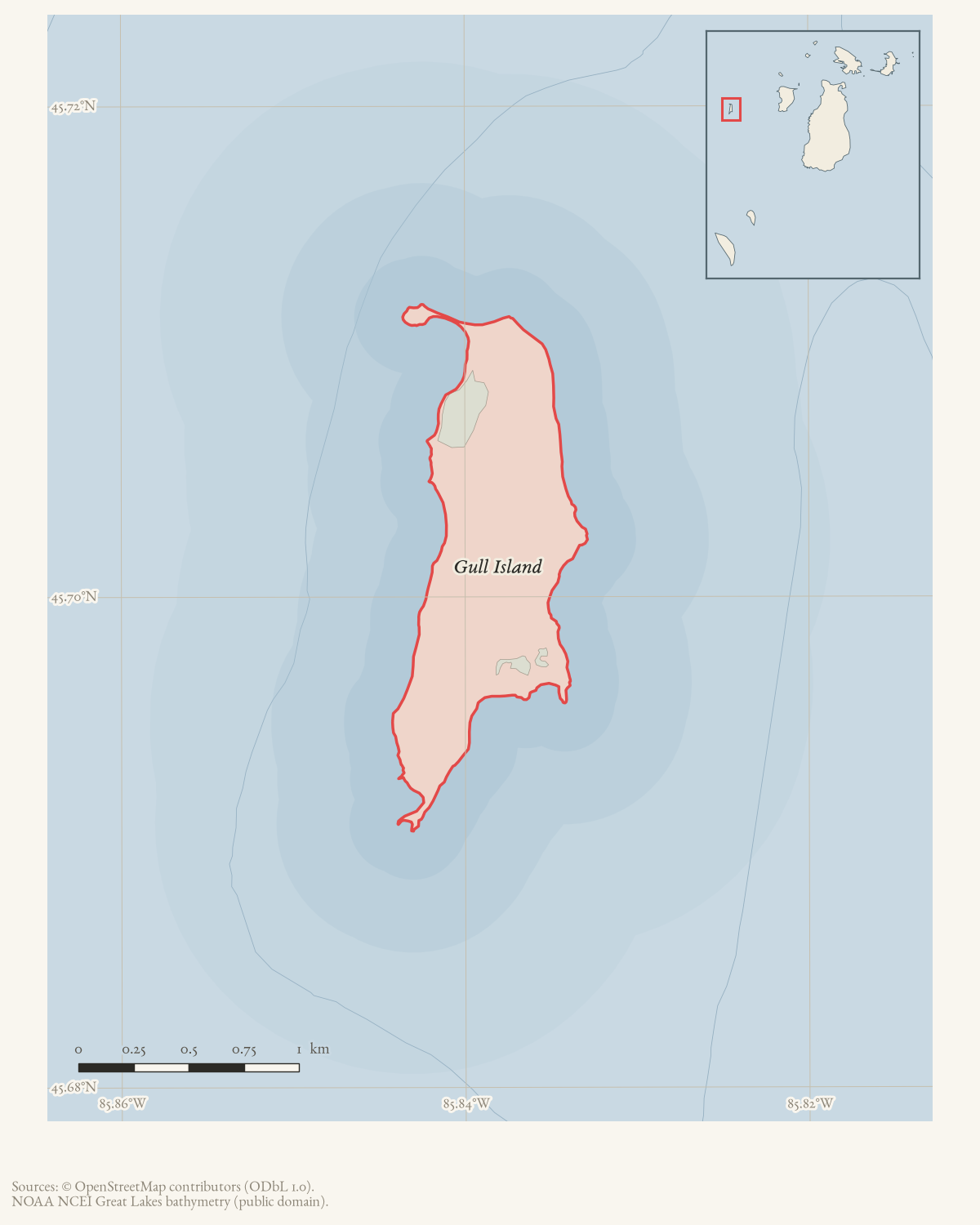
Gull Island is the westernmost island in the Beaver Island group, according to a 1998 Charlevoix Courier account of the Carl D. Bradley disaster. OSM records its island polygon at approximately 1.09 km²; GNIS classifies it as an island.
The 2023 Beaver Island Master Plan places Gull Island within the federally owned Michigan Islands National Wildlife Refuge and lists it among the archipelago’s uninhabited outer islands. The island also appears repeatedly as a maritime reference point. The Courier report says the 615-foot Carl D. Bradley went down about 12 miles off Gull Island on November 18, 1958; it describes the Coast Guard search and rescue, but does not make Gull Island the wreck site. Do not conflate the island’s ecological and navigational significance with the offshore casualty location.
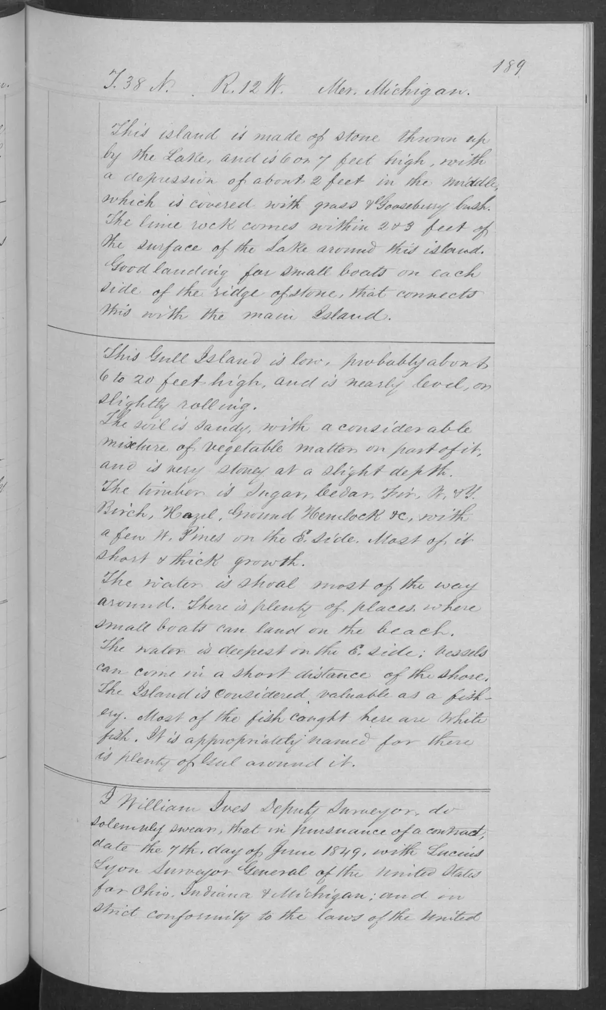
An 1849 GLO field-note description identifies Gull Island as low—about six to twenty feet high—and nearly level to slightly rolling, with sandy soil, a vegetable-matter component, and stone at shallow depth. The surveyor reported shoal water around most of the island, small-boat landing places on the beach, and a whitefish fishery as its principal reported catch. These are bounded mid-19th-century observations, not a present navigational assessment, ecological inventory, or evidence of continuous use.1
The adjacent 1849 meander pages add a more direct human-use record: a log shanty occupied by fishermen, 15 fish houses, a few wigwams, and an estimate of about 20 families and 120–150 people engaged in fishing. The surveyor’s location sequence also records the village itself: the meander post on the section 6/7 line was set “in the Fishermans Village.”
Correction, 12 August 2026. An earlier version of this paragraph said the surveyor’s location page “does not independently identify the village as being on Gull Island.” The page images settle it: page 186 sets the meander post “in the Fishermans Village” on the line between sections 6 and 7 of T38N R12W and has that line intersecting Lake Michigan at 48.30 chains, and page 187 opens “Meanders of Lake Michigan on Gull Island. Beginning at the Meander Corner on the W. end of line between Secs. 6 & 7” — the same line. The fishermen’s village of the 1849 field notes is on Gull Island.
What the 1849 surveyor wrote
The general description is in the hand of William Ives, Deputy Surveyor, working under a contract dated 7 June 1849 with Lucius Lyon, Surveyor General of the United States for Ohio, Indiana and Michigan, on a page headed T. 38 N., R. 12 W., Mer. Michigan. Read from the page image, it says:
This Gull Island is low, probably about 6 to 20 feet high, and is nearly level, or slightly rolling. The soil is sandy, with a considerable mixture of vegetable matter on part of it, and is very stoney at a slight depth. The timber is Sugar, Cedar, Fir, W. & Y. Birch, Hazel, Ground Hemlock &c, with a few W. Pines on the E. Side. Most of it short & thick growth. The water is shoal most of the way around… The water is deepest on the E. Side; vessels can come in a short distance of the shore. The Island is Considered valuable as a fishery. Most of the fish caught here are White fish. It is appropriately named for there is plenty of Gul around it.
So the timber list is sugar maple, cedar, fir, white and yellow birch, hazel and ground hemlock, with a few white pines on the east side, all of it short and thick growth — a wind-exposed island canopy, not the tall stands the surveyors recorded on the larger islands.
Correction, 8 August 2026. This section previously credited Gull Island with “a grassy and gooseberry depression”. On the page image that phrase belongs to a different island. Page 189 carries three rule-separated blocks, and the first describes an unnamed islet “made of stone thrown up by the Lake, and is 6 or 7 feet high, with a depression of about 2 feet in the middle, which is covered with grass & Gooseberry bush”, reached over “the ridge of stone, that connects this with the main Island”. Gull Island’s own block begins under the next rule with “This Gull Island is low”. Different heights, different form, and Gull Island lies miles offshore with no stone ridge to anything. The two descriptions were merged; only the second is Gull Island. The associated meander pages add a small pond separated from Lake Michigan by a stone-and-gravel ridge and a fishermen’s shanty, followed by page-bounded counts of fish houses and fishing families. This connects substrate, low wet ground, vegetation, and fishery use, but does not establish a modern wetland, fish population, bird colony, or complete island-wide ecology.1
Filmed as a bird colony
Some decades after the survey, the island was filmed as a working ornithological site. Benjamin T. Gault shot a silent film on Gull Island and Hog Island for the Chicago Academy of Sciences showing birds over a rocky beach, men banding birds, and a young heron. The Academy dates it no more closely than ca. 1900–1942.
That is not a survey and yields no counts or species list, but it is direct evidence that the island carried a colony substantial enough to be worked and banded — which the 1849 field notes, on their own, do not establish.
Open questions
- What federal refuge records document the acquisition and management history of Gull Island?
- Can the Carl D. Bradley casualty position be reconciled with nautical charts and represented as a separate wreck site or event article?
- Are there bird, nesting, or other ecological surveys for the island itself?
Footnotes
Maps for this place
These Atlas plates provide regional context. They do not establish a precise boundary, current ownership, access right, operating status, or field condition.
- EnvironmentSoils, wetlands, hydrography, and terrain
- GeologyGeneralized geology and landforms
- HydrologyMapped water and wetland context
- AccessMapped routes, facilities, and protected areas
- Land surveyPLSS geometry and historic GLO patent-location context
The dated record
Sources
- Area 1.09 km² computed in EPSG:3078.osm · islands
- GNIS feature 627511; feature class 'Island'.federal · gnis · gnis_names
- Places Gull Island among federally owned islands in the Michigan Islands National Wildlife Refuge and among the uninhabited outer islands of the archipelago.
- Researchers warned that Gull Island is within the Michigan Islands National Wildlife Refuge and quoted the Refuge’s public rules as closing the island to general visitors because of colonial nesting waterbirds. They distinguished offshore observation from landing and identified a special-use-permit process. This archived forum relay points to agency rules but is not itself the controlling legal source.forum · www.beaverislandforum.com · 15 · t015549
- Charlevoix Courier, November 1998, Carl D. Bradley anniversary report.Reports the 1958 loss of the Carl D. Bradley about 12 miles off Gull Island, the Coast Guard rescue operation, and Gull Island’s position as the westernmost island in the Beaver group; it does not locate the wreck at the island. No public copy of this file is known; the archive holds one and can provide it on request.
- Bureau of Land Management, General Land Office Records, Field Note Volume 168138, p. 0189, T38N R12W, 1849.Described in this archive: BLM GLO field-note volumes linked to Beaver Island-area surveys.Visual page-image verification. The original named Gull Island general description records 1849 survey observations: low, nearly level to slightly rolling terrain; sandy, stony soil; observed tree cover; shoal water; small-boat landing places; and the surveyor’s report that whitefish were most commonly caught there. It does not establish current navigation, ownership, full ecology, or a continuous fishery. No public copy of this file is known; the archive holds one and can provide it on request.federal · glo_field_notes · page_evidence · field-note-volume-168138-page-0189-gull-island-general-description
- Bureau of Land Management, General Land Office Records, Field Note Volume 168138, pp. 0187–0188, Gull Island meanders, 1849.Described in this archive: BLM GLO field-note volumes linked to Beaver Island-area surveys.Visual page-image verification. The meander pages record a fishermen's log shanty, 15 fish houses, a few wigwams, and a surveyor-estimated 20 families and 120–150 people engaged in fishing. These are page-bounded observations, not a census, permanent-residence finding, ownership record, or current fishery assessment. No public copy of this file is known; the archive holds one and can provide it on request.federal · glo_field_notes · page_evidence
Added 28 July 2026 · revised 12 August 2026. Recent changes
Cite this article
Beaver Island Archive, “Gull Island”, https://beaverislandarchive.org/places/gull-island/, accessed [date], citing OpenStreetMap contributors, island polygons via Overpass API, retrieved 2026-07-28 (ODbL 1.0). (and 6 further sources listed on the page).
Last revised 2026-08-12. Fill in [date] with the date you read it — this page is static and cannot know that.