

- Dates
- 1845 – 1942
- Eras
- Early American eraModern era
- Concepts
- land-surveyenvironmentforestsgeologywetlandsconservation
- Within
- Beaver Island archipelago
Summary
This context layer connects all 61 visually verified GLO ecology records from 1845–1849 and 1942 to exact BLM PLSS township/range geometry. The records match 13 PLSS townships, including the Fox Island townships T34N R13W (South Fox) and T35N R13W (North Fox), as well as the Beaver, Garden, Hog, High, Ojibwa, Trout, Whiskey, Hat, Shoe, and Pismire contexts.
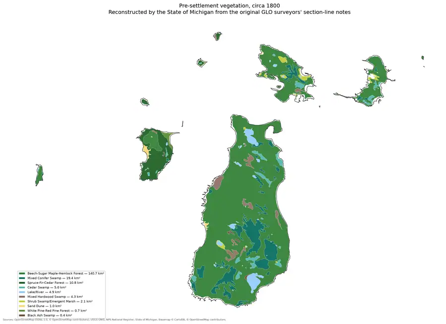
The join is deliberately narrow. Each page retains its own source record, island, date, volume page, and page ID, then receives the matching BLM PLSS feature reference. The output does not copy geometry into the observation record and does not turn a page-bounded survey description into a present-day forest, soil, habitat, parcel, or ownership polygon.
What the field notes record
The 61 joined pages are not abstract metadata; each is a visually verified reading of a General Land Office surveyor’s terrain, timber, and shoreline notes for a specific island, cross-checked against the scanned page image.1 Across the 1845-1849 survey, the most frequently reported tree names are cedar (43 pages), fir (39), sugar maple (38), beech (21), white birch (20), spruce (19), aspen and tamarack (18 each), and hemlock (17), with pine, maple, ironwood, hazel, and several other species recorded less often. Beaver Island itself accounts for 21 of the 57 tree-bearing 1845-1849 pages and the widest species list — including white pine, hemlock, elm, and cherry alongside the more common cedar and maple — while smaller islands such as Hat Island and Gull Island are represented by only one or two species each.1
Individual pages carry specific, dated description. The 1849 Hat Island page records an island “about 6 feet high and nearly level, mostly gravel and small stone washed up by lake swells,” with “brushy cedar growth … 10-30 feet high,” part of which “has been burned.”2 Nearly a century later, the 1942 survey of Shoe Island — one of only four modern-era pages in this join, covering Shoe and Pismire Islands — found no timber and “no indication of former timber,” describing instead “scattered weeds, grass, and small willows” on a low gravel-and-boulder island sloping from about six feet above Lake Michigan on the northwest to about two feet at the southeast point.3 These are page-bounded readings of specific survey visits, not a claim that any island’s vegetation was uniform or unchanged between readings.
What the section context means
The held section layer makes it possible to see which island-intersected PLSS
sections are available inside each matched township. Those section numbers are
reported as candidate spatial context only. The retained ecology records
usually identify a township/range and a page-bounded survey operation, not a
single section. Consequently, the artifact marks every record
assignment_status: not_resolved_from_source_record rather than guessing from
page order or nearby text.
This distinction matters most for combined or fractional-island descriptions: the Garden/Hog page remains a combined source record, and the same township can contain records for multiple islands. T40N R8W also has two returned township geometry features in the BLM response; both are preserved in the context layer.
Use in maps and later joins
The PLSS township geometry is now a safe cartographic frame for showing where a GLO observation belongs at township/range scale. A map may symbolize records by island, year, source page, tree terms, shore material, wetlands, disturbance, or bird observation and link back to the evidence image. It should not draw an ecology boundary around the township or imply that every candidate section shares the page’s reported conditions.
The layer can support a later, higher-resolution pass over GLO pages that explicitly state section numbers. Such records can be joined to PLSS sections only when the section wording and page evidence are retained together. Current soil, forest-inventory, NLCD, and MNFI context remains at its own documented scale; this artifact does not claim EO-to-pixel, stand-to-page, or soil-series overlap.
The current explicit-section companion implements that rule for 31 claims: 30 exact PLSS matches and one documented missing-geometry case, represented by 25 unique map polygons.
See also
- Visually verified GLO survey observations of archipelago soils, terrain, and trees, 1845–1849
- Visually verified GLO modern island ecology observations, 1942
- BLM GLO field-note volumes linked to Beaver Island-area surveys
- General Land Office survey plats for the Beaver Island archipelago
- Land survey and settlement geography
- Forest types and tree history
- Geology and landforms
Footnotes
-
Project-generated visually verified GLO ecology crosswalk for the Beaver Island archipelago, 1845-1849,
data/research/land_cover/crosswalks/glo_ecology_crosswalk_1845_1849.json. ↩ ↩2 -
GLO field note volume 168138, p. 6, Hat Island general description, 1849; crosswalk record
glo-168138-p0006-hat-1849. ↩ -
GLO field note volume 276017, p. 762, Shoe Island general description, 1942; crosswalk record
glo-276017-p0762-shoe-1942,data/research/land_cover/crosswalks/glo_modern_ecology_1942.json. ↩
Sources
- Project-generated GLO ecology/PLSS context crosswalk, 61 visually verified GLO records joined to 13 BLM PLSS township/range labels.The machine-readable artifact retains source record IDs, page IDs, exact township feature references, and available AOI-intersected section context. It does not assign an observation to a section or infer an ecological polygon. No public copy of this file is known; the archive holds one and can provide it on request.research · land_cover · crosswalks · glo_ecology_plss_context_1845_1942
- Held GeoJSON layers are public-domain geometry retrieved for the archipelago bounds. Township/range is the exact join key; section and aliquot layers are retained as map context.federal · plss
- The source pages remain the evidence for the ecological readings. BLM provider OCR is discovery-only.research · land_cover · crosswalks
- Project-generated explicit-section GLO/PLSS context crosswalk, 1847–1849.Resolves 30 explicit source sections to held PLSS geometry and records Hat §28 as an explicit source claim whose feature is outside the held AOI-clipped section slice. No public copy of this file is known; the archive holds one and can provide it on request.research · land_cover · crosswalks · glo_explicit_section_context_1847_1849
- Project-generated exact-section map derivative for the explicit GLO claims.Map-ready geometry for the 25 unique exact section matches only; the unresolved Hat §28 claim remains in the JSON evidence layer. No public copy of this file is known; the archive holds one and can provide it on request.research · land_cover · crosswalks · glo_explicit_section_context_1847_1849
- Per-island tree-name lists and frequency counts (e.g. cedar on 43 of 57 tree-bearing pages, fir on 39, sugar maple on 38) and individual page-level land, soil, wetland, and disturbance readings, each tied to a source page image and volume/page number. The holder's public portal is searchable but does not link this record directly; the archive holds a copy of the file and can provide it on request.research · land_cover · crosswalks · glo_ecology_crosswalk_1845_1849
- Project-generated visually verified GLO modern ecology crosswalk for Shoe and Pismire Islands, 1942.Four page-level 1942 survey readings, including the Shoe Island description of a treeless gravel-and-boulder island with scattered weeds, grass, and small willows. The holder's public portal is searchable but does not link this record directly; the archive holds a copy of the file and can provide it on request.research · land_cover · crosswalks · glo_modern_ecology_1942
Added 3 August 2026. Recent changes
Cite this article
Beaver Island Archive, “GLO ecology observations joined to PLSS context, 1845–1942”, https://beaverislandarchive.org/documents/glo-ecology-plss-context-1845-1942/, accessed [date], citing Project-generated GLO ecology/PLSS context crosswalk, 61 visually verified GLO records joined to 13 BLM PLSS township/range labels. (and 6 further sources listed on the page).
Last revised 2026-08-03. Fill in [date] with the date you read it — this page is static and cannot know that.
BibTeX for “GLO ecology observations joined to PLSS context, 1845–1942”RIS for “GLO ecology observations joined to PLSS context, 1845–1942”