

- Coordinates
- 45.8158° N, 85.3001° WGoogle Maps: Hat IslandDownload KML
- Eras
- Modern era
- Concepts
- environmentgeologysoilsforestsvegetationtreeswildlifebirdsconservationtourismmilitarymaritimeshipping
- Within
- Beaver Island archipelago
- Media
- Plats of the outer Beaver Islands, 1930s
Summary
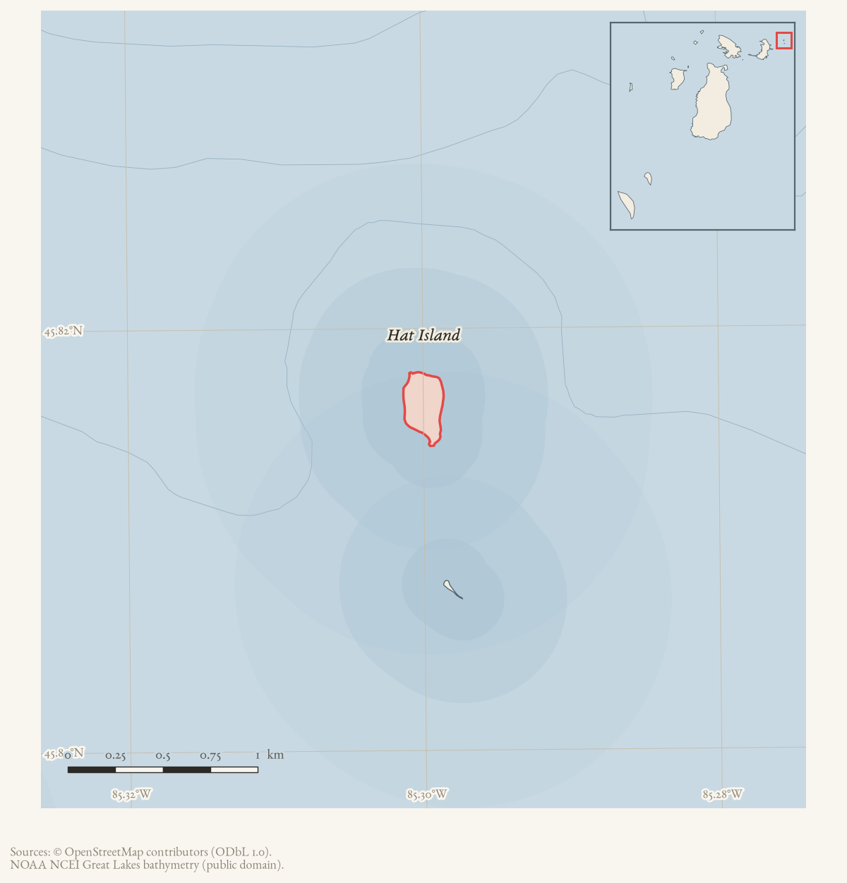
Hat Island is a small, uninhabited outer island of the Beaver Island archipelago, GNIS feature 627929, 0.06 km² (EPSG:3078), located east of Hog Island and north of Garden Island.12 An 1849 federal land survey found it a low gravel islet with scattered cedar; by the twentieth century it had served, in turn, as a mail-route waypoint, a small-scale log-towing operation, a disputed tax title, a private hideaway advertised for sale, a U.S. Navy high-altitude bombing target, and — from around 1980 — a unit of the Michigan Islands National Wildlife Refuge, valued for one of the largest Caspian tern colonies in the Great Lakes.34
Geography and the 1849 survey
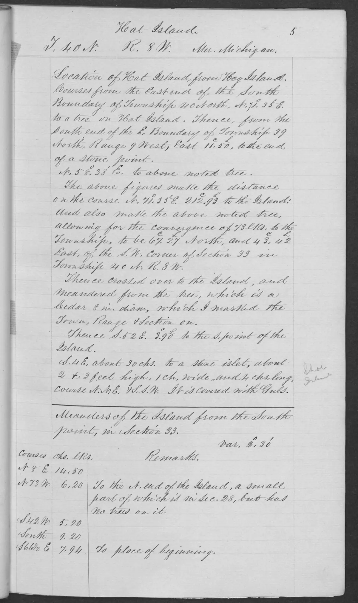
An 1849 federal survey describes Hat Island as about ten feet high and nearly level, mostly gravel and small stone washed by Lake Michigan swells. It recorded cedar 10–30 feet high, part of it burned; a gravel-and-stone base 50–200 yards wide; and a good boat landing around most of the island. These are dated survey observations, not statements of current conditions, title, ownership, or access.5 The same 1849 survey page labels a nearby stone islet “Shoe.” A held 1942 survey of Shoe Island explicitly refers back to that Hat Island field-note connection; see GLO field-note pages: Hat Island survey, 1849 and GLO field-note pages: Shoe Island survey, 1942. A 2010 U.S. Army Corps of Engineers notice records the island’s area as 12 acres and its position as two miles east of Hog Island and 27.8 miles west of Mackinaw City.3
Route, industry, and disputed title, 1888-1962
Long before any conservation or defense use, Hat Island appears repeatedly as a waypoint and small industrial site. An undated but likely 1887-88 Charlevoix Sentinel item reports “two Indians” carrying the first mail in forty days from Beaver Island by dog team over lake ice “by way of Hog Island, Hat Island and Waugochance,” with ice reported three to ten inches thick.6 A castaway story from the same period tells of “N. Phillips, of Grand Rapids,” whose small boat broke loose and drifted away while he was ashore on “Hat Island (uninhabited)”; stranded several days without food, he built a raft from boards he found and was rescued nearly exhausted, in the track of passing vessels.7 In September 1941 the Charlevoix Courier reported Capt. Geo. Wenver’s purchase of the tug Fred Drews, rebuilt to tow logs from Hat Island to Cross Village the following spring, evidence of a small logging operation staged from the island.8
In February 1925 a letter to the Charlevoix Sentinel, later reprinted in the Beacon’s “Beaver Tales” column, logged what its four authors — W. J. “Willie John” Gallagher, Tom Gatliff, Joe Floyd, and Mat Melville — called the first automobile trip from Beaver Island to Cross Village, driven on lake ice in a 1912-model Ford. Crossing the north end of Garden Island, the car reached Hat Island’s north side and followed mail-carrier tracks to a beach where the carriers fed their horses — “the first car that ever was on Hat Island” — before continuing to Cross Village in three hours twenty minutes.9
By the early 1960s the island’s ownership had become legally contested. A March 1962 Charlevoix Courier legal notice records a Michigan Tax Title Service Bureau chancery suit to quiet title on “Fractional Section 33… also known as Hat Island,” naming Champ Williams, J. A. T. Wendell, and several other named and unknown heirs as defendants, with an order for appearance entered by Circuit Judge Charles L. Brown on 29 November 1962.10 By 1974 the island was advertised for sale at $35,000 for its 11 acres, the same price and wording repeated in a 1975 notice.1112
Federal acquisition and the Hat Island bombing target
By November 1979 the federal government, through its Wildlife Ecosystem Program, was making overtures to purchase or lease the island — then owned by Edwin Jakeway of Grand Blanc — specifically to “preserve and protect” its nesting bird colonies. The Charlevoix Courier reported that Hat Island’s Caspian tern colony had produced 43 percent of all Caspian tern nests in the U.S. Great Lakes region in 1976 and 1977, and that herring gulls, great blue herons, and migrating songbirds, shorebirds, raptors, and waterfowl also used the island; Hat Island was named alongside Harbor, Gravelly, Gull, and Little Gull Islands as targets of the same acquisition program.4 This 1979 report is the latest dated evidence found here of the transition from private to federal ownership; no source read records the acquisition’s completion date.
A 2010 Army Corps of Engineers site-inspection notice adds a starkly different chapter: between 1943 and 1945, the U.S. Naval Air Station at Traverse City used the “Former Hat Island Target” for high-altitude bomb tests, including early heat-seeking and radio-controlled weapons. Training ended in October 1945; the Navy terminated its leases in June 1946 and continued periodic inspections through 1951, with warning signs posted. The notice confirms the island is now part of the Michigan Islands National Wildlife Refuge, and solicited public information as part of a formal environmental site inspection.3 No source held here reconciles the wartime bombing-range period with the 1962 tax-title dispute or the 1974 and 1975 private sale advertisements, all of which fall after the range’s stated 1946 lease termination.
Ecological profile
Hat Island’s 1849 profile is primarily a shoreline and disturbance observation: the island was about ten feet high and nearly level, with gravel and small stone washed by Lake Michigan swells, a broad gravel-and-stone base, and cedar roughly 10–30 feet high. Part of the cedar growth was burned, and one survey reference point had no tree. The same page says a nearby low stone islet was covered with gulls; that bird observation is retained as source-bounded context and is not used to infer a colony size, nesting status, or modern boundary. The page therefore supports geology, thin-soil, vegetation, tree, fire, and bird links, but not a current habitat inventory.5
More than a century later, the island’s bird colonies became individually documented. A July 1961 Beacon report on regional bird-banding work recorded that a Caspian tern banded on Hat Island on 5 July 1960 — before it could fly — was found on an ocean beach at Columbia, South Carolina, three months and eighteen days later, evidence of the long-distance dispersal of birds hatched on the island.13 By the time of the 1979 federal acquisition interest, the island’s Caspian tern colony was reported producing 43 percent of all Caspian tern nests in the U.S. Great Lakes region during 1976 and 1977, alongside herring gulls, great blue herons, and migratory songbirds, shorebirds, raptors, and waterfowl.4
Significance
Hat Island is small enough to have no year-round population and no single defining use, but the held record shows it drawn into a striking range of larger stories: a nineteenth-century mail and travel corridor, a working logging operation, a contested land title, a private real-estate listing, one of the Great Lakes’ most productive Caspian tern colonies, and a formerly secret U.S. Navy bombing range now folded into a National Wildlife Refuge. Few of these threads connect to one another in the sources gathered here; the island’s significance is cumulative rather than singular.
Open questions
- When did federal refuge ownership formally begin, and how did it relate to the 1974-75 private sale advertisements and the disputed 1962 tax title?
- Can the mail route and horse-feeding area described in the 1925 auto-trip log be located on historical maps or plat records?
- Are there additional bird-banding records for Hat Island in federal wildlife datasets, beyond the single 1960 Caspian tern recovery reported in 1961?
- What was the outcome of the 1962 chancery suit to quiet title against Champ Williams and the other named defendants?
- Does any Navy or Army Corps record give a precise location, extent, or ordnance inventory for the 1943-45 bombing target, beyond the 2010 site- inspection notice’s summary?
- Can the circa-1887-88 Sentinel items (the dog-team mail route and the N. Phillips castaway story) be dated precisely from an intact masthead?
See also
Footnotes
-
U.S. Geological Survey, Geographic Names Information System, Domestic Names (Michigan), retrieved 2026-07-28 (
data/federal/gnis/gnis_names.geojson), feature 627929. ↩ -
OpenStreetMap contributors, island polygons via Overpass API, retrieved 2026-07-28 (ODbL 1.0) (
data/osm/islands.geojson); area 0.06 km² computed in EPSG:3078. ↩ -
Charlevoix Courier, November 14, 1979, “Government interested in Hat Island.” ↩ ↩2 ↩3
-
Bureau of Land Management, General Land Office Records, Field Note Volume 168138, pp. 0005–0006, T40N R8W, 9 July 1849. ↩ ↩2
-
Charlevoix Sentinel, circa 1887-1888, mail-route report. ↩
-
Charlevoix Sentinel, circa 1887-1888, “Words by Wire” news column. ↩
-
Charlevoix Courier, September 10, 1941, marine notes. ↩
-
Beaver Beacon, December 1963, “Beaver Tales: First Auto Trip From Beaver Island,” reprinting a February 25, 1925 letter to the Charlevoix Sentinel. ↩
-
Charlevoix Courier, March 8, 1962, legal notice. ↩
-
Charlevoix Courier, 1974, classified/property notice. ↩
-
Charlevoix Courier, 1975, classified/property notice. ↩
-
Beaver Beacon, July 1961, “Bird Banding.” ↩
Maps for this place
These Atlas plates provide regional context. They do not establish a precise boundary, current ownership, access right, operating status, or field condition.
- EnvironmentSoils, wetlands, hydrography, and terrain
- GeologyGeneralized geology and landforms
- HydrologyMapped water and wetland context
- AccessMapped routes, facilities, and protected areas
- Land surveyPLSS geometry and historic GLO patent-location context
The dated record
Sources
- Area 0.06 km² computed in EPSG:3078.osm · islands
- GNIS feature 627929; feature class 'Island'.federal · gnis · gnis_names
- Places Hat Island among federally owned islands in the Michigan Islands National Wildlife Refuge and among the uninhabited outer islands of the archipelago.
- Reports a Caspian Tern banded on Hat Island on July 5, 1960 and describes the broader gull and tern banding work around Beaver Island.data1 · beaver-island-archive · beaver_beacon · 1961-07_Beaver-Beacon
- The held seven-page issue scan is paired with the OCR source and confirms the published notice or report; it does not expand the source-specific identity, event, or outcome claims.data1 · beaver-island-archive · scans · beaver_beacon · issues · 1961-07_Beaver-Beacon
- Describes an over-ice trip from Beaver Island to the Hat’s north side, where the travelers followed mail-carrier tracks to the beach and noted horse feeding there.data1 · beaver-island-archive · beaver_beacon · 1963-12_Beaver-Beacon
- The held nine-page issue scan is paired with the OCR source and confirms the published notice or report; it does not expand the source-specific identity, event, or outcome claims.data1 · beaver-island-archive · scans · beaver_beacon · issues · 1963-12_Beaver-Beacon
- Charlevoix Courier, 1975, classified/property notice.Advertises Hat Island for sale for $35,000, documenting private ownership or marketing at that date; the notice does not establish a completed sale. No public copy of this file is known; the archive holds one and can provide it on request.
- Bureau of Land Management, General Land Office Records, Field Note Volume 168138, pp. 0005–0006, T40N R8W, 9 July 1849.Described in this archive: BLM GLO field-note volumes linked to Beaver Island-area surveys.Visual page-image verification. The handwritten original identifies Hat Island and describes an 1849 survey: it was about ten feet high and nearly level, mostly gravel and small stone washed by Lake Michigan swells, with cedar 10–30 feet high and partly burned. It records a 50–200-yard gravel-and-stone base and a good boat landing around most of the island. These are time-bounded observations, not current habitat, ownership, title, or access claims. No public copy of this file is known; the archive holds one and can provide it on request.federal · glo_field_notes · page_evidence · field-note-volume-168138-page-0005-hat-island-survey
- Described in this archive: GLO field-note pages: Hat Island survey, 1849.The checked survey page identifies a nearby stone islet as “Shoe”; the relation is retained as a dated source record and is not used to infer title, a present boundary, or current condition.federal · glo_field_notes · page_evidence · field-note-volume-168138-page-0005-hat-island-survey
- Described in this archive: Visually verified GLO survey observations of archipelago soils, terrain, and trees, 1845–1849.Adds page-level records for gravel/stone, cedar, burning, and the nearby stone islet covered with gulls, preserving the 1849 source-bounded observation used by the later Shoe survey. The holder's public portal is searchable but does not link this record directly; the archive holds a copy of the file and can provide it on request.research · land_cover · crosswalks · glo_ecology_crosswalk_1845_1849
- Read directly. Reprints a letter dated February 25, 1925, to the Charlevoix Sentinel from W. J. "Willie John" Gallagher, Tom Gatliff, Joe Floyd, and Mat Melville, logging what they call the first automobile trip from Beaver Island to Cross Village, on lake ice, in a 1912-model Ford ("the first car brought to the Island"). The car crossed the north end of Garden Island, then Hat Island's north side, following mail-carrier tracks to a beach where the carriers fed their horses -- "the first car that ever was on Hat Island." The trip took 3 hours 20 minutes outbound. The 1912 model year describes the car, not necessarily the year of the trip, which the letter's own internal reference to "last fall" places closer to its 1925 date.data1 · beaver-island-archive · beaver_beacon · 1963-12_Beaver-Beacon
- Charlevoix Sentinel, circa 1887-1888, "Words by Wire" news column.Reprints a Harbor Springs Republican item, credited to Capt. Bonchard of the steamer Cummings, reporting that "N. Phillips, of Grand Rapids," landed at "Hat Island (uninhabited)" from a small boat, which then broke loose and drifted to Cross Village; Phillips was stranded several days without food, built a raft from boards found on the island, and was rescued nearly exhausted. The bound-volume file does not carry a masthead date immediately at this item; nearby dated content in the same file runs October-November 1887, so the date is recorded here as approximate. No public copy of this file is known; the archive holds one and can provide it on request.data1 · beaver-island-archive · charlevoix · charlevoixsentin0506unse
- Charlevoix Sentinel, circa 1888, mail-route report.Reprints a Milwaukee Wisconsin correspondent's dispatch from Cross Village, dated internally "February 14th" (year not confirmed against a nearby masthead), reporting that "two Indians came from Beaver Island with a dog team... by way of Hog Island, Hat Island and Waugochance," carrying the first mail in forty days, over ice reported three to ten inches thick. No public copy of this file is known; the archive holds one and can provide it on request.data1 · beaver-island-archive · charlevoix · charlevoixsentin0321unse
- Charlevoix Courier, September 10, 1941, marine notes.Reports Capt. Geo. Wenver purchasing the tug Fred Drews to rebuild and use towing logs from Hat Island to Cross Village the following spring -- evidence of a small-scale logging operation on or staged from the island. No public copy of this file is known; the archive holds one and can provide it on request.data1 · beaver-island-archive · charlevoix · charlevoixcourie0628unse
- Charlevoix Courier, March 8, 1962, legal notice.Read directly. A Michigan Tax Title Service Bureau chancery suit to quiet title on "Fractional Section 33... also known as Hat Island," Township 40 North, Range 8 West, against Champ Williams, J. A. T. Wendell, Champion Williams, Orin A. Kates, Orine A. Werner, Helen L. Morningstar, and unknown heirs; order for appearance entered November 29, 1962 by Circuit Judge Charles L. Brown. Evidence of contested or lapsed title in the early 1960s, predating the 1970s sale advertisements and 1979 federal acquisition interest. No public copy of this file is known; the archive holds one and can provide it on request.data1 · beaver-island-archive · charlevoix · charlevoixcourie0308unse
- Charlevoix Courier, 1974, classified/property notice.Advertises "HAT ISLAND 11 ACRES... $35,000," identical wording and price to the 1975 notice below; the two attest the same asking price across at least two years, not necessarily two separate listings. No public copy of this file is known; the archive holds one and can provide it on request.data1 · beaver-island-archive · charlevoix · charlevoixcourie1974unse
- Charlevoix Courier, November 14, 1979, "Government interested in Hat Island."Read directly. Reports the federal government, through its Wildlife Ecosystem Program, making overtures to purchase or lease the 11-acre island, then owned by Edwin Jakeway of Grand Blanc, Michigan, to "preserve and protect" its wildlife. States the island's Caspian tern colony produced 43 percent of all Caspian tern nests in the U.S. Great Lakes region during 1976 and 1977, and that herring gulls, great blue herons, and migrating songbirds, shorebirds, raptors, and waterfowl also use it. Hat Island is named alongside Harbor, Gravelly, Gull, and Little Gull Islands as targets of the same federal program. No public copy of this file is known; the archive holds one and can provide it on request.data1 · beaver-island-archive · charlevoix · charlevoixcourie1979unse
- Charlevoix Courier, 2010, "Request for information about the Former Hat Island Target."Read directly. A U.S. Army Corps of Engineers site-inspection notice states that the 12-acre "Former Hat Island Target," two miles east of Hog Island, was used between 1943 and 1945 by the U.S. Naval Air Station at Traverse City for high-altitude bomb tests, including early heat-seeking and radio-controlled weapons; training ended October 1945, the Navy terminated its leases in June 1946, and periodic inspections continued through 1951 with warning signs posted. States the island is now part of the Michigan Islands National Wildlife Refuge. No public copy of this file is known; the archive holds one and can provide it on request.data1 · beaver-island-archive · charlevoix · charlevoixcourie2010unse
Added 28 July 2026 · revised 4 August 2026. Recent changes
Cite this article
Beaver Island Archive, “Hat Island”, https://beaverislandarchive.org/places/hat-island/, accessed [date], citing OpenStreetMap contributors, island polygons via Overpass API, retrieved 2026-07-28 (ODbL 1.0). (and 17 further sources listed on the page).
Last revised 2026-08-04. Fill in [date] with the date you read it — this page is static and cannot know that.