

- Coordinates
- 45.7719° N, 85.6904° WGoogle Maps: Trout IslandDownload KML
- Eras
- Modern era
- Concepts
- environmentgeologysoilsforestsvegetationtreeswetlandsfishingtourismmaritime
- Within
- Beaver Island archipelago
- Media
- Plats of the outer Beaver Islands, 1930s
Summary
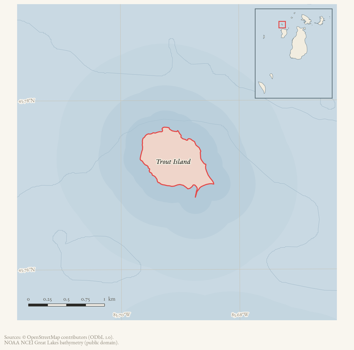
Trout Island is a small (0.50 km²) island northwest of High Island in the Beaver Island archipelago. An 1849 federal land survey found it seasonally used for fishing, with old fish shanties and vacant wigwam frames on its shore. It remained largely undeveloped until a private landing-strip and lot development began in the late 1960s, and it is privately owned and not open to the public today.
History
A reprinted Charlevoix Sentinel item of May 25, 1905, carried in a later Beaver Beacon “years ago” column, reports that “the U.S. Steamer Survey is in port, having finished up the survey of Trout Island and Simmon’s reef” — a federal hydrographic survey distinct from the 1849 GLO land survey below. In September 1955 a Conservation Department patrol boat under Chet Belfy responded to a fire on Trout Island; the fire had burned underground without spreading and its cause, possibly lightning, was undetermined.
The island’s modern development history is documented in two Beaver Beacon reports. In May 1968, the paper reported that Henry Allen had begun developing the island, with lake-shore lots planned and a landing strip proposed. In September 1970, it reported that Allen and his sons had worked on the strip for two years, that the island had been divided into ten-acre parcels, and that Emory Griffin had begun a 28-by-40-foot house on the first parcel. The latter article characterized Trout Island as having been uninhabited for many years; that is retained as a dated local description, not treated as a complete settlement history.
A first-person account by pilot Paul Welke, published in the Beacon’s “The View from Five Hundred Feet” series in April 2008, describes responding by air to a reported fire on Trout Island one Sunday in the early 1990s. Welke found an accessory building ablaze beside “the only house” on the island, used by a family who fought the fire with a garden hose from their well before he shut off external fuel-oil tanks feeding the flames; the owner, in a dispute with the state over property taxes on the grounds that Trout Island received none of the township services other residents did, declined the Beaver Island Fire Department’s help even as it stood ready at Welke Airport. The accessory building was lost; the house and its cedar shingles survived, though embers later ignited three nearby cedar stumps. The account independently confirms the island’s rough airstrip and the presence of at least one year-round or seasonal household there by the early 1990s, two decades after the Allen development notices.
By 2009 and 2013, community discussion on the Beaver Island Forum confirmed that the cleared strip visible from the air was the island’s airstrip, and a caretaker, Paul Welke, stated directly that Trout Island and its grass airstrip were privately owned and not open for public use.
1849 field survey
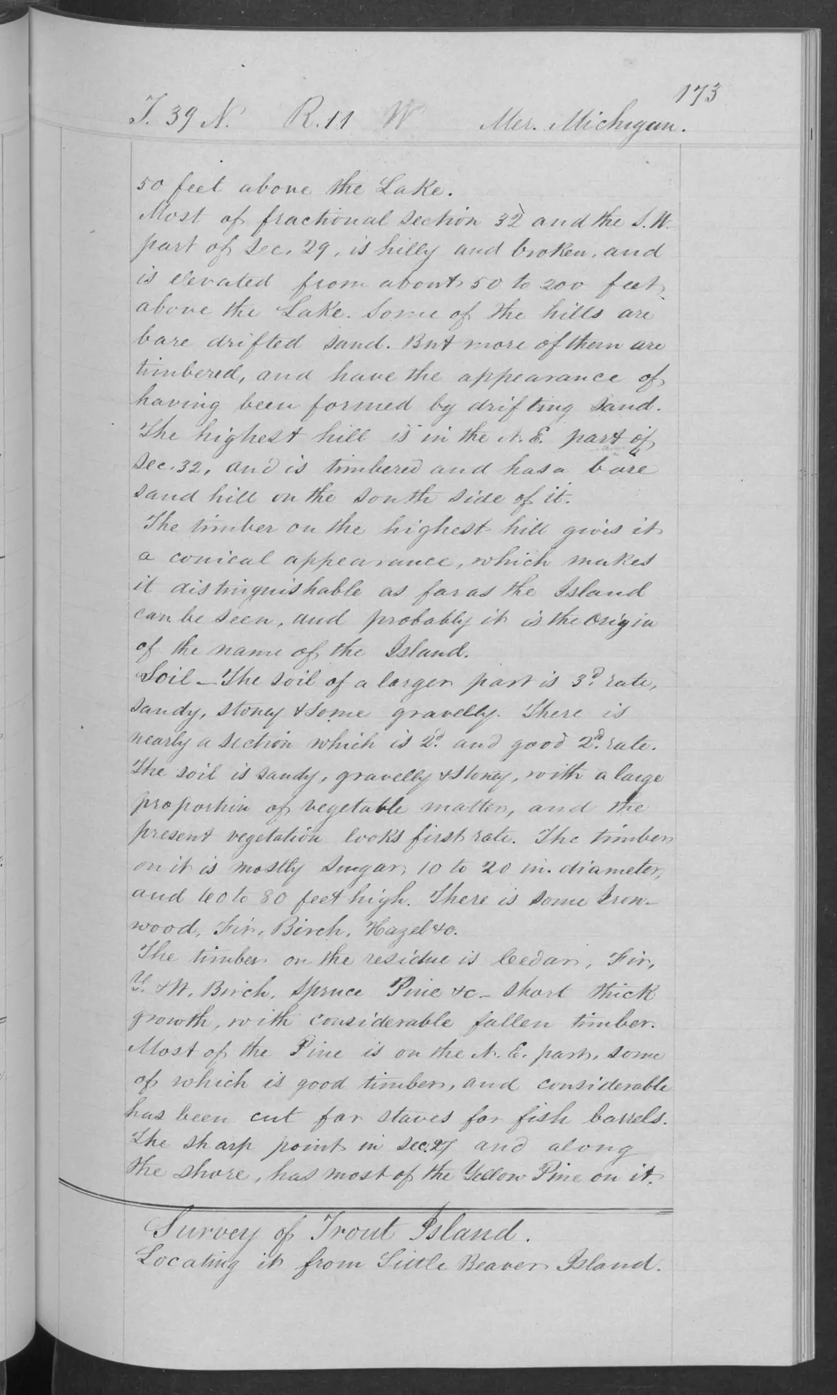
The original 1849 GLO notes explicitly begin a “Survey of Trout Island.” The surveyor recorded five or six old fish shanties and an equal number of vacant wigwam frames, using the period terminology of the record. That observation is evidence of structures at the time of survey, not of their builders, occupants, tribal affiliation, land rights, or duration of use.1
The survey’s general description calls the island nearly level but wet and swampy in places, mostly stony in low lake-formed ridges, with a narrow stony and gravelly beach. It notes a small sand hill on the north side, a short growth of fir, cedar, white birch, and spruce, and a considerably higher northern hill with good timber, some of it cut for staves used in fish boats. These are strictly bounded 1849 observations rather than a description of current ecology or access.
Ecological profile
The Trout Island pages preserve a useful contrast between substrate, wet ground, and timber quality. The survey records drifted-sand hills, mostly third-rate sandy, stony, and gravelly ground, and a better section rich in vegetable matter with large sugar timber. The lower portion was nearly level, wet or swampy in places, and marked by lake-formed stone ridges and thin soil; its short growth included fir, cedar, white birch, and spruce, with pine also named in the broader sequence. Timber cut for fish-boat staves and the page-0174 fish shanties and vacant wigwam frames show how the survey landscape intersected with fishing use. These are route- and page-bounded observations, not a modern forest inventory, wetland boundary, complete plant list, or current occupation finding.1
Open questions
- Did the proposed landing strip become operational, and how long did the parcel development continue?
- Which earlier Indigenous, fishing, logging, or seasonal uses are documented in maps, newspapers, or land records?
See also
Footnotes
Maps for this place
These Atlas plates provide regional context. They do not establish a precise boundary, current ownership, access right, operating status, or field condition.
- EnvironmentSoils, wetlands, hydrography, and terrain
- GeologyGeneralized geology and landforms
- HydrologyMapped water and wetland context
- AccessMapped routes, facilities, and protected areas
- Land surveyPLSS geometry and historic GLO patent-location context
The dated record
Sources
- Paul Welke, identifying himself as the caretaker, stated that Trout Island and its grass airstrip were privately owned and not open for public use. This is a contemporaneous caretaker statement, not a deed, FAA airport record, surveyed access restriction, or independent title search.forum · www.beaverislandforum.com · 05 · t005924
- A community discussion identifies the conspicuous cleared strip as an airstrip, based partly on an overflight recollection, and repeats that Trout Island is privately owned. The discussion is weaker than the later caretaker statement and does not establish the strip's date, legal status, dimensions, or aviation authorization.forum · www.beaverislandforum.com · 01 · t001451
- Area 0.50 km² computed in EPSG:3078.osm · islands
- Reports Henry Allen's proposed lake-shore lot development and landing strip on Trout Island.data1 · beaver-island-archive · beaver_beacon · 1968-05_Beaver-Beacon
- The held eight-page issue scan is paired with the OCR source and confirms the published notice or report; it does not expand the source-specific identity, event, or outcome claims.data1 · beaver-island-archive · scans · beaver_beacon · issues · 1968-05_Beaver-Beacon
- Reports a landing strip under development, ten-acre parcels, the first home under construction, and the local description that the island had been uninhabited for many years.data1 · beaver-island-archive · beaver_beacon · 1970-09_Beaver-Beacon
- The held seven-page issue scan is paired with the OCR source and confirms the published notice or report; it does not expand the source-specific identity, event, or outcome claims.data1 · beaver-island-archive · scans · beaver_beacon · issues · 1970-09_Beaver-Beacon
- Described in this archive: GLFC guide for Lake Michigan lake-trout rehabilitation, 2008.Defines a modern West Beaver Group that includes Trout Island. This is a lake-trout rehabilitation grouping, not a claim about the island’s historical name, ownership, or use.geology · publications · glfc_2008_lake_trout
- Bureau of Land Management, General Land Office Records, Field Note Volume 168138, pp. 0173–0175, T39N R11W, Trout Island survey and general description, 1849.Described in this archive: GLO field-note pages: Trout Island survey, 1849.Visual page-image verification. The original survey identifies Trout Island and records 1849 fish shanties and vacant wigwam frames, shoreline and landing observations, relief, soil, vegetation, and timber cut for fish-boats. These are time-bounded observations, not claims about modern community membership, tribal affiliation, ownership, title, access, or current habitat. No public copy of this file is known; the archive holds one and can provide it on request.federal · glo_field_notes · page_evidence · field-note-volume-168138-page-0173-trout-island-survey
- Described in this archive: Visually verified GLO survey observations of archipelago soils, terrain, and trees, 1845–1849.Includes the Trout pages 0173–0175 as separate bounded records, including page 0174 fish-shanty and vacant-wigwam-frame observations. The holder's public portal is searchable but does not link this record directly; the archive holds a copy of the file and can provide it on request.research · land_cover · crosswalks · glo_ecology_crosswalk_1845_1849
- Project-generated explicit GLO section references joined to PLSS context.Described in this archive: Explicit GLO section references joined to PLSS context, 1847–1849.Carries Trout page 0174 section references §§17, 28, and 29; all three match held PLSS section geometry. No public copy of this file is known; the archive holds one and can provide it on request.research · land_cover · crosswalks · glo_explicit_section_context_1847_1849
- Charlevoix Sentinel, May 25, 1905, "Beaver Island News," reprinted in Beaver Beacon, May 2005.Reprinted 1905 item reports the U.S. Steamer Survey finishing a survey of Trout Island and Simmon's Reef. No public copy of this file is known; the archive holds one and can provide it on request.data1 · beaver-island-archive · beaver_beacon · 2005-05_Beaver-Beacon
- Reports a Conservation Department patrol boat, under Chet Belfy, responding to a fire on Trout Island on September 22, 1955, that burned underground without spreading; cause undetermined, possibly lightning. The holding institution's portal restricts automated access; the archive holds a copy of this issue and can provide it on request.data1 · beaver-island-archive · beaver_beacon · 1955-10_Beaver-Beacon
- Paul Welke, "Pilots really do get days off," "The View from Five Hundred Feet," Beaver Beacon, April 2008.First-person account of responding by air to a fire on Trout Island in the early 1990s: an accessory building burned beside "the only house" on the island, the owner's family fought it with a garden hose, and the owner refused Beaver Island Fire Department assistance due to a property-tax dispute over township services. Confirms the airstrip and at least one household on the island by that period. No public copy of this file is known; the archive holds one and can provide it on request.data1 · beaver-island-archive · beaver_beacon · 2008-04_Beaver-Beacon
Added 28 July 2026 · revised 5 August 2026. Recent changes
Cite this article
Beaver Island Archive, “Trout Island”, https://beaverislandarchive.org/places/trout-island/, accessed [date], citing Paul Welke and participants, “Trout Island Airport,” Beaver Island Forum, January 7–8, 2013, topic 5924. (and 13 further sources listed on the page).
Last revised 2026-08-05. Fill in [date] with the date you read it — this page is static and cannot know that.