

- Along road
- Pat's Road
- Coordinates
- 45.5861° N, 85.5279° WGoogle Maps: Cable BayDownload KML
- Eras
- Irish eraModern era
- Concepts
- toponymyfishinglumberingtourismenvironmentgeologysoilsdunesvegetationplantstreeswildlifeanimalsconservationstewardshipinvasive-speciesmigrationsettlement
- Within
- Beaver Island
- Media
- Beaver Island History Map, 1978 revision · General highway map of Charlevoix County, 1965 · Plat of Big Beaver Island, 1901 · Plat of the south end of Beaver Island, 1930s
Summary
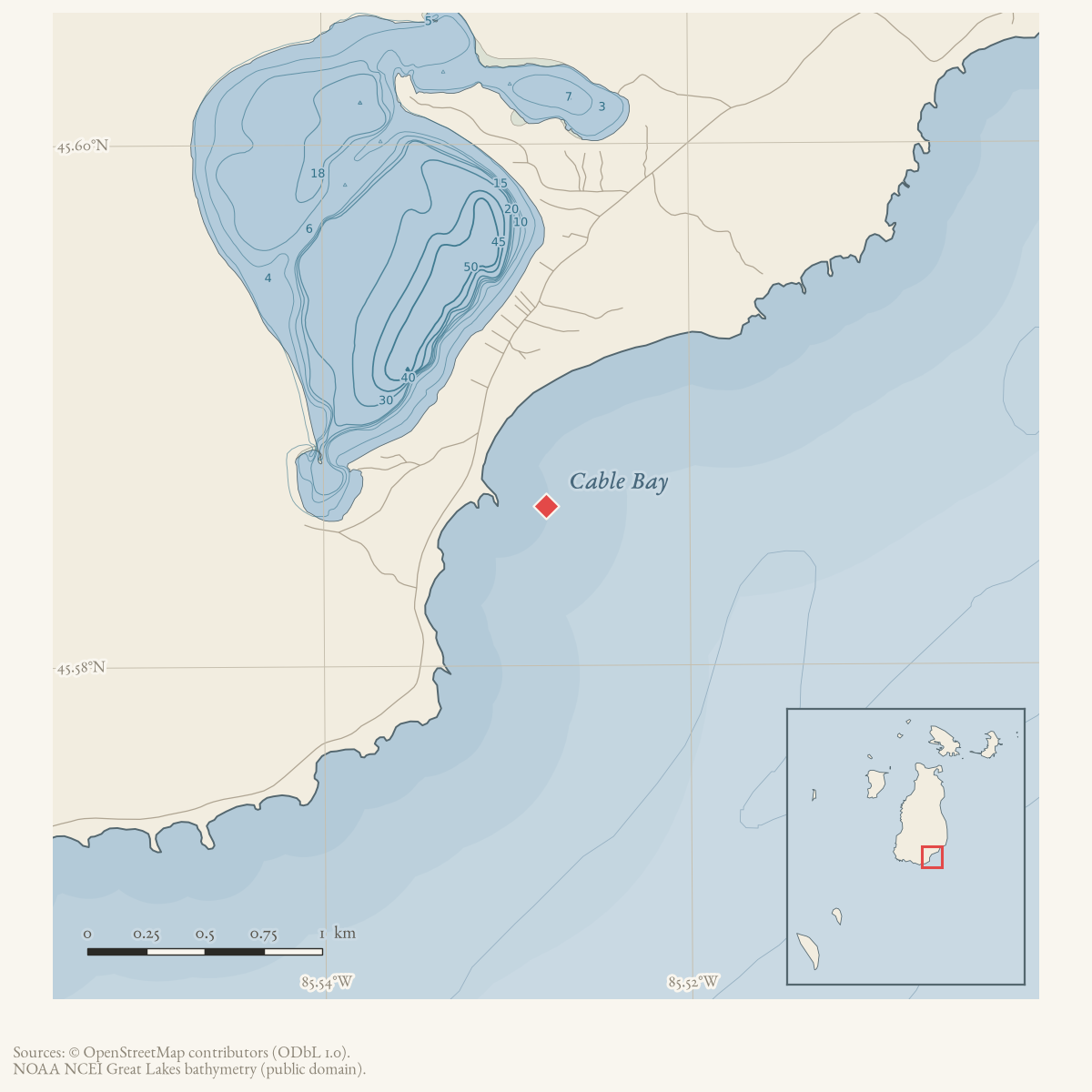
Cable Bay is a named bay near Beaver Island’s south end, GNIS feature 622418 at 45.586114° N, 85.527857° W, about 0.32 km east of Lake Geneserath.12 GNIS’s own T121 history note says the bay was named for John Cable, who kept a dock and store nearby in the 1840s and 1850s;2 a separately held October 1965 newspaper retrospective instead credits a lumber camp operated by “James Cable,” and a person article for a James F. Cable documented by an 1869 federal land patent notes the same open discrepancy without resolving it.34 The bay and the adjoining creek that bears the same family name were, independently of that dispute, an early Irish settlement site — an 1847-48 famine-emigration letter, later Beacon retrospectives, and two Northern Michigan University archaeological field seasons (around 2000 and again in 2016) all place documented nineteenth-century activity there.567 In the twentieth and twenty-first centuries the bay became a settled cottage shoreline, then the site of a sustained, still-unresolved fight against invasive phragmites reed.89
Geography
Cable Bay sits near Beaver Island’s south end. GNIS’s own T121 prose description places it “off the SW coast of Beaver Island,” but the Michigan Natural Features Inventory’s 2017 dune survey instead describes the same occurrence as running “along the southeastern shore of Beaver Island,” and the bay’s own coordinates sit east and south of the island’s overall centroid — consistent with the MNFI wording, not the GNIS prose.210 This article does not resolve the contradiction; it is recorded here as an open disagreement between two held sources describing the same feature, and the numeric coordinates, not either prose description, are treated as authoritative for geometry. Cable’s Creek flows from the east side of Lake Geneserath to Cable Bay, and a present-day real-estate listing places a bay-front property along Pat’s Road, which runs along the property’s east side — a present-day road-to-bay setting, not a surveyed boundary or a guaranteed public access right.11
Names
Two sourced accounts disagree on which Cable the bay is named for. GNIS’s
T121 history field, compiled from Board on Geographic Names files, credits
“John Cable,” who owned a dock and store near the bay in the 1840s and
1850s.2 An October 1965 Beaver Beacon installment of Hugh Harley’s
“Traveller” series, reprinted from the Donegal Democrat, instead says
Irish arrivals of the 1850s “got jobs in a lumber camp being operated by
James Cable after who the present Cable’s Bay on the main island is
named.”3 A James F. Cable is
independently documented by a 25 November 1869 federal homestead patent for
land in Township 37 North, Range 10 West — in the island’s southern
townships, consistent with, though not proof of, a connection to this area —
and a 1911 biographical sketch of his son describes James F. Cable’s work as
trading and wood-supply, a description compatible with running a lumber
camp.4 Neither account names its own source, and this article
does not choose between John and James Cable; name_origin and confidence: probable reflect that unresolved state.
GNIS records “Gable Bay” as the sole variant name for feature 622418, a
plain misreading or mishearing of “Cable,” and it is kept in alt_names as
a spelling variant of the current name, not a former name.12 No
source read for this article ties the bay’s name to the 1971 submarine power cable — and the name could not derive from that cable in any case, since
property notices already used “Cables Bay” in 1958, thirteen years before
the submarine cable was installed, and the GNIS history note and the 1965
newspaper account both place the naming in the 1840s-50s.13 The
coincidence of the name and the later cable installation is exactly that: a
coincidence, not an etymology.
Early settlement and archaeology
Beyond the disputed Cable attribution, Cable Bay recurs across more than a century and a half as a settlement and excavation site distinct from the naming question. A family letter published in the Beacon in March 1972, and reprinted in September 1991, recounts the 1847-48 famine emigration of Conal McCauley and Mary Gallagher from Arranmore, County Donegal; a relative already on the island wrote home that Beaver Island had “a lumber mill at Cable’s Bay and lots of fishing,” prompting several more Arranmore families to charter a vessel and join them.5 This independently corroborates, without proving, the 1965 essay’s claim of a Cable’s Bay lumber operation in the same period. A January 1982 Beacon historical retrospective states, without citing its own source, that “the first traces of civilization were found at Cable’s Bay and on St. James Harbor” and dates the earliest island land purchases to 1848.14 A first-person letter published in September 1963 records a settler arriving by steamer in April 1917 and exchanging land for “two lots on the shore on Cables Bay.”15
Twenty-first-century archaeology reopened the site’s early record. Northern Michigan University’s field school, directed by Dr. Scott Demel, excavated at Cable Bay in a season a 2010 Beacon retrospective places “a decade earlier” — roughly 2000 — recovering iron straight pins, percussion caps, glass beads, chinking, melted lead, a broken pen knife, pearlware and other ceramics, and unidentified iron implement parts, described as evidence of the area’s trading history.6 The same field school returned to “the early historic fishing village of Cable Bay” for a concluding season reported in July 2016, when the team “discovered prehistoric pottery for the first time” there — the first pre-contact material documented at the site.7 The same 2016 season also worked French Bay and a third season behind the Mormon Print Shop; those finds belong to their own articles and are not restated here.7
Twentieth-century settlement, recreation, and invasive species
Cable Bay became a documented recreational shoreline from the late 1950s. The earliest dated property notice found here records Warren L. Behrens of Detroit purchasing a lot at Cables Bay in December 1958 — already thirteen years before the unrelated 1971 submarine cable installation.13 Further lot purchases followed in November 1960,16 and cottage rental and sale classifieds ran in the Beacon through the 1970s, 1980s, and 1990s; a July 1973 notice advertised two seasonal cottages, and a March 1963 report recorded a Cable’s Bay fishing trip that brought up large perch.1718 Township records document routine shoreline administration: a Cable Bay Bridge rebuild was reported in October 1996 under a Trails Report heading,19 the crossing that carries Cable’s Creek Trail onto the beach, walked and confirmed in August 2026, an unspecified “Cable Bay project” carried a completion date of 31 May 1997,20 a gazebo distance variance was denied by the Zoning Board of Appeals in February 1996,21 a sludge report reached a March 1993 township meeting,22 and township caretaking of “Iron Ore and Cable Bays, and Geneserath and Fox Lakes” is recorded in August 1994.23
From the mid-2000s, Cable Bay became the island’s most visible front in a sustained fight against invasive phragmites reed. An October 2006 report found the bay’s infestation had grown to cover a third of its shoreline at heights over ten feet, warning the bay “could be lost in two years or so.”8 By June 2007 the Cable’s Bay patch, at about 1.5 acres, was described as the island’s single largest phragmites stand within a total infestation of 8-10 acres.24 Volunteer removal continued for years: a November 2010 report on a 46-volunteer eradication effort found phragmites reduced island-wide except at Cable’s Bay, where it had proliferated.9 No source held here records the infestation’s final outcome.
Ecological profile
MNFI Report 2017-11 records a 30-acre open-dune occurrence at Cable Bay (EO 530, rank C, G3/S3; p. 106), consisting of low parabolic dunes and a low foredune along Beaver Island’s southeastern shore. Its fine-textured, wind-blown and wave-worked sands are alkaline around pH 8.0. Marram grass and sand reed grass dominate the ground cover; wormwood, white camas, Pitcher’s thistle, Lake Huron tansy, beach pea, plains puccoon, harebell, wheat grass, June grass, horsetail, Gillman’s goldenrod, and common milkweed are also recorded.
Common juniper, creeping juniper, soapberry, and bearberry form a 20–50 percent low-shrub layer. Scattered trees include balsam poplar, northern white-cedar, paper birch, trembling aspen, sandbar willow, choke cherry, white pine, red pine, and balsam fir, with canopy cover only 1–10 percent. Deer trails and browse occur throughout. The state- and federally threatened Pitcher’s thistle and state-special-concern Lake Huron tansy are important plant records, not evidence of current occupancy beyond the survey.
MNFI identifies residential development, foot-traffic erosion, and devegetation as the primary threats. Spotted knapweed, Canada bluegrass, and bladder campion are locally common invasive plants. The recommendation is to limit human traffic with signs about fragile dunes. This occurrence description is not a current legal boundary, property determination, complete plant or wildlife inventory, or present-condition assessment.
Significance
Cable Bay’s record runs from a disputed 1840s-50s naming, through documented 1847-48 Irish famine settlement and two archaeological seasons twenty centuries apart in evidence if not in years, to a late-twentieth-century cottage shoreline and a still-open twenty-first-century fight against an invasive reed threatening to erase the same shoreline the settlers first worked. Unlike French Bay’s isolation, Cable Bay’s record is one of continuous, increasingly dense occupation — property notices in nearly every decade from 1958 onward — which is also what has made it the site both archaeology and invasive-species management keep returning to.
Open questions
- Can the John/James Cable discrepancy be resolved through land records, contemporary newspapers, or the Journal of Beaver Island History? The 1869 federal patent to James F. Cable is a separately recorded land issuance, but it does not by itself resolve the name origin.
- Where were Cable’s dock, store, and the lumber camp described in the 1965 retrospective?
- Which historical and modern maps define the relationship between Cable Bay, the Cable Bay plat, and Lake Geneserath?
- Does GNIS’s own “SW coast” T121 description reflect an error, an older reference frame, or a different anchor point than the MNFI survey’s “southeastern shore”? Neither this article nor its held sources resolve it.
- What were the results and formal findings of the two Cable Bay archaeological seasons (circa 2000 and 2016)? No excavation report or artifact catalog beyond the two newspaper accounts is held here.
- What was the scope of the 1997 “Cable Bay project,” and what became of the Cable Bay Bridge rebuild reported in 1996?
- Did the phragmites infestation reported through 2010 reach the “lost in two years” outcome warned of in 2006, or was it brought under control? No source held here reports a later outcome.
If you can answer any of these, or correct anything above, the archive wants to hear it — see Corrections.
See also
Footnotes
-
U.S. Geological Survey, Geographic Names Information System, Domestic Names (Michigan), retrieved 2026-07-28 (
data/federal/gnis/gnis_names.geojson), feature 622418. ↩ -
USGS GNIS, Feature Descriptions (T121), retrieved 2026-07-28 (
data/federal/gnis/gnis_feature_descriptions.csv), feature 622418. ↩ ↩2 ↩3 ↩4 -
Beaver Beacon, October 1965, “An O’Donnell’s Discovery” (Hugh Harley, “The Traveller,” reprinted from the Donegal Democrat). ↩ ↩2
-
Person article person/james-f-cable; United States General Land Office homestead patent to James F. Cable, November 1, 1869; Alvah L. Sawyer, A History of the Northern Peninsula of Michigan and Its People, vol. III (1911), “Claud C. Cable,” p. 1363. ↩ ↩2
-
Beaver Beacon, March 1972, “Beaver Tales” (McCauley family letter); reprinted September 1991. ↩ ↩2
-
Charlevoix Courier, July 18, 2016, “Beaver Island dig turns up intriguing discoveries.” ↩ ↩2 ↩3
-
Beaver Beacon, November 2010, phragmites eradication report. ↩ ↩2
-
Joshua G. Cohen, Natural Community Surveys of Beaver Island Archipelago (MNFI Report 2017-11, 2017), “30. Cable Bay,” p. 106. ↩
-
LakeHomes.com, “26690 Pat’s Road, Beaver Island,” retrieved 2026-08-02. ↩
-
USGS GNIS, All Names (national) (
data/federal/gnis/gnis_variant_names.csv); “Gable Bay” is the sole variant recorded for feature 622418. ↩ -
Beaver Beacon, December 1958, “New Island Property Owners.” ↩ ↩2
-
Beaver Beacon, January 1982, “Beaver Island History.” ↩
-
Beaver Beacon, September 1963, letter from a settler’s descendant. ↩
-
Beaver Beacon, November 1960, “New Property Owners.” ↩
-
Beaver Beacon, July 1973, classified notice. ↩
-
Beaver Beacon, March 1963, local fishing report. ↩
-
Beaver Beacon, October 1996, “Trails Report.” ↩
-
Beaver Beacon, February 1997, Peaine Township minutes. ↩
-
Beaver Beacon, February 1996, Zoning Board of Appeals report. ↩
-
Beaver Beacon, March 1993, Peaine Township minutes. ↩
-
Beaver Beacon, August 1994, township minutes correction. ↩
-
Beaver Beacon, June 2007, phragmites program update. ↩
Maps for this place
These Atlas plates provide regional context. They do not establish a precise boundary, current ownership, access right, operating status, or field condition.
- EnvironmentSoils, wetlands, hydrography, and terrain
- GeologyGeneralized geology and landforms
- HydrologyMapped water and wetland context
- AccessMapped routes, facilities, and protected areas
- Land surveyPLSS geometry and historic GLO patent-location context
The dated record
Sources
- GNIS feature 622418; feature class 'Bay'.federal · gnis · gnis_names
- Feature 622418 description says John Cable owned a dock and store near the bay during the 1840s and 1850s.federal · gnis · gnis_feature_descriptions
- Variant names: Gable Bay.federal · gnis · gnis_variant_names
- Feature 622418 description says John Cable owned a dock and store near the bay during the 1840s and 1850s.federal · gnis · gnis_feature_descriptions
- Retrospective account says Irish arrivals found work in a lumber camp operated by James Cable and identifies present Cable’s Bay as named for him; this conflicts in the forename with the GNIS/T121 John Cable note.data1 · beaver-island-archive · beaver_beacon · 1965-10_Beaver-Beacon
- The held seven-page issue scan is paired with the OCR source and confirms the published notice or report; it does not expand the source-specific identity, event, or outcome claims.data1 · beaver-island-archive · scans · beaver_beacon · issues · 1965-10_Beaver-Beacon
- Reports a Cable’s Bay fishing trip that brought up large perch.data1 · beaver-island-archive · beaver_beacon · 1963-03_Beaver-Beacon
- The held six-page issue scan is paired with the OCR source and confirms the published notice or report; it does not expand the source-specific identity, event, or outcome claims.data1 · beaver-island-archive · scans · beaver_beacon · issues · 1963-03_Beaver-Beacon
- Advertises two seasonal cottages for rent on Cable Bay, documenting twentieth-century recreational use without locating the cottages precisely.data1 · beaver-island-archive · beaver_beacon · 1973-07_Beaver-Beacon
- The held eleven-page issue scan is paired with the OCR source and confirms the classified notice; it does not locate the cottages precisely or establish a surveyed bay boundary.data1 · beaver-island-archive · scans · beaver_beacon · issues · 1973-07_Beaver-Beacon
- Reports A. C. Comer and Edward Ryder households purchasing lots in Cables Bay; it does not provide deeds, parcel identifiers, prices, or complete purchaser identities.data1 · beaver-island-archive · beaver_beacon · 1960-11_Beaver-Beacon
- The held three-page issue scan is paired with the OCR source and confirms the published notice or report; it does not expand the source-specific identity, event, or outcome claims.data1 · beaver-island-archive · scans · beaver_beacon · issues · 1960-11_Beaver-Beacon
- Current or historical listing places a property on Cable Bay at a Pat's Road address and says Pat's Road runs along the east side of the property. It is a real-estate listing, not a bay boundary, title, access-right, or complete shoreline record.
- Project-generated MNFI 2017 soil, vegetation, and wildlife crosswalk, preserving MNFI Report 2017-11, Cable Bay open dunes occurrence (EO 530), report p. 106.Described in this archive: MNFI soil, vegetation, tree, and wildlife crosswalk, 2017.The 30-acre record is a source-defined open-dune occurrence along Cable Bay; it is not a current legal boundary, ownership determination, or complete survey of the bay or island. No public copy of this file is known; the archive holds one and can provide it on request.research · island_farming · crosswalks · mnfi_soil_vegetation_wildlife_crosswalk
- Visual page evidence held with provenance sidecar; the image anchors the occurrence description and does not establish modern geometry or current condition.research · island_farming · evidence · mnfi-report-2017-11-page-0106-cable-bay-open-dunes
- Read directly (PDF text extraction). States the open-dune occurrence "occurs along the southeastern shore of Beaver Island" -- this direct survey wording is the basis for describing the bay as southeastern rather than southwestern; see the Geography section for the conflict with GNIS's own T121 prose description.research · island_farming · sources · mnfi_natural_community_surveys_beaver_archipelago_2017_11
- Feature 622418 description reads in full: "Located off the SW coast of Beaver Island, 0.32 km (0.2 mi) E of Lake Geneserath and 17.7 km (11 mi) S of Saint James." This "SW coast" wording conflicts with the MNFI survey's "southeastern shore" and with the feature's own coordinates, which sit southeast of the island's centroid; the discrepancy is not resolved here.federal · gnis · gnis_feature_descriptions
- Reports Warren L. Behrens of Detroit purchasing a lot at Cables Bay -- the earliest dated property-purchase notice found here, predating the 1971 submarine power cable by thirteen years. The holding institution's portal restricts automated access; the archive holds a copy of this issue and can provide it on request.data1 · beaver-island-archive · beaver_beacon · 1958-12_Beaver-Beacon
- First-person account of arriving on Beaver Island in April 1917 aboard the steamer Columbia and exchanging land for "two lots on the shore on Cables Bay," met at Nomad by George Carter of the Citizen's Realty Company.data1 · beaver-island-archive · beaver_beacon · 1963-09_Beaver-Beacon
- A descendant's letter recounts grandparents Conal McCauley and Mary Gallagher emigrating from Arranmore, County Donegal, after the 1847-48 potato famine; a relative wrote home that Beaver Island had "a lumber mill at Cable's Bay and lots of fishing," prompting several more families to charter a vessel and join them. Independently corroborates, without proving, the 1965 essay's James Cable lumber-camp account.data1 · beaver-island-archive · beaver_beacon · 1972-03_Beaver-Beacon
- A near-identical reprint of the March 1972 McCauley family letter; both are treated as one account, not independent corroboration of each other. The holding institution's portal restricts automated access; the archive holds a copy of this issue and can provide it on request.data1 · beaver-island-archive · beaver_beacon · 1991-09_Beaver-Beacon
- A local-history retrospective (attributed in context to Mark LaFreniere) states that "the first traces of civilization were found at Cable's Bay and on St. James Harbor," identifies the early settlers as mostly Irish fishermen, and dates the first Beaver Island land purchases to 1848. A secondary, undocumented retrospective account, not treated as an independently verified primary claim. The holding institution's portal restricts automated access; the archive holds a copy of this issue and can provide it on request.data1 · beaver-island-archive · beaver_beacon · 1982-01_Beaver-Beacon
- Beaver Beacon, July 2010, "Digging Up the Past."Reports a Northern Michigan University archaeology field season directed by Dr. Scott Demel excavating the Burke Farm, Greenes' Bay, and a beach cabin south of Cable's Creek in June 2010, and recalls that "the Cable's Bay site was a decade earlier" -- placing an earlier, undated Cable Bay excavation at roughly 2000 -- recovering iron straight pins, percussion caps, glass beads, chinking, melted lead, a broken pen knife, pearlware and other ceramics, and unidentified iron implement parts, described as evidence of the area's trading history. No public copy of this file is known; the archive holds one and can provide it on request.data1 · beaver-island-archive · beaver_beacon · 2010-07_Beaver-Beacon
- Charlevoix Courier, July 18, 2016, "Beaver Island dig turns up intriguing discoveries."Reports Northern Michigan University's Dr. Scott Demel and 17 students "wrapped up an investigation of the early historic fishing village of Cable Bay, where they discovered prehistoric pottery for the first time" -- the concluding season of the multi-year Cable Bay investigation that began around 2000. The same field season also worked at French Bay and behind the Mormon Print Shop; those finds are recorded in their own articles, not here. No public copy of this file is known; the archive holds one and can provide it on request.data1 · beaver-island-archive · charlevoix · Charlevoix-Courier-2016
- Beaver Beacon, October 2006, "Phragmites Report."Reports invasive phragmites reed spreading at several island shorelines, with the growth at Cable's Bay "now stretches along a third of the shoreline with heights over 10 feet," and warns the bay "could be lost in two years or so." No public copy of this file is known; the archive holds one and can provide it on request.data1 · beaver-island-archive · beaver_beacon · 2006-10_Beaver-Beacon
- Beaver Beacon, June 2007, phragmites program update.Reports the largest island phragmites patch, at Cable's Bay, at about 1.5 acres, within a total island infestation of 8-10 acres, with spraying-permit costs under $1,000 per acre. No public copy of this file is known; the archive holds one and can provide it on request.data1 · beaver-island-archive · beaver_beacon · 2007-06_Beaver-Beacon
- Beaver Beacon, November 2010, phragmites eradication report.Reports 46 volunteers spending roughly ten hours removing phragmites island-wide, with fewer plants found than the previous year except at Cable's Bay, where the reed had proliferated. No public copy of this file is known; the archive holds one and can provide it on request.data1 · beaver-island-archive · beaver_beacon · 2010-11_Beaver-Beacon
- Reports a distance variance from Lake Michigan for a gazebo at Cable's Bay denied by the Zoning Board of Appeals. The holding institution's portal restricts automated access; the archive holds a copy of this issue and can provide it on request.data1 · beaver-island-archive · beaver_beacon · 1996-02_Beaver-Beacon
- Reports the Cable Bay Bridge scheduled to be rebuilt, alongside outhouse work at Lake Geneserath and Bill Wagner Campground. The holding institution's portal restricts automated access; the archive holds a copy of this issue and can provide it on request.data1 · beaver-island-archive · beaver_beacon · 1996-10_Beaver-Beacon
- Records a "CABLE BAY project" with a completion date of May 31, 1997; the minutes give no further description of the project's scope. The holding institution's portal restricts automated access; the archive holds a copy of this issue and can provide it on request.data1 · beaver-island-archive · beaver_beacon · 1997-02_Beaver-Beacon
- Records a report from a deputy on sludge at Cable's Bay attached to the township meeting minutes; no further detail on source or resolution is given. The holding institution's portal restricts automated access; the archive holds a copy of this issue and can provide it on request.data1 · beaver-island-archive · beaver_beacon · 1993-03_Beaver-Beacon
- Records that Glen LaFreniere cared for Iron Ore and Cable Bays and Geneserath and Fox Lakes, evidence of routine township shoreline maintenance responsibility. The holding institution's portal restricts automated access; the archive holds a copy of this issue and can provide it on request.data1 · beaver-island-archive · beaver_beacon · 1994-08_Beaver-Beacon
Added 28 July 2026 · revised 4 August 2026. Recent changes
Cite this article
Beaver Island Archive, “Cable Bay”, https://beaverislandarchive.org/places/cable-bay/, accessed [date], citing U.S. Geological Survey, Geographic Names Information System, Domestic Names (Michigan), retrieved 2026-07-28. (and 29 further sources listed on the page).
Last revised 2026-08-04. Fill in [date] with the date you read it — this page is static and cannot know that.