

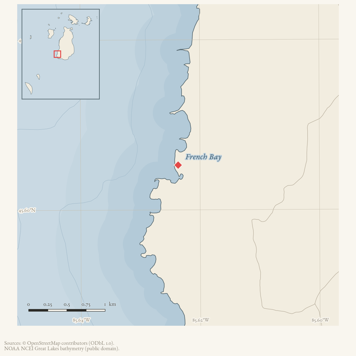
- Coordinates
- 45.6053° N, 85.6237° WGoogle Maps: French BayDownload KML
- Concepts
- environmentgeologysoilsforeststreesvegetationplantswildlifeanimalsconservationstewardshipmaritimeshipwreckslumberingtourismfishinghuntingfireland-userecreation
- Within
- Beaver Island
- Media
- Beaver Island History Map, 1978 revision · Plat of Big Beaver Island, 1901 · Plat of the south end of Beaver Island, 1930s
Summary
French Bay is a bay on Beaver Island’s southwest shore, GNIS feature 626476 at 45.605281° N, 85.623692° W.1 A 1966 local history essay names it, alongside St. James, Green Bay, and Cable’s Bay, among the harbors that sheltered early sailing and steamship traffic around the island.2 The earliest dated record found here of the bay by name is an 1903 newspaper note on a hydrographic survey of its entrance;3 the earliest account of activity there is a fishing camp used by the Boyle family from 1884.4 Over the following century French Bay recurs as a site of marine loss and body recovery, seasonal fishing and logging, deer hunting, a 1989 forest fire, a long-running road-access dispute tied to endangered plant species, and — from 2000 onward — a fixture of Central Michigan University’s nature-education program and a recreation-planning priority for island landowners.5
Geography
French Bay sits on Beaver Island’s southwest side, an isolated stretch of shoreline reached historically by a rough foot trail rather than a maintained road.67 That footpath has its own article: French Bay Trail. Nineteenth- and twentieth-century sources place it between Miller’s Marsh and Cheyenne Point along the west shore road corridor, with Iron Ore Bay the next named harbor to the south.85 Dr. and Mrs. Sorenson’s 1953-61 circuit of the island’s entire shoreline found the stretch from French Bay to Iron Ore Bay the single most difficult section of the walk, and the Sand Bay area, on the island’s opposite side, the easiest.9
Names
No source read for this article explains why the bay is called “French.” The island’s French-colonial period (Charlevoix’s 1721 passage, the Isles-du-Castor toponymy, the eighteenth-century fur trade) is well documented in Beaver Island’s own history, and a French etymology for the name is plausible on its face — but plausibility is not a citation, and none of the sources gathered here, including a 2016 newspaper account of an island-wide oral tradition about a French soldiers’ fort, ties that history to this specific bay’s name.6 This is recorded as an open question rather than filled with an inference.
The 1978 History Map itself labels seventeenth-century French-voyageur use of the bay as only “alleged.” No source found in this review promotes that tradition beyond allegation. The map also places the 1887 Frank C. Leighton stranding nearby and adds twenty rescuers and 100 tons of ore thrown overboard. A 1961 local retrospective supports only the broader west-side stranding, iron-ore cargo, and rescue. The federal 1887–88 casualty table was searched and does not list the vessel; surviving Beaver Island Life-Saving Station logs for 1883–1941 remain the best primary-source lead.
GNIS carries a single record for the feature, with no variant-name row,10
so alt_names and former_names are both left empty: there is no
evidenced spelling variant to record as the former and no superseded name to
record as the latter. One incidental possessive form, “French’s Bay,”
appears in a single 1988 Beacon report on a road dispute;7 it is
not attested in GNIS and is treated here as an incidental spelling in one
source, not a name to record in frontmatter.
Fishing camps, marine losses, and unresolved finds, 1884-1964
The earliest documented use of French Bay is as a seasonal fishing camp. Danish-born ship captain “Jensen,” recalled in his own 1939 obituary, arrived on Beaver Island by boat in June 1884 and met Daniel Boyle and his sons Hugh and Dennis fishing at Squaw Island; the Boyles, about to leave for their own fishing camp “at French Bay, at the south end of Beaver Island,” lent Jensen the use of their shanty for the rest of the season, beginning a friendship the obituary says was never broken.4 A Beaver Beacon photo caption from May 2006 identifies collapsed logs at the bay as “the old Dan Boyle cabin (1886) at French Bay” — a date consistent with, though not explicitly tied in either source to, the Boyle family’s 1884 camp.11
The bay’s entrance was significant enough to navigation that the steamboat Larian was sent in May 1903 to survey water velocity there and at the Rock Island passage, the earliest dated attestation found here of French Bay as a named point of nautical interest.3 It also served, more than once, as a place where the lake gave up its dead. When the gasoline boat Vega burned near Martin Point on Sand Bay on 15 June 1914, killing Jerry Yettaw, William Heath, and Henry Papineau — a loss treated in full in its own article — Yettaw’s body, kept afloat by a life preserver, drifted roughly three-quarters of a mile and washed ashore at French Bay, where a party out horseback riding found it on 21 June.12 The fishing boat Lucille II went aground on the beach at French Bay in heavy fog on the morning of Thursday, 30 May 1929; no source held here records the vessel’s fate afterward.13 And when the salvage boat Marold II exploded at Simmons Reef on 1 January 1937 while pumping gasoline from the stranded tanker J. Oswald Boyd — the subject of its own article, Explosion and Loss of the Marold II — killing five Beaver Island men, the body of Capt. L. L. Hill, one of three whom the Coast Guard had by 8 January given up searching for as lost at sea, was found in French Bay by Lawrence and Robert McDonough, brothers of a fourth victim, Bruce McDonough. The report is dated Wednesday 19 May 1937 and says only that the body was recovered “last Friday,” which would be 14 May; the source does not print the date. Hill’s remains were taken to Detroit for cremation, the ashes bound for burial at his former home in Kenosha, Wisconsin.14 That recovery is not recorded in the article on the explosion itself.
Two later, unresolved finds are recorded at French Bay without a documented source or identity, each the subject of its own article in this knowledge base. In the summer of 1963, Al Dobler of Detroit found underwater wrecks at French Bay, Iron Ore Bay, and Sand Bay; the Beacon gives no vessel name, position, or further investigation.15 In November 1964, hunters Glenn Ingalls and Robert Somerville found the upper half of a human skull about a mile north of French Bay; the county sheriff, coroner, and state police could not determine its age or identity, and the Beacon raised, without resolving, the possibility that it belonged to a crewman of the Carl D. Bradley, lost six years earlier.16 Neither find is treated here as evidence for the other, or tied to any of the identified marine losses above.
Forestry, hunting, and a contested road, 1958-1996
Twentieth-century land use around French Bay ran through logging, hunting, and a running dispute over the bay’s own access road. State Forester Jack Lockwood reported in September 1967 that saddled prominent caterpillars had virtually stripped an 1,100-acre hardwood stand about a mile inland from French Bay, one of two large defoliated tracts on the island that year.17 A 1974 Game Club report discussed a proposed timber harvest on state land between Miller’s Marsh and French Bay, intended to open browse for game.8 Hunters used the area regularly: a November 1971 diary of a week’s deer season records hunting “out back” of French Bay and nearby Green’s Bay day after day.18 A 1961 notice records that McClure Oil Company’s drilling equipment was moved to a new site “across from French Bay road” after an unsuccessful well near Miller’s Marsh reached granite at 4,800 feet.19
On 13 July 1989 a forest fire at French Bay, spotted from the air by pilot Paul Welke, burned only a few acres but intensely; the Beaver Island Volunteer Fire Department, guided to the site by radio and reaching it only after Bob Graves and Buddy Martin cut an equipment road through with earth movers, worked from mid-afternoon until 11 p.m. and returned over the following two days for flare-ups.20 The Department was still unreimbursed by the DNR — which the Beacon noted owns almost half of Peaine and St. James Townships but pays no property tax — as of March 1992.21 A separate, longer-running dispute concerned the road to the bay itself: in November 1988 a property owner asked the Road Commission to regrade the route, but work stopped once endangered plant species were found along it, and many residents preferred the access remain a foot path, as it had been for years.7 The same period saw the DNR and the Charlevoix County Road Commission meeting with the Beaver Island Property Owners Association (BIPOA) to work out a route that would avoid sensitive areas — recalled in the Beacon’s “Twenty Years Ago” column two decades later, which places the meeting around 1989.22 A 1996 township meeting discussed a state coastal-zone-management grant to develop French Bay for camper access.23
Conservation study and nature education, 2000-2016
From July 2000, the Central Michigan University Biological Station ran a recurring “Flora of French Bay” nature walk, led by Dr. Dan Wujek, as part of its public summer field-trip series; the walk recurred at least in 2006 and 2008, each time noting the site’s remoteness and the effort of the hike down and up the bluff to reach it.24 In May 2002 biologist Jim Gillingham named French Bay, alongside the Egg Lake bog and Iron Ore Creek, as one of three specific locations on the island needing conservation attention.25
Between 2002 and 2004, the Beaver Island Property Owners Association sponsored, and Central Michigan University Biological Station faculty supported, a systematic survey of the island’s public shoreline tracts, the Beaver Island Recreation Resource Project, coordinated by Dr. John R. (Jack) Kelly and funded by the Great Lakes Aquatic Network and Fund. It evaluated French Bay as “Tract 6,” split into Tract A — several small, isolated bays recommended for long-term protection — and Tract B, described as having “a long history of hiking, picnicking, and camping,” its beach “down a steep hill off an old unimproved road, blocked by beaver ponds” — the ponds block the road, not the footpath — and holding an abundance of dwarf lake iris; the final report’s short list of priorities named “French Bay: Develop an access and site plan for this special south end site.”5 BIPOA separately asked Peaine Township in September 1997 to lobby the state to establish a park at French Bay; the Beacon recalled the same request in its “Ten Years Ago” column a decade later, in October 2007.26
In 2016, a Northern Michigan University archaeological field school directed by Scott Demel investigated the remains of three log cabins at French Bay first located by a 2012 compass-and-GPS survey. Recovered ceramic sherds, a clay pipe stem, buttons, and glass bottles, together with cut logs bearing roughly six inches of moss growth, led Demel to a working assessment — not a laboratory date — of a logging camp roughly a century old.6 The same field season worked an early historic fishing village at Cable Bay and completed a third season behind the Mormon Print Shop; French Bay’s cabins are recorded here only as their own find, not folded into either of those separate sites.6
Ecological profile
MNFI Report 2017-11 records a French Bay boreal forest occurrence (EO 6311, 197 acres, report pp. 19–20) along Beaver Island’s southwestern shoreline. The survey describes a fine-grained transition among limestone cobble shore, sand and gravel beach, open dunes, Great Lakes marsh, and several inland forest and swamp communities. Because hydrology and soils change over short distances, the report cautions that the boreal forest is difficult to map precisely; this is ecological context for the named bay, not a claim that the GNIS bay geometry is the occurrence boundary.
The recorded soils have a shallow 5–10 cm acidic A horizon (pH 4.5–5.0) over acidic medium-textured sands (pH 5.0–6.0), locally with about 50 cm of sand over cobble. Rolling ground reflects former sand and cobble shoreline settings. The canopy shifts with that substrate: pines are more prevalent on former sand shoreline features, while northern white-cedar is dominant over former limestone cobble shore.
The MNFI occurrence is not a current legal boundary, ownership determination, or complete survey of French Bay.
The stand is uneven-aged and shaped by frequent windthrow, with coarse woody debris, blowdown gaps, and canopy closure ranging from roughly 50 to 90 percent. MNFI cored a red pine 50.2 cm in diameter at more than 140 years and northern white-cedars 31.5 cm and 51.5 cm in diameter at more than 100 and 120 years, respectively. Northern white-cedar dominates the canopy with white spruce, paper birch, trembling aspen, red maple, white pine, red pine, and red oak. The understory and ground layer include balsam fir, beaked hazelnut, Canada blueberry, twinflower, Canada mayflower, bunchberry, stiff clubmoss, and many other boreal associates. Dwarf lake iris (Iris lacustris), identified by the survey as state- and federally threatened and discussed further in Native and rare plants, is locally dominant in parts of the recorded community — a finding independently corroborated by the 2004 Recreation Resource Project’s description of Tract B’s abundant dwarf lake iris.5
Deer trails and browse occur throughout, and MNFI considers the forest likely to serve as a winter deer yard. The absence of yew, abundant on nearby High Island, is interpreted as a possible deer-browse effect on species composition and structure. Past logging is represented by cut stumps near the shoreline and two-tracks; windthrow remains an important natural disturbance. The report recommends allowing natural processes to continue, retaining an intact buffer, monitoring deer impacts, and using deer exclosures to support conifer regeneration. These recommendations are tied to the 2017 occurrence and are not evidence that a treatment, cull, or exclosure was later completed.
Significance
French Bay’s significance is cumulative rather than singular: no one event made it prominent, but the same isolated stretch of shoreline recurs across a century and a half as a fishing camp, a place bodies from three separate Lake Michigan tragedies (part of the broader record in Shipwrecks and marine casualties) came ashore, a logging site, a hunting ground, a contested road, a recurring field-trip destination, and — as of the 2004 Recreation Resource Project — a named priority for public access planning. Its ecological standing, documented independently by MNFI’s 2017 boreal forest survey, gives the same isolation a present-day conservation rationale distinct from, but consistent with, the difficulty of access that runs through the historical record.
Open questions
- Why is the bay named “French”? No source read for this article — including a 2016 account of an island-wide French-soldiers legend — ties a specific etymology to this bay.
- Which wrecks, if any, can be identified from the 1963 diving report and authoritative chart or archaeological records? Does either the 1929 Lucille II grounding or an unnamed 1963 find correspond to remains still present at the site?
- What became of the Lucille II after going aground in 1929: refloated, salvaged, or abandoned?
- Is the “old Dan Boyle cabin (1886)” identified in a 2006 photo caption the same fishing camp the 1939 Jensen obituary places at French Bay in 1884, or a distinct, later structure?
- Do the three log cabins found by the 2012 NMU survey correspond to the Boyle-era fishing camp, a later independent logging camp, or both? A laboratory dating of the recovered artifacts would resolve Demel’s working “about a century old” estimate.
- Can the proposed 1974 timber work and the 1967 defoliated hardwood stand be tied to state forestry records without treating a proposal as completed harvesting?
- Was a formal access route or state park at French Bay ever completed following the 1989 route discussion and the 1997 park request, or does the 1988 preference for a foot-path-only access still hold?
If you can answer any of these, or correct anything above, the archive wants to hear it — see Corrections.
See also
- Iron Ore Bay
- Greene’s Bay
- Miller’s Marsh
- Wreck of the Vega
- Explosion and Loss of the Marold II
- The Sorensons and Tom Chmura complete separate walks around Beaver Island, 1961
- Skin-diving and historic-wreck exploration around Beaver Island, 1963
- Human skull fragment found north of French Bay, 1964
- Native and rare plants
- Shipwrecks and marine casualties
Footnotes
-
U.S. Geological Survey, Geographic Names Information System, Domestic Names (Michigan), retrieved 2026-07-28 (
data/federal/gnis/gnis_names.geojson), feature 626476. ↩ -
Beaver Beacon, February 1966, local history essay (Hugh Harley, “The Traveller,” reprinted from the Donegal Democrat). ↩
-
Charlevoix Courier, January 11, 1939, “Beaver Island Correspondence” (obituary of Capt. Jensen). ↩ ↩2
-
Beaver Beacon, August 2004, “Special Summary of the Beaver Island Recreation Resource Project.” ↩ ↩2 ↩3 ↩4
-
Charlevoix Courier, July 18, 2016, “Beaver Island dig turns up intriguing discoveries.” ↩ ↩2 ↩3 ↩4
-
Beaver Beacon, November 1988, Road Commission report. ↩ ↩2 ↩3
-
Beaver Beacon, April 1974, Game Club report. See also place/millers-marsh. ↩ ↩2
-
Beaver Beacon, September 1961, “Patience and Perseverance.” See also event/beaver-island-shore-walks-completed-1961. ↩
-
USGS GNIS, All Names (national) (
data/federal/gnis/gnis_variant_names.csv); no variant row exists for feature 626476. ↩ -
Beaver Beacon, May 2006, photo caption. ↩
-
Charlevoix Courier, July 1, 1914, “Two Bodies Are Found.” See also the event’s own article, event/vega-shipwreck-1914. ↩
-
Charlevoix Courier, June 5, 1929, correspondence column. ↩
-
Charlevoix Courier, May 19, 1937, “Recover Fourth Body of Marold Explosion.” See also event/explosion-of-marold-ii-1937 and person/l-l-hill. ↩
-
Beaver Beacon, August 1963, “Under Water Wonderland.” See also event/beaver-island-underwater-wreck-exploration-1963. ↩
-
Beaver Beacon, December 1964, “Mystery Skull.” See also event/beaver-island-mystery-skull-found-1964. ↩
-
Beaver Beacon, September 1967, “Beaver Isle Tree Defoliation Not Permanent.” ↩
-
Beaver Beacon, November 1971, hunting diary. ↩
-
Beaver Beacon, November 1961, “McClure Oil Company.” ↩
-
Beaver Beacon, July 1989, “French Bay Forrest Fire Squelched.” ↩
-
Beaver Beacon, March 1992, Road Committee and Fire Department report. ↩
-
Beaver Beacon, August 2009, “On This Date,” “Twenty Years Ago.” ↩
-
Beaver Beacon, September 1996, “Briefly … the Minutes” (Peaine Township). ↩
-
Beaver Beacon, July 2000, “The Ever-Popular CMU Nature Walks.” ↩
-
Beaver Beacon, May 2002, Beaver Island Association meeting report. ↩
-
Beaver Beacon, October 1997, “Briefly … the Minutes” (Peaine Township, meeting of September 10, 1997); recalled in Beaver Beacon, October 2007, “On This Date,” “Ten Years Ago.” ↩
Maps for this place
These Atlas plates provide regional context. They do not establish a precise boundary, current ownership, access right, operating status, or field condition.
- EnvironmentSoils, wetlands, hydrography, and terrain
- GeologyGeneralized geology and landforms
- HydrologyMapped water and wetland context
- AccessMapped routes, facilities, and protected areas
- Land surveyPLSS geometry and historic GLO patent-location context
The dated record
Sources
- GNIS feature 626476; feature class 'Bay'.federal · gnis · gnis_names
- Includes French Bay among the harbors that provided shelter for early sailing and steamship traffic around Beaver Island.data1 · beaver-island-archive · beaver_beacon · 1966-02_Beaver-Beacon
- The held seven-page issue scan is paired with the OCR source and confirms the published notice or report; it does not expand the source-specific identity, event, or outcome claims.data1 · beaver-island-archive · scans · beaver_beacon · issues · 1966-02_Beaver-Beacon
- Describes the French Bay-to-Iron Ore Bay section as the most difficult part of a shore walk around Beaver Island.data1 · beaver-island-archive · beaver_beacon · 1961-09_Beaver-Beacon
- The held seven-page issue scan is paired with the OCR source and confirms the published notice or report; it does not expand the source-specific identity, event, or outcome claims.data1 · beaver-island-archive · scans · beaver_beacon · issues · 1961-09_Beaver-Beacon
- Reports that a diver found wrecks at French Bay, Iron Ore Bay, and Sand Bay; it does not identify a vessel or precise wreck position.data1 · beaver-island-archive · beaver_beacon · 1963-08_Beaver-Beacon
- The held five-page issue scan is paired with the OCR source and confirms the published notice or report; it does not expand the source-specific identity, event, or outcome claims.data1 · beaver-island-archive · scans · beaver_beacon · issues · 1963-08_Beaver-Beacon
- Reports a skull found about a mile north of French Bay and explicitly leaves its identity unresolved; this is retained as a dated nearby observation, not a French Bay event.data1 · beaver-island-archive · beaver_beacon · 1964-12_Beaver-Beacon
- The held seven-page issue scan is paired with the OCR source and confirms the published notice or report; it does not expand the source-specific identity, event, or outcome claims.data1 · beaver-island-archive · scans · beaver_beacon · issues · 1964-12_Beaver-Beacon
- Places an 1,100-acre hardwood stand about a mile inland from French Bay and reports state forestry and conservation inspection.data1 · beaver-island-archive · beaver_beacon · 1967-09_Beaver-Beacon
- The held nine-page issue scan is paired with the OCR source and confirms the published notice or report; it does not expand the source-specific identity, event, or outcome claims.data1 · beaver-island-archive · scans · beaver_beacon · issues · 1967-09_Beaver-Beacon
- Records deer hunting at French Bay and nearby Green’s Bay during the 1971 season.data1 · beaver-island-archive · beaver_beacon · 1971-11_Beaver-Beacon
- The held ten-page issue scan is paired with the OCR source and confirms the published notice or report; it does not expand the source-specific identity, event, or outcome claims.data1 · beaver-island-archive · scans · beaver_beacon · issues · 1971-11_Beaver-Beacon
- Discusses a proposed timber stand cut on state land in the general area from Miller’s Marsh to French Bay.data1 · beaver-island-archive · beaver_beacon · 1974-04_Beaver-Beacon
- The held seven-page issue scan is paired with the OCR source and confirms the published notice or report; it does not expand the source-specific identity, event, or outcome claims.data1 · beaver-island-archive · scans · beaver_beacon · issues · 1974-04_Beaver-Beacon
- Project-generated MNFI 2017 soil, vegetation, and wildlife crosswalk, preserving MNFI Report 2017-11, French Bay boreal forest occurrence (EO 6311), report pp. 19–20.Described in this archive: MNFI soil, vegetation, tree, and wildlife crosswalk, 2017.The 197-acre MNFI occurrence is a survey-defined natural-community record associated with French Bay; it is not a current legal boundary, ownership determination, or complete survey of the bay. No public copy of this file is known; the archive holds one and can provide it on request.research · island_farming · crosswalks · mnfi_soil_vegetation_wildlife_crosswalk
- Visual page evidence held with provenance sidecar; the image anchors the occurrence description and does not establish a modern boundary or current condition.research · island_farming · evidence · mnfi-report-2017-11-page-0019-french-bay-boreal-forest
- Charlevoix Sentinel, May 21, 1903, marine news column.Reports the steamboat Larian being sent to survey water velocity at "the entrance of French Bay and the Rock Island passage entrance" -- the earliest dated attestation found here of French Bay's entrance as a named point of navigational interest. No public copy of this file is known; the archive holds one and can provide it on request.data1 · beaver-island-archive · charlevoix · charlevoixsentin0410unse
- Charlevoix Courier, July 1, 1914, "Two Bodies Are Found."Reports the body of Jerry Yettaw, lost when the gasoline boat Vega burned off Beaver Island June 15, 1914, found on the shore at French Bay, west side of the island, June 21, 1914, roughly three-quarters of a mile from the accident site near Martin's Point, Sand Bay. Read directly at the issue masthead "CHARLEVOIX, MICHIGAN, WEDNESDAY, JULY 1, 1914" preceding the article. See the vessel loss's own article, event/vega-shipwreck-1914. No public copy of this file is known; the archive holds one and can provide it on request.data1 · beaver-island-archive · charlevoix · charlevoixcourie0121unse
- Charlevoix Courier, June 5, 1929, correspondence column.Reports "The Lucille II, went on the beach at French Bay, during the heavy fog Thursday morning" -- read directly at the issue masthead "COURIER, CHARLEVOIX, MICH. WEDNESDAY, JUNE 5, 1929" preceding the note. No further identification of the vessel or salvage outcome is given. No public copy of this file is known; the archive holds one and can provide it on request.data1 · beaver-island-archive · charlevoix · charlevoixcourie1005unse
- Charlevoix Courier, May 19, 1937, "Recover Fourth Body of Marold Explosion."Reports the body of Capt. L. L. Hill of the Marold II, lost in the January 1, 1937 explosion at Simmons Reef, found in French Bay by Lawrence and Robert McDonough (brothers of fellow victim Bruce McDonough); the body was taken to Detroit for cremation, with the ashes bound for burial at Kenosha, Wisconsin. Read directly at the issue masthead "THE CHARLEVOIX COURIER, WEDNESDAY, MAY 19, 1937," confirmed by line-number position within the bound-volume file, which also carries the November 4, 1936 and January 8, 1937 issues elsewhere. See the event's own article, event/explosion-of-marold-ii-1937, and person/l-l-hill. No public copy of this file is known; the archive holds one and can provide it on request.data1 · beaver-island-archive · charlevoix · charlevoixcourie1104unse
- Charlevoix Courier, January 11, 1939, "Beaver Island Correspondence" (obituary of Capt. Jensen).Obituary of a Danish-born ship captain, identified only as "Capt. Jensen," who died December 22, 1938. Recounts his arrival by boat in June 1884, when he met Daniel Boyle and his sons Hugh and Dennis fishing at Squaw Island; the Boyles, about to leave for a fishing camp at "French Bay, at the south end of Beaver Island," lent Jensen the use of their shanty for the season. Read directly at the issue masthead "THE CHARLEVOIX COURIER, WEDNESDAY, JANUARY 11, 1939." No public copy of this file is known; the archive holds one and can provide it on request.data1 · beaver-island-archive · charlevoix · charlevoixcourie1104unse
- Reports a forest fire spotted from the air by pilot Paul Welke on July 13, 1989, fought by the Beaver Island Volunteer Fire Department with equipment cut through to the site by Bob Graves and Buddy Martin; covered only a few acres but was intense, and firefighters returned over the following two days for flare-ups. The holding institution's portal restricts automated access; the archive holds a copy of this issue and can provide it on request.data1 · beaver-island-archive · beaver_beacon · 1989-07_Beaver-Beacon
- Reports the Fire Department had still not been reimbursed by the DNR for the 1989 French Bay fire, and records a suggestion to withhold the fire truck insurance payment until the DNR paid its share. The holding institution's portal restricts automated access; the archive holds a copy of this issue and can provide it on request.data1 · beaver-island-archive · beaver_beacon · 1992-03_Beaver-Beacon
- Reports a dispute over road work at "French's Bay": a property owner wanted the road regraded, but the Road Commission halted work after learning endangered species inhabited the area, and records that many Islanders wanted the road abandoned and access kept as a foot path. The possessive "French's Bay" form used here is not attested in GNIS and is treated as an incidental variant spelling, not a recorded name. The holding institution's portal restricts automated access; the archive holds a copy of this issue and can provide it on request.data1 · beaver-island-archive · beaver_beacon · 1988-11_Beaver-Beacon
- Lists a "Flora of French Bay" field trip led by Dr. Dan Wujek, July 22, 2000, the earliest dated instance found here of a recurring CMU Biological Station nature-walk program to French Bay (also documented in 2006 and 2008 issues). The holding institution's portal restricts automated access; the archive holds a copy of this issue and can provide it on request.data1 · beaver-island-archive · beaver_beacon · 2000-07_Beaver-Beacon
- Reports Jim Gillingham naming French Bay, the Egg Lake bog, and Iron Ore Creek as three specific locations needing conservation attention. The holding institution's portal restricts automated access; the archive holds a copy of this issue and can provide it on request.data1 · beaver-island-archive · beaver_beacon · 2002-05_Beaver-Beacon
- Beaver Beacon, August 2004, "Special Summary of the Beaver Island Recreation Resource Project."A BIPOA-sponsored, CMU-supported state-land survey coordinated by Dr. John R. (Jack) Kelly, funded by the Great Lakes Aquatic Network and Fund, evaluates French Bay as "Tract 6," divided into Tract A (isolated, several small bays, recommended for long-term protection) and Tract B (a long history of hiking, picnicking and camping; abundant dwarf lake iris; recommends careful access planning). Lists "French Bay: Develop an access and site plan for this special south end site" among the project's possible priorities. No public copy of this file is known; the archive holds one and can provide it on request.data1 · beaver-island-archive · beaver_beacon · 2004-08_Beaver-Beacon
- Beaver Beacon, May 2006, photo caption.Captions a photograph of collapsed logs as "the old Dan Boyle cabin (1886) at French Bay" -- consistent with, and roughly contemporary to, the Boyle family's documented 1884 fishing camp at French Bay recorded in the 1939 Jensen obituary, though the two sources are not explicitly linked in either text. No public copy of this file is known; the archive holds one and can provide it on request.data1 · beaver-island-archive · beaver_beacon · 2006-05_Beaver-Beacon
- A visitor described extensive recent logging below the bluffs and relayed an unverified report of a possible subdivision; replies framed the issue as a conflict between private development and preservation. This records contemporary community concern, not a verified parcel plan, ownership change, or complete account of the forest work.forum · www.beaverislandforum.com · 00 · t000423
- Charlevoix Courier, July 18, 2016, "Beaver Island dig turns up intriguing discoveries."Reports a Northern Michigan University archaeological field school, directed by Scott Demel, investigating the remains of three log cabins at French Bay ("on the Island's southwest side") first located in a 2012 compass-and-GPS survey. Recovered ceramic sherds, a clay pipe stem, buttons, and glass bottles; Demel's field assessment of cut logs with about six inches of moss growth suggested a probable logging camp roughly a century old at the time of writing, a working estimate rather than a laboratory date. The same article separately recounts an island-wide oral tradition of a French soldiers' fort and a sealed canoe cache, without tying that legend's location to French Bay specifically; it is not treated here as evidence for the bay's name. No public copy of this file is known; the archive holds one and can provide it on request.data1 · beaver-island-archive · charlevoix · Charlevoix-Courier-2016
- Checked directly for feature 626476; no variant-name row exists for French Bay, confirming the single official-name record in gnis_names.geojson.federal · gnis · gnis_variant_names
- Reports McClure Oil Company's drilling equipment being moved "to the new site across from French Bay road" after an unsuccessful well between the sawmill and Miller's Marsh reached granite at 4,800 feet.data1 · beaver-island-archive · beaver_beacon · 1961-11_Beaver-Beacon
- Records a Peaine Township meeting (July 15, 1996) discussing a coastal-zone-management grant application to develop French Bay for camper access. The holding institution's portal restricts automated access; the archive holds a copy of this issue and can provide it on request.data1 · beaver-island-archive · beaver_beacon · 1996-09_Beaver-Beacon
- Reports a letter from BIPOA, read at Peaine Township's September 10, 1997 meeting, requesting the township lobby the state to establish a park at French Bay. The holding institution's portal restricts automated access; the archive holds a copy of this issue and can provide it on request.data1 · beaver-island-archive · beaver_beacon · 1997-10_Beaver-Beacon
- Beaver Beacon, October 2007, "On This Date," "Ten Years Ago."Recalls the 1997 BIPOA request that Peaine Township lobby the state for a French Bay park; a retrospective mention, not independent evidence of renewed advocacy in 2007. No public copy of this file is known; the archive holds one and can provide it on request.data1 · beaver-island-archive · beaver_beacon · 2007-10_Beaver-Beacon
- Beaver Beacon, August 2009, "On This Date," "Twenty Years Ago."Recalls a meeting, placed by the column's "Twenty Years Ago" framing around 1989, at which the DNR and the Charlevoix County Road Commission were to meet with BIPOA to determine a nonharmful route for a road to French Bay. No public copy of this file is known; the archive holds one and can provide it on request.data1 · beaver-island-archive · beaver_beacon · 2009-08_Beaver-Beacon
- Reports biologist Jim Gillingham naming French Bay, the Egg Lake bog, and Iron Ore Creek as three specific locations needing conservation attention. The holding institution's portal restricts automated access; the archive holds a copy of this issue and can provide it on request.data1 · beaver-island-archive · beaver_beacon · 2002-05_Beaver-Beacon
- Described in this archive: Beaver Island History Map, 1978 revision.Marks an alleged seventeenth-century voyageur use of French Bay and places an 1887 Frank C. Leighton stranding nearby, with twenty men and 100 tons of ore thrown overboard. The map itself qualifies the voyageur claim; its casualty details have not been found in a contemporary record.
- United States Life-Saving Service, Annual Report for the fiscal year ending June 30, 1888, casualty table, pp. 311–352.Searched directly for the Frank C. Leighton and relevant Beaver Island casualties. The table includes other Beaver Island incidents but not this vessel, so it does not corroborate the map's manpower, cargo-lightening, or exact-site details. No public copy of this file is known; the archive holds one and can provide it on request.research · beaver_island_history_map_1978 · primary_sources · uslss-annual-report-fy1888
- Identifies surviving Beaver Island station logs for 1883–1941; the 1887 volume is the leading primary-source target but was not inspected here.
Added 28 July 2026 · revised 4 August 2026. Recent changes
Cite this article
Beaver Island Archive, “French Bay”, https://beaverislandarchive.org/places/french-bay/, accessed [date], citing U.S. Geological Survey, Geographic Names Information System, Domestic Names (Michigan), retrieved 2026-07-28. (and 39 further sources listed on the page).
Last revised 2026-08-04. Fill in [date] with the date you read it — this page is static and cannot know that.