

- Coordinates
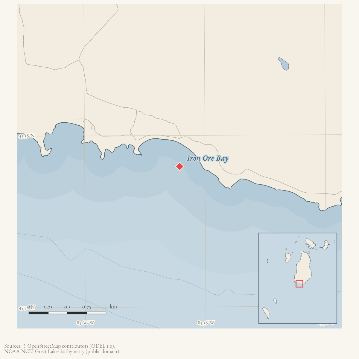
- 45.5764° N, 85.5842° WGoogle Maps: Iron Ore BayDownload KML
- Eras
- Modern era
- Concepts
- environmentshipwreckstourismrecreationinfrastructuregovernmenttoponymycommunity
- Within
- Beaver Island
- Media
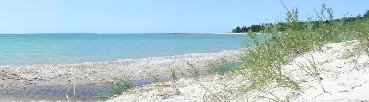
- Beaver Island History Map, 1978 revision · Iron Ore Bay, southern Beaver Island, looking south (2006) · Plat of Big Beaver Island, 1901 · Plat of the south end of Beaver Island, 1930s
Summary
Iron Ore Bay is a named bay at the southern end of Beaver Island, near the Beaver Head lighthouse and Cheyenne Point. The 2023 Beaver Island Master Plan describes rocky gravel shoreline there and lists it among the island’s central birding sites. A public beach was bought there by joint township vote in 1984, and the road along the bay was relocated in 1987 amid a dispute still in litigation as late as 1991; private lakefront lots line the bay’s east side. A 2023 resident survey found its public beach access the most-used, and most wanted improved, park facility in Peaine Township.
Local tradition connects the bay’s name to a wrecked ore-carrying schooner, but the sources disagree on which one: Helen Collar’s research cards name the Milwaukee Belle, the vessel that was the subject of 1965–1968 salvage attempts described below, while a 1991 Charlevoix Courier article names the Betsy Smith, lost in 1882. A 2005–2015 forum discussion shows that local observers also disagreed about whether visible material near the bay was wreckage or old rail and dock construction. Neither the vessel claims nor the forum’s identification of the visible material has been verified against a primary maritime or archaeological record.
History
Iron Ore Bay recurs through the Beaver Beacon from the 1950s as a recreational and reference point: the May 1956 smelt run notice names it alongside the Jordan River and Cables Creek,1 and the September 1961 “Patience and Perseverance” article names the French Bay-to-Iron Ore Bay stretch the hardest section of a multi-year shore walk the Sorensons had begun in 1953.2 In August 1963 diver Al Dobler reportedly found preserved wooden-vessel wrecks at French Bay, Iron Ore Bay, and Sand Bay, though exact locations were “closely guarded.”3 By September 1968 Jim Sawtelle had spent about three years trying to salvage the Milwaukee Belle, reported sunk off the bay; a tug, another boat, and two sets of pontoons were successively lost trying to raise it.4 Youth groups used the bay repeatedly: schoolboy camp-outs in 1968,5 a Brownie Scout day camp in 1979,6 and a fifth-through-eighth-grade lighthouse campout the same year,7 tying the bay to the south-end light station that later housed the Beaver Island Lighthouse School. A November 1973 Beacon poem, “Sunset Iron Ore Bay,” added a literary description of the shoreline.8
The bay’s most sustained record is a 1980s land-use dispute. Peaine Township minutes from December 1983 through March 1984 discuss a possible public purchase of Iron Ore Bay beach frontage;9 a revised two-lot proposal reached $48,500, and on March 15, 1984 voters in both townships approved it by wide margins (St. James 88–13, Peaine 78–18) for 572 feet of frontage, 20-plus acres, and Iron Ore Creek.10 Peaine paid its $12,125 share that May.11 Civic Association volunteers cleaned alewife from the beach that June.12 After high water in 1986 washed out the old two-track road along the bay, the two townships in 1987 backed relocating it onto a wider county easement; the around-island road was reported closed by erosion and the washout there in April 1987,13 and Peaine Township formally abandoned the old road and accepted the new alignment on April 3, 1989.14 A citizen group, “People for the Protection and Preservation of Beaver Island Lakeshore Roads,” sued over the abandonment, and the case was still being amended and argued in court as of November 1990. In January 1991 Edward B. Wojan, managing partner of Island Acreage Company and developer of the bay’s eastern half, published a letter defending the relocation and stating he had transferred 21.1 acres and 574 feet of beach, with Iron Ore Creek, to the two townships below his own cost — a claim of the same transaction described from the developer’s side.15 He also said, without a date, that voters had earlier rejected a millage to buy more of the bay’s frontage, a claim distinct from the documented 1984 vote.
Geography
Iron Ore Bay sits at Beaver Island’s south end, west of Cheyenne Point and near the Beaver Head lighthouse. Iron Ore Creek enters near the bay. The 2024–2028 Peaine Township Recreation Plan lists the jointly owned “Iron Ore Bay Public Access,” on South End Road, at 22 acres with 600 feet of lakefront, a beach, picnic tables, and pit toilets16 — figures close to but not identical with the 572 feet and 20-plus acres reported at the 1984 purchase, and with Wojan’s 574 feet and 21.1 acres, likely reflecting later rounding or additions rather than a single surveyed figure. Private lakefront parcels on the bay’s east side, platted as the Iron Ore Bay Company survey and reached by roads including Betsy Smith Trail and Little Iron Ore Bay Road, have continued to be built and marketed into the 2010s.
Names
Two held sources independently attribute the bay’s name to a wrecked
ore-carrying vessel, but they name different ships. Helen Collar’s Beaver
Island place-names card reads only: “Iron Ore Bay – an ore ship wrecked here
& the cargo washed ashore.”17 A separate Collar biographical card, on Andrew
Roddy, adds that the Milwaukee Belle, which Roddy part-owned and which
caught fire and sank off the Head Light, was “according to Lawrence” the ore
freighter “responsible for the name Iron Ore Bay.”18 That is the same
Milwaukee Belle
salvaged unsuccessfully in 1965–1968 off the bay. A 1991 Charlevoix Courier feature instead says
the schooner Betsy Smith, carrying iron ore, ran aground and sank in 1882
“in what is now called Iron Ore Bay, named after the sunken ship”19 — though
the bay’s name matches the cargo, not the Betsy Smith’s own name, so the
article’s phrasing may conflate the two explanations rather than settle
them. The Betsy Smith’s name otherwise survives locally in Betsy Smith
Trail, a road near the bay. No held source is a primary wreck or maritime
registry record, so which vessel, if either, actually gave the bay its name
is unresolved; confidence on this specific point is contested.
The 1978 History Map combines the Betsy Smith tradition with an additional claim that the Barbarian threw 100 tons of ore overboard in 1882, making the water appear red during southwest winds.20 A contemporary 1886 report found in this review instead records the Barbarian loading gravel.21 That later voyage does not disprove an 1882 ore-lightening episode, but no primary source found supports the map’s tonnage or water-color effect. Those particulars remain map-only.
GNIS carries “Iron Ore Bay” as the sole official form for feature 629081, entered through the same 1976–1981 USGS Geographic Names compilation as neighboring features; the held variant-names table records no spelling variant or superseded name.22
Significance
The 2023 Peaine Township resident survey found Iron Ore Bay’s public beach access the most-visited park facility in the township and the one most respondents wanted improved — a measured indicator, not a claim of general fame, of how central the bay is to current island recreation. Its 1980s acquisition and road-relocation dispute is the most fully documented local land-use controversy tied to any single place in the cluster read for this article.
Open questions
- Which vessel, if either, actually gave Iron Ore Bay its name, and can a primary wreck or registry record settle it?
- How did the 1990–91 lawsuit over the road abandonment conclude?
- Does Wojan’s claim of an earlier, undated, rejected millage refer to a vote distinct from the 1984 election, or is it the same event described imprecisely?
- Can chart-based sources identify the Milwaukee Belle’s casualty position?
See also
Footnotes
-
Beaver Beacon, May 1956, “Smelt Run.” ↩
-
Beaver Beacon, September 1961, “Patience and Perseverance.” ↩
-
Beaver Beacon, August 1963, “Under Water Wonderland.” ↩
-
Beaver Beacon, September 1968, “Shipwreck Salvage.” ↩
-
Beaver Beacon, May 1968, “Camp-outs.” ↩
-
Beaver Beacon, Summer 1979, Brownie Scouts report. ↩
-
Beaver Beacon, October 1979, “Lighthouse Campout.” ↩
-
Beaver Beacon, November 1973, “Sunset Iron Ore Bay.” ↩
-
Peaine Township meetings, Beaver Beacon, February 1984. ↩
-
“Special Election on Purchase of Public Beach,” Beaver Beacon, April 1984. ↩
-
Peaine Township special meeting, Beaver Beacon, June 1984. ↩
-
Beaver Island Civic Association beach cleanup report, Beaver Beacon, July 1984. ↩
-
“From the Beaver,” Beaver Beacon, April 1987. ↩
-
Beaver Beacon, April 1989, “Peaine Township Regular Meeting Held April 3, 1989.” ↩
-
Edward B. Wojan, open letter “To the Editor and to the People of Beaver Island,” Beaver Beacon, January 1991. ↩
-
Peaine Township, 2024-2028 Beaver Island Recreation Plan. ↩
-
Helen Collar Papers, Beaver Island history subject cards, Q-Z, Place Names, Clarke Historical Library. ↩
-
Helen Collar Papers, Beaver Island history subject cards, Q-Z, Biographical (Andrew Roddy), Clarke Historical Library. ↩
-
Laurie Lounsbury, “Fleet of Jeeps and a boat allow tours of Beaver Island,” Charlevoix Courier, circa October 1991. ↩
-
Beaver Island Historical Society, Beaver Island History Map, 1978 revision. ↩
-
Grand Traverse Herald, July 1886, vessel-news extract concerning the schooner Barbarian. ↩
-
U.S. Geological Survey, Geographic Names Information System, Domestic Names (Michigan), retrieved 2026-07-28. ↩
Maps for this place
These Atlas plates provide regional context. They do not establish a precise boundary, current ownership, access right, operating status, or field condition.
- EnvironmentSoils, wetlands, hydrography, and terrain
- GeologyGeneralized geology and landforms
- HydrologyMapped water and wetland context
- AccessMapped routes, facilities, and protected areas
- Land surveyPLSS geometry and historic GLO patent-location context
The dated record
Sources
- GNIS feature 629081; feature class 'Bay'; name entered the federal gazetteer through the USGS's 1976-1981 Geographic Names Phase I compilation (record created 14 April 1980). No variant name for feature 629081 appears in the held GNIS variant-names table.federal · gnis · gnis_names
- Describes rocky gravel at Iron Ore Bay, lists it as central birding site 30, and captions a photo of it among landscapes the plan calls "extremely fragile."
- Names Iron Ore Bay, alongside the Jordan River and Cables Creek, in a notice on an unusually heavy spring smelt run. The holding institution's portal restricts automated access; the archive holds a copy of this issue and can provide it on request.data1 · beaver-island-archive · beaver_beacon · 1956-05_Beaver-Beacon
- Lists the jointly owned "Iron Ore Bay Public Access" on South End Road as 22 acres with 600 feet of lakefront, with a beach, picnic tables, and pit toilets; a 2023 resident survey found it the most-visited park facility in Peaine Township (about 34% of respondents) and the facility most respondents wanted improved (about 48%).planning · beaver_island_master_plan · 2024-2028-beaver-island-recreation-plan-fa1f69af
- Reports two youth camp-outs at Iron Ore Bay.data1 · beaver-island-archive · beaver_beacon · 1968-05_Beaver-Beacon
- Describes a family hiking from Iron Ore Bay to St. James along the island’s west side.data1 · beaver-island-archive · beaver_beacon · 1966-08_Beaver-Beacon
- Places the wreck of the Milwaukee Belle off Iron Ore Bay and describes repeated salvage attempts; it does not claim the wreck lies in the bay itself.data1 · beaver-island-archive · beaver_beacon · 1968-09_Beaver-Beacon
- Describes a winter excursion around Iron Ore Bay to Cheyenne Point, including deer observations and shoreline travel.data1 · beaver-island-archive · beaver_beacon · 1969-02_Beaver-Beacon
- Publishes a poem describing sunset, pines, waves, an offshore boat, and the shoreline at Iron Ore Bay; it is a literary depiction, not a survey or weather observation.data1 · beaver-island-archive · beaver_beacon · 1973-11_Beaver-Beacon
- Names the French Bay-to-Iron Ore Bay stretch as the hardest section of a multi-year Sorenson shore walk begun in 1953, and reports Tom Chmura's one-day, 13.5-hour island circuit.data1 · beaver-island-archive · beaver_beacon · 1961-09_Beaver-Beacon
- Reports Al Dobler finding preserved wooden-vessel wrecks at French Bay, Iron Ore Bay, and Sand Bay, and states exact locations were closely guarded.data1 · beaver-island-archive · beaver_beacon · 1963-08_Beaver-Beacon
- Reports a Brownie Scout day camp at Iron Ore Bay under Mary Palmer and Gwen Zanella. The holding institution's portal restricts automated access; the archive holds a copy of this issue and can provide it on request.data1 · beaver-island-archive · beaver_beacon · 1979-06_Beaver-Beacon
- Publishes student accounts of a fifth-eighth-grade campout at the south-end lighthouse with a trip to Iron Ore Bay. The holding institution's portal restricts automated access; the archive holds a copy of this issue and can provide it on request.data1 · beaver-island-archive · beaver_beacon · 1979-10_Beaver-Beacon
- Reports the March 15, 1984 special election approving a joint St. James/Peaine Township purchase of 572 feet of Iron Ore Bay beach frontage, 20-plus acres, and Iron Ore Creek for $48,500 (St. James 88-13, Peaine 78-18); funding and the legal purchase were still to be completed. The holding institution's portal restricts automated access; the archive holds a copy of this issue and can provide it on request.data1 · beaver-island-archive · beaver_beacon · 1984-04_Beaver-Beacon
- Reports December 12, 1983 and January 5, 1984 Peaine Township minutes discussing the Iron Ore Bay beach-frontage purchase. The holding institution's portal restricts automated access; the archive holds a copy of this issue and can provide it on request.data1 · beaver-island-archive · beaver_beacon · 1984-02_Beaver-Beacon
- Reports Peaine Township's $12,125 payment toward its half of the Iron Ore Bay purchase at its May 3, 1984 special meeting. The holding institution's portal restricts automated access; the archive holds a copy of this issue and can provide it on request.data1 · beaver-island-archive · beaver_beacon · 1984-06_Beaver-Beacon
- Reports volunteers raking alewife into piles at Iron Ore Bay on June 23, 1984, buried by Jim Wojan. The holding institution's portal restricts automated access; the archive holds a copy of this issue and can provide it on request.data1 · beaver-island-archive · beaver_beacon · 1984-07_Beaver-Beacon
- Reports the around-island road closed by erosion at an eastern bluff and a washout near Iron Ore Bay. The holding institution's portal restricts automated access; the archive holds a copy of this issue and can provide it on request.data1 · beaver-island-archive · beaver_beacon · 1987-04_Beaver-Beacon
- Reports Peaine Township resolving that the old county trespass road along Iron Ore Bay was abandoned and discontinued as a public road, and accepting the new South End Road. The holding institution's portal restricts automated access; the archive holds a copy of this issue and can provide it on request.data1 · beaver-island-archive · beaver_beacon · 1989-04_Beaver-Beacon
- Wojan, identifying himself as managing partner of Island Acreage Company and developer of the bay's eastern half, defends the 1987 South End Road relocation against a lawsuit by "People for the Protection and Preservation of Beaver Island Lakeshore Roads," dates the washout that prompted relocation to 1986, states he transferred 21.1 acres and 574 feet of beach with Iron Ore Creek to the two townships below his cost, and separately states, without a date, that voters had earlier rejected a millage to buy more than half the bay's frontage. This is one interested party's account of a contested local dispute, not a court record. The holding institution's portal restricts automated access; the archive holds a copy of this issue and can provide it on request.data1 · beaver-island-archive · beaver_beacon · 1991-01_Beaver-Beacon
- Laurie Lounsbury, "Fleet of Jeeps and a boat allow tours of Beaver Island," Charlevoix Courier, circa October 1991.Reports that the schooner Betsy Smith, carrying iron ore, ran aground and sank off Beaver Island in 1882 "in what is now called Iron Ore Bay, named after the sunken ship," and that the wreck (by 1991) rested about four feet below the surface. The exact issue date could not be confirmed from the bound-volume OCR; placement next to an October 24, 1991 city-council record and a November 5 election notice indicates circa October-November 1991. No public copy of this file is known; the archive holds one and can provide it on request.data1 · beaver-island-archive · charlevoix · charlevoixcourie1991unse
- Forum participants debated whether visible material near Iron Ore Bay was Betsy/Bessie Smith wreckage, former rail or ore-dock cribbing, or salvage equipment. A 2015 participant supplied approximate coordinates, but the discussion is informal and internally inconsistent; it is retained as evidence of local interpretations and a research lead, not confirmation of wreck identity, date, or exact position.forum · www.beaverislandforum.com · 00 · t000415
- A resident seeking a wreck photograph reproduced a shipwreck-history entry for the schooner Bessie/Betsy Smith: official number 2852, 1873 loss, Beaver Island, storm, and iron-ore cargo. Replies explicitly note spelling variation and direct readers to museum resources. This is a secondary web-history transcription and local research lead, not a primary vessel registry or archaeological identification; it reinforces that the Betsy/Bessie naming remains contested.forum · www.beaverislandforum.com · 04 · t004008
- Participants identified a metal winch visible near the shoreline at Iron Ore Bay, observed that water was slightly higher than the prior year but still low compared with earlier years, and recalled the object as present for at least thirty years. These are dated local observations and recollections, not a measured water-level series or an archaeological identification of the winch.forum · www.beaverislandforum.com · 00 · t000376
- The Place Names card reads, in full: "Iron Ore Bay - an ore ship wrecked here & the cargo washed ashore."web · collar_subject_cards_q-z
- Records that the Milwaukee Belle, part-owned by Andrew Roddy, caught fire and sank off the Head Light, and that "according to Lawrence she was an ore freighter, the one that wrecked & was responsible for the name Iron Ore Bay." A local-informant attribution, not a primary maritime record.web · collar_subject_cards_q-z
- Described in this archive: Beaver Island History Map, 1978 revision.Attributes the name jointly to ore in the wrecked Betsy Smith and 100 tons thrown from the Barbarian in 1882, said to redden the water in southwest winds. No primary source inspected confirms the amount, episode, or color effect.
- Contemporary report places the Barbarian loading gravel in 1886. It neither confirms nor disproves an 1882 ore-lightening episode, but shows the vessel carried a different bulk cargo in another documented trip.
- Beaver Island Forum, “Thanks, County Road Guys!”, January 27–28, 2012.Residents thanked county road-crew members for returning rocks to place at Iron Ore Bay for erosion control. This is a resident observation and community acknowledgment, not a county work order or engineering record; the post does not specify the work date, scope, or responsible agency.forum · www.beaverislandforum.com · 04 · t004549
Added 28 July 2026 · revised 7 August 2026. Recent changes
Cite this article
Beaver Island Archive, “Iron Ore Bay”, https://beaverislandarchive.org/places/iron-ore-bay/, accessed [date], citing U.S. Geological Survey, Geographic Names Information System, Domestic Names (Michigan), retrieved 2026-07-28. (and 28 further sources listed on the page).
Last revised 2026-08-07. Fill in [date] with the date you read it — this page is static and cannot know that.