

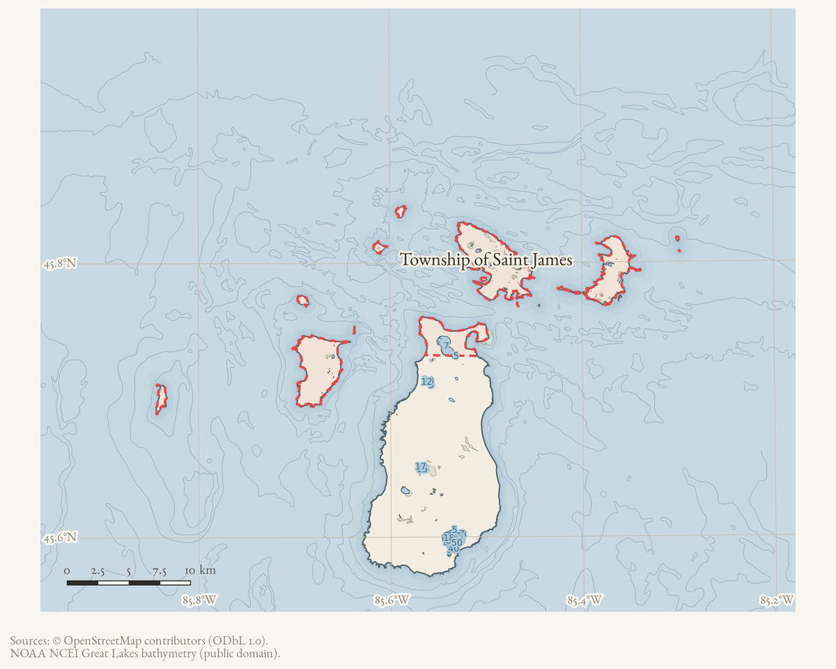
- Coordinates
- 45.7884° N, 85.5868° WGoogle Maps: Township of Saint JamesDownload KML
- Eras
- Strang eraModern era
- Concepts
- toponymyStrang eragovernancedemographysettlement
- Within
- Beaver Island · Beaver Island archipelago
- Media
- 1940 census enumeration district descriptions, Charlevoix County: ED 15-23, 15-24, 15-25
Summary
The Township of Saint James is one of two civil townships covering Beaver Island — together with Township of Peaine, the two cover the whole island and no mainland territory. It takes its name from the harbor village of Saint James, the island’s principal settlement and, under James Jesse Strang’s Latter Day Saint settlement (1847–1856; kingdom from 1850), the seat of his self-organized county government.
History
The whole archipelago was first organized as a single civil township, Peaine, in 1847.1 The Township of Saint James represents a later division from that original unit. An official Peaine Township historical summary dates its formation to 13 December 1899, by the Charlevoix County Board of Supervisors, following a petition; the 1978 Historical Map prints “St. James Twp., 1900-”, which reads as that action rounded to the first full year or the first separate federal census rather than as a competing date.
That 1899 date is one step removed from the primary record. The held summary cites the county proceedings at pages 749-750, and those pages have not been obtained and read here. Its relationship to the 1897 vacation of Galilee Township is also unestablished.
One caution follows from the sequence: census material headed “St. James” before 1900 must not be read automatically as this civil township. It can refer to the harbor settlement or to an enumeration label, and the township did not exist under that name until the county acted. Its name derives directly from the harbor village: per a settler’s-daughter memoir, “the county seat and post office was at the harbor, named in honor of the King ‘Saint James’” — James Jesse Strang, who took the title King James at his 1850 coronation.2
The township’s population was 307 in 2000, rose to 365 in 2010, then fell to 259 in 2020.3 Earlier counts, back to 120 in 1900, are set out in the demography survey. The 2023 American Community Survey 5-year estimate reports a higher total population (374) alongside 263 of 436 housing units recorded as vacant and a median age of 59.5. Read those as a rolling estimate with wide margins for a population this small, not as a literal count comparable to the decennial census.
The forum archive also preserves a cluster of 2021 staffing and succession notices: the township sought a supervisor, a trustee, and a planning and administrative assistant. Those notices document recruitment and intended appointment processes, not the eventual officeholders, hires, or completed planning work.
Geography
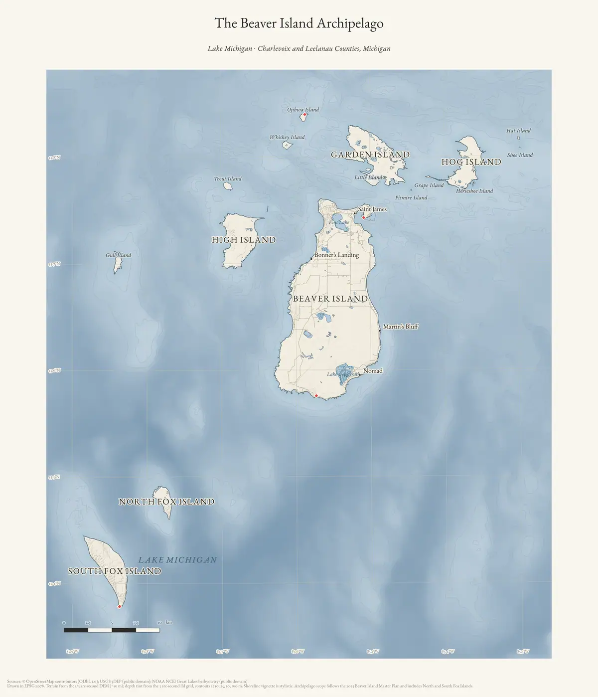
Saint James Township is the smaller of the two townships on land and by far the larger in reach. Measured from the State of Michigan’s minor-civil-divisions layer, it covers 21.0 square miles (13,432 acres) against Peaine’s 53.6 square miles (34,297 acres) — but where Peaine lies wholly within Beaver Island, Saint James is a multi-part boundary spanning roughly 43 km of longitude, from 85°50′W to 85°18′W.
It takes in the harbor and the northern part of Beaver Island and the whole of the outer archipelago. Thirteen named islands fall within it:
| Garden Island · High Island · Hog Island | the three largest outer islands |
| Whiskey Island · Trout Island · Gull Island | northern outliers |
| Hat Island · Shoe Island · Pismire Island | small islets |
| Grape Island · Little Island · Ojibwa Island | with the northern part of Beaver Island itself |
That distinction matters for reading almost any township record. A Saint James assessment roll, school district, or road list may concern ground a boat-ride away from the harbor, and the surveys of Hat, Shoe, Trout and Whiskey islands sit in the same township’s paperwork as the village waterfront.
On the coordinate. This article previously gave the township’s position as “the northern portion of Beaver Island, per its GNIS coordinate centroid (45.788°N, 85.587°W).” That point is in open water — 3.8 km from Beaver Island and 3.2 km from Whiskey Island — and it does not lie inside the township’s own polygon in the State layer. It is a GNIS representative point for a civil division, which is a filing convenience, not a location, and it cannot be evidence for what the township covers. The polygon’s measured centroid is 45.7666°N, 85.5381°W. Corrected 8 August 2026.
Names
No former or alternate name is recorded for the township in sources held; its name has been stable since its (undated) separation from the original Township of Peaine.
Significance
The township contains Saint James harbor, and with it the island’s seat of government and its principal point of contact with the mainland: the post office, the Life-Saving Service station in 1902 (see Saint James), and, today, the ferry and airline services.
Open questions
- The 13 December 1899 Charlevoix County Board of Supervisors petition, resolution and boundary description have not been obtained; the date rests on an official Peaine Township summary citing county pages 749-750, not on those pages read directly.
- The exact legal relationship between the 1897 vacation of Galilee Township, Peaine Township, and the 1899 formation of Saint James is not established.
- The lower 2020 population (259) relative to 2010 (365) has not been explained
from any source held — whether it reflects genuine depopulation, a Census
methodology change (2020 used a different decennial instrument,
dec/dhc, than 2010’ssf1), or another cause is an open question.
See also
Footnotes
The dated record
Sources
- GNIS feature 1627029; feature class 'Civil'.federal · gnis · gnis_names
- 'In 1847 the Beaver Islands were erected into the township of Peaine' — the whole archipelago's first civil organization, before the later division that produced this township. See place/township-of-peaine for the fuller account.
- 'The county seat and post office was at the harbor, named in honor of the King "Saint James."' The harbor village that gives this township its name.
- St. James Township population 307 (2000), 365 (2010), 259 (2020).demographics · township_population_series
- St. James Township total population 374, 436 total housing units (263 vacant), median household income $66,806, median age 59.5, median home value $286,400.demographics · acs2023_townships
- Retrieved 2 August 2026 from the State's ArcGIS OpenData service. Source of the areas, the boundary extent and the island list in Geography below, each measured from the layer's own geometry in EPSG:4326.state · michigan · minor_civil_divisions
- Beaver Island Archive, *The Beaver Island Archipelago* (archive-drawn plate). CC BY 4.0 for the drawing; underlying data under its own terms (see credit).Reference map of the whole archipelago, which is the township's actual reach: as the Geography section above sets out, Saint James takes in thirteen named islands and not merely the northern part of Beaver Island. Credit: Drawn from the archive's own data in EPSG:3078. Map data © OpenStreetMap contributors (ODbL 1.0); terrain USGS 3DEP (public domain); bathymetry NOAA NCEI (public domain). No public copy of this file is known; the archive holds one and can provide it on request.output · maps · archipelago_overview
- States that Charlevoix County supervisors formed St. James Township on December 13, 1899, following a petition; the underlying county pages 749-750 have not yet been inspected directly.
- Described in this archive: Beaver Island History Map, 1978 revision.Prints “St. James Twp., 1900-.” This is treated as census-era shorthand, not as evidence against the December 1899 county formation date.
Added 28 July 2026 · revised 7 August 2026. Recent changes
Cite this article
Beaver Island Archive, “Township of Saint James”, https://beaverislandarchive.org/places/township-of-saint-james/, accessed [date], citing U.S. Geological Survey, Geographic Names Information System, Domestic Names (Michigan), retrieved 2026-07-28. (and 8 further sources listed on the page).
Last revised 2026-08-07. Fill in [date] with the date you read it — this page is static and cannot know that.
BibTeX for “Township of Saint James”RIS for “Township of Saint James”