

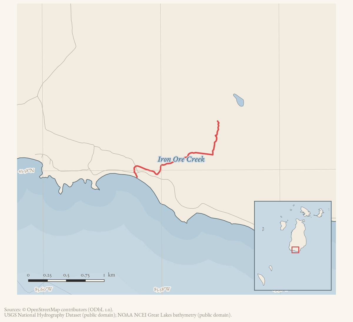
- Coordinates
- 45.5794° N, 85.5840° WGoogle Maps: Iron Ore CreekDownload KML
- Concepts
- environmentfishingconservationtourism
- Within
- Beaver Island
- Media
- Beaver Island History Map, 1978 revision
Summary
Iron Ore Creek is a named stream on the south end of Beaver Island, roughly 1.988 km long in the held hydrography, running to its mouth at Iron Ore Bay on Lake Michigan.1 The 2023 Beaver Island Master Plan designates it a trout stream supporting resident native brook trout and naturally reproducing juvenile steelhead, alongside migratory runs of rainbow trout, brown trout, and sucker species.2 A Michigan DNR fisheries survey conducted in July 2023 collected brook trout from 1 to 9 inches in the creek and noted low water levels, consistent with a 1955 report of a comparatively light spring smelt run there.34 Between 2009 and 2011, a multi-agency project funded in part by the Charlevoix County Community Foundation replaced a failing road crossing near the creek’s mouth to improve fish passage between Lake Michigan and the creek — Conservation Resource Alliance’s first completed infrastructure project on Beaver Island.56
Geography
GNIS positions Iron Ore Creek at 45.5794479° N, 85.5839678° W on the “Beaver Island South” quadrangle.7 The project’s stream crosswalk matches this feature to a single held National Hydrography Dataset named flowline of approximately 1.988 km, whose downstream end sits close to the GNIS point, consistent with a creek mouth near Iron Ore Bay.1 The 2011 Charlevoix Courier account of the road-crossing replacement project independently confirms this geography, describing the “jasper-tinted” creek emptying into Iron Ore Bay through a road crossing situated “immediately adjacent to the mouth.”6 The stream’s 50 m context corridor, per the crosswalk, crosses dune sand and lacustrine sand and gravel, Deer Park-Dune land and Tawas-Carbondale soil associations, Freshwater Forested/Shrub Wetland and Riverine wetland classes, and reconstructed beech-sugar maple-hemlock forest and mixed-conifer-swamp circa-1800 land cover — a working research overlay, not a surveyed channel boundary.1
Fisheries and habitat
Local and state fisheries evidence for the creek spans seven decades. In May 1955, a Beacon nature column recorded that “a smaller number of the silvery fish come into Iron Ore Creek” during that spring’s smelt run, compared with the Jordan River and Cables Creek.4 That August, Conservation Department staff surveying Game Club-requested projects found Iron Ore Creek to have “suitable temperature for brook trout - but not enough water this year for planting” – the earliest held assessment of the creek’s trout suitability, and evidence that its low water levels, also recorded by the 2023 DNR survey, are a recurring rather than new condition.8 In April 1965, the Beaver Island Game Club proposed building dams in the creek “to deepen the water and provide good habitat for game fish” ahead of a planned trout stocking, alongside the same plan for Cables Creek; the source documents the proposal, not its completion.9 The 2023 Master Plan classifies Iron Ore Creek, alongside the Jordan River and Cables Creek, as a designated trout stream, and specifically credits Iron Ore Creek and Cables Creek with resident native brook trout and naturally reproducing juvenile steelhead.2 A Michigan DNR fisheries survey in July 2023, reported in the Northern Islander the following February, sampled the creek and collected brook trout ranging from 1 to 9 inches, again under low water conditions.3
The 2009-2011 crossing replacement
The clearest documented infrastructure history for the creek concerns its road crossing near the mouth. Charlevoix County Community Foundation records for 2009 list two grants to Conservation Resource Alliance “to replace a road/stream crossing on Iron Ore Creek” — $851 from the Adams Fund and $1,449 from the Beaver Island Enrichment Fund, totaling $2,300.5 A 2011 Charlevoix Courier follow-up describes the completed work: for years the creek had emptied into Iron Ore Bay through “a combination of four inappropriately sized culverts failing in structural integrity and poor placement,” and the sole road crossing — sited immediately next to the creek’s mouth — was replaced at a total cost of $34,350, funded through a partnership of several organizations including Conservation Resource Alliance and the U.S. Fish and Wildlife Service (the held OCR text of the article breaks off before naming the remaining partners). The stated purpose was to improve passage for “coaster” brook trout moving between Lake Michigan and upstream stretches of the creek.6 The Beacon called it Conservation Resource Alliance’s “first-ever infrastructure project completed on Beaver Island.”6
Public ownership and access, 1984-1992
The clearest civic history tied to the creek concerns public ownership of its mouth. On March 15, 1984, voters in St. James and Peaine Townships approved, by 88-13 and 78-18, a joint township purchase of “Iron Ore Creek on Iron Ore Bay” – 572 feet of beach frontage and more than 20 acres, including all of Iron Ore Creek itself – for $48,500.10 The Beacon’s report frames the purchase as a defense against losing public beach access to private development, citing a contemporaneous account of beach privatization in Nantucket, Massachusetts, and calling Iron Ore Bay “a favorite stopping spot and swimming beach” that would now “always be open to public use.”10 That August, 3,000 brook trout were planted across roughly twenty beaver-dam and pond sites from Cornelius Swamp to Iron Ore Creek, mostly concentrated around Lake Geneserath; the report does not specify how many, if any, went into Iron Ore Creek itself.11
Road access to the new public land was contested for years afterward. A June 1987 township board report records the Iron Ore Bay road washed out between the lighthouse and Iron Ore Creek, with cost-sharing proposed among the Road Commission, developers, and township.12 The county’s 1987 abandonment of the road section between Iron Ore Creek and the Charlevoix Public School property drew a lawsuit from the “People for the Protection and Preservation of Beaver Island Lakeshore Roads” against the Charlevoix County Road Commission, which Peaine Township’s board reaffirmed supporting in July 1990.13 By November 1992, township-funded improvements had added a parking area, an outhouse “set back in the fringe of the pine woods adjacent to Iron Ore Creek,” a volleyball net, and boundary markers to the roughly 500-foot public beach.14
As a local landscape reference
Beyond its fisheries record, Iron Ore Creek recurs in local reporting simply as a place-name anchor for travel on the south end of the island. In December 1962, a hunter who became lost had told his companion he would come out at Nomad later that day after entering the woods at Iron Ore Creek — evidence of the creek as a starting point for a route toward Nomad and Lake Geneserath, not a description of the creek itself.15
Significance
Iron Ore Creek is a small stream with an outsized civic record for its size: the 1984 township purchase secured public beach access at its mouth against the same development pressure the Beacon saw closing beaches elsewhere, and the disputes and improvements that followed through 1992 show that access being actively defended and maintained rather than simply declared. Its trout-fishery record, running from an August 1955 Conservation Department assessment to the 2023 DNR survey, is one of the more continuously documented small streams on the island.
Open questions
- What surveys or maps document changes in the creek channel, water levels, and outlet near Iron Ore Bay before the 2009-2011 culvert project?
- Was the 1965 Game Club dam and trout-planting proposal implemented, and can any resulting habitat change be distinguished from the creek’s later, independently documented fisheries condition?
- Who were the remaining partner organizations in the 2009-2011 crossing replacement, beyond Conservation Resource Alliance and the U.S. Fish and Wildlife Service?
- Does “coaster” brook trout recruitment from Lake Michigan into Iron Ore Creek, the stated goal of the 2011 project, show up in any fisheries survey since?
See also
Footnotes
-
Project-generated named stream crosswalk (2026),
data/research/places/archipelago_stream_crosswalk.json; see Named stream crosswalk for the Beaver archipelago, 2026. ↩ ↩2 ↩3 -
Beaver Island Master Plan, 2023 update,
data/books/internet_archive/beaver-island-master-plan-20231113/. ↩ ↩2 -
Northern Islander, February 2024, “MDNR 2023 Beaver Island Fisheries Survey.” ↩ ↩2
-
Charlevoix Courier, 2009, “Community foundation awards $390,772.” ↩ ↩2
-
Charlevoix Courier, 2011, “Grant will help inventory road/stream crossings.” ↩ ↩2 ↩3 ↩4
-
USGS GNIS, Domestic Names (Michigan), feature 1618185,
data/federal/gnis/gnis_names.geojson. ↩ -
Beaver Beacon, September 1955, Conservation Department survey report. ↩
-
Beaver Beacon, April 1965, “Game Club Plans Projects.” ↩
-
Beaver Beacon, August 1984, trout-stocking report. ↩
-
Beaver Beacon, June 1987, township board minutes (road washout). ↩
-
Beaver Beacon, July 1990, township board minutes (road litigation). ↩
-
Beaver Beacon, November 1992, “Iron Ore Bay Public Beach” report. ↩
-
Beaver Beacon, December 1962, “Lost.” ↩
The dated record
Sources
- GNIS feature 1618185; feature class 'Stream'; map 'Beaver Island South'; date_created 1 July 1991. No variant-name row exists for this feature in the national variant-names table, and no former or alternative name is attested in any source held here.federal · gnis · gnis_names
- No row for feature 1618185 exists; GNIS records no variant or superseded name for Iron Ore Creek.federal · gnis · gnis_variant_names
- Identifies Iron Ore Creek as a designated trout stream; says it supports resident native brook trout and naturally reproducing juvenile steelhead, with migratory runs of rainbow trout (steelhead), brown trout, white sucker, longnose sucker, and occasionally Chinook and Coho salmon, alongside Jordan River and Cables Creek. A separate passage describes Iron Ore Bay as "a unique shoreland area on the southern coast where Iron Ore Creek, a coldwater creek, runs into Lake Michigan."
- Read directly. Reports that the Michigan DNR conducted fisheries surveys in July 2023 on two inland lakes and several streams including Iron Ore Creek; at Iron Ore Creek, brook trout were collected ranging in size from 1 to 9 inches, and low water levels were again documented. Attributed here to the July 2023 MDNR survey, not to the newspaper itself.
- Reports that a smaller number of smelt entered Iron Ore Creek during the spring run, compared with the Jordan River and Cables Creek.data1 · beaver-island-archive · beaver_beacon · 1955-05_Beaver-Beacon
- The held four-page issue scan is paired with the OCR source and confirms the published notice or report; it does not expand the source-specific identity, event, or outcome claims.data1 · beaver-island-archive · scans · beaver_beacon · issues · 1955-05_Beaver-Beacon
- Reports a plan to build dams in Iron Ore Creek to deepen water and improve habitat before a trout planting; it documents a proposal, not proof that the work occurred.data1 · beaver-island-archive · beaver_beacon · 1965-04_Beaver-Beacon
- The held seven-page issue scan is paired with the OCR source and confirms the published notice or report; it does not expand the source-specific identity, event, or outcome claims.data1 · beaver-island-archive · scans · beaver_beacon · issues · 1965-04_Beaver-Beacon
- Uses Iron Ore Creek as the starting point for a hunter’s route toward Nomad and Lake Geneserath, documenting the creek as a local landscape reference.data1 · beaver-island-archive · beaver_beacon · 1962-12_Beaver-Beacon
- The held eight-page issue scan is paired with the OCR source and confirms the published notice or report; it does not expand the source-specific identity, event, or outcome claims.data1 · beaver-island-archive · scans · beaver_beacon · issues · 1962-12_Beaver-Beacon
- Charlevoix Courier, 2009, "Community foundation awards $390,772."Read directly. Lists two Charlevoix County Community Foundation grants to Conservation Resource Alliance "to replace a road/stream crossing on Iron Ore Creek": $851 from the Adams Fund and $1,449 from the Beaver Island Enrichment Fund, together $2,300. No public copy of this file is known; the archive holds one and can provide it on request.data1 · beaver-island-archive · charlevoix · charlevoixcourie2009unse
- Charlevoix Courier, 2011, "Grant will help inventory road/stream crossings."Read directly. Reports that the $2,300 Community Foundation grant funded Conservation Resource Alliance's "first-ever infrastructure project completed on Beaver Island," replacing a failing road crossing "immediately adjacent to the mouth" of the "jasper-tinted" Iron Ore Creek, where it had emptied into Iron Ore Bay through four undersized, structurally failing culverts. The total replacement cost was $34,350, funded by a multi-organization partnership (Conservation Resource Alliance, U.S. Fish and Wildlife Service, and others the held OCR text cuts off at "See GRANT, page 3"), and was intended to improve passage for 'coaster' brook trout moving between Lake Michigan and upstream Iron Ore Creek. No public copy of this file is known; the archive holds one and can provide it on request.data1 · beaver-island-archive · charlevoix · charlevoixcourie2011unse
- Reports Conservation Department staff visiting August 8-9, 1955 to survey Game Club-requested projects; states "Iron Ore Creek has suitable temperature for brook trout - but not enough water this year for planting," an August assessment predating and complementing the May 1955 smelt-run note above. The holding institution's portal restricts automated access; the archive holds a copy of this issue and can provide it on request.data1 · beaver-island-archive · beaver_beacon · 1955-09_Beaver-Beacon
- Reports a March 15, 1984 special election in which St. James and Peaine Township voters approved a joint township purchase of "Iron Ore Creek on Iron Ore Bay," including 572 feet of beach frontage and 20-plus acres, for $48,500, to keep the area a public beach; votes were 88-13 (St. James) and 78-18 (Peaine). Frames the purchase against a fear of losing public beach access, citing a contemporaneous article about Nantucket, Massachusetts. The holding institution's portal restricts automated access; the archive holds a copy of this issue and can provide it on request.data1 · beaver-island-archive · beaver_beacon · 1984-04_Beaver-Beacon
- Reports 3,000 brook trout planted in beaver dams and deep ponds across roughly twenty sites from Cornelius Swamp in the north to Iron Ore Creek in the south, most concentrated around Lake Geneserath; does not specify how many, if any, went into Iron Ore Creek itself. The holding institution's portal restricts automated access; the archive holds a copy of this issue and can provide it on request.data1 · beaver-island-archive · beaver_beacon · 1984-08_Beaver-Beacon
- Reports the Iron Ore Bay road washed out from the lighthouse to Iron Ore Creek, and township discussion of cost-sharing (Road Commission 50 percent, developers 25 percent, township 25 percent) for a replacement route. The holding institution's portal restricts automated access; the archive holds a copy of this issue and can provide it on request.data1 · beaver-island-archive · beaver_beacon · 1987-06_Beaver-Beacon
- Reports litigation by "People for the Protection and Preservation of Beaver Island Lakeshore Roads" against the Charlevoix County Road Commission over the 1987 abandonment of the section of Iron Ore Bay Road between Iron Ore Creek and the Charlevoix Public School property; Peaine Township reaffirmed its support for the abandonment. The holding institution's portal restricts automated access; the archive holds a copy of this issue and can provide it on request.data1 · beaver-island-archive · beaver_beacon · 1990-07_Beaver-Beacon
- Reports 1992 township-funded improvements at the Iron Ore Bay public beach -- a parking area, an outhouse "set back in the fringe of the pine woods adjacent to Iron Ore Creek," a volleyball net, and boundary markers -- on the roughly 500-foot beach purchased in 1984. The holding institution's portal restricts automated access; the archive holds a copy of this issue and can provide it on request.data1 · beaver-island-archive · beaver_beacon · 1992-11_Beaver-Beacon
- Project-generated named stream crosswalk (2026).Matches GNIS feature 1618185 to one held NHD named flowline of approximately 1.988 km, whose mapped endpoint sits close to the GNIS point, near Iron Ore Bay. Its 50 m context corridor intersects dune sand and lacustrine sand/gravel (Quaternary geology), Deer Park-Dune land and Tawas-Carbondale soil associations, Freshwater Forested/Shrub Wetland and Riverine NWI classes, and reconstructed beech-sugar maple-hemlock forest and mixed-conifer-swamp circa-1800 cover. The corridor is not a surveyed channel boundary. No public copy of this file is known; the archive holds one and can provide it on request.research · places · archipelago_stream_crosswalk
Added 28 July 2026 · revised 4 August 2026. Recent changes
Cite this article
Beaver Island Archive, “Iron Ore Creek”, https://beaverislandarchive.org/places/iron-ore-creek/, accessed [date], citing U.S. Geological Survey, Geographic Names Information System, Domestic Names (Michigan), retrieved 2026-07-28. (and 18 further sources listed on the page).
Last revised 2026-08-04. Fill in [date] with the date you read it — this page is static and cannot know that.