

- Coordinates
- 45.6341° N, 85.5855° WGoogle Maps: Greene’s LakeDownload KML
- Eras
- Modern era
- Concepts
- toponymyenvironmentwetlandsconservationgeologysoilshydrologyforeststreesvegetationplantswildlifeanimalsbirdsstewardshipinvasive-species
- Within
- Beaver Island
- Media
- Beaver Island History Map, 1978 revision · Plat of Big Beaver Island, 1901 · Plat of the north end of Beaver Island, 1930s
Summary
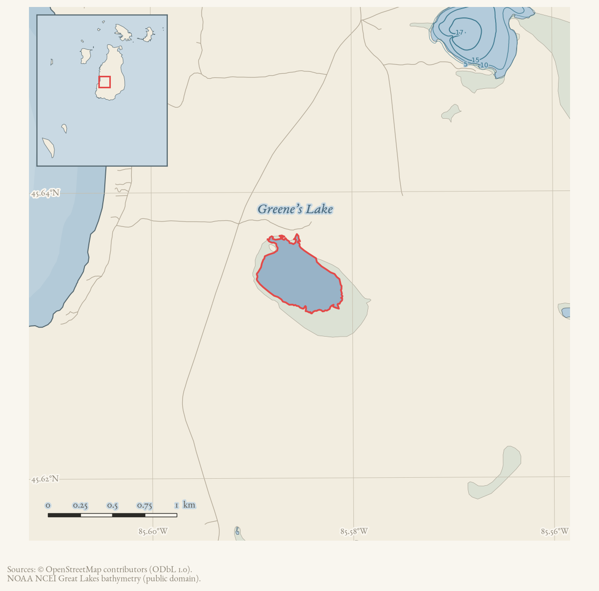
Greene’s Lake is a named inland lake in Beaver Island’s southwestern interior. GNIS records the variants “Green Lake,” “Greene Lake,” and “Greens Lake,” while its feature-history note associates the name with “Big Neal” Greene; that etymology remains a GNIS-derived claim pending a separate local biographical source.
Collar’s biographical cards corroborate the association while exposing why the genealogy should remain qualified. One Neal Green entry simply says “White Dan’s uncle.” A neighboring Neil Green entry says he lived at Green’s Lake but then preserves three conflicting informant relationships: cousin, no relation, or uncle who came later. The name origin is therefore well attested as local tradition; the exact identity and kinship of “Big Neal” are not resolved.
The 2023 Beaver Island Master Plan describes the lake as approximately 62 acres, shallow, and often frozen completely in winter. It emphasizes the rich wetlands around the lake and says that Michigan DNR owns most of the shoreline. The plan’s broader fisheries discussion says the lake is part of a bog complex and inhospitable for most fish but popular with herpetofauna. It does not establish the date or terms of DNR acquisition.
History
The GNIS feature-history note attributes the name to “Big Neal” Greene, an early settler; a photographed historical-map glossary circulated within the island community independently gives the same attribution and adds that he was “an uncle to the Dan Greenes who came over later,” tying the lake’s name to the broader Greene family associated with nearby Greene’s Bay. This detail is a community-compiled secondary source and has not been checked against a primary genealogical or land record.
By 1958 the lake was already a fixture of the island’s hunting-trail network: an October 1958 Beacon report on the Beaver Island Game Club credits the club with opening and repairing roads and trails for hunters and other visitors, including “the road from Greens Lake to the Fire Tower,” alongside work at Angeline’s Bluff, Greens Bay Bluff, and a road to Wilson’s Orchard at Nomad. The 2019-2048 Michigan DNR/Peaine Township public-recreation lease names a Greene’s Lake Boat Access among five leased sites, showing continued public recreational access into the 21st century, though the lease does not by itself establish when the DNR first acquired the surrounding land the 2023 Master Plan describes.
The lake also anchors a qualified lumbering claim. The 1978 History Map places “Tony’s Mill” nearby and calls it Tony Wojan’s second mill in 1942. Two later Beacon retrospectives reverse that sequence: one says Wojan came to the island in 1935 to run a mill first at Greene’s Lake and then at the harbor; an oral-history excerpt likewise recalls working at the Greene’s Lake mill before it moved downtown the following year. These sources support a Wojan sawmill in the Greene’s Lake area, but they do not resolve its exact year or footprint, and they contradict the map’s “second mill” wording. No point geometry is inferred from the illustrated map.
Ecological profile
The 2017 MNFI records distinguish three connected natural-community settings around the Greene’s Lake basin: a 40-acre bog (EO 20442, rank AB, G3G5/S4; report p. 16), a 121-acre poor conifer swamp (EO 20688, rank AB, G4/S4; p. 122), and a 134-acre rich conifer swamp (EO 20689, rank BC, G4/S3; pp. 133–134). The bog lies on poorly drained lakeplain with deep sphagnum peat over sand. It is weakly minerotrophic in places, with localized groundwater or surface-water enrichment, and has an inundated sphagnum mat with pronounced hummock-and-hollow microtopography on the eastern shore. The source describes leatherleaf, bog rosemary, bog willow, sedges, cranberry, tamarack, mountain holly, and winterberry in the bog margins.
The adjacent poor conifer swamp occupies part of a former lake basin and is described as a peatland formed through lake filling or terrestrialization. Its deep fibric-to-hemic peat is acidic (reported pH 4.5), while groundwater seepage increases minerotrophic influence and floristic diversity along margins and narrows. The canopy is dominated by tamarack and black spruce, with scattered white pine; a cored black spruce was estimated at 112 years. The record also notes late-spring inundation, hummock-and-hollow moisture gradients, and a clay-rich till landform that likely impedes drainage.
The rich conifer swamp adds a different substrate and age structure: variable peat from about 30 cm to more than one metre, slightly acidic to alkaline (pH 6.8–8.0) over alkaline sands (pH 7.8–8.0). Northern white-cedar dominates, with tamarack in wetter, more open areas and black ash, red maple, black spruce, yellow birch, white pine, and hemlock as associates. Individual cedars were estimated at approximately 150, 159, 180, and more than 210 years; a yellow-birch snag exceeded 60 cm. Windthrow, coarse woody debris, and scattered cut stumps document disturbance and past logging.
The source records beaver activity north of the rich conifer swamp and deer trails, scat, and winter browse; it interprets the area as likely deer-yard habitat and says browse may be limiting cedar regeneration. Recommendations include retaining an intact natural buffer, monitoring invasive species and deer browse, reducing local deer densities, and allowing natural processes to continue. These observations belong to adjacent MNFI occurrences and should not be read as a complete survey of Greene’s Lake or a current wetland delineation or legal boundary.
The same MNFI 1999 progress report records one Common Loon pair at Greene’s Lake during its visited-lake observations. This adds a dated bird observation to the later natural-community records, but it does not establish nesting, population size, continued occupancy, or a complete lake-wide wildlife inventory.
Significance
Greene’s Lake illustrates how a small interior lake accumulates layered documentation without ever becoming the subject of a single dedicated source: its name is attested only in GNIS records and a community-sourced map glossary; its mid-20th-century use is attested by a single Game Club trail report; its ecology is documented in detail, but only as three adjacent MNFI natural-community occurrences rather than a survey of the lake itself; and its ongoing public status rests on a DNR lease document that names it once among five sites. Taken together these sources describe a lake embedded in a bog-and-swamp complex significant enough to attract sustained state ecological interest (three distinct MNFI occurrences totaling nearly 300 acres in the surrounding basin) while remaining, in the human record, a place named after a settler about whom almost nothing else is documented here.
Open questions
- Can “Big Neal” Greene be identified in census, land, or Journal of Beaver Island History records, beyond the GNIS feature history and the community-sourced map glossary?
- What wetlands and herpetofauna surveys support the Master Plan’s ecological description?
- When did Michigan DNR acquire most of the shoreline, and what public access exists today beyond the leased boat-access site?
If you can answer any of these, or correct anything above, the archive wants to hear it — see Corrections.
See also
Maps for this place
These Atlas plates provide regional context. They do not establish a precise boundary, current ownership, access right, operating status, or field condition.
- EnvironmentSoils, wetlands, hydrography, and terrain
- GeologyGeneralized geology and landforms
- HydrologyMapped water and wetland context
- AccessMapped routes, facilities, and protected areas
- Land surveyPLSS geometry and historic GLO patent-location context
The dated record
Sources
- GNIS feature 627366; feature class 'Lake'.federal · gnis · gnis_names
- Feature 627366 description names “Big Neal” Greene as an early settler.federal · gnis · gnis_feature_descriptions
- Variant names: Green Lake; Greene Lake; Greens Lake.federal · gnis · gnis_variant_names
- Describes Greene’s Lake as about 62 acres, shallow, often frozen solid, surrounded by rich wetlands, and largely bordered by Michigan DNR land.
- Names Greene’s Lake Boat Access as one of five DNR-leased Peaine public-recreation sites. It does not establish a current legal boundary, specific improvement consent, current access, or current condition.research · island_governance · peaine-lake-geneserath-dnr-lease
- Project-generated MNFI 2017 soil, vegetation, and wildlife crosswalk, preserving MNFI Report 2017-11, Greene’s Lake and Greene’s Lake Swamp occurrences, report pp. 16, 122, and 133–134.Described in this archive: MNFI soil, vegetation, tree, and wildlife crosswalk, 2017.The records describe adjacent bog and swamp occurrences in the Greene’s Lake basin, not a surveyed boundary for the named lake itself. No public copy of this file is known; the archive holds one and can provide it on request.research · island_farming · crosswalks · mnfi_soil_vegetation_wildlife_crosswalk
- Bog page evidence; the held crosswalk also preserves page images for the poor and rich conifer swamp records (report pp. 122 and 133–134).research · island_farming · evidence · mnfi-report-2017-11-page-0016-greenes-lake-bog
- Visual page evidence held with provenance sidecar; the image anchors the 121-acre occurrence and does not establish modern geometry or current condition.research · island_farming · evidence · mnfi-report-2017-11-page-0122-greenes-lake-poor-conifer-swamp
- Visual page evidence held with provenance sidecar; the image anchors the 134-acre occurrence and does not establish modern geometry or current condition.research · island_farming · evidence · mnfi-report-2017-11-page-0133-greenes-lake-rich-conifer-swamp
- MNFI, Biological Inventory For Conservation of Great Lakes Islands: 1999 Progress Report (Report 2000-11), Common Loon observation.Described in this archive: MNFI Great Lakes Islands 1999 progress report crosswalk.Records one Common Loon pair at Greene’s Lake during the report’s visited-lake observations; this is not a complete loon census or current lake-condition survey. No public copy of this file is known; the archive holds one and can provide it on request.research · wildlife · indices · mnfi_great_lakes_islands_1999_inventory_index
- States the Beaver Island Game Club had opened and repaired roads and trails for hunters and other visitors, including "the road from Greens Lake to the Fire Tower," alongside work at Angeline's Bluff, Greens Bay Bluff, and a road to Wilson's Orchard at Nomad. The holding institution's portal restricts automated access; the archive holds a copy of this issue and can provide it on request.data1 · beaver-island-archive · beaver_beacon · 1958-10_Beaver-Beacon
- "Beaver Island Historical Map" (www.beaverisland.net/history), place-name glossary, Facebook post by Suzanne Jule to the Beaver Island Michigan Archives group, 8 January 2026.OCR transcription of the photographed historical-map glossary (original image at data/photos/facebook/group-beaver-island-archives/2026/2026-01-08_10239560074847196.jpg). States "GREENE'S LAKE — after 'Big Neal' Greene, an uncle to the Dan Greenes who came over later." Community-compiled secondary source, not a primary genealogical or land record; it corroborates but does not independently verify the GNIS feature-history etymology. No public copy of this file is known; the archive holds one and can provide it on request.photos · fb-archives-2026-01-08_10239560074847196
- One card calls Neal Green White Dan's uncle. A neighboring Neil Green card says he lived at Green's Lake but records mutually inconsistent informant claims: White Dan's cousin, no relation to White/Red Dan, or White Dan's uncle who arrived later. This does not establish one resolved genealogy.web · collar_biographical_papers
- Beaver Beacon, April 2009, “On This Date,” retrospective notice.Says Tony Wojan moved to Beaver Island in 1935, aged fifteen, to run a sawmill “first at Greene's Lake and then on the harbor.” This retrospective sequence conflicts with the 1978 History Map's label of the Greene's Lake operation as his second mill in 1942. No public copy of this file is known; the archive holds one and can provide it on request.data1 · beaver-island-archive · beaver_beacon · 2009-04_Beaver-Beacon
- Beaver Beacon, September 2010, oral-history excerpt.Recalls work at Tony Wojan's sawmill at Greene's Lake and says the mill moved downtown the following year. It corroborates the two locations but does not supply an absolute year. No public copy of this file is known; the archive holds one and can provide it on request.data1 · beaver-island-archive · beaver_beacon · 2010-09_Beaver-Beacon
- Described in this archive: Beaver Island History Map, 1978 revision.Labels “Tony's Mill” near the lake as Tony Wojan's second mill in 1942. The sequence and date are retained as an attributed map claim because the later testimony describes the Greene's Lake operation as the first location.
Added 28 July 2026 · revised 7 August 2026. Recent changes
Cite this article
Beaver Island Archive, “Greene’s Lake”, https://beaverislandarchive.org/places/greenes-lake/, accessed [date], citing U.S. Geological Survey, Geographic Names Information System, Domestic Names (Michigan), retrieved 2026-07-28. (and 15 further sources listed on the page).
Last revised 2026-08-07. Fill in [date] with the date you read it — this page is static and cannot know that.