

- Dates
- 1974 – 2026
- Eras
- Modern era
- Concepts
- wetlandsgeologysoilsforestsenvironmentfishingconservation
- Within
- Beaver Island archipelago
What this adds
The ecology corpus has many named places—lakes, marshes, swamps, bays, beaches, streams, reefs, and points—but names and map polygons do not always line up. This crosswalk makes that distinction explicit. It contains 37 named OSM natural/water features: 13 polygons and 24 point anchors. It matches those features against GNIS by normalized exact name, links confirmed KB place articles where available, and adds physical map context only to held polygon geometries. It also preserves 38 GNIS-only anchors where a relevant named feature has no exact OSM geometry in the held snapshot.
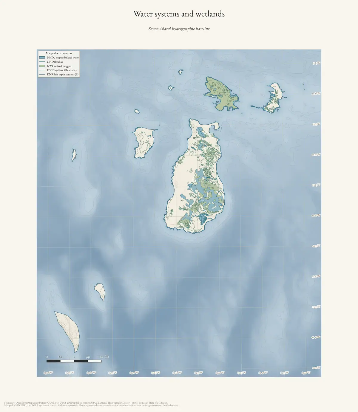
The result is a map-ready place index without pretending that every named place has a surveyed boundary. A polygon record can be compared to SSURGO, NWI, Quaternary geology, circa-1800 cover, and bedrock layers. A point-only bay, stream, reef, or cape remains a name-and-location anchor, with nearest-island proximity rather than an invented area or habitat polygon.
Exact named polygon connections
The largest and most useful polygon records are:
| Named feature | Working area (km²) | Map-context signals |
|---|---|---|
| Lake Geneserath | 1.992681 | SSURGO water with Alpena/Kiva/East Lake, Roscommon, and Belding-Breckenridge margins; NWI lake, forested/shrub, emergent, and riverine classes; lacustrine sand/gravel and dune sand; circa-1800 lake/river, beech–sugar maple–hemlock, and black-ash swamp |
| Font Lake | 1.485209 | SSURGO water with Lupton-Cathro and Tawas-Carbondale margins; NWI lake and emergent/pond/forested classes; dune sand and lacustrine sand/gravel; circa-1800 lake/river, beech–sugar maple–hemlock, mixed-conifer swamp, and shrub swamp/emergent marsh |
| Barney’s Lake | 0.131457 | SSURGO water with Deer Park–Dune and Kalkaska–Leelanau margins; NWI lake classes; dune sand and lacustrine sand/gravel; circa-1800 lake/river with a beech–sugar maple–hemlock margin |
| Fox Lake | 0.303389 | SSURGO water with Kalkaska–Leelanau, Alpena/Kiva/East Lake, Greenwood peat, and Carbondale muck margins; NWI lake and forested/shrub classes; coarse-textured glacial till; circa-1800 lake/river, beech–sugar maple–hemlock, and mixed-conifer swamp |
| Greene’s Lake | 0.240382 | SSURGO water with Greenwood peat and Kalkaska–Leelanau margins; NWI lake, forested/shrub, and emergent classes; coarse-textured glacial till and lacustrine sand/gravel; circa-1800 lake/river and shrub swamp/emergent marsh |
| Egg Lake | 0.083664 | SSURGO water with Tawas-Carbondale and Carbondale muck; NWI freshwater pond, emergent, and forested/shrub classes; lacustrine sand/gravel; circa-1800 lake/river, mixed-conifer swamp, and beech–sugar maple–hemlock |
| Miller’s Marsh | 0.026979 | SSURGO water, Greenwood peat, and Emmet–Leelanau; NWI emergent wetland; lacustrine sand/gravel; circa-1800 lake/river and mixed-conifer swamp |
| Green Swamp | 0.058639 | SSURGO Tawas-Carbondale and water; NWI emergent and pond classes; dune sand and lacustrine sand/gravel; circa-1800 lake/river |
| Swenney Swamp | 0.013685 | SSURGO water and Deer Park–Dune margins; NWI freshwater pond; dune sand; circa-1800 lake/river and beech–sugar maple–hemlock |
| Round Lake | 0.039251 | SSURGO water; NWI freshwater emergent wetland; lacustrine sand/gravel; circa-1800 lake/river |
| Lake Maria | 0.038776 | High Island; SSURGO water and Kalkaska–Leelanau; NWI freshwater pond and forested/shrub wetland; lacustrine sand/gravel and dune sand; circa-1800 lake/river and spruce–fir–cedar forest |
| Beaver Island Public Beach | 0.053461 | SSURGO Deer Park–Dune and Lake beaches; NWI lake; dune sand; circa-1800 beech–sugar maple–hemlock context |
| Jewell Gillespie Park Beach | 0.002682 | SSURGO Lake beaches; NWI lake; dune sand; small circa-1800 forest overlap |
These are overlay summaries, not statements that a lake or marsh has a single uniform soil or vegetation type. Most polygons include water plus shoreline slivers, which is why map-unit and circa-1800 categories appear together.
Point-only named anchors
The exact OSM/GNIS point records preserve a useful coastal and fisheries network, including Baltimore Bay, Bomways Bay, Cable Bay, Donegal Bay, Fisherman Bay, French Bay, Garden Island Harbor, Greenes Bay, High Island Bay, Indian Harbor, Iron Ore Bay, Jensen Harbor, Larsen Harbor, McCauley Bay, Monatou Bay, Ninneegoes Bay, Northcut Bay, Saint James Harbor, Sand Bay, and Sturgeon Bay. They also include named capes such as Conns, Grahams, Indian, and Kelly Points. Because these records are points rather than held polygons, the crosswalk gives their GNIS identity and nearest-island distance but does not assign soil, wetland, geology, or habitat area.
GNIS-only anchors add names absent from the exact OSM match set, including Iron Ore Creek, Jordan River, Little Sand Bay, Gull Island Reef, Richards Reef, Trout Island Shoal, and several islands and capes. The existing KB place articles preserve the source-bounded fisheries, bird, navigation, or historical context for several of these names. “GNIS-only” means only that an exact OSM geometry was not held; it does not mean the feature is unverified or unimportant.
Connecting named places to the ecology corpus
This index makes several existing connections more explicit:
- Font, Fox, Greene’s, Egg, Geneserath, and Barney’s Lakes can be compared with MNFI lake, bog, fen, swamp, loon, fish, and forest observations without treating the OSM water boundary as an MNFI occurrence boundary.
- Miller’s Marsh, Green Swamp, and Swenney Swamp now have a shared map frame for comparing plan descriptions, wetlands, hydric/organic soil vocabulary, circa-1800 cover, and current NWI classes.
- Lake Maria provides a named High Island water anchor for the woodcock and natural-community work, while the crosswalk keeps the lake geometry separate from habitat claims.
- Iron Ore Creek and Jordan River remain GNIS point anchors, preserving the need for stream-specific channel and fisheries geometry rather than assigning them the nearest lake or wetland polygon.
- Beaches and bays such as Donegal Bay, McCauley Bay, Iron Ore Bay, and Beaver Island Public Beach can be connected to the Piping Plover, GLO fishery, mapped-dune, and shoreline records through names and points without fabricating nest or habitat boundaries.
Evidence limits
OSM and GNIS are different sources with different geometry and date semantics.
An exact name match does not prove identical extents. Nearest-island distance is
reported for orientation only; it is not a located_in assertion for a bay,
reef, or offshore point. Polygon overlays use EPSG:6933 calculations against
regional layers and should not be read as legal wetland delineations, parcel
soil determinations, exposed-bedrock observations, or historical continuity.
The crosswalk does not infer wildlife occupancy or convert a planning narrative
into a current condition assessment.
See also
- Wetlands, inland waters, and hydrology
- Geology and landforms
- Forest types and tree history
- Wildlife and bird life
- Soil survey of Charlevoix County, Michigan, 1974
- Archipelago physical geology and hydrogeologic context crosswalk, 2026
- MNFI soil, vegetation, tree, and wildlife crosswalk, 2017
- Lake Geneserath
- Font Lake
- Egg Lake
- Green Swamp
- Miller’s Marsh
- Iron Ore Creek
Sources
- Project-generated named aquatic and wetland place crosswalk.Preserves exact OSM named-feature geometries, exact-name GNIS matches, KB place links, nearest-island proximity, polygon-only SSURGO/NWI/geology/circa-1800 context, and GNIS-only point anchors. No public copy of this file is known; the archive holds one and can provide it on request.research · places · named_aquatic_wetland_place_crosswalk
- Project build script for the named aquatic/wetland place crosswalk.Reproduces the name matching and polygon intersections without inventing geometry around point-only place names. No public copy of this file is known; the archive holds one and can provide it on request.scripts · build_named_aquatic_wetland_place_crosswalk
- Supplies the named polygon and point geometries used as the working place layer; OSM is not a legal or authoritative hydrography boundary source.osm · natural
- Supplies feature names, classes, map names, identifiers, and point coordinates. GNIS points are retained as anchors when no exact OSM geometry is held.federal · gnis · gnis_names
- Used only for polygon intersection context; map-unit overlap is not a parcel soil determination.soils · ssurgo_mapunit_polygons
- Used for modern wetland/deepwater context; the snapshot is not a legal delineation or field survey.federal · layers · nwi_wetlands
- The crosswalk also records context from data/state/michigan/land_cover_circa_1800.geojson and data/geology/vector/mi_bedrock_geology.geojson; all are regional or reconstructed layers with source-specific limits.geology · vector · mi_quaternary_geology
Added 3 August 2026. Recent changes
Cite this article
Beaver Island Archive, “Named aquatic and wetland places crosswalk, 2026”, https://beaverislandarchive.org/documents/named-aquatic-wetland-place-crosswalk-2026/, accessed [date], citing Project-generated named aquatic and wetland place crosswalk. (and 6 further sources listed on the page).
Last revised 2026-08-03. Fill in [date] with the date you read it — this page is static and cannot know that.
BibTeX for “Named aquatic and wetland places crosswalk, 2026”RIS for “Named aquatic and wetland places crosswalk, 2026”