

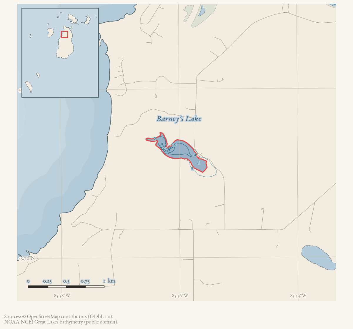
- Coordinates
- 45.7123° N, 85.5594° WGoogle Maps: Barney’s LakeDownload KML
- Eras
- Modern era
- Concepts
- toponymyfishingenvironmentconservationgeologysoilshydrologywetlandsforestswildlifeanimalsbirds
- Within
- Beaver Island
- Media
- Beaver Island History Map, 1978 revision · Plat of Big Beaver Island, 1901 · Plat of the north end of Beaver Island, 1930s
Summary
Barneys Lake is a named inland lake in the north-central interior of Beaver Island, about 2.4 km southwest of Font Lake. GNIS records its official form as “Barneys Lake” and “Barney Lake” as a spelling variant of the same name, not a superseded former name, and attributes the name to Barney O’Donnell, an early settler said to have owned the surrounding land. Helen Collar’s notes independently identify “Barney of Barney’s Lake”, place the original O’Donnell farm there, and transcribe an 1873 federal land entry on the north shore. No dated naming act has been found, but the attribution no longer rests on GNIS alone. Most of the lake and its shoreline are now held by Little Traverse Conservancy as the Barney’s Lake Nature Preserve.
History
The 1978 Historical Map also says the lake was called Long Lake in Mormon
times.1 That alias remains map-only in the sources checked. Farmer’s 1853 map
labels Font and Gennesareth Lakes but does not label Barney’s Lake as Long Lake,
and no held Strang-era newspaper or gazetteer passage located in this audit
supplies the name. It is retained as a research claim rather than added to
former_names.
The earliest held record of organized attention to the lake is a July 1960 notice that state Institute for Fisheries Research staff were collecting fish and food samples from Lakes Geneserath, Fox, “Barncoys,” and Font as part of a Department of Conservation lake-improvement program — the OCR’s “Barncoys” is a garbled rendering of Barney’s, and the survey was a state project independent of Central Michigan University.2 In 1971 a student at the CMU Biological Station, Bill Kuhn, separately asked anglers at Barney’s Lake to record the fish they caught for his own independent study.3 State regulation reached the lake again in January 1975, when it was listed among Charlevoix County waters exempted from the northern pike size limit.4
After the 1963 deer season, Frank Neer and Frank O’Donnell found deer that had broken through the lake ice; volunteers organized a rescue with planks and rope, but the two deer they found had already drowned, while tracks suggested two others had escaped.5 Two decades later, on July 4, 1983, the abandoned O’Donnell House at the lake, described by the Beacon as “one of the largest” houses on the island and a longtime landmark that had sheltered wildlife since its abandonment, burned down; islander Francis LaFreniere recalled visiting to make horseradish the O’Donnells grew there. A separate grass fire near the lake the next day was unrelated.6
An April 1987 Beacon article on loon protection named Barney’s one of five island lakes with historically documented loon nesting, along with Egg, Font, Fox, and Green’s, and singled out Barney’s and Font for the highest nesting success, while noting both lakes’ nest sites were unprotected from boaters.7
Conservation ownership followed. A July 1989 Beacon article reports “Barney O’Donnell’s Farm and SE Portion of Barney’s Lake Deeded to Little Traverse Conservancy,” with public-access and conservation restrictions, and recounts the O’Donnell family’s history at the site.8 A dedication on July 21, 1990 launched a new Conservancy program to protect Beaver Island natural areas, describing the preserve as donated by the O’Donnell family; CMU graduate student Elizabeth Rosenow led a field trip on the day’s natural features.9 The Conservancy’s current website instead dates the original donation to 1988, with further land added in 2007, 2014, and 2025; this article does not reconcile the one-year discrepancy between the contemporary Beacon account and the Conservancy’s later retrospective.10 In 1992 the Conservancy led a day-long ecology program for Beaver Island elementary students at the preserve.
Geography
Barneys Lake sits in Beaver Island’s northern interior, 2.4 km southwest of Font Lake and 4.8 km southwest of Saint James. Two unreconciled figures exist for its size: the 2023 Master Plan gives about 45 acres,11 while an independently computed polygon overlay of the current OSM lake feature measures 0.131457 km2 (about 32.5 acres) in EPSG:6933.12 The Master Plan calls the lake “highly eutrophic,” with a limited yellow perch and rock bass fishery, past stocking of largemouth and smallmouth bass, and continuing habitat for bass, northern pike, and sunfish; a low-impact Conservancy launch sits on the southeastern shore.11 Most of the lake is owned by Little Traverse Conservancy, with a small southern portion under other ownership.11
A 1999 Michigan Natural Features Inventory survey recorded loons at the lake (one pair in May, five individuals in June) among four inland lakes visited that year, alongside Font, Fox, and Lake Geneserath, a sampling rather than a complete census.13 Soil, wetland, and vegetation overlays place it among Deer Park–Dune and Kalkaska–Leelanau soil units and a reconstructed beech–sugar maple–hemlock forest margin: regional map context, not parcel-level fact.12
Names
GNIS carries two forms for feature 620628: “Barneys Lake,” the official name entered through the USGS’s 1976-1981 Geographic Names Phase I compilation, and “Barney Lake,” recorded as a variant of the same name rather than a name it replaced.14 That distinction matters: “Barney Lake” is a variant spelling still in current use, not a name the lake once bore and later lost; checked against the held GNIS variant-names table, “Barney Lake” is correctly classified as a variant, and no former name was found for this feature.15
GNIS’s feature-description record further attributes the name to “Barney O’Donnell, early settler and owner of the land around the lake.”16 Collar’s biographical file supplies an independent identity bridge and a transcribed 1873 north-shore land record.17 What the Beacon establishes, across 1963, 1983, and 1989 reporting, is an O’Donnell family farm and house at the lake for at least a quarter-century, ending in a 1989 conservation gift described in the newspaper as “Barney O’Donnell’s Farm.”568 That is consistent with the naming claim, although neither the compilation nor the newspaper supplies the original naming act.
Evidence and limits
The naming attribution is supported by GNIS and Collar’s biographical and land notes, but the underlying patent and a dated naming act have not been checked. The lake’s acreage is reported differently by two held sources and not reconciled. The 1988-versus-1989 date for the Conservancy’s original land gift is likewise not reconciled between a contemporary newspaper account and the Conservancy’s later retrospective description.
Significance
Barneys Lake recurs across six decades of the Beacon as a working part of island life — a state fisheries survey, licensed pike fishing, a wildlife rescue, a family farm and its loss by fire, and, from the late 1980s, an organized conservation preserve with public access and a documented loon population. It is one of two island lakes (with Font) singled out in 1987 for the archipelago’s highest recorded loon-nesting success.
Open questions
- Can the GNIS Barney O’Donnell naming note be checked against land records or the Journal of Beaver Island History?
- Can any 1847–1856 map, deed, newspaper, or letter identify this lake as Long Lake?
- Does the “Barney O’Donnell” named by GNIS connect genealogically to the Frank O’Donnell recorded at the lake in 1963, and to the farm deeded to Little Traverse Conservancy in 1989?
- Which acreage figure is correct, the Master Plan’s approximately 45 acres or the independently computed 0.131457 km2 (about 32.5 acres) polygon measurement, and what accounts for the difference?
- Did the Conservancy’s land gift occur in 1988, as its current website states, or in 1989, as the contemporary Beacon reports?
- What water-quality or fisheries monitoring supports the Master Plan’s eutrophic classification?
See also
Footnotes
-
Beaver Island Historical Society, Beaver Island History Map, 1978 revision. ↩
-
Beaver Beacon, July 1960, ornithology and fisheries field notes. ↩
-
Beaver Beacon, June 1971, “Central Michigan University News.” ↩
-
Beaver Beacon, January 1975, “Waters Where Northern Pike May Be Taken At Any Size.” ↩
-
Beaver Beacon, December 1963, “Red Coat Invasion Over.” ↩ ↩2
-
Beaver Beacon, April 1987, “Loon Facts.” ↩
-
Beaver Beacon, July 28, 1989, “Barney O’Donnell’s Farm and SE Portion of Barney’s Lake Deeded to Little Traverse Conservancy.” ↩ ↩2
-
Beaver Beacon, August 29, 1990, “Nature Preserve Dedication on Beaver Island to Launch New Conservancy Program.” ↩
-
Little Traverse Conservancy, “Barney’s Lake Nature Preserve,” retrieved 2026-08-02. ↩
-
Project-generated named aquatic and wetland place crosswalk (2026),
data/research/places/named_aquatic_wetland_place_crosswalk.json. ↩ ↩2 -
MNFI, Biological Inventory For Conservation of Great Lakes Islands: 1999 Progress Report (Report 2000-11). ↩
-
U.S. Geological Survey, Geographic Names Information System, Domestic Names (Michigan), retrieved 2026-07-28. ↩
-
USGS GNIS, All Names (national), retrieved 2026-07-28. ↩
-
USGS GNIS, Feature Descriptions (T121), retrieved 2026-07-28. ↩
-
Helen Collar Papers, “Bernard ‘Barney’/‘Barney of Barney’s Lake’ O’Donnell,” Biographical Papers N-S, Clarke Historical Library. ↩
Maps for this place
These Atlas plates provide regional context. They do not establish a precise boundary, current ownership, access right, operating status, or field condition.
- EnvironmentSoils, wetlands, hydrography, and terrain
- GeologyGeneralized geology and landforms
- HydrologyMapped water and wetland context
- AccessMapped routes, facilities, and protected areas
- Land surveyPLSS geometry and historic GLO patent-location context
The dated record
Sources
- GNIS feature 620628; feature class 'Lake'; official name 'Barneys Lake'.federal · gnis · gnis_names
- Feature 620628 description names Barney O'Donnell as an early settler and owner of land around the lake, and locates it 2.4 km SSW of Font Lake and 4.8 km SW of Saint James.federal · gnis · gnis_feature_descriptions
- Feature 620628 carries one variant row, 'Barney Lake' (feature_name_official = Variant), against the official 'Barneys Lake' (feature_name_official = Official, from the USGS Phase I compilation, 1981). A spelling variant of the same name, not a different name -- classified here as alt_names, not former_names.federal · gnis · gnis_variant_names
- Describes Barney's Lake as about 45 acres, a 'premier fishing location' primarily owned by Little Traverse Conservancy except for a small southern portion, stocked in the past with largemouth and smallmouth bass, and with a low-impact public launch on the southeastern shore. Elsewhere in the same document describes the lake as 'highly eutrophic' with a limited yellow perch and rock bass fishery.
- MNFI, Biological Inventory For Conservation of Great Lakes Islands: 1999 Progress Report (Report 2000-11), Common Loon and Beaver aquatic-site crosswalk records.Described in this archive: MNFI Great Lakes Islands 1999 progress report crosswalk.Records one Common Loon pair at Barney's Lake in May and five individuals in June, and lists Barney's among four inland lakes visited in the aquatic work. These are dated observations, not a complete loon census or lake inventory. No public copy of this file is known; the archive holds one and can provide it on request.research · wildlife · indices · mnfi_great_lakes_islands_1999_inventory_index
- Project-generated named aquatic and wetland place crosswalk (2026).Described in this archive: Named aquatic and wetland places crosswalk, 2026.Provides polygon overlay context for the named lake; measures the OSM-digitized polygon at 0.131457 km2 (about 32.5 acres) in EPSG:6933, appreciably smaller than the Master Plan's approximately 45 acres. SSURGO, NWI, geology, and circa-1800 categories are regional/map context, not parcel soil determinations or current habitat boundaries. No public copy of this file is known; the archive holds one and can provide it on request.research · places · named_aquatic_wetland_place_crosswalk
- Reports Mr. Rodeheffer and Mr. Day of the state Institute for Fisheries Research collecting fish and food samples from Lakes Geneserath, Fox, 'Barncoys' [Barney's], and Font as part of a Michigan Department of Conservation lake-improvement program -- an independent state survey, not a Central Michigan University project.data1 · beaver-island-archive · beaver_beacon · 1960-07_Beaver-Beacon
- Confirms the report.data1 · beaver-island-archive · scans · beaver_beacon · issues · 1960-07_Beaver-Beacon
- Reports that Bill Kuhn, a Central Michigan University Biological Station student, asked anyone fishing at Barney's Lake to record the kind, weight, and length of fish caught for his independent study.data1 · beaver-island-archive · beaver_beacon · 1971-06_Beaver-Beacon
- Reports Frank Neer and Frank O'Donnell finding deer that had broken through the ice at Barney's Lake after the 1963 season; volunteers organized a rescue with planks and rope, but the two deer described had already drowned, while tracks suggested two others escaped.data1 · beaver-island-archive · beaver_beacon · 1963-12_Beaver-Beacon
- Confirms the report.data1 · beaver-island-archive · scans · beaver_beacon · issues · 1963-12_Beaver-Beacon
- Reprints a state notice listing Barneys Lake among Charlevoix County waters exempt from the northern pike size limit. The holding institution's portal restricts automated access; the archive holds a copy of this issue and can provide it on request.data1 · beaver-island-archive · beaver_beacon · 1975-01_Beaver-Beacon
- Reports the abandoned O'Donnell House at Barney's Lake, described as 'one of the largest' houses on the island and a longtime landmark, burning on July 4, 1983; recalls the family growing horseradish there; records a July 5 grass fire near the lake, unrelated to the house fire. The holding institution's portal restricts automated access; the archive holds a copy of this issue and can provide it on request.data1 · beaver-island-archive · beaver_beacon · 1983-08_Beaver-Beacon
- Confirms the report.data1 · beaver-island-archive · scans · beaver_beacon · issues · 1983-08_Beaver-Beacon
- States that loons are historically documented to have nested on five island lakes -- Barney's, Egg, Font, Fox, and Green's -- with high nesting success shown on Barney's and Font, both unprotected from boaters at the time. The holding institution's portal restricts automated access; the archive holds a copy of this issue and can provide it on request.data1 · beaver-island-archive · beaver_beacon · 1987-04_Beaver-Beacon
- Confirms the report.data1 · beaver-island-archive · scans · beaver_beacon · issues · 1987-04_Beaver-Beacon
- Reports the deed of Barney O'Donnell's farm and the southeast portion of the lake to Little Traverse Conservancy, with public access and conservation restrictions and a recounting of O'Donnell family history. Independently corroborates the O'Donnell family's ownership at the lake. The holding institution's portal restricts automated access; the archive holds a copy of this issue and can provide it on request.data1 · beaver-island-archive · beaver_beacon · 1989-07_Beaver-Beacon
- Reports a July 21, 1990 dedication of the Barney Lake preserve, describing it as donated by the O'Donnell family, with a field trip led by CMU graduate student Elizabeth Rosenow. The Little Traverse Conservancy's current website separately dates the original donation to 1988; this article does not reconcile the two dates. The holding institution's portal restricts automated access; the archive holds a copy of this issue and can provide it on request.data1 · beaver-island-archive · beaver_beacon · 1990-08_Beaver-Beacon
- Describes a 363-acre preserve with frontage on both Barney's Lake and Lake Michigan, an old farmstead, and trails; dates the original land donation to 1988, with later additions in 2007, 2014, and 2025.
- Identifies the original O’Donnell farm of Barney and his half-brother at the lake and transcribes an April 1873 federal transfer to Bernard O’Donnell of land on its north shore. This supports the GNIS namesake attribution, while remaining a research compilation rather than the underlying patent.web · collar_biographical_biographical-papers-n-s
- Described in this archive: Beaver Island History Map, 1978 revision.Attributes the current name to Barney O’Donnell and calls the lake “Long Lake in Mormon times.” The first clause is independently corroborated; no Strang-era source located calls this lake Long Lake.
Added 28 July 2026 · revised 7 August 2026. Recent changes
Cite this article
Beaver Island Archive, “Barney’s Lake”, https://beaverislandarchive.org/places/barneys-lake/, accessed [date], citing U.S. Geological Survey, Geographic Names Information System, Domestic Names (Michigan), retrieved 2026-07-28. (and 20 further sources listed on the page).
Last revised 2026-08-07. Fill in [date] with the date you read it — this page is static and cannot know that.