

- Coordinates
- 45.6382° N, 85.5787° WGoogle Maps: Greene’s Lake TrailDownload KML
- Eras
- Modern era
- Concepts
- trailstransportationrecreationModern eratoponymy
- Within
- Beaver Island
Summary
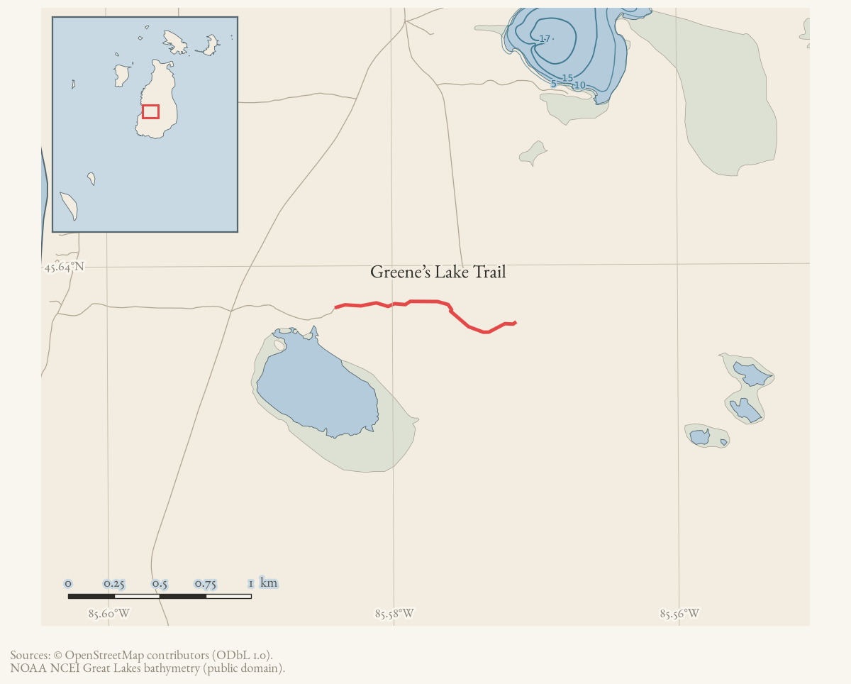
Greene’s Lake Trail is a trail name on the 2015 map and in the 2016 DNR trail report. Current OSM linework is named Greene’s Lake Road. This page shows that line only as an approximate, source-qualified proxy until the trail and road names can be reconciled.
Official map: Greene’s Lake / Johnny Martin’s Trail (BITA, July 2019).
What the trail sheets show
Peaine Township’s own narrative guide and the Beaver Island Trail Association’s July 2019 sheet describe different things under overlapping names.
The township’s 2021 guide treats “Greene’s Lake Road” as a short spur: “This may be accessed from West Side Drive or from Camp #3 Trail. It is 0.25 mile to Green’s Lake itself from West Side Drive, then another 0.78 mile east to the junction with Camp #3 Trail (total 1.03 miles). It is generally driveable.” The same guide describes Camp #3 Trail, Government Tower Trail and Middie Perron’s Trail as distinct routes.
The BITA sheet instead composites several of those routes under one name: “The Greene’s Lake Trail, also called Johnny Martin’s Trail, starts at East Side Drive about a mile South of Wagner Campground. It continues through Government Tower Trail, crossing Camp 3 Trail, and continues onto the Greene’s Lake Trail, which passes Greene’s Lake and ends at West Side Drive,” for a stated total of 5.5 miles. On the BITA sheet’s own account this “Greene’s Lake Trail” runs the course of Middie Perron’s and Government Tower before it ever reaches the lake — a composite route sharing a name with, and possibly identical in part to, Johnny Martin’s Trail.
This article does not resolve the conflict, following
docs/trail-articles.md. The short lake-access spur the township calls
Greene’s Lake Road is the route this article’s geometry approximates; the
longer composite route the BITA sheet calls by the same name is an open
question below.
Access and ownership
The 2024 Peaine Township Parks and Recreation Plan’s asset table lists “Greene’s Lake Public Access” as Michigan DNR land leased to Peaine Township (“MDNR leased by PT”), for fishing — the access point at the West Side Drive end of the road/trail this article covers. The same plan’s goals section lists “increase and improve accessibility at Greene Lake Park” among its 2024–2028 waterfront objectives.
The Beaver Island Trail Association’s Greene’s/Martin’s sheet, which covers the longer composite route, states “This is a wilderness area. You may encounter impassable wet areas due to seasonal conditions,” and carries the association’s standard disclaimer that its maps are not official DNR maps and should not be relied on for complete accuracy, current as of July 2019.
There are no designated public ORV trails on Beaver Island (see Trails and trail-making).
As walked in 2019. a walked account contributed in 2019 reaches this trail from the east, by Johnny Martin’s Trail, and recommends against it: beyond a small meadow with a large culvert the tread is overgrown and uneven, was still damp in late August, and carries downed trees, so ‘it may be better to access the Green’s Lake Trail from the western end if that is an important part of the hike.’ The spelling is the author’s.
Evidence and limits
This trail is published — in the 2015 map, the 2016 DNR trail report and
the 2021 township guide — though, as above, the two most detailed sources
describe different lengths of route under the name. It is mapped only
approximately: current OpenStreetMap carries “Greene’s Lake Road,” not a
feature explicitly named “Greene’s Lake Trail,” so the geometry shown here is
a proxy and geometry_status is approximate. No GPS track or LiDAR search
held here is tagged to this route, so it is neither walked nor
searched in the archive’s sense.
Open questions
- Is the Beaver Island Trail Association’s “Greene’s Lake Trail” (5.5 miles, composited from Middie Perron’s/Government Tower’s route through Camp #3 to the lake) the same route the township guide calls “Greene’s Lake Road” (1.03 miles, a short spur), or is the BITA name better understood as another name for Johnny Martin’s Trail?
- Does current OpenStreetMap’s “Greene’s Lake Road” correspond to the township’s short spur, to part of the BITA composite route, or to neither?
- Has anyone walked this route, in either sense, with a GPS? No track held here is tagged to it.
If you can answer any of these, or correct anything above, the archive wants to hear it — see Corrections.
Map status
The map uses a simplified OSM Greene’s Lake Road line retrieved 2026-08-02; it is not evidence that every road segment is hiking trail. Pending update: compare the line with the Peaine trail-description packet or a field GPS track and replace the proxy with a confirmed route (or mark unresolved).
Documented associations
No source-confirmed non-road entity is linked yet. Exact-name research leads remain in scripts/audit_road_links.py; a name collision is not treated as a road association.
Research status
The local newspaper and website corpus contains exact-name mentions in 0 file(s). Those files are research leads; the relation layer is added only when the surrounding source text establishes that the record involves this road.
Maps for this place
These Atlas plates provide regional context. They do not establish a precise boundary, current ownership, access right, operating status, or field condition.
- EnvironmentSoils, wetlands, hydrography, and terrain
- GeologyGeneralized geology and landforms
- HydrologyMapped water and wetland context
- AccessMapped routes, facilities, and protected areas
- Land surveyPLSS geometry and historic GLO patent-location context
Sources
- The legend prints Greene’s Lake Trail.
- Names Greene’s Lake Trail among the maintained trail routes.
- OSM currently maps Greene’s Lake Road, not a feature explicitly named Greene’s Lake Trail; the displayed line is therefore approximate.osm · trails
- Printed page 17 describes Greene's Lake Road as a 1.03-mile spur from West Side Drive to a junction with Camp #3 Trail, distinct from Middie Perron's, Government Tower and Camp #3 trails described in the same guide.governance · peaine · trails · all-trail-descriptions
- States 'The Greene's Lake Trail, also called Johnny Martin's Trail, starts at East Side Drive...continues through Government Tower Trail, crossing Camp 3 Trail, and continues onto the Greene's Lake Trail...' for a stated 5.5 miles -- a composite route under the same name as the township's shorter Greene's Lake Road.governance · peaine · trails · bita-greenes-martin-trail-2019-07
- Table 3.1 lists Greene's Lake Public Access as MDNR land leased to Peaine Township, for fishing; Goal 7 lists improving accessibility at Greene Lake Park among the 2024-2028 waterfront objectives.governance · peaine · trails · peaine-park-and-rec-plan-draft-2023-11-27
- Kamrin, Michael. 'An Insiders Guide to Beaver Island Hiking Trails: A Companion to the Wojan/Cashman Beaver Island Map.' Unpublished typescript, created 8 August 2019, last revised 17 February 2020.Walked account, treating Greene's Lake and Johnny Martin's as one route from the East Side Drive end. Records the eastern approach as overgrown and uneven beyond a small meadow with a large culvert, still damp in late August, with downed trees across it, and advises reaching this trail from its WESTERN end instead. About 2.7 miles from the trailhead to Middie Perron's Trail. Blaze: red paint on trees.fieldwork · accounts · kamrin-insiders-guide-bi-hiking-trails
Added 2 August 2026. Recent changes
Cite this article
Beaver Island Archive, “Greene’s Lake Trail”, https://beaverislandarchive.org/places/greenes-lake-trail/, accessed [date], citing Beaver Island trails map, revised October 2015. (and 6 further sources listed on the page).
Last revised 2026-08-02. Fill in [date] with the date you read it — this page is static and cannot know that.
BibTeX for “Greene’s Lake Trail”RIS for “Greene’s Lake Trail”