

- Eras
- Modern era
- Concepts
- trailsrecreationtransportationtourismgovernancebirdsModern era
- Within
- Beaver Island
- Media
- The Beaver Island Trail Map kiosk at the Y, 2026
Summary
Beaver Island has somewhere between twenty-four and thirty-five named trails. The count depends on which document you read, and the archive cannot make the lists agree.
There is a plain reason for that. Someone prints a route on a map. Someone else walks it. Someone else cuts the fallen trees out of it. They are rarely the same person, and rarely in the same year.
This page gathers what the archive holds: the routes themselves, the four systems they fall into, the groups who cut and clear them, and the kinds of evidence that put a line on a map.
What counts as a trail here
The clearest statement about island trails comes from the people who maintain them. The Beaver Island Archipelago Trails Association wrote this in its 2021 draft master plan:
Most of what are considered “trails” on the island are actually Charlevoix County roads or old two-track logging trails originally created by the DNR, which have little connectivity, few destination points, and are somewhat dangerous given they are not level or maintained to public trail standards.
So nearly every named trail here is also something else. It may be a county road, a lumber railroad grade, a fire line the state cut in the 1940s and 1950s, or a wagon track between farms. Kuebler Trail runs on the last intact grade of the Beaver Island Lumber Company’s narrow-gauge railroad. Trail Road (historic) is a road named for having once been a trail.
The same plan notes a gap. Apart from the short paved path on Donegal Bay Road, the island has no route built for leisure cycling or mountain biking.
An article about a trail is usually also an article about lumbering, land survey, or the county road system. It should say so. See Lumbering.
The four kinds of evidence
The archive holds four separate kinds of knowledge about where a trail goes. They do not agree. Keeping them apart is the first thing to get right.
| Evidence | What it means | What the archive holds |
|---|---|---|
| Printed | A township, association or guide printed a sheet for it | Peaine’s trail document centre, the BITA sheets of July 2019, visitor guides |
| Mapped | A line exists | 139 OpenStreetMap ways under 32 names |
| Walked | Someone walked it with a GPS at walking pace | Five field tracks, 2024 and 2025, south end only |
| Searched | Someone walked slowly and found no path | Five recorded runs |
The Blue Trail is printed and unmapped. The township prints a cue sheet for it, and OpenStreetMap has no line for it at all. Twelve walked runs, 6.55 km together, are on the ground and missing from the map. A lidar survey was meant to find old trails from the shape of the bare earth. It found five of those twelve. So a blank in the relief is not proof that no trail is there, and no article here may treat it as one.
The archive draws this rather than settling it. The island plate keeps the four kinds apart, over the 2018 lidar image of the bare ground, which shows old grades the modern map leaves out.
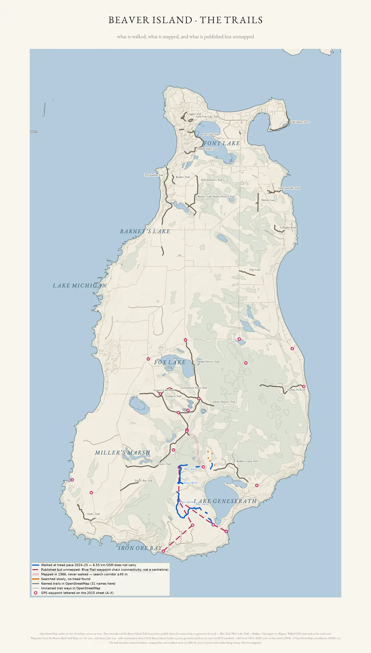
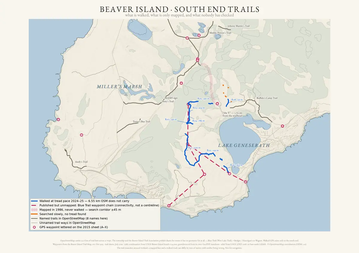
There is a fifth thing, which the table above does not have a row for because until 2026 the archive had almost none of it: someone walked it and wrote it down, without an instrument. A guide to ten south-end trails, written in 2019 and contributed to this archive by its author, gives turn-by-turn directions, trailhead access, parking and estimated distances — see An Insiders Guide to Beaver Island Hiking Trails, 2019.
That is kept apart from the walked row on purpose. A GPS track is a line and can be argued with; a walked description tells you whether a turn is findable and whether the tread is wet in August, and supplies no geometry at all. Both are first-hand. Only one of them can be put on a map.
Each article says which evidence it rests on. The rules are in
docs/trail-articles.md.
Peaine Township’s trail-map library
These are the current public originals, linked directly from Peaine Township rather than to the archive’s research copies. A sheet records what its publisher represented at its date; it is not a promise that a route is open, passable, or accurately surveyed today. The route pages below identify the particular sheets that bear on them.
The four systems
Walking and hiking trails
The oldest system, and the least formal. Its named routes are listed below. The work runs from the Beaver Island Game Club, which cut and marked hunter trails in the late 1950s, through a Peaine Township trails committee, to the present association. Much of the network has been cleared, lost to windfall, and cleared again.
The Beaver Island Water Trail
A 42-mile (68 km) paddling route around the island, closed to motors. Work began in 2016 with the Michigan DNR and the Little Traverse Bay Bands of Odawa Indians. The Land Information Access Association planned it under Coastal Zone Management funding. It was dedicated on 1 September 2018.
Nine of its access sites sit on state land. Those needed a Land Use Order from the Natural Resources Commission, granted in October 2017 after tribal historic-preservation review.
Two lengths circulate. The Development Plan says 42 miles. The 2023 master plan and the Associated Press story say 43. That master plan also dates the dedication to 2016, which the record from the time contradicts. Use the plan’s own figure and the 2018 date, and say why.
The Beaver Island Birding Trail
Not a cut trail. It is a set of existing public viewing sites, modelled on the Sleeping Bear Birding Trail and dedicated in May 2014. Always date the stop count: thirty-three sites were planned in 2013, the 2017 master plan says thirty-four, and the 2024 recreation plan and the guide say thirty-five. It carries the yearly Warblers on the Water weekend. See Wildlife and bird life.
Motorized routes
Beaver Island has no designated public ORV trails. Public Act 288 of 2016 opened state forest roads to off-road vehicles unless they are posted closed, and the DNR mapped those roads here in April 2019. Forest roads are not trails, and that difference is the substance of a long island argument. Snowmobiles use the same network in winter, and the record shows snowmobilers cutting deadfall that walkers later benefit from.
How the trails are marked
There are no trail signs to speak of on this island, and the guides say so. What there is instead is paint and plastic diamonds on trees. The key below is recorded in one source only, a guide walked in 2019, and nowhere else in this archive:
| Trail | Marking |
|---|---|
| Blue Trail, North Lake Trail | Blue diamond; older blue paint survives in places |
| Buffalo’s Camp Trail | Blue diamond with a white border |
| Johnny Martin’s Trail, Greene’s Lake Trail | Red paint on trees |
| 7 Bridges Trail | Yellow diamond |
| Camp #3 Trail, Doty’s Camp Trail | Orange diamond |
| The main road around the island | Green diamond on utility poles and trees |
Two things follow. The blue diamond does not identify a trail on its own — the white border is the whole difference between Buffalo’s Camp Trail and the Blue Trail, and a junction tree can carry blue and orange together. And the markings are a volunteer product: the same source records that there is no regular trail maintenance, so a colour is evidence of what somebody last painted, not of who is responsible now.
The same guide ties four trailheads to numbered Beaver Island Birding Trail markers — #15 at the South Fire Station, #16 on Johnny Martin’s Road, #19 at Cable’s Creek and #20 at the North Arm boat launch — which is the only link held between the birding markers and the walking trails. It also records public toilets at three trailheads: Bill Wagner Campground across from Seven Bridges, Lake Geneserath public access near Buffalo’s Camp, and Miller’s Marsh just north of Doty’s Camp.
The named trails
Grouped by where they are. A name in plain text has no article yet.
South end, around Lake Geneserath and the Beaver Head Blue Trail (also the West Lake Trail) · Buffalo’s Camp Trail · Doty’s Camp Trail · North Lake Trail · Camp #3 Trail · Greene’s Lake Trail · Johnny Martin’s Trail · Middie Perron’s Trail · 7 Bridges Trail · Cable's Creek Trail · Government Tower Trail · Buddy's Trail · Betsy Smith Trail
West side and the dunes Mrs Redding Trail · Andy's Trail · French Bay Trail · Katherine's Climb Trail · Young James Trail
North end and the harbour Kuebler Trail · Hidden Valley Trail · Little Font Lake Trail · Little Sand Bay Trail · Mooney's Trail · Fox Pointe Trail · Coggins Trail · Sunset Trail North and South, named by St. James Township in March 2024 and not yet described anywhere
Composite routes named on printed maps The 2015 trails map legend names routes built from several trails and roads rather than single paths: Around the Island · ½ Way Around the Island · Hannigan’s to Wagner Campground.
Named in the sources, not yet articles Teeter’s Bus Trail and Old Lighthouse Road, both listed in a 1995 inventory of the Wojan-Cashman map as it stood in 1990. The Orange Vest (McAndrew) Trail and the Vreeland (Pat’s) Trail, connector spurs off the Blue Trail. South Mill Trail. Softwood Camp Trail, from a 1993 township report. And Hideaway Trail, which the current visitor guide names and no mapped feature matches.
Residential and platted ways carrying trail names Chipmunk Trail · Hemlock Trail · Tamarack Trail · White Cedar Trail · Trail Road (historic)
Outer islands Danes Trail on Garden Island. State plans record trails and trail maintenance as management matters on Garden, North Fox and South Fox islands, and a route runs to the DNR cabins on High Island.
The composite routes need stating plainly, because the printed sheets and the mapped lines name them differently. The July 2019 Blue Trail sheet describes a 7.5-mile loop built from the Blue Trail, Buffalo’s Camp Trail, and East Side Drive with South End Road. A spur links the Blue Trail to Buffalo’s Camp Trail, and carries on north to Doty’s Camp Trail.
What the trails pass
Island trail guides name landmarks in unusual detail. On a network of unsigned two-tracks, the landmark is how you navigate.
The same features keep returning in the printed descriptions. The MASH sign is a four-by-four post at a junction in the south interior, carrying four blue direction signs. A long wooden bridge crosses Gorge Creek on the Blue Trail. “The Y” is a fork marked by a DNR no-ORV sign, where the North Lake Trail leaves Buffalo’s Camp Trail. Doty’s Camp is a deer camp with a stone fire pit and an outhouse. A boardwalk crosses the cedar swamp at Little Sand Bay. Scout troops built and rebuilt the seven bridges that name the Seven Bridges Trail. Government Tower Trail is named for a state fire lookout that no longer stands.
Several trails run past ruins. Mooney’s Trail passes a frame house, a collapsed two-storey log cabin with plaster still on its walls, a smaller cabin turned into a barn, a log-lined well, and 1920s cars rusting in the woods. Danes Trail on Garden Island passes the abandoned Garden Island School, its belfry fallen and school desks still inside, and the ruin of the island’s Catholic church. In 1995 an islander remembered Middie Perron’s Trail for its apple trees, and for a drive-through barn that is now gone. He had ridden through it in a buggy as a child, and called it “the Island’s only covered bridge”.
Natural history along the trails
The trails are how a walker reaches the island’s protected plant communities. Several lead straight to species that state or federal law protects. Those plants are fragile and easy to reach, which is why this belongs on a trail page rather than only in a survey.
The Michigan Natural Features Inventory surveyed seventeen sites on Beaver Island in 2017. Several sit on or at the end of a named trail.
The interdunal wetland at Little Sand Bay holds Michigan monkey-flower (Mimulus michiganensis), endangered in the state and federally, along with butterwort and Lake Huron tansy. The open dunes at Cable Bay and McCauley Point hold Pitcher’s thistle (Cirsium pitcheri), threatened at both levels. At French Bay, dwarf lake iris (Iris lacustris) is a local dominant in the boreal forest. It is Michigan’s state wildflower, and threatened at both levels. Martin’s Bluff carries old-growth sugar maple, hemlock and beech over 250 years old. Doty’s Swamp, north-west of Lake Geneserath, is a rich conifer swamp where a hemlock was cored at 284 years. The township’s own guide describes Andy’s Trail as reaching a shore known for dwarf lake iris.
The Beaver Island Birding Trail chose its stops for habitat, so it doubles as a natural-history index to the network. Seven Bridges Trail runs through a dry mesic northern forest that MNFI treats as threatened. Johnny Martin’s Trail passes an abandoned beaver pond, with kingfishers nesting in the gravel banks. Cable’s Creek Road is known locally as Warbler Alley. Fox Lake holds one of the largest bogs in the state. Miller’s Marsh, managed by the Central Michigan University Biological Station, is listed for the range of its habitats.
Two warnings belong on any page that repeats this material. Michigan law protects native orchids, trilliums and club mosses, and the record includes the removal of two of the largest showy lady’s-slipper clumps from beside King’s Highway. The birding-trail brochure held here is a scan with no text layer, and the automatic reading of it is badly garbled. Read it from the scan. Do not quote the extraction.
See Native and rare plants and Wildlife and bird life.
Who makes and maintains them
No parks department has ever run these trails. A series of volunteer and township bodies has.
- Beaver Island Game Club cut and marked hunter trails through the late 1950s and 1960s. This is the earliest sustained trail programme in the record.
- A Peaine Township trails committee ran through the 1990s and 2000s, with the Chamber helping on mapping and promotion.
- “Top O’ MI Trails” was a short-lived regional effort, recorded in township minutes before the present association formed.
- Beaver Island Archipelago Trails Association was founded in 2017. It is a volunteer body, and it works under yearly DNR special-use permits.
- Scout troops built bridges and boardwalks, repeatedly.
- Little Traverse Conservancy owns and manages several preserves the network reaches.
The state owns much of the ground. See Beaver Islands State Wildlife Research Area and Island civic governance and public institutions.
Access, ownership and conflict
One route can cross state land, county road right-of-way, township property, a conservancy preserve, and private land. The archive holds four disputes about that. A landowner objected in public that publishing a route across his property exposed a five-hundred-member association to liability. Another found people driving down his drive to reach state dune land. Someone blocked a trailhead with rocks and was never identified. Water-trail signs went missing in 2019, which some called vandalism and others put down to un-anchored posts washing away.
None of this is settled. An article that calls a route “open to the public” without a source is making a claim the archive cannot support. That is why every trail page carries an access-and-ownership statement.
Evidence and limits
The archive is strong on what was printed and what was decided in public. It is thin on survey. The township’s current 18-document trail-map library is held, along with two related planning documents; it includes a narrative guide to every named trail and all seven July 2019 BITA sheets. Township and collaborative minutes carry the governance record in detail. Against that, the only instrumented ground truth is five walked GPS tracks at the south end, joined in 2026 by a walked but uninstrumented guide to ten south-end trails, contributed by its author. Nobody has walked the northern two-thirds of the island into this archive by either route.
Three named trails are printed with no mapped line. Hideaway Trail appears in the visitor guide and matches no mapped feature under any name. The July 2019 Camp #3 to French Bay sheet is held, but it is a composite guide that uses several named trails; it does not supply a surveyed line for any of them.
The Wojan-Cashman map
The most widely distributed island map is the Wojan-Cashman map, and a 1995 account credits it with naming twenty-four trails. The archive now holds a copy of the 1977 original, taken from the web version beaverisland.net serves. The fourth edition appeared in 2018 and is sold through the Beaver Island Chamber of Commerce.
Editions matter here. The twenty-four-trail figure describes the map as it stood in 1990. That is neither the 1977 sheet nor the 2018 one, so a trail count must not be carried between them.
What the 1977 sheet settles on its own authority is the grading. Its legend separates seven kinds of route: paved road, gravel road, dirt road, drivable trail, four-wheel-drive trail, walking trail, and faint walking trail. It also shades land public or private, cleared or wooded. A cartographer in 1977 needed four categories between “dirt road” and “faint walking trail”. That is independent support for what the trail association found forty years later, which is that most island trails are roads of one grade or another.
The sheet is copyright 1977 by William J. Cashman and Edward B. Wojan, all rights reserved, and its margin bars whole or partial reproduction by any means. This archive holds it for citation only and does not reproduce it. The publisher serves the full map at beaverisland.net.
Open questions
- Which present-day segments match the Blue Trail’s old route between Oil Well #1 and the Beaver Head light? A walked track of the northern half would settle it. The archive has none north of Lake Geneserath.
- Where is the Hideaway Trail? The visitor guide names it and no mapped feature matches.
- How do the trail lists reconcile? A 1995 account gives twenty-four names for the Wojan-Cashman map as it stood in 1990, OpenStreetMap carries thirty-two, and the current visitor guide lists sixteen.
- Which Wojan-Cashman edition named twenty-four trails? The 1977 original is held and the fourth edition is 2018. The count comes from a 1995 account describing the map “as recently as 1990”, which is neither. A copy of the edition current in 1990 would settle it.
- Was Buffalo’s Camp Trail named for the John Malloy nicknamed “Buffalo” in the genealogy record? No source ties the nickname to the trail.
- Who placed the sign and rocks at the Hidden Valley trailhead in September 2009? The question was asked in public and never answered.
- Which trails were fire lines the state cut in the 1940s and 1950s, as island accounts say? No state document in the archive lists them.
- Where did Teeter’s Bus Trail and Old Lighthouse Road run? A 1995 inventory names both, and they appear nowhere else.
- Is North Lake Trail a branch of Buffalo’s Camp Trail, or another name for it? The township’s guide says the first, the 2019 BITA sheet says the second, and a third account walked in 2019 agrees with the township — a signed divide, the right fork the well-used one running on to Doty’s Camp Trail, the left fork the original trail dead-ending at the Blue Trail. Two independent observers put the Y within a quarter mile of each other. What would settle it is a walked track, which nobody holds.
- Who were Coggins Trail and Katherine’s Climb Trail named for? Neither has any description in the archive. A Coggin family held island property, but no source connects them to the trail.
If you can answer any of these, or correct anything above, the archive wants to hear it — see Corrections.
See also
Sources
- States BIATA's 2017 founding and mission verbatim, and the finding that most routes called trails on the island are county roads or DNR-era logging two-tracks. A stakeholder-review draft, not an adopted plan.
- Gives the trail's length as 42 miles (68 km) and documents the Land Use Order process for the nine state-owned access sites. Funded through the Michigan Coastal Zone Management Program.governance · peaine · trails · bi-water-trail-full-plan
- Names the Blue Trail's alternative name, its start point, its spur to Buffalo's Camp Trail, lettered waypoint distances, and the 7.5-mile loop figure. Carries the disclaimer that BIATA maps are not official DNR maps.governance · peaine · trails · bita-blue-trail-2019-07
- Narrative descriptions of the island's named trails. Undated in the file itself; retrieved from the township document centre in August 2026.governance · peaine · trails · all-trail-descriptions
- Lists the numbered birding-trail stops grouped by region of the island. The stop count differs between this guide and the master plans; see the article body.governance · peaine · trails · bi-birding-trail
- Implements Public Act 288 of 2016 on Beaver Island state forest roads. Concerns forest roads, not designated ORV trails.governance · peaine · trails · beaver-forest-roads-open-to-orvs
- A student capstone report recommending non-motorized designation on some trails. Advisory only; not adopted by either township.governance · peaine · trails · beaver-island-trails-master-plan-msu
- A four-phase consultant work plan for a formal multi-use trail system, naming the DNR, EGLE, SHPO and THPO as technical advisors.governance · township_meetings · st-james-planning · beaver-island-trail-plan-draft-work-plan-20220908-pdf-63151de0ea
- Names hiking trails and trail maintenance among management matters on state land on Beaver, Garden, North Fox and South Fox islands. The michigan.gov copy returns 403 to this project's user agent; the held copy is filed under data/research/.research · island_farming · mdnr_northern_lake_michigan_islands_plan_2017
- 139 ways carrying 32 distinct names. Licensed ODbL 1.0. Community-contributed geometry of unknown survey provenance, not an authoritative trail inventory.osm · trails
- Walked GPS tracks, Beaver Island south end, 2024-2025, M. Bommarito.Five field tracks used as ground truth for the trail review. Two of the 2025 exports are damaged and their timestamps are unusable; see the sidecars.fieldwork · gps_tracks
- Beaver Island trail review package, GPS and LiDAR comparison, 2026.Documents that the LiDAR roughness method recovered only 5 of the 12 GPS-confirmed trail runs, and that a LiDAR miss is therefore not evidence of absence.output · gis · review · README
- The island map a 1995 Beaver Beacon inventory describes as the most widely distributed on the island, naming twenty-four trails as of 1990. Held for research and citation verification only and not republished here; beaverisland.net serves the full version at the linked page. The retained image carries no date of its own, so the 1990 currency is the Beacon's characterisation rather than the map's own statement.maps · cited · www.beaverisland.net · beaverislandnet_bimap
- Kamrin, Michael. 'An Insiders Guide to Beaver Island Hiking Trails: A Companion to the Wojan/Cashman Beaver Island Map.' Unpublished typescript, created 8 August 2019, last revised 17 February 2020.Contributed by the author for publication in this archive. A walked guide to ten south-end trails with trailhead access, parking and estimated distances. Carries the only trail blaze key held here, ties four trailheads to Beaver Island Birding Trail marker numbers, and lists three public toilets by trailhead. Leaves Camp 3 Trail and Doty's Camp Trail undescribed.fieldwork · accounts · kamrin-insiders-guide-bi-hiking-trails
Added 16 August 2026. Recent changes
Cite this article
Beaver Island Archive, “Trails and trail-making”, https://beaverislandarchive.org/themes/trails-and-trail-making/, accessed [date], citing Beaver Island Archipelago Trails Association, 'Proposed Work Plan: Beaver Island Trail Master Plan', draft for stakeholder review, 15 October 2021. (and 13 further sources listed on the page).
BibTeX for “Trails and trail-making”RIS for “Trails and trail-making”