

- Intersects
- Allen's Lakeview Road · Back Highway · Beaver Lodge Drive · Font Lake Road · Font View Court · Forest Avenue · Fraser Court · Gull Island Road · Indian Point Road · Karnes Drive · King's Highway · Leonard Lane + 2 more
- Coordinates
- 45.7478° N, 85.5431° WGoogle Maps: Donegal Bay RoadDownload KML
- Eras
- Modern era
- Concepts
- transportationtoponymy
- Within
- Beaver Island archipelago
Summary
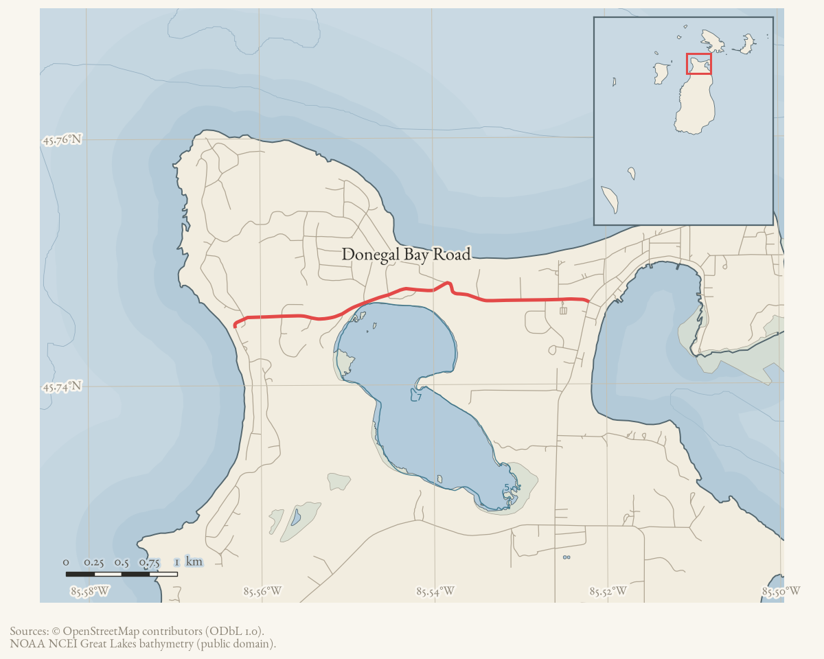
Donegal Bay Road is a named road on Beaver Island’s current OpenStreetMap map.
The two held ways carrying that name are merged here into one route geometry
of about 3.4 km. It meets 14 other named roads, listed under
intersects_road.
Evidence and limits
The name and the alignment are what mappers last entered, and OpenStreetMap is
volunteered work rather than a survey: it settles neither the right-of-way nor
who maintains the road. Where the name came from is a separate question. Plats,
road-commission minutes, and island memory answer that one. Put an older
spelling from any of them into alt_names or former_names, with the source
that attests it.
Open questions
- The January 2024 Donegal Bay Road bike-path extension was reported “awaiting adjustments” as of June 2024 — was the project ultimately built, and on the reported 2025 grading / 2026 paving schedule?
- The 2002 Trail Master Plan proposed a “Donegal Bay Trail” alignment distinct from the road itself — was any part of that proposed trail ever constructed, or does the name survive only as a 2002 planning label?
- The 1993 tennis-court proposal at the Beaver Lodge Drive–Donegal Bay Road corner depended on land donated by R. Neff and W. Webb — were the courts ever built, and are they still in use?
If you can answer any of these, or correct anything above, the archive wants to hear it — see Corrections.
Documented associations
These source-backed records provide context for the mapped route:
- St. James Township Trail Master Plan map, 2002 — This retained St. James Township schematic map labels a Trail Master Plan for Beaver Island. Its legend distinguishes several depicted trail categories from a red “Proposed Donegal Bay Trail Proposed 2002” alignment. The map therefore records a planning proposal and a contemporary way of representing the local trail network; it does not prove a…
- Proposed Beaver Island tennis courts at Beaver Lodge Drive and Donegal Bay Road, 1993 — In April 1993, a Beaver Beacon township report said Boyle & Palladino had sent an $80,000 state grant application for tennis courts. The report placed the proposed site at the Beaver Lodge Drive–Donegal Bay Road corner, with property to be donated by R. Neff and W. Webb and H. Hart identified as project organizer. The report describes a proposal and…
- St. James reports preliminary engineering for Donegal Bay Road bike-path extension, 2024 — In January 2024, St. James Public Works committee action-plan notes reported Township Board approval of a contract to arrange preliminary engineering for a proposed Donegal Bay Road bike-path extension. The notes set out a prospective 2025 grading and 2026 paving sequence. By June, Board minutes reported that the project was awaiting adjustments before a…
- Holy Cross Catholic Church — Holy Cross Catholic Church is the Roman Catholic parish serving Beaver Island’s Irish-descended community, and the principal institutional monument of the island’s post-1856 Irish settlement. Its present physical church building is documented separately at Holy Cross Catholic Church building: the marker dates that building to…
- Donegal Bay — Donegal Bay is a bay on Beaver Island, near Saint James harbor. GNIS records its former name as Mount Pisgah Bay, after the sand dune (“Mount Pisgah”) above the harbor — itself a biblical toponym from James Jesse Strang’s Latter Day Saint settlement (1847–1856). The bay’s current name coincides with County Donegal, Ireland, homeland of the…
- Font Lake Boat Launch — The Font Lake Boat Launch is an access point identified in Peaine Township’s 2024–2028 Recreation Plan. The plan places it on Donegal Bay Road, directly across from Font Lake Road, and says vehicles and trailers are parked on Font Lake Road in a widened berm. A nearby Port St. James common-property parcel provides ownership and subdivision context, but…
- Holy Cross Catholic Church building — The Holy Cross Catholic Church building is the present church of Holy Cross parish, on Donegal Bay Road (37860 Kings Highway) in St. James, Beaver Island. It was built in 1860 and consecrated by Frederic Baraga, then bishop of the Diocese of Sault Ste. Marie. It first stood inland beside the parish cemetery, about a mile south of…
Research status
The local newspaper and website corpus contains exact-name mentions in 198 file(s). Those files are research leads; the relation layer is added only when the surrounding source text establishes that the record involves this road.
Maps for this place
These Atlas plates provide regional context. They do not establish a precise boundary, current ownership, access right, operating status, or field condition.
- EnvironmentSoils, wetlands, hydrography, and terrain
- GeologyGeneralized geology and landforms
- HydrologyMapped water and wetland context
- AccessMapped routes, facilities, and protected areas
- Land surveyPLSS geometry and historic GLO patent-location context
The dated record
Sources
- Participants discussed seasonal mowing of a daisy field over a septic-system pump-back tank on Donegal Bay Road and the tradeoff between wildflowers, maintenance, and possible root damage. The thread identifies no surveyed location, maintenance policy, or official township decision; it is a community observation and debate, not evidence of the road’s exact facilities.forum · www.beaverislandforum.com · 01 · t001742
- Current mapped road name 'Donegal Bay Road'; grouped OSM way ids: 17753990, 265412084. This is a volunteered map record, not a surveyed right-of-way or proof of historical naming.osm · roads
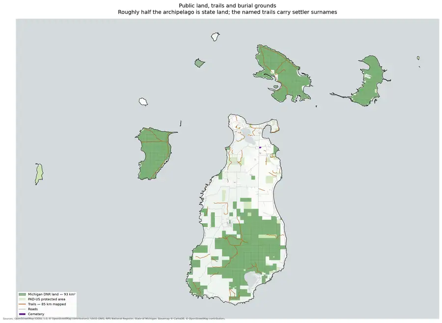
- Beaver Island Archive, *Land ownership and trails* — plate drawn by this project. CC BY 4.0 for the drawing; underlying data under its own terms (see credit)Protected and public land across the archipelago with the trail and track network drawn over it, showing this road in its network context. Credit: Drawn from the archive's own data in EPSG:3078. Map data © OpenStreetMap contributors (ODbL 1.0); protected areas from USGS PAD-US (public domain). No public copy of this file is known; the archive holds one and can provide it on request.output · land_and_trails
Added 2 August 2026. Recent changes
Cite this article
Beaver Island Archive, “Donegal Bay Road”, https://beaverislandarchive.org/places/donegal-bay-road/, accessed [date], citing Kirk D. McBride, Trish Scott, and participants, “Why destroy natural beauty at its peak?,” Beaver Island Forum, June 27–July 30, 2009, topic 1742. (and 2 further sources listed on the page).
Last revised 2026-08-02. Fill in [date] with the date you read it — this page is static and cannot know that.