

- Coordinates
- 45.6026° N, 85.5225° WGoogle Maps: Buffalo’s Camp TrailDownload KML
- Eras
- Modern era
- Concepts
- trailstransportationrecreationModern eratoponymy
- Within
- Beaver Island
- Media
- New puncheon on Buffalo's Camp Trail, 2026 · The Beaver Island Trail Map kiosk at the Y, 2026 · The blank directional signs at the Y, 2026 · The MASH sign, 2026 · The North Lake Trail marker at the Y, 2026
Summary
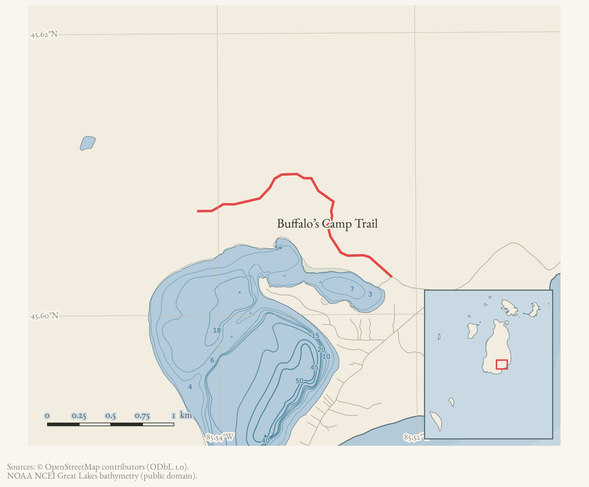
Buffalo’s Camp Trail runs west from the north arm of Lake Geneserath across the middle of the island. The 2021 township description calls it, until Johnny Martin’s Trail is developed, “the only way across the center of the island from East Side Drive to West Side Drive.” OpenStreetMap carries 2.23 km of it; the trail as documented and as walked continues considerably further.
The trailhead is on the road to the Lake Geneserath public access boat launch, 0.25 mile from East Side Drive. There is a birding trail sign there as well as the trail sign.
Official map: North Lake / Buffalo’s Camp Trail (BITA, July 2019). Its route and distance labels are association guidance, not a current access or condition report.
The route, by the township’s own distances
From the trailhead the trail runs west as an old logging road, “mostly quite wide”:
| distance | feature |
|---|---|
| 0.85 mi | a large culvert under the trail |
| 0.93 mi | a second culvert over an obvious stream, four 4x4 posts at the edges |
| 1.60 mi | a wooden bridge; the logging road narrows to single-track |
| 1.70 mi | “the Y” — the branching point, with a DNR “NO ORV” sign |
At the Y the trail divides:
- the right (north) fork is the North Lake Trail, which “gets very wet in 0.6 mile, standing water even in August,” and joins Doty’s Camp Trail 1.17 miles from the Y. At least 0.3 mile of it “is just black muck, even in August.” The federal wetland inventory corroborates that description: 32.6% of the mapped North Lake Trail runs through NWI wetland, against 2.5% for Buffalo’s Camp Trail and 0% for Doty’s.
- the left (west) fork runs 0.75 mile to the MASH sign, which connects to the Blue Trail (West Lake Trail) south, and through Doty’s Camp to Miller’s Marsh and West Side Drive.
Trailhead to Doty’s Camp and on to West Side Drive at Miller’s Marsh is 4.55 miles. A loop out on Buffalo’s Camp Trail, north on the North Lake Trail, down to Doty’s Camp and back through the MASH sign to the Y is 7.04 miles.
The Y sits about 33 m from waypoint P on the 2015 trail map’s GPS panel (45°36’31.8“N, 85°32’53.0”W), and the trail association’s Blue Trail sheet gives O→P as 0.7 mile against the township’s 0.75 mile from the Y to the MASH sign. The two are therefore probably the same junction, described from opposite directions by different authors.
Where OpenStreetMap ends it, and what is beyond
OSM’s line stops at 45°36’26.6“N, 85°32’31.8”W — 2.23 km from the trailhead, short of the Y. The 1986 quadrangle, georeferenced from its own embedded transform, draws the dashed trail continuing roughly 2.7 km further: west along the same line, then turning north-north-west toward a route marked 4WD.
The continuation is walked, and it runs further than the archive knew. On 16 August 2026 a single traverse left the trailhead at 19:05 UTC and reached waypoint V at 21:58 — 5.59 miles at 1.95 mph overall, of which 4.65 miles were at tread pace (median 2.36 mph) against 0.24 mile of pushing through cover (median 0.67 mph). Tread-walking on this island runs about 1.9–2.5 mph and bushwhacking well under 1.25 mph, so the distinction is not a fine one.
The five 250 m segments immediately west of OSM’s end — digitised from the 1986 sheet, and confirmed at tread pace in the 2024-25 tracks — were re-walked in 2026 at 3.05, 2.80, 2.55, 1.80 and 1.43 mph. Two visits two years apart, agreeing. The trail is there.
Past them, the 1986 dashed symbol is still unwalked. Six further 250 m segments run north-north-west toward the route the sheet marks 4WD. The 2026 traverse came no closer than 115 m to the first and 1,249 m to the last; it turned south instead. Nothing has been added to that stretch of the record.
The north leg — the North Lake Trail fork — has still not been walked in any track held here. The 2026 traverse’s nearest approach to the mapped North Lake Trail is 1,308 m. The township’s own description of standing water and black muck remains the reason to expect that ground to be uninformative rather than empty.
The left fork reaches the Blue Trail
The 2019 walked account has the left fork dead-ending at the Blue Trail about 0.75 mile past the Y. The 2026 traverse measures the Y to the MASH sign at 0.79 mile, against the township’s 0.75 mile and the trail association’s 0.70 mile for O→P. Three independent sources and one measurement inside a tenth of a mile of each other: the left fork does reach the Blue Trail, and the MASH sign is where it does.
From the MASH sign the traverse continued south 2.88 miles to waypoint V, which sits on the Blue Trail’s own waypoint spur. That is the first walked geometry this archive holds for any part of that route.
What the junctions look like, August 2026
Photographs from the same traverse record the state of the signage.
At the Y, two wooden directional boards stand on a post and both are blank — the paint weathered off, leaving a faint incised arrow on one and illegible traces on the other (photograph). Twenty-six seconds later the walker photographed a clean, fully legible North Lake Trail marker on the same junction (photograph). The fork is signed; the older boards beside it are spent.
A Beaver Island Trail Map kiosk stands at the Y as well (photograph), and it is the most useful object in the set: its GPS Coordinates panel gives entries A to N, and all fourteen match this archive’s transcription of the 2015 printed sheet to the second of arc.
About 1.9 miles in, new puncheon — freshly milled lumber — has been laid over standing water (photograph), on a route whose own trail-association sheet warns of impassable wet areas.
At the far end of the left fork, the MASH sign carries five hand-painted arms with distances, and a blue diamond blaze is fixed to a cedar beside it.
One further observation, recorded without a location: an elevated hunting stand stands within sight of the tread near the three-mile mark. It is a private and movable structure on ground the walk records as inside a public holding, and this archive maps neither the stand nor its owner.
A gap in the tread, and it is not the wetland
One stretch of the traverse is not tread at all: 0.23 mile centred on 45.60031, −85.56046, taking 18.5 minutes at 0.67 mph with the walker’s heart rate at 167 bpm. Speed and effort agree that this was cover-pushing rather than walking, which is a stronger reading than either gives alone.
It does not fit the wetland explanation below, and should not be filed under it: 1 % of that stretch falls inside a mapped NWI wetland. It is dry ground. Either the tread breaks there or the blazing does — and on a trail blazed with a blue diamond on a white border, those are different problems with different remedies.
The line moves: meandering through wetland
Local knowledge from the walker whose tracks are cited here: the trail meanders in places because of the wetlands. It is not a fixed line that a sheet either draws correctly or does not — it works around wet ground, and where the ground changes the line changes with it.
That has three consequences for anything measured against it:
- A walked track and a mapped line can differ by more than the map’s own accuracy without either being wrong. Distances of tens of metres between the 1986 dashed symbol and a 2024 GPS trace are expected here, not evidence of misregistration.
- It is a candidate explanation for a control failure in this archive’s own testing. When 1986 ink coverage was measured along trails the sheet certainly drew, Doty’s Trail separated cleanly from its null (79% against 19%) while Buffalo’s Camp Trail did not (37% against 35%). Doty’s is an old logging grade and holds its line; a route that moves defeats a 25 m tolerance. The federal wetland inventory only partly supports this: it puts Doty’s at 0% of its length in mapped wetland against Buffalo’s Camp at 2.5% — the right direction but a thin margin, and NWI does not map the small wet patches a walker actually detours around. Offered as the most likely explanation, not as a demonstrated cause.
- The published leg distances behave accordingly: the trail association’s own figures run 1.06 to 1.49 times the straight line between waypoints, which is what a route bending around wet ground does.
Why the LiDAR is quiet here, and why that means little
The 1 m bare-earth LiDAR shows nothing along the mapped continuation. That is much weaker evidence than it appears. Measured against these same GPS tracks, the archive’s roughness method detects only 5 of 12 trails known to exist — and it misses almost everything under 400 m. The three segments it says nothing about were walked at 3 km/h.
A wet, mucky, standing-water trail through swampy ground also leaves no firm prism to detect, which is exactly what the township describes along the north fork. And a trail that meanders leaves its signal spread across a corridor rather than concentrated on a line, which is the condition a narrow-window roughness measure is worst at seeing.
A trail that is easy to wander onto
South of the MASH sign the 1986 USGS quadrangle draws a dashed trail running south for about a mile, and it is still walkable. It is on no current sheet, carries no name in any source held here, and is described at The unnamed trail west of Lake Geneserath.
The hazard is that nothing marks where the maintained network stops. A walked track of 16 August 2026 followed that old line for nine-tenths of a mile at a median 8 m from the mapped symbol, at ordinary walking pace, without recording a junction — and then lost the tread entirely, spending eighteen and a half minutes on 0.23 mile of cover-pushing on dry ground.
If you are heading south from the sign and expecting a maintained trail, this is the thing to know about.
Access and ownership
The trailhead sits on the road to the Lake Geneserath public boat launch, which the 2024 Peaine Township Parks and Recreation Plan’s asset table lists as Michigan DNR land leased to Peaine Township (“MDNR leased by PT”), with a trail among the site’s listed features. The township’s 2021 description records a DNR “NO ORV” sign posted at the Y, where the North Lake Trail forks off — evidence of DNR involvement in managing use at that junction, though not a title record for the corridor as a whole. The same plan places much of southern Peaine Township, which this trail crosses, within the Beaver Islands State Wildlife Research Area; the archive holds no parcel-level survey confirming exactly which stretches of the trail fall inside that boundary.
No source held here documents who owns or manages the ground west of the Y, where OpenStreetMap’s line ends and the walked and 1986-quadrangle evidence continues — see Open questions below.
The Beaver Island Trail Association’s July 2019 sheet for this trail carries its standard seasonal-hazard caution and disclaimer, current as of that date and not updated since:
“This is a wilderness area. You may encounter impassable wet areas due to seasonal conditions.”
“BIATA Trail Maps are not official DNR maps. They were prepared as an imperfect visual guide for the user and should not be relied upon for complete accuracy. Trails can become overgrown and unrecognizable in many areas. Although BIATA has made every reasonable effort to prepare representative maps, users assume the risk of any errors or inaccuracies.”
There are no designated public ORV trails on Beaver Island; the DNR “NO ORV” sign at the Y is consistent with that island-wide policy rather than an exception to it (see Trails and trail-making).
Evidence and limits
This trail is supported by different registers over different stretches. It is published — in the 2015 map, the 2019 BITA sheet and the 2021 township narrative. It is mapped in OpenStreetMap for its first 2.23 km. It is walked: five 250 m segments immediately beyond OSM’s end were GPS-tracked at tread pace in 2024-25 and again on 16 August 2026, and the 2026 traverse carried on through the Y to the MASH sign and south to waypoint V. Along the North Lake Trail fork it has been searched, with nothing conclusive found — and the 2026 traverse did not improve on that: its nearest approach to the mapped North Lake Trail is 1,308 m. The swampy ground the township guide describes is exactly the condition under which the archive’s LiDAR method is least reliable, as discussed above. A walked account contributed in 2019 describes both forks, though without geometry. See North Lake Trail.
One caution on reading pace as condition. Across the 2026 traverse the walker’s heart rate climbs from a median of 116 bpm in the first hour to 169 in the third, so the same 2.1 mph costs about half again as much effort late in the walk as early. Pace remains the tread test this archive uses, because it is the test the earlier verdicts were made with and comparability matters more than refinement — but a single figure from late in a long walk is not evidence that the tread there is worse than the tread at the start.
Open questions
- Has anyone walked the North Lake Trail fork from the Y with a GPS? Still open after 2026: that traverse passed 1,308 m away at its nearest. A 2019 walked account describes the fork and the township guide publishes distances for it, but no track and no mapped line covers the branch.
- Why is there a 0.23-mile break in the tread at 45.60031, −85.56046? The 2026 traverse crossed it at 0.67 mph on ground that is 1 % mapped wetland, so the usual wet-detour explanation does not apply. Is the tread genuinely discontinuous there, or were the blue diamonds simply not findable in August cover?
- Do the six 1986 segments north-north-west of the confirmed stretch carry tread? They remain unwalked; the 2026 traverse turned south 115 m short of the first of them.
- Who manages the roughly 2.7 km of trail west of OpenStreetMap’s end, walked at tread pace in 2024-25 and again in 2026? No ownership source held here covers it.
- Does the DNR “NO ORV” sign at the Y reflect a documented management decision specific to this trail, or only the island-wide absence of designated ORV trails? No source ties the sign itself to a dated DNR order.
If you can answer any of these, or correct anything above, the archive wants to hear it — see Corrections.
Documented associations
No source-confirmed non-road entity is linked yet. Exact-name research leads remain in scripts/audit_road_links.py; a name collision is not treated as a road association.
Research status
The local newspaper and website corpus contains exact-name mentions in 0 file(s). Those files are research leads; the relation layer is added only when the surrounding source text establishes that the record involves this road.
Maps for this place
These Atlas plates provide regional context. They do not establish a precise boundary, current ownership, access right, operating status, or field condition.
- EnvironmentSoils, wetlands, hydrography, and terrain
- GeologyGeneralized geology and landforms
- HydrologyMapped water and wetland context
- AccessMapped routes, facilities, and protected areas
- Land surveyPLSS geometry and historic GLO patent-location context
Sources
- The legend prints Buffalo’s Camp Trail.
- Names Buffalo’s Camp Trail and discusses the island trail system. URL dead as of 2026-08-08 (404); no live copy found on peainetwp.org or webgen1files1.revize.com. Not held. For trail geometry see instead the BITA North Lake / Buffalo's Camp Trail sheet (July 2019), held at data/governance/peaine/trails/bita-north-lake-buffalos-camp-trail-2019-07.pdf.
- Current named OSM way 265426155, simplified for display.osm · trails
- Per-trail sheet issued by the trail association. Held locally 2026-08-08; retrieved from peainetwp.org after the address cited elsewhere in this knowledge base (cms5.revize.com) began returning 404.governance · peaine · trails · bita-north-lake-buffalos-camp-trail-2019-07
- States a complete loop using the Blue Trail, Buffalo's Camp Trail and East Side Drive/South End Road is 7.5 miles, and notes a spur joining the two at map notation O, the MASH sign.governance · peaine · trails · bita-blue-trail-2019-07
- Walking directions with distances: culverts at 0.85 and 0.93 miles, a wooden bridge at 1.60 miles where the logging road narrows to single-track, and "the Y" at 1.70 miles. Records a birding trail sign at the trailhead.governance · peaine · trails · all-trail-descriptions
- Walked GPS tracks, Beaver Island south end, 2024-07-14, 2024-07-17 and 2025-07-19.Supplied by M. Bommarito. 37.5 km of track after removing export gaps. Used here to test where tread exists west of the mapped end: walking pace distinguishes following a trail from pushing through cover. No public copy of this file is known; the archive holds one and can provide it on request.fieldwork · gps_tracks
- USGS Beaver Island South, 7.5-minute quadrangle, 1:24,000, provisional edition 1986.Georeferenced from the GeoPDF's embedded LGIDict by scripts/georeference_topo.py. Draws a dashed trail continuing about 2.7 km west and north-north-west of where OpenStreetMap ends the trail. No public copy of this file is known; the archive holds one and can provide it on request.federal · usgs_topo · georeferenced · Beaver-Island-South_1986_24000_275634
- Table 3.1 lists the Lake Geneserath Public Access site, at this trail's trailhead, as MDNR land leased by Peaine Township, with a trail among its listed features. Section 1 places much of southern Peaine Township within the Beaver Islands State Wildlife Research Area.governance · peaine · trails · peaine-park-and-rec-plan-draft-2023-11-27
- Kamrin, Michael. 'An Insiders Guide to Beaver Island Hiking Trails: A Companion to the Wojan/Cashman Beaver Island Map.' Unpublished typescript, created 8 August 2019, last revised 17 February 2020.Walked account of the trail from the East Side Road end. Gives the trailhead off Fishing Site Road, parking at the North Arm boat launch, Birding Trail marker #20, and the trail starting as a dirt road that narrows, 'lined by wild blueberry bushes.' Puts a large culvert about 0.75 mile in and the signed divide about 0.75 mile beyond that, and records the left fork as the original trail, less maintained, dead-ending at the Blue Trail about 0.75 mile on. Records the trail's blaze as a blue diamond with a white border.fieldwork · accounts · kamrin-insiders-guide-bi-hiking-trails
- Walked GPS track, Buffalo's Camp Trail trailhead to waypoint V, 16 August 2026.5.59 miles over 1,904 fixes, 19:05-21:58 UTC, 1.95 mph overall; 4.65 mi at tread pace (median 2.36 mph), 0.44 mi slow, 0.24 mi pushing through cover (median 0.67 mph). Recorded with heart rate. Exported as GPX/CSV/GeoJSON; the original FIT was not supplied, so there is no per-fix accuracy channel and canopy drift cannot be separated from the trail's real meander. Ingested by scripts/ingest_gps_track.py.fieldwork · gps_tracks · beaver-south-2026-08-16-5.59mi
Added 2 August 2026 · revised 21 August 2026. Recent changes
Cite this article
Beaver Island Archive, “Buffalo’s Camp Trail”, https://beaverislandarchive.org/places/buffalos-camp-trail/, accessed [date], citing Beaver Island trails map, revised October 2015. (and 10 further sources listed on the page).
Last revised 2026-08-21. Fill in [date] with the date you read it — this page is static and cannot know that.
BibTeX for “Buffalo’s Camp Trail”RIS for “Buffalo’s Camp Trail”