

- Along road
- Fishing Site Road · East Side Drive · Fox Lake Road · Mrs Redding Trail · Camp #3 Trail · Greene's Lake Road · Hannigan's Road · South French Bay Road + 3 more
- Coordinates
- 45.6234° N, 85.5371° WGoogle Maps: Beaver Islands State Wildlife Research AreaDownload KML
- Eras
- Modern era
- Concepts
- conservationenvironmentrecreationgovernment
- Within
- Beaver Island archipelago
Summary
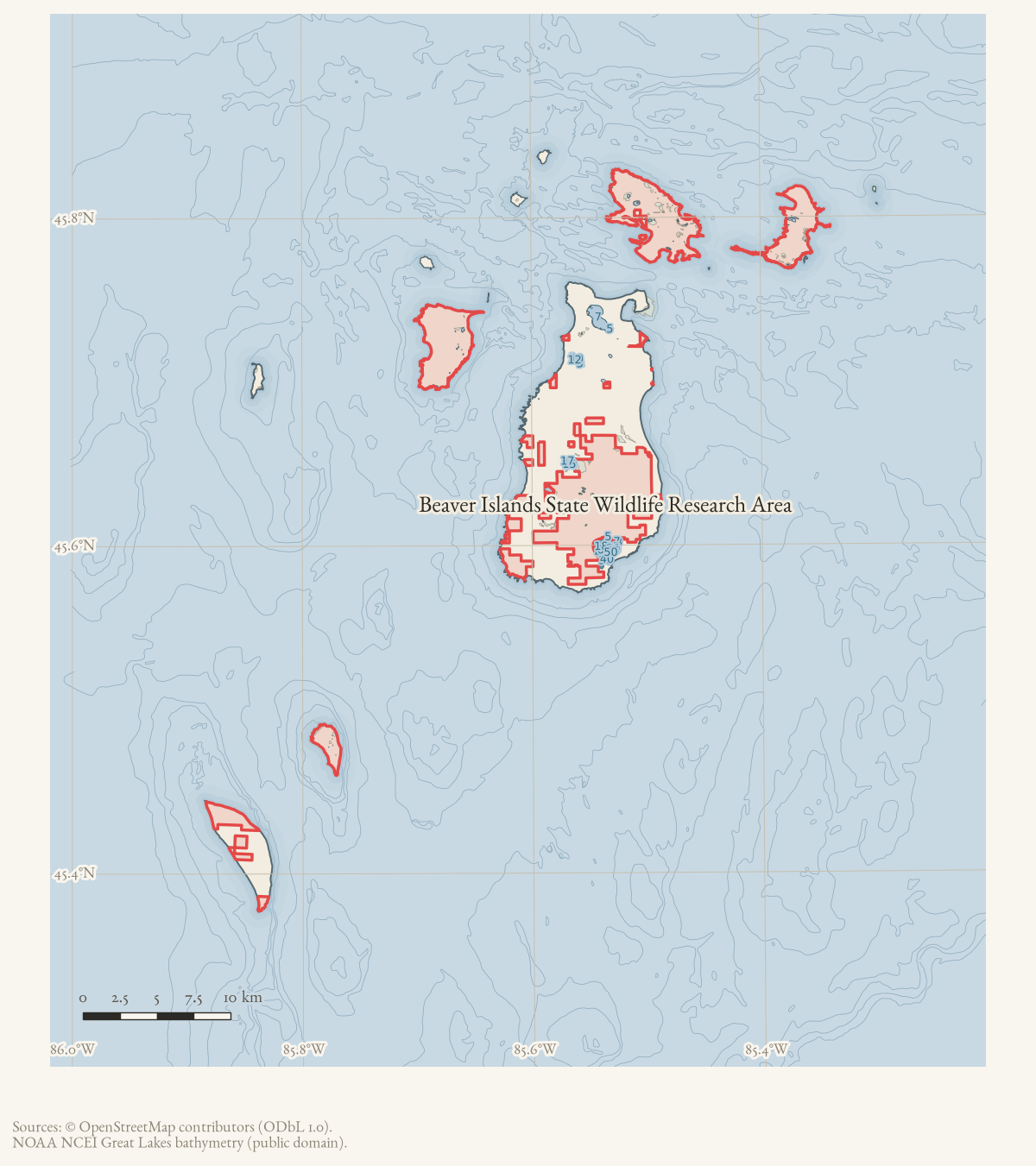
Beaver Islands State Wildlife Research Area is a Michigan Department of Natural Resources public-land designation covering substantial state-managed land in the Beaver Island archipelago, dating from the 1970s.1 Local reporting places 9,195.5 acres of the Beaver Island portion within the 2024 Beaver Island State Wildlife Research Area International Dark Sky Sanctuary.2 Current mapping shows the designation as a discontiguous multipolygon crossed by numerous island roads and trails.
This page uses a representative point rather than presenting the volunteered OSM multipolygon as a surveyed legal boundary. The listed road links mean that current mapped road ways intersect the OSM relation; they do not imply that every address along a road lies on state land.
Designation and management history
A 2024 Northern Islander history of the Beaver Island trail network places the research-area designation against an earlier layer of state activity: the DNR cut fire trails across the island in the 1940s and 1950s, and “in the 1970’s the Beaver Island Archipelago was designated a Wildlife Research Area.” The same account describes the DNR’s subsequent management as largely hands-off with respect to trails maintenance — Peaine Township’s own Trails Committee did that work — until 2013, when the state adopted new land-management policy for the property, and 2017, when the DNR set out a management vision built on partnership among townships, tribal groups, and conservancies. Its 2017 report is quoted stating that “the degree of human impact should decrease in proportion to increasing levels of ecological, historical and cultural sensitivities.”1
State game regulations from the research area’s early years show it managed as its own deer-hunting unit. Charlevoix Courier hunting-season notices for 1969 and 1970 list it as “Area 27, the Beaver Islands Wildlife Research Area,” open to antlerless deer hunting on a “come-and-get-them” permit basis at the DNR’s Beaver Island field office in Saint James, rather than through the mail-in application required for other units.34 A May 1986 closure order extended a Great Lakes piping-plover protection measure, in effect through August 15, to beach nesting sites within the Beaver Island Wildlife Research Area, one of several northern Lake Michigan and Lake Superior public shorelines posted that year after the state’s plover population fell to 19 breeding pairs.5 The Michigan DNR issued a comparable 1941 order closing part of the archipelago to protect sharp-tailed grouse; see Michigan Conservation Commission Beaver Island Sharp-Tailed Grouse Closure Order, 1941 for that earlier, separately sourced closure.
Evidence and limits
The DNR designation, local acreage report, and OSM relation establish the research-area entity. Parcel ownership, management-unit boundaries, and public access vary across the archipelago and require the DNR’s parcel records or a current management map for finer-grained claims. The 1970s designation date rests on one 2024 secondary retrospective rather than the DNR’s own establishing order, which is not separately held here.
Open questions
- What is the DNR’s original establishing order or regulation for the research-area designation, and its exact date?
- How have the area’s management-unit boundaries and deer-hunting rules changed between the 1969-70 and current regulations?
- Does the 2017 DNR island management plan set out boundaries or access rules not yet captured in this record?
If you can answer any of these, or correct anything above, the archive wants to hear it — see Corrections.
See also
Footnotes
-
Ken Zick, “The Origins and Scope of the Beaver Island Archipelago Trails Association,” Northern Islander, August 2024. ↩ ↩2
-
Northern Islander, May 2024, “Dark Sky Sanctuary.” ↩
-
Charlevoix Courier, 1969, antlerless deer permit and hunting-unit notice. ↩
-
Charlevoix Courier, 1970, antlerless deer permit and hunting-unit notice. ↩
-
Charlevoix Courier, 1986, “Northern Great Lakes beach sites closed to protect piping plovers.” ↩
Maps for this place
These Atlas plates provide regional context. They do not establish a precise boundary, current ownership, access right, operating status, or field condition.
- EnvironmentSoils, wetlands, hydrography, and terrain
- GeologyGeneralized geology and landforms
- HydrologyMapped water and wetland context
- AccessMapped routes, facilities, and protected areas
- Land surveyPLSS geometry and historic GLO patent-location context
Sources
- The DNR list identifies Beaver Islands State Wildlife Research Area as a state wildlife area. The agency page is authoritative for the designation but does not provide a parcel-by-parcel island boundary in this record.
- Northern Islander, May 2024, “Dark Sky Sanctuary.”Reports that the sanctuary includes 9,195.5 acres of the State Wildlife Research Area on Beaver Island, owned and managed by the Michigan DNR, and describes the 2024 DarkSky certification. No public copy of this file is known; the archive holds one and can provide it on request.
- Contemporaneous forum discussion links to an April 9 Interlochen Public Radio report, celebrates the designation, and announces a planned September 20 dedication. It does not itself establish the formal certification instrument, boundaries, or dedication outcome.forum · www.beaverislandforum.com · 18 · t018086
- Relation 13401360 is tagged as a Michigan DNR nature-reserve multipolygon. Its discontiguous volunteered geometry is retained as a representative map point here; road associations are based on direct intersections between the relation and current named road ways, not on address claims.osm · protected_areas
- PIN 012-003-001-00 is a 444.3-acre exempt parcel owned by the Michigan Department of Natural Resources, with current situs East Side Drive Access and a representative point near the OSM research-area locator. It confirms current DNR land context for part of the discontiguous area, but does not define the full research-area boundary.county · charlevoix · parcels_arcgis · 2026-08-01 · island_parcel_attributes
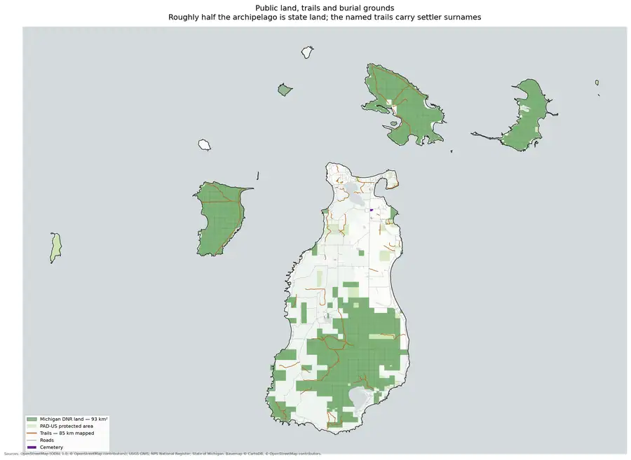
- Beaver Island Archive, *Land ownership and trails* — plate drawn by this project. CC BY 4.0 for the drawing; underlying data under its own terms (see credit)Protected and public land across the archipelago with the trail and track network over it, showing this holding among the other public land. Boundaries are drawn from the protected-areas layer and are not a survey or a statement of access rights. Credit: Drawn from the archive's own data in EPSG:3078. Map data © OpenStreetMap contributors (ODbL 1.0); protected areas from USGS PAD-US (public domain). No public copy of this file is known; the archive holds one and can provide it on request.output · land_and_trails
- Ken Zick, "The Origins and Scope of the Beaver Island Archipelago Trails Association," Northern Islander, August 2024.States the Beaver Island Archipelago was designated a Wildlife Research Area in the 1970s, describes DNR fire-trail cutting in the 1940s-50s, and describes 2013 and 2017 DNR land-management policy changes, quoting the 2017 Wildlife Division report. No public copy of this file is known; the archive holds one and can provide it on request.
- Charlevoix Courier, 1969, antlerless deer permit and hunting-unit notice.Lists the Beaver Islands Wildlife Research Area as Area 27, open to antlerless deer hunting on a come-and-get-them permit basis at the DNR's Beaver Island field office rather than by mail application. No public copy of this file is known; the archive holds one and can provide it on request.
- Charlevoix Courier, 1970, antlerless deer permit and hunting-unit notice.Repeats that sportsmen may hunt antlerless deer without mail-in permits in the Beaver Islands Wildlife Research Area that season. No public copy of this file is known; the archive holds one and can provide it on request.
- Charlevoix Courier, 1986, "Northern Great Lakes beach sites closed to protect piping plovers."Reports a DNR closure order, in effect through August 15, 1986, protecting piping plover nesting beaches including sites within the Beaver Island Wildlife Research Area, after Michigan's plover population fell to 19 breeding pairs in 1985. No public copy of this file is known; the archive holds one and can provide it on request.
Added 2 August 2026 · revised 6 August 2026. Recent changes
Cite this article
Beaver Island Archive, “Beaver Islands State Wildlife Research Area”, https://beaverislandarchive.org/places/beaver-islands-state-wildlife-research-area/, accessed [date], citing Michigan Department of Natural Resources, State Wildlife and Game Areas list, retrieved 2026-08-02. (and 9 further sources listed on the page).
Last revised 2026-08-06. Fill in [date] with the date you read it — this page is static and cannot know that.
BibTeX for “Beaver Islands State Wildlife Research Area”RIS for “Beaver Islands State Wildlife Research Area”