

- Intersects
- West Side Road · Western Shores Road
- Coordinates
- 45.6805° N, 85.5919° WGoogle Maps: Mrs Redding TrailDownload KML
- Eras
- Modern era
- Concepts
- trailstransportationtoponymy
- Within
- Beaver Island archipelago
- Media
- Beaver Island History Map, 1978 revision
Summary
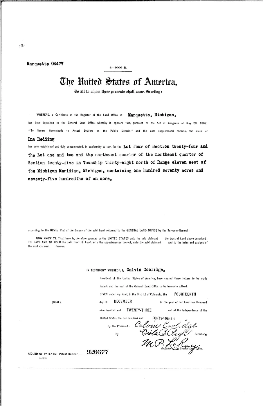
Mrs Redding Trail is a named road on Beaver Island’s current OpenStreetMap map. A federal patent issued in 1923 granted Ina Redding 170.75 acres in west-side Sections 24–25. The Beaver Beacon calls the route Redding Trail in 1973 and in 1976 describes Mrs. Redding’s old cabin near its far end. Together these sources establish the person, homestead, route name, and cabin-at-the-end association more firmly than the map alone. It is also a county local road: the Charlevoix County Road Commission designated it a Natural Beauty Road in 2005, after a petition process that took more than two years and one earlier denial.
The route
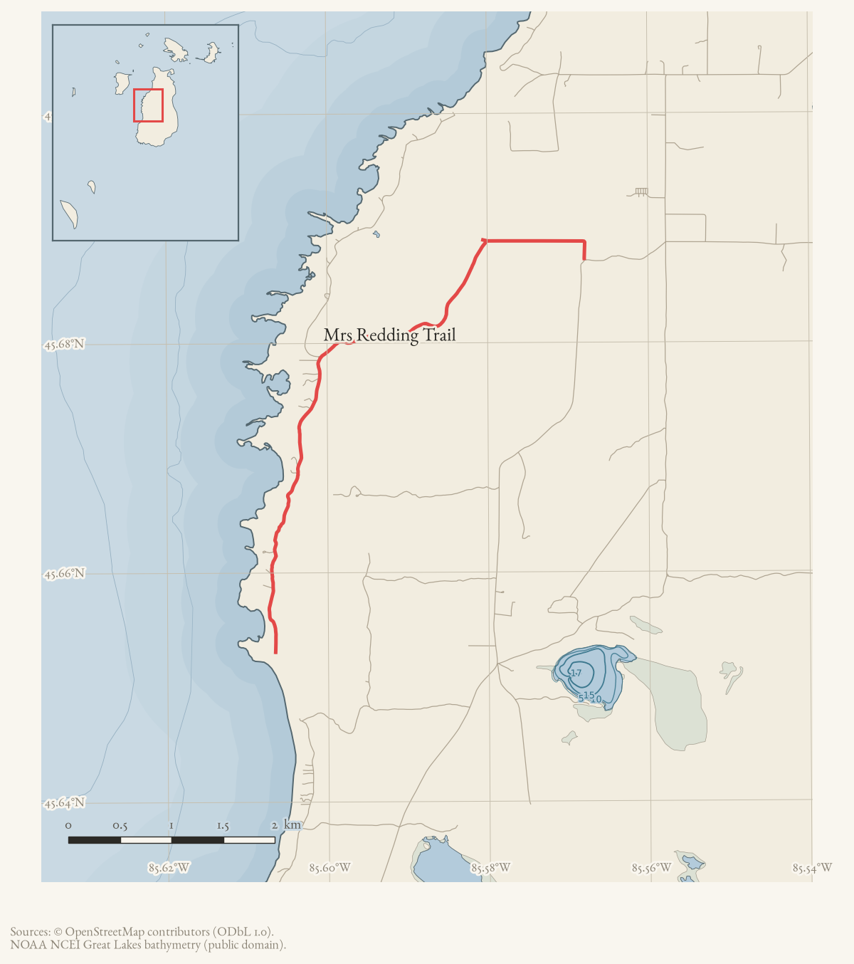
Published, mapped, and legally described. The Road Commission’s own 2005 resolution gives the certified length precisely: 2.96 miles, commencing at the intersection with West Side Road and ending “at the north property line of Federal Property (which is the end of Road Commission certification),” through Sections 17, 18, 13 and 24 of T.38-39N.-R.10-11W. That is the fullest figure held for the route; OpenStreetMap’s current geometry, grouped from way ids 17760488 and 17760589, is what contributors last mapped and is not represented here as a survey.
The road runs from the West Side Road/Western Shores Road junction on top of Angeline’s Bluff south toward Greens Bay. The Natural Beauty Road designation covers the stretch from that junction to the section labeled “Seasonal Road” further south, per the 2006 Beacon report below.
What the route was
The 1978 Historical Map calls Redding’s Trail an extension of the Peshawbe’s Town trail; the 1905 Peshawbestown settlement it names sat “along what is now Mrs. Redding’s Trail,” per the township’s own recreation-plan history. No early plat, road record, or first-person account located in this pass establishes that predecessor alignment as a continuous route, but the association between the road and the former settlement is independently recorded in both the 1978 map and the 2023-24 recreation plan.
Points of interest
The recreation plan places two public sites directly on the road: the Vincent Rice Memorial Observation Deck at Angeline’s Bluff, near the West Side Road junction, and the 106-acre Sarah A. Martin Nature Preserve, reached by two access strips off Mrs. Reddings Trail and West Side Road. Further south, Oliver’s Point is Michigan DNR land reached by a short trail “several miles down Mrs. Redding’s Trail,” marked with a sign; in 2019 high Lake Michigan levels forced that spur trail to veer north and left no beach that year.
History
A petition to designate the road a Natural Beauty Road went to the Road Commission in 1998 or earlier and was renewed by 2003, when forty-six residents’ signatures and thirteen letters of support were presented at a June 2003 public hearing. Residents disagreed there about whether curves needed widening first; the Commission voted in October 2003 to deny the designation until safety improvements were complete, on Peaine Township’s own written recommendation. The township reported in December 2004 that the dangerous spots had been “straightened out through tree clearing” and told the Commission it was ready. A second public hearing followed on 13 June 2005, and the Commission adopted the designation resolution that day under Act 451 of 1994. A Beacon report the following May credited resident Barb Spencer’s two-year petition and presentation effort and dated the designation in less specific terms — “now… declared” — about eleven months after the Commission’s own resolution; the contemporaneous Road Commission minutes are preferred here for the date.
Access and ownership
The road itself is public — a Charlevoix County local road, Natural Beauty Road-designated since 13 June 2005 — but access along it is not uniformly settled, and the record includes a documented dispute.
In September 2017, island residents living at the trail’s south end (posting as “Fschoo”) reported repeated trespassing: tourists parking on and driving across their property toward state dune land, including into critical dune habitat, after “No Trespassing” signs had been posted. One reply argued that county equalization maps show Mrs. Reddings Trail crossing that property and the lot to its south, and recalled a gate erected there in the early-to-mid 1990s that “was taken down because Mrs Reddings trail IS the public access to the dunes.” The property owner, in a later post, confirmed a gate had once stood there — visible, he said, on the Wojan map — and said he knew who had removed it, without naming that person; he also stated the road past a certain point is not a Road Commission responsibility and that upkeep there falls to adjoining owners. Neither claim is a deed, easement, or court ruling, and the archive holds no independent record settling whether the public has an established right of way across the disputed parcel.
Downstream of that dispute, the 2023-24 recreation plan records Oliver’s Point itself as Michigan DNR land, but describes access to it explicitly as “Public; access over private land” — consistent with the forum account that the road crosses private parcels before reaching state land.
Natural Beauty Road status, under the state law revised in 1995, protects roadside foliage within the right-of-way from destruction or substantial damage; it does not by itself establish or extinguish anyone’s access rights, and the Road Commission noted in 2005 that the designation can be reversed. No ORV designation applies: there are no designated public ORV trails on Beaver Island. Nothing here should be read as a current guarantee of access or used for navigation.
Names
The trail is printed four ways in the sources, and the form a reader searches on decides what they find:
- Redding Trail — Beaver Beacon, August 1973.
- Reddings Trail — Beaver Beacon, February 1976.
- Redding’s Trail — 1978 Historical Map.
- Mrs Redding Trail — current OpenStreetMap form.
Evidence and limits
The current geometry is what OpenStreetMap contributors last entered. It is not a surveyed right-of-way and cannot be projected backward as the full historical trail. The 1978 map calls Redding’s Trail an extension of the Peshawbe’s Town trail, but no early plat, road record, or first-person account located in this pass establishes that predecessor alignment.
The map also says Mrs. Redding lived alone at the trail’s end. Her remote cabin is supported, but a 2026 Historical Society exhibit feature describes seasonal winters in Chicago, visiting relatives, and a later move nearer town. The map’s phrase is therefore treated as a compact homestead description rather than a complete statement about her household over time.
Open questions
- Was the gate recalled at the trail’s south end — erected in the early-to- mid 1990s and later removed, per the 2017 forum thread — ever formally authorized by the Road Commission or a landowner, or removed without authority? The property owner said he knew who removed it but did not name that person, and no record held here settles it.
- Has the Peshawbestown settlement site the 1978 Historical Map and the township’s recreation plan place at the foot of Angeline’s Bluff ever been archaeologically surveyed? No survey is cited in any source held here.
- Do the county equalization maps the 2017 forum reply describes actually show Mrs. Reddings Trail crossing the disputed south-end parcel as a public right of way? The archive holds no independent copy of that map.
If you can answer any of these, or correct anything above, the archive wants to hear it — see Corrections.
Documented associations
These source-backed records provide context for the mapped route:
- Beaver Island road committee repair list, 1994 — At the St. James township report dated May 4, 1994, the Beaver Island road committee gave the Road Commission a list of repair needs. The list named Mrs. Redding’s Trail, Barney’s Lake Road, Hannigan Road, and Mike Boyle’s Turnaround, among other island routes, and said an engineer would meet with the committee on May 13. The notice records a repair-planning…
- Landscapes by Barb — Landscapes by Barb is the business name used in a 2011 Charlevoix Courier notice for Barbara Rahn at 33171 Mrs. Redding’s Trail on Beaver Island. The notice is enough to connect the business and person to the road, but it does not establish the services offered, incorporation, duration, or present status.
- Beaver Islands State Wildlife Research Area — Beaver Islands State Wildlife Research Area is a Michigan Department of Natural Resources public-land designation covering substantial state-managed land in the Beaver Island archipelago, dating from the 1970s. Local reporting places 9,195.5 acres of the Beaver Island portion within the 2024…
- Oliver Point — Oliver Point is a GNIS-named cape on Beaver Island. The September 1967 Beaver Beacon reports severe insect defoliation in a hardwood stand inland from Oliver’s Point and quotes state forester Jack Lockwood’s conclusion that buds and beechnuts were developing normally despite the leaf loss. The 2023 Beaver Island Master Plan also labels “Oliver’s Point”…
- Sarah A. Martin Nature Preserve — Sarah A. Martin Nature Preserve is a Little Traverse Conservancy preserve identified in the 2023 Beaver Island Master Plan as a 106-acre working-forest reserve on Mrs. Redding’s Trail. The Conservancy’s Beaver Island preserves flyer lists the same preserve among its public nature preserves. The OSM polygon supplies a current mapped representation and…
Research status
The local newspaper and website corpus contains exact-name mentions in 0 file(s). Those files are research leads; the relation layer is added only when the surrounding source text establishes that the record involves this road.
Maps for this place
These Atlas plates provide regional context. They do not establish a precise boundary, current ownership, access right, operating status, or field condition.
- EnvironmentSoils, wetlands, hydrography, and terrain
- GeologyGeneralized geology and landforms
- HydrologyMapped water and wetland context
- AccessMapped routes, facilities, and protected areas
- Land surveyPLSS geometry and historic GLO patent-location context
The page
Rendered from the held scan.
Sources
- Current mapped road name 'Mrs Redding Trail'; grouped OSM way ids: 17760488, 17760589. This is a volunteered map record, not a surveyed right-of-way or proof of historical naming.osm · roads
- Primary federal record grants Ina Redding 170.75 acres in west-side Sections 24–25. It establishes the homestead but not the route’s exact historical alignment. The holder's public portal is searchable but does not link this record directly; the archive holds a copy of the file and can provide it on request.federal · glo · patents · 10237654941762632324-patent-ser-926677
- Earliest held newspaper use located in this pass; it calls the route Redding Trail but does not explain the name.data1 · beaver-island-archive · beaver_beacon · 1973-08_Beaver-Beacon
- Describes an old house at the far end of Reddings Trail and Mrs. Redding’s old cabin just south of the party’s stop. The holding institution's portal restricts automated access; the archive holds a copy of this issue and can provide it on request.data1 · beaver-island-archive · beaver_beacon · 1976-02_Beaver-Beacon
- Described in this archive: Beaver Island History Map, 1978 revision.Calls Redding’s Trail an extension of the Peshawbe’s Town trail and says Mrs. Redding lived alone at its end. The homestead/cabin association is corroborated, but the predecessor route and uninterrupted solitary residence are not.
- A property-owner complaint described trespass, vehicle tracks, and damage concerns near the end of the trail; replies disputed or questioned whether the route provides public access to the dunes and referred to an equalization map and local recollections. This is a contested forum account, not a deed, easement, court ruling, or surveyed right-of-way determination.forum · www.beaverislandforum.com · 12 · t012240
- Charlevoix County Road Commission, 2003 regular board meeting minutes.Records a June 2003 public hearing on a petition (forty-six signatures, thirteen letters of support) to designate Mrs. Reddings Trail a Natural Beauty Road, and the Commission's October 2003 vote to deny the request until curve-widening and sight-distance safety improvements were complete, on Peaine Township's written recommendation.governance · township_meetings · charlevoix-road-commission · 2003-regular-board-minutes-07cfa24e13
- *Beaver Beacon*, December 2004, Peaine Township meeting report.Reports the township board's view that the dangerous spots in Mrs. Reddings Trail had been straightened out through tree clearing, and its decision to tell the Road Commission it was satisfied and ready for the Natural Beauty Road designation to proceed.
- Charlevoix County Road Commission, 2005 regular board meeting minutes.Records a 13 June 2005 public hearing and the Commission's resolution, adopted the same day under Act 451 of Public Acts of 1994, designating Mrs. Reddings Trail a Natural Beauty Road for 2.96 miles, from the West Side Road intersection to the north property line of federal property (the end of Road Commission certification), in Sections 17, 18, 13 and 24, T.38-39N.-R.10-11W.governance · township_meetings · charlevoix-road-commission · 2005-regular-board-minutes-e98bfa160a
- *Beaver Beacon*, May 2006, 'New Natural Beauty Road'.Reports the designation as accomplished, crediting resident Barb Spencer's two-year petition and presentation effort, and describes the Natural Beauty section as running from the West Side Road intersection atop Angeline's Bluff to the southern section labeled 'Seasonal Road.' Published about eleven months after the Commission's own June 2005 resolution.
- Recreation-site table lists Oliver's Point as MDNR land off Mrs. Redding's Trail on the west side, with a trail to Lake Michigan, public beach and 0.4 mile of shoreline, access noted as 'Public; access over private land.' Also records the Angeline's Bluff Observation Deck and the Sarah A. Martin Nature Preserve, both reached from Mrs. Reddings Trail, and gives Angeline Wabanimkee as the bluff's namesake, a leader of the Peshawbestown settlement and, per this source, a friend of Ina Redding. This is the pre-adoption draft; the adopted plan is dated 4 January 2024.governance · peaine · trails · peaine-park-and-rec-plan-draft-2023-11-27
- Page 16, 'Oliver Point Access', describes a short trail on DNR land several miles down Mrs. Redding's Trail providing Lake Michigan access, with a sign; notes that high 2019 Lake Michigan levels forced the trail to veer north and that there was no beach that year.governance · peaine · trails · all-trail-descriptions
Added 2 August 2026 · revised 16 August 2026. Recent changes
Cite this article
Beaver Island Archive, “Mrs Redding Trail”, https://beaverislandarchive.org/places/mrs-redding-trail/, accessed [date], citing OpenStreetMap contributors, roads via Overpass API, retrieved 2026-08-01 (ODbL 1.0). (and 11 further sources listed on the page).
Last revised 2026-08-16. Fill in [date] with the date you read it — this page is static and cannot know that.