

- Eras
- Modern era
- Concepts
- anishinaabeindigenous-historysettlementlumberingtoponymy
- Within
- Beaver Island
- Media
- Beaver Island History Map, 1978 revision
Summary
Peshawbe’s Town was a historical Anishinaabe settlement on Beaver Island’s west side, remembered below Angeline’s Bluff and along the predecessor of Mrs Redding Trail. The 1978 Historical Map calls it “Peshawbe’s Town”; later sources use Peshabestown and Peshawbestown. This article adds “Beaver Island” to the title to prevent confusion with the better-known mainland Peshawbestown in Leelanau County.
Evidence for the community
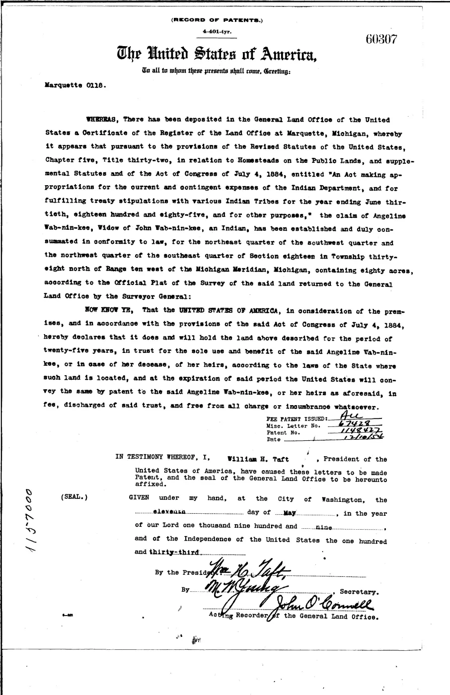
The strongest contemporary evidence located so far is not a village census or map but a cluster of federal Indian trust patents. In 1908–1909 the General Land Office recorded holdings in west-side Sections 18 and 19 for Tuhuais Bird, Simon Shaw-on-i-bi-acy, Angeline Wab-nin-kee, and John Wa-buash-cung. Angeline’s patent identifies her as the widow of John Wab-nin-kee. These records support a Native landholding community in the right broad area and period, but they do not name Peshawbe’s Town or establish its boundary.
A 2012 Beaver Beacon history says families from north of Suttons Bay built homes below Angeline’s Bluff and cut timber for the Beaver Island Lumber Company. The 2024 township recreation plan gives the more precise claim that a Grand Traverse Bay Band group founded Peshawbestown in 1905. Because that plan does not cite an underlying record, circa 1905 is retained as a qualified date rather than an exact founding year.
An April 1905 newspaper item, preserved in a 2005 Beacon reprint, reports that a lumber-company employee printed as “John Wabininsky (sic)” died after a falling limb fractured his skull in the woods. The name resembles John Wab-nin-kee, whose widow Angeline received the 1909 patent, but no held record yet proves they were the same man. It is a closely similar surname in the company’s woods and a kinship lead, not a resolved identification.
Language and location limits
The Historical Map’s phrase “settlement of Indians” is transcribed in the source ledger but not adopted as the KB’s narrative voice. The community is described as Anishinaabe, with Odawa or Chippewa affiliation stated only where an inspected source does so. Exact archaeological locations, burials, and artifact findspots are intentionally omitted. The map and later plan locate the community only approximately; neither is a surveyed settlement plan.
Open questions
- Do the federal allotment or homestead case files name relatives, witnesses, prior residences, or a local settlement?
- Does a Grand Traverse Band archive, agency census, lumber-company payroll, church register, or school record use Peshawbe’s Town by name?
- When did residents arrive, and how long did the settlement retain a distinct community identity?
See also
Maps for this place
These Atlas plates provide regional context. They do not establish a precise boundary, current ownership, access right, operating status, or field condition.
- EnvironmentSoils, wetlands, hydrography, and terrain
- GeologyGeneralized geology and landforms
- HydrologyMapped water and wetland context
- AccessMapped routes, facilities, and protected areas
- Land surveyPLSS geometry and historic GLO patent-location context
The page
Rendered from the held scan.
Sources
- Primary federal index records Indian trust holdings in T38N R10W Sections 18–19 for Tuhuais Bird, Simon Shaw-on-i-bi-acy, Angeline Wab-nin-kee, and John Wa-buash-cung. The clustered records corroborate Native landholding in the map’s broad settlement area but do not name Peshawbe’s Town, establish 1905, or define a village boundary. The holder's public portal is searchable but does not link this record directly; the archive holds a copy of the file and can provide it on request.federal · glo · beaver_island_patent_locations
- Primary patent identifies Angeline as an Indian widow of John Wab-nin-kee and records her 80-acre Section 18 trust holding. The holder's public portal is searchable but does not link this record directly; the archive holds a copy of the file and can provide it on request.federal · glo · patents · 17113869873279326119-patent-ser-60307
- Described in this archive: Beaver Island History Map, 1978 revision.Labels “Peshawbe’s Town” and describes it, in the map’s dated terminology, as “a settlement of Indians from Grand Traverse Bay.” It supplies an approximate cartographic association, not a surveyed site or primary migration record.
- *Beaver Beacon*, January 2012, Beaver Island Lumber Company history.Retrospective article says a group from north of Suttons Bay built homes below Angeline’s Bluff, cut logs above it, and supplied timber to the lumber-company system. It does not use the settlement name or give an arrival year. No public copy of this file is known; the archive holds one and can provide it on request.data1 · beaver-island-archive · beaver_beacon · 2012-01_Beaver-Beacon
- Says a group from the Grand Traverse Bay Band settled below Angeline’s Bluff in 1905 and named the village Peshawbestown. The plan gives no citation, so the date, self-naming, and precise origin remain retrospective claims.planning · beaver_island_master_plan · 2024-2028-beaver-island-recreation-plan-fa1f69af
Added 7 August 2026. Recent changes
Cite this article
Beaver Island Archive, “Peshawbe’s Town (Beaver Island)”, https://beaverislandarchive.org/places/peshawbes-town/, accessed [date], citing U.S. General Land Office and Bureau of Indian Affairs, west-side Indian trust patents, 1908–1909. (and 4 further sources listed on the page).
Last revised 2026-08-07. Fill in [date] with the date you read it — this page is static and cannot know that.
BibTeX for “Peshawbe’s Town (Beaver Island)”RIS for “Peshawbe’s Town (Beaver Island)”