

- Along road
- Barney's Lake Road South · McCauley's Point Road · Protar's Tomb Road
- Coordinates
- 45.7207° N, 85.5686° WGoogle Maps: Kuebler TrailDownload KML
- Eras
- Modern era
- Concepts
- trailstransportationrecreationconservationraillumberingheritagetoponymy
- Within
- Beaver Island
- Media
- Beaver Island History Map, 1978 revision
Summary
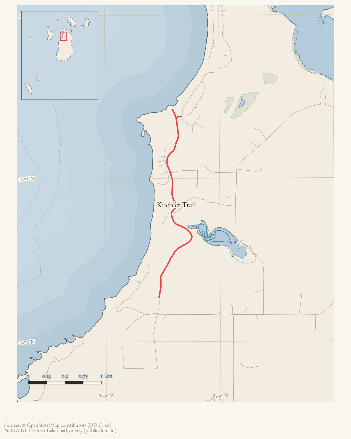
Kuebler Trail is a named, unpaved recreational trail in the south-central Beaver Island woods. A January 1971 Beaver Beacon item identifies the old railroad right-of-way through Paradise Valley that Karl Kuebler had brushed out in fall 1970 and thanks him for “Kuebler Trail.” Local accounts connect its northern end with McCauley’s Point and its drivable end with the engineer’s memorial and Protar’s Tomb; Little Traverse Conservancy identifies a half-mile segment within Barney’s Lake Nature Preserve. Current OSM data contains seventeen named trail segments, which are mapped here as an approximate route rather than a claim that every branch or right-of-way is known.
The route
Published and mapped. Peaine Township’s own trail guide gives a
turn-by-turn description running north from the trail gate at
Protar’s Tomb, titled “Protar’s Tomb to McCauley
Point Access”: 1.81 miles to a T junction, then 0.04 mile west to Lake
Michigan at McCauley Point or 0.04 mile east to Allen’s Lakeview Road. The
2023-24 draft recreation plan gives a different figure for the whole
route — 4 miles — which likely counts branches and the Barney’s Lake
connector the point-to-point description does not. OpenStreetMap separately
carries seventeen named “The Kuebler Trail” ways, mapped here as an
approximate route (geometry_status: approximate). No GPS ground truth is
held for this trail; the archive’s walked tracks cover the south end only.
Points of interest
Following the township guide north from Protar’s Tomb: the trail passes the west end of Barney’s Lake at 0.66 mile, visible to the east with footpaths to the shore; meets a Little Traverse Conservancy connecting trail from Barney’s Lake Road at 0.86-0.90 mile, which itself crosses Deerwood Road; crosses the paved Deerwood road directly at 0.90 mile; passes through a six-foot culvert under Eagle Bay Road at 1.27 mile; and runs beneath Angeline’s Bluff for its final 0.54 mile to the McCauley Point/Allen’s Lakeview Road junction. The guide calls it “a gentle and easy trail.”
Natural history
The trail’s north end opens onto the McCauley Point open dunes, surveyed by the Michigan Natural Features Inventory in 2017 as a 30-acre element occurrence. Pitcher’s thistle (Cirsium pitcheri), state and federally threatened, is among the dominant ground cover of the parabolic dune and foredune there.
What the route was
The 1978 Historical Map describes Kuebler’s Trail as the “last intact stretch” of the railroad grade and dates its conversion to a walking trail to 1972. The contemporary January 1971 report is decisive against that date: islanders were already using the named trail after Kuebler cleared it the preceding fall. A July 2002 Beacon property description independently calls it the old Beaver Island Lumber Company railroad-grade walking trail and describes a route between Donegal Bay and Protar’s Tomb. Neither item proves that the whole current trail follows the grade, or that it was literally the last intact surviving stretch.
Access and ownership
Ownership is mixed and, in one stretch, disputed. The township’s own 2023-24 draft recreation plan records Kuebler Trail as “private ownership and Little Traverse Conservancy,” reached from Allen’s Lakeview Road and Sloptown Road, and marks it “Public for hiking” — a township characterization, not a title record. The Conservancy’s own Barney’s Lake Nature Preserve page independently confirms a half-mile segment crosses its preserve.
In May 2013, on the Port of St. James Association’s own forum thread, a resident wrote that most of Kuebler Trail crosses Bonner’s Landing or Deerwood private land and that “hikers and non-powered bikers are VERY welcome.” PSJA president Kirk D. McBride replied the same week that a portion of the trail has been part of PSJA Common Property since its beginning, that the association had never turned anyone away, but that publishing a map showing the route crossing that property without inviting PSJA into the planning process created a liability exposure to PSJA’s then-500-plus members; he asked that further publishing and distribution of the map be curtailed until PSJA was consulted. Both statements are dated positions from May 2013, not a present guarantee of access and not a deed, easement or court determination either way.
No source held here documents a motorized designation. There are no designated public ORV trails on Beaver Island. Trail conditions change: the trail association’s own sheets warn that island trails “can become overgrown and unrecognizable in many areas,” and nothing here should be used for navigation.
Evidence and limits
The road and trail associations are assembled from the Conservancy’s access directions, a local geographic account, the Protar historic-site description, and current volunteered mapping. The 2013 forum dispute adds an important access warning: mapped continuity is not proof of public access or an easement, particularly across property associated with the Port of St. James Association. A field survey, title/easement research, and a single authoritative route map would be needed to replace the approximate segments. The held sources also do not establish whether Kuebler created a new footpath, reopened an already familiar route for snowmobiles, or cleared only part of the former right-of-way; “brushed out” is the contemporary wording.
Open questions
- Where exactly does PSJA Common Property begin and end along the trail? The 2013 forum exchange asserts it without a plat or legal description, and none has been located.
- Does a copy of the 2013 trail map that prompted the PSJA objection survive in the archive? It is discussed but not itself held.
- Does the 4-mile figure in the 2023-24 recreation plan include the Barney’s Lake connector and other branches the 1.81-mile Protar’s-Tomb-to-McCauley- Point description does not, or does it measure something else?
- Did Kuebler create a new footpath in 1970, reopen a route already used for snowmobiling, or clear only part of the former railroad right-of-way? The contemporary account says only “brushed out.”
If you can answer any of these, or correct anything above, the archive wants to hear it — see Corrections.
See also
Documented associations
No source-confirmed non-road entity is linked yet. Exact-name research leads remain in scripts/audit_road_links.py; a name collision is not treated as a road association.
Research status
The local newspaper and website corpus contains exact-name mentions in 0 file(s). Those files are research leads; the relation layer is added only when the surrounding source text establishes that the record involves this road.
Maps for this place
These Atlas plates provide regional context. They do not establish a precise boundary, current ownership, access right, operating status, or field condition.
- EnvironmentSoils, wetlands, hydrography, and terrain
- GeologyGeneralized geology and landforms
- HydrologyMapped water and wetland context
- AccessMapped routes, facilities, and protected areas
- Land surveyPLSS geometry and historic GLO patent-location context
Sources
- Contemporary item says snowmobilers used the old railroad right-of-way that Karl Kuebler had brushed out “this past fall,” thanks him for “Kuebler Trail through Paradise Valley,” and notes he did the work after a severe heart attack the previous winter. It dates the named trail to fall 1970, two years earlier than the 1978 map’s 1972 date.data1 · beaver-island-archive · beaver_beacon · 1971-01_Beaver-Beacon
- Calls Kuebler Trail the old Beaver Island Lumber Company railroad-grade walking trail and describes it as crossing the advertised parcel, with a walk between Donegal Bay and Protar’s Tomb. This is later local-use evidence, not a route survey or proof that the entire surviving grade was intact. The holding institution's portal restricts automated access; the archive holds a copy of this issue and can provide it on request.data1 · beaver-island-archive · beaver_beacon · 2002-07_Beaver-Beacon
- Described in this archive: Beaver Island History Map, 1978 revision.Calls it the last intact stretch of railroad grade and says Karl Kuebler made it a walking trail in 1972. The contemporary January 1971 Beacon disproves the 1972 date; no source located establishes the “last intact” superlative.
- The preserve page says a half-mile of Kuebler Trail crosses the preserve and gives access from Barney’s Lake Road South. It describes the trail in a current stewardship context, not as a surveyed complete route.
- The local account identifies an access path at McCauley’s Point leading to the north end of Kuebler Trail. It is descriptive and does not establish a legal trail boundary.
- The historic-site account places Protar’s Tomb past the engineer’s grave at the end of the drivable portion of Kuebler Trail, supporting the Protar’s Tomb Road association.
- Seventeen current unpaved trail ways carry the name “The Kuebler Trail.” Their volunteered geometry is represented as approximate route segments, not a surveyed continuous line.osm · trails
- A Port of St. James Association president objected that a published trail map appeared to cross PSJA common property without notice and could imply public access, raising liability and fiduciary concerns. Another participant described the trail as welcome to hikers and non-powered bicyclists. These are competing community/legal positions, not a deed, easement, court ruling, or surveyed public-access determination.forum · www.beaverislandforum.com · 06 · t006221
- Pages 4-5, ‘Kuebler Trail: Protar’s Tomb to McCauley Point Access’, give a turn-by-turn published route: from the trail gate at Protar’s Tomb, 1.81 miles north to a T junction, then 0.04 mile to Lake Michigan/McCauley Point or 0.04 mile to Allen’s Lakeview Road. It passes the west end of Barney’s Lake at 0.66 mile, meets a Little Traverse Conservancy connecting trail from Barney’s Lake Road at 0.86-0.90 mile, crosses the paved Deerwood road at 0.90 mile, passes through a 6-foot culvert under Eagle Bay Road at 1.27 mile, and runs beneath Angeline’s Bluff for the final 0.54 mile. Calls it ‘the narrow gauge railroad bed that once hauled Beaver Island lumber’ and ‘a gentle and easy trail.’governance · peaine · trails · all-trail-descriptions
- Recreation-site table lists Kuebler Trail as 4 miles of trail on the old narrow-gauge railroad bed, accessed from Allen’s Lakeview Road and Sloptown Road, under private ownership and Little Traverse Conservancy, and ‘Public for hiking.’ This is the pre-adoption draft; the adopted plan is dated 4 January 2024.governance · peaine · trails · peaine-park-and-rec-plan-draft-2023-11-27
- Surveys a 30-acre open-dunes element occurrence at McCauley Point (element occurrence rank C, surveyed 2016), the trail’s northern end, listing Pitcher’s thistle (Cirsium pitcheri, state and federally threatened) among the dominant ground cover of the parabolic dune and foredune.research · island_farming · mnfi_natural_community_surveys_beaver_archipelago_2017_11
Added 2 August 2026 · revised 16 August 2026. Recent changes
Cite this article
Beaver Island Archive, “Kuebler Trail”, https://beaverislandarchive.org/places/kuebler-trail/, accessed [date], citing *Beaver Beacon*, January 1971, “Beaver Tales.” (and 10 further sources listed on the page).
Last revised 2026-08-16. Fill in [date] with the date you read it — this page is static and cannot know that.