

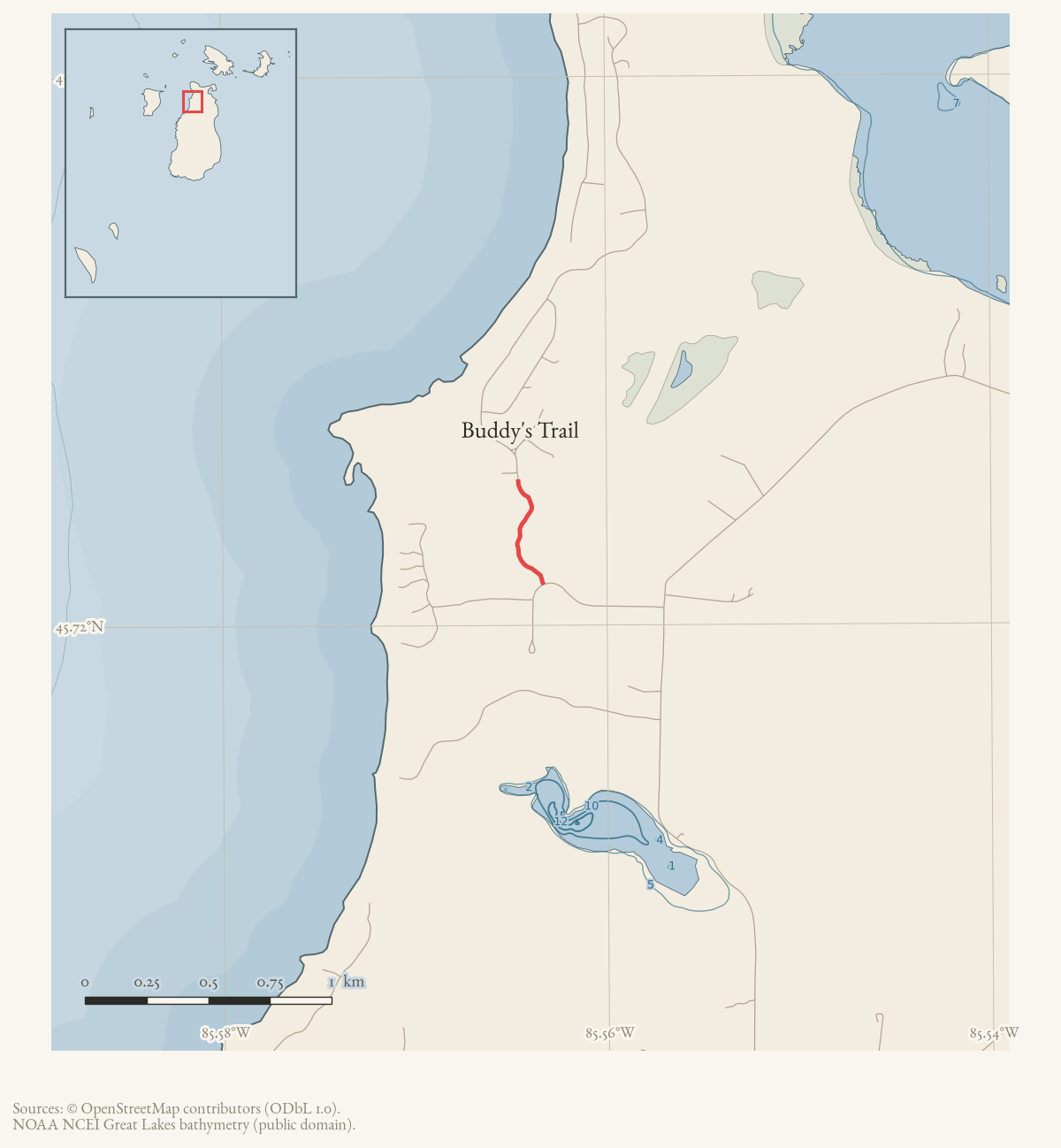
- Along road
- Allen's Lakeview Road · Eagle Hill Road
- Coordinates
- 45.7233° N, 85.5645° WGoogle Maps: Buddy's TrailDownload KML
- Eras
- Modern era
- Concepts
- trailstransportationrecreationemergency-managementtoponymy
- Within
- Beaver Island
Summary
Buddy’s Trail is not a maintained hiking trail. It functions as a private or lightly-used access road that the joint township planning commission has twice identified, four years apart, as the fallback route when South End Road cannot be used — most concretely during the emergency conditions the commission discussed in January 2023. Current OpenStreetMap data supplies a named unpaved line meeting Allen’s Lakeview Road and Eagle Hill Road, but no source in the archive describes who owns or maintains it.
Access and ownership
Nothing in the archive establishes public access to Buddy’s Trail as a matter of right. What is documented is narrower and more specific:
- The January 16, 2023 Beaver Island Joint Peaine & St. James Townships Planning Commission minutes name Buddy’s Trail as the only remaining alternative route during South End Road emergency issues — implying it was already relied on informally for that purpose, without describing who authorized it or maintains it.
- The Peaine Township Planning Commission’s January 2025 Capital Improvement Plan priority list keeps “Roads – Emergency Road Access, Buddy Martin’s Trail” as its own funded-improvement line item, distinct from the township’s list of walking trails, which confirms the township’s continuing interest in the route specifically as emergency road infrastructure.
Both records describe township interest in the route, not a settled ownership or maintenance arrangement, and neither states whether the general public may use it outside an emergency. Given that ambiguity, this trail should be treated as a private or quasi-private access way that the townships have discussed relying on, not as an open public trail.
Evidence and limits
Published: named in two sets of township planning-commission minutes,
2023 and 2025, both concerning emergency road access rather than recreation.
Mapped: one current OpenStreetMap way (227202517), tagged as an unpaved
named trail, geometry_status: mapped; this is volunteered geometry, not a
surveyed right-of-way. Walked: not documented in this archive. The
planning record never describes the trail’s full alignment, condition, or
who maintains it — only that township officials have twice discussed relying
on it.
Open questions
- Who owns the land Buddy’s Trail crosses, and on what basis have the townships treated it as an available emergency route?
- Is “Buddy Martin’s Trail,” the name used in the 2025 Capital Improvement Plan, the same road as the 2010 forum report of “Buddy Martin’s Trail” closed by a down tree — or does that report instead describe Johnny Martin’s Trail? The two are documented separately in current township records but share a family name.
- Has Buddy’s Trail ever actually been used as a South End Road detour, or has it remained a contingency identified in planning discussions only?
If you can answer any of these, or correct anything above, the archive wants to hear it — see Corrections.
See also
Documented associations
No source-confirmed non-road entity is linked yet. Exact-name research leads remain in scripts/audit_road_links.py; a name collision is not treated as a road association.
Research status
The local newspaper and website corpus contains exact-name mentions in 0 file(s). Those files are research leads; the relation layer is added only when the surrounding source text establishes that the record involves this road.
Maps for this place
These Atlas plates provide regional context. They do not establish a precise boundary, current ownership, access right, operating status, or field condition.
- EnvironmentSoils, wetlands, hydrography, and terrain
- GeologyGeneralized geology and landforms
- HydrologyMapped water and wetland context
- AccessMapped routes, facilities, and protected areas
- Land surveyPLSS geometry and historic GLO patent-location context
Sources
- The minutes identify Buddy’s Trail as the remaining alternative route during South End Road emergency issues. They do not define the trail’s full alignment.planning · beaver_island_master_plan · january-16-2023-master-plan-joint-commission-20726379
- Way 227202517 is tagged as an unpaved named trail. Its direct intersections with Allen’s Lakeview Road and Eagle Hill Road support the road links; the volunteered line is not a surveyed right-of-way.osm · trails
- Peaine Township Planning Commission, regular meeting minutes, 3 January 2025.The 2025-2026 Capital Improvement Plan priority list carries 'Roads - Emergency Road Access, Buddy Martin's Trail' as its own line item, separate from item (e), All Trails, which lists Johnny Martin's Trail. Confirms the township continues to treat this as a road matter, specifically for emergency access, in 2025.governance · township_meetings · peaine-planning · 01-03-2025-planning-commission-regular-meeting-minutes-approved-c9cdd40cd5
- A forum notice under the title 'Buddy Martin's Trail' reported that a trail called 'Martin's Trail' was closed by a down tree. It is not established here whether this refers to Buddy's Trail or to the separately documented Johnny Martin's Trail; see Open questions.forum · www.beaverislandforum.com · 02 · t002576
Added 2 August 2026. Recent changes
Cite this article
Beaver Island Archive, “Buddy's Trail”, https://beaverislandarchive.org/places/buddys-trail/, accessed [date], citing Beaver Island Joint Peaine & St. James Townships Planning Commission, January 16, 2023 minutes. (and 3 further sources listed on the page).
Last revised 2026-08-02. Fill in [date] with the date you read it — this page is static and cannot know that.