

- Coordinates
- 45.6304° N, 85.5619° WGoogle Maps: Middie Perron’s TrailDownload KML
- Eras
- Modern era
- Concepts
- trailstransportationrecreationModern eratoponymy
- Within
- Beaver Island
- Media
- Beaver Island History Map, 1978 revision
Summary
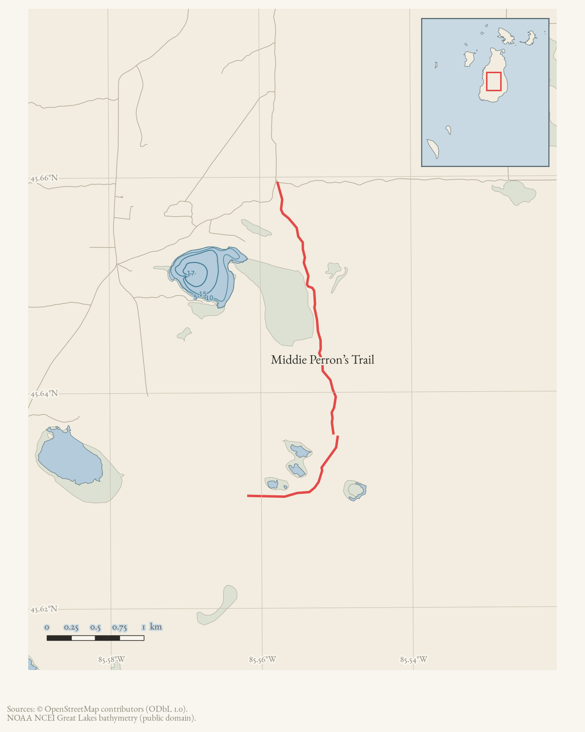
Middie Perron’s Trail (also written Middle Perron’s Trail) is a named route in the 2015 map, 2016 DNR report, and current OSM. Its map uses the two current OSM named segments. It is remembered in the 1995 Beaver Beacon for its apple trees and a vanished drive-through barn recalled as the island’s “only covered bridge.”
Official map: Middie Perron’s Trail (BITA, July 2019).
What the route was
The township’s own narrative guide calls Middie Perron’s Trail, Government Tower Trail, Camp #3 Trail and Greene’s Lake Road “former functional roads,” drivable in stretches with a high-clearance vehicle when dry, that “make great hiking and even better biking trails.” It runs south from the Fox Lake Road/Hannigan’s Road intersection as a two-track, meets Government Tower Trail at 1.73 miles, and “somewhere in the next 0.5 mile” the road becomes Johnny Martin’s Trail. Past that point it crosses swampy ground where logs have been laid across the track to allow ORV passage.
Points of interest
The 1995 Beacon trail-network inventory recalls the trail for its apple trees and a drive-through barn, since gone, that islander Bob Malloy remembered from a childhood buggy ride as the “Island’s only covered bridge.” No source in the archive gives the barn’s location or the date it disappeared.
Map status
Geometry is mapped from OSM retrieved 2026-08-02. Pending update: verify trail condition and alignment against a current official or field track.
Access and ownership
The trail is published and mapped but not documented as walked with GPS in this archive. BIATA’s own sheet carries the standing disclaimer:
“BIATA Trail Maps are not official DNR maps. They were prepared as an imperfect visual guide for the user and should not be relied upon for complete accuracy. Trails can become overgrown and unrecognizable in many areas.”
No source in the archive states who owns the ground the trail crosses. The 2019 township signage program and BITA’s 2019 trail sheet both describe routine maintenance and marking, not a legal right of way, and the trail’s 1990s-era description as a “functional road” — a former way for reaching property, not a purpose-built recreational path — matches the general pattern BIATA records for the island’s trail network.
As walked in 2019. a walked account contributed in 2019 puts the trailhead at the Fox Lake Road / Hannigan Road intersection and warns there is no parking at the trailhead, so a walker has to find a place off one of the two roads. It gives the trail as about 1.75 miles end to end, running to the Johnny Martin’s / Greene’s Lake trail.
That account spells the name Middle Perron’s. The trail association’s sheet and the township both use Middie. The variant is recorded here rather than corrected.
Evidence and limits
Published: named on the 2015 map, in the 2016 DNR trails report, in the
township’s narrative guide, and on BITA’s July 2019 sheet — the fullest
published record of any trail in this group. Mapped: two current OSM
named ways, geometry_status: mapped, though volunteered rather than
surveyed. Walked: not documented here; the archive holds no GPS track or
recent field account of trail condition, so whether the swampy stretch
described in the township guide is presently passable is unverified.
Open questions
- Where did the drive-through barn recalled in the 1995 Beacon stand, and when was it lost? No source gives a location or date.
- Is the trail presently passable through the swampy section where logs were laid for ORV crossing, and how far does the connection to Johnny Martin’s Trail actually run?
- Who was Middie (or Middle) Perron, and is either spelling the person’s own? No biographical source in the archive addresses the name.
If you can answer any of these, or correct anything above, the archive wants to hear it — see Corrections.
See also
Documented associations
No source-confirmed non-road entity is linked yet. Exact-name research leads remain in scripts/audit_road_links.py; a name collision is not treated as a road association.
Research status
The local newspaper and website corpus contains exact-name mentions in 0 file(s). Those files are research leads; the relation layer is added only when the surrounding source text establishes that the record involves this road.
Maps for this place
These Atlas plates provide regional context. They do not establish a precise boundary, current ownership, access right, operating status, or field condition.
- EnvironmentSoils, wetlands, hydrography, and terrain
- GeologyGeneralized geology and landforms
- HydrologyMapped water and wetland context
- AccessMapped routes, facilities, and protected areas
- Land surveyPLSS geometry and historic GLO patent-location context
Sources
- The legend prints Middie Perron’s Trail.
- Uses the variant “Middle Perron’s Trail” and discusses maintenance.
- Two current named ways (265420270 and 265422480), simplified for display.osm · trails
- Page 17 describes Middie Perron's Trail running south from the Fox Lake Road/Hannigan's Road intersection as a mostly good two-track with a few deep ruts and puddles, meeting Government Tower Trail at 1.73 miles and then, 'somewhere in the next 0.5 mile,' becoming Johnny Martin's Trail; at about 2.7 miles it crosses swampy ground where logs have been laid to allow ORV passage. Groups this trail with Government Tower, Camp #3 and Greene's Lake Road under the heading 'Middle Trails,' and says all four received new signs from the Trails Committee in 2019.governance · peaine · trails · all-trail-descriptions
- Starts the trail at Fox Lake Road and Hannigan's Road, calls the area a wilderness subject to impassable wet stretches, and gives approximate waypoint distances including 1.8 miles to where it meets Greene's/Martin Trail and a 5.3-mile loop combining Middie Perron's, the Government Tower section of Greene's/Martin Trail, Camp Three Trail and Fox Lake Road. Carries BIATA's standing disclaimer that its maps are not official DNR maps and trails can become overgrown and unrecognizable.governance · peaine · trails · bita-middie-perrons-trail-2019-07
- Beaver Beacon, October 1995.An island trail-network inventory names Middie Perron's Trail among 24 trails on the 1990 Wojan-Cashman map and recalls 'its apple trees and now-gone drive-through barn that Bob Malloy remembered from a childhood buggy ride as the "Island's only covered bridge."' A dated recollection, not a structure record; no other source in the archive corroborates the barn's location or date of loss.
- Kamrin, Michael. 'An Insiders Guide to Beaver Island Hiking Trails: A Companion to the Wojan/Cashman Beaver Island Map.' Unpublished typescript, created 8 August 2019, last revised 17 February 2020.Walked account. Places the trailhead at the intersection of Fox Lake Road and Hannigan Road with no parking there, so a walker must find a spot off either road, and gives the trail as about 1.75 miles end to end, finishing at the Johnny Martin's/Greene's Lake trail. SPELLS THE NAME 'Middle Perron's' — a variant of the form the trail association and the township use, recorded, not corrected.fieldwork · accounts · kamrin-insiders-guide-bi-hiking-trails
Added 2 August 2026. Recent changes
Cite this article
Beaver Island Archive, “Middie Perron’s Trail”, https://beaverislandarchive.org/places/middie-perrons-trail/, accessed [date], citing Beaver Island trails map, revised October 2015. (and 6 further sources listed on the page).
Last revised 2026-08-02. Fill in [date] with the date you read it — this page is static and cannot know that.
BibTeX for “Middie Perron’s Trail”RIS for “Middie Perron’s Trail”