

- Along road
- East Side Drive
- Coordinates
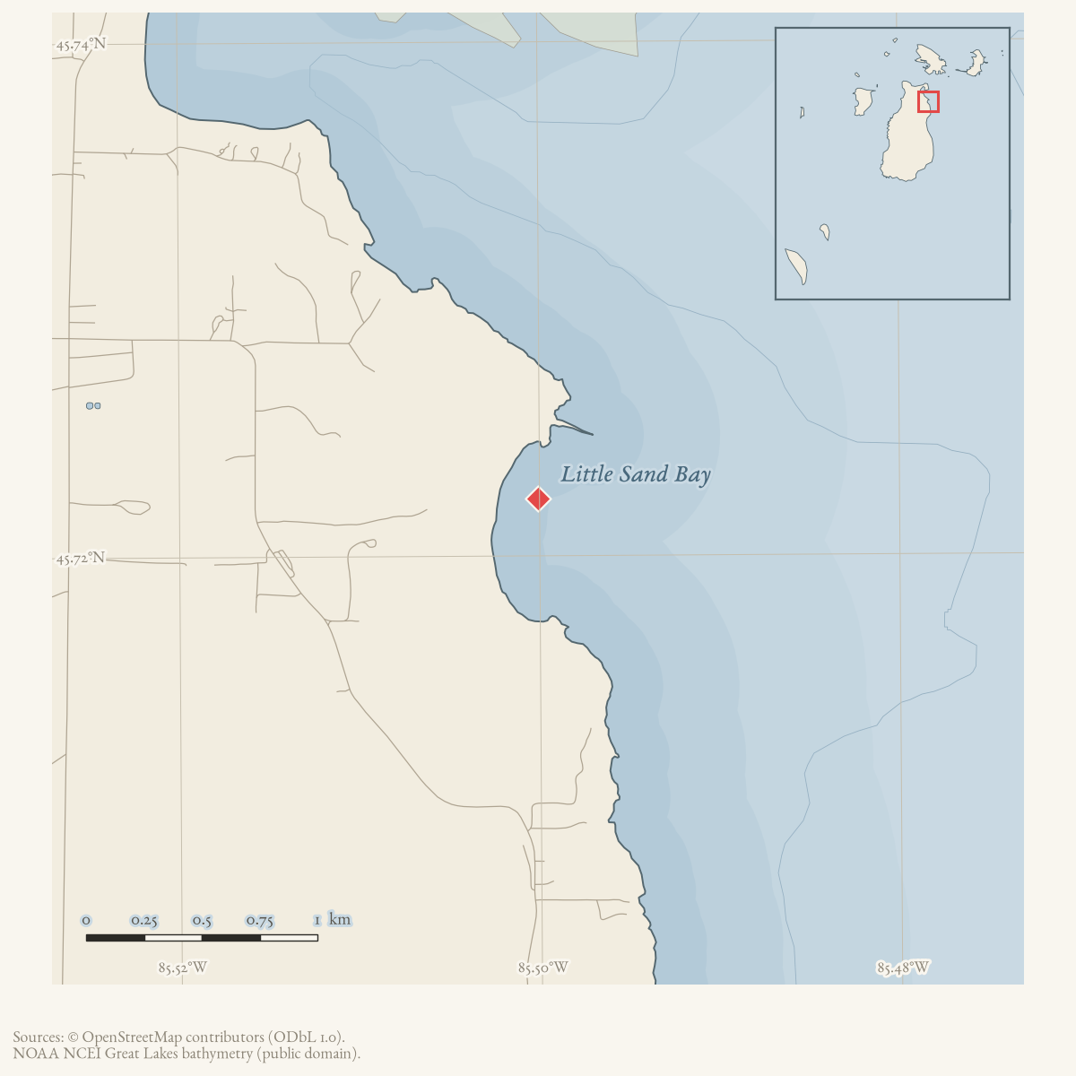
- 45.7222° N, 85.5001° WGoogle Maps: Little Sand BayDownload KML
- Eras
- Strang eraModern era
- Concepts
- toponymytourismenvironmentgeologysoilsforeststreesvegetationplantswetlandshydrologywildlifeanimalsconservationstewardshipinvasive-speciesrecreationmigration
- Within
- Beaver Island
- Media
- Beaver Island History Map, 1978 revision · Plat of Big Beaver Island, 1901 · Plat of the north end of Beaver Island, 1930s
Summary
Little Sand Bay is a bay on Beaver Island’s east side, GNIS feature 630757 at 45.722222° N, 85.500086° W.1 It is a distinct feature from Sand Bay (GNIS 637224), roughly 4.3 km to the south; sources sometimes call Sand Bay “Big Sand Bay” to keep the two apart, a colloquial usage attested from at least 1963, but that name belongs to Sand Bay and is not treated here as evidence about Little Sand Bay.2 Before it became a protected nature preserve, the Beacon records the place as private cabin country and a route landmark: the Grossi family’s cabin, noted in an August 1958 obituary as “the only cabin in Little Sand Bay,” a record-sized local coyote shot there in January 1963, and a car sliding off the road there in November 1971 en route to Lake Geneserath.345 From 1994 the bay became the site of a sustained community conservation campaign — the purchase and development of the Little Sand Bay Nature Preserve — and, from 2009 onward, of active archaeological and historic-structure questions about a Mormon-era log cabin on the preserve grounds.67
Names
GNIS records “Little Sandy Bay” as the sole variant of the current name,
kept here in alt_names as a spelling variant, not a former
name.8 No source read for this article gives an etymology for
“Little,” beyond the evident contrast with the larger Sand Bay to the south.
Early residency and recreational use
The earliest dated record of the bay as a place people lived, not merely passed through, is the Grossi family’s cabin, described in a September 1958 Beacon obituary notice as “the only cabin in Little Sand Bay” at the time of Bernadine Grossi’s death.3 Winter recreation is documented by January 1963, when a Coyote-hunting party from Indian River and Rogers City, joined by Islanders, shot a record-sized local coyote at Little Sand Bay.4 The area also appears as a route landmark rather than a destination in a November 1971 account of a car sliding off the road there while travelers made their way toward a Thanksgiving gathering at Lake Geneserath.5 A fifty-acre parcel on Little Sand Bay was separately advertised for sale in March 1993, the year before the conservation purchase below; no source held here ties that listing to the land the Conservancy later acquired.9
The 1994 nature preserve purchase
Islanders designated Little Sand Bay their top conservation priority on Beaver Island after the property came on the market around 1993, citing its proximity to Saint James and the north end’s general lack of public beach.6 By July 1994 the Little Traverse Conservancy had closed its purchase agreement with Peter and Delores Gallagher for 60 acres and 1,300 feet of Lake Michigan frontage, land the Conservancy’s executive director, Tom Bailey, said held one of only thirteen sites worldwide where the Michigan monkey flower grows — an attributed period claim, not independently verified here.6 The roughly $300,000 project had raised more than half its cost by mid-1994, including a $30,000 Frey Foundation grant, a $30,000 pledge from the Michigan Nature Conservancy, and a $5,000 gift from Mr. and Mrs. Ralph Graham; CMU Biological Station director Jim Gillingham called the property “one of the most diverse areas of natural habitat on the entire Island.”6 That September, Peaine Township voted to donate $5,000 toward the purchase conditional on a guarantee of free public access in perpetuity, and BIPOA separately gave $1,000 after discussion of the project’s broad public benefit; a 2004 retrospective recalls that BIPOA member Fred Haubold had at the time protested the townships’ use of public funds for the purchase, a dispute the Conservancy answered in writing.1011 A May 2004 Peaine Township proposal to trade abandonment of the Mike Boyle’s Beach Road for funds to improve Little Sand Bay’s own access road was not adopted.12
Stewardship, archaeology, and the Doney cabin
The preserve’s trails and the questions they raise have continued into the twenty-first century. CMU Biological Station director Jim Gillingham enlisted faculty and students to build the preserve’s first boardwalks and bridges; when beaver flooding later blocked the trails, his crew restored them, a project recalled in a May 2009 tribute after his death.13 Volunteers organized by the Little Traverse Conservancy rebuilt the access trail within about a week in September 2007, reopening it for late-season visitors with a request to leave room around the creek supporting the protected monkey flower population.14 The preserve has also carried a recurring CMU-staffed nature walk during island Museum Week.15
A 20-by-32-foot large-log structure on the preserve grounds, known successively as the Early Home and the Doney Home, is documented from 2009 as a preservation question: possibly Mormon-era, hidden under later siding, it was the subject of a Historical Society plan reported in October 2009 to deconstruct and move it to Heritage Park over an estimated five years, using community-service groups.16 A February 2010 follow-up describes the same structure — “the old 20’ x 32’ large-log Mormon cabin (which became the Early Home and the Doney Home) at Little Sand Bay” — with the Society weighing restoration in place, relocation to the Protar land or town, or dismantling for a Heritage Park exhibit; no source held here records which option was chosen.7 That same year, Notre Dame archaeologist Deborah Rotman was reported conducting an archaeological study at “the old Peter Doney home” on the preserve property, work that drew a visiting Irish-diaspora archaeologist, Stephen Brighton, to compare Beaver Island’s Irish settlement history with sites in Texas and Maryland.17 In the same August 2010 issue, MNFI biologist Phyllis Higman identified the invasive European swamp thistle near the end of the Little Sand Bay boardwalk, one location among several logged in a broader island survey.18 By January 2011, a Beacon real-estate description placed the Conservancy’s preserve “one mile north of the newly purchased land along the same stretch of shoreline” — evidence of a further parcel acquisition by that date, though no source held here gives its acreage or acquisition date.19
Ecological profile
The 2017 MNFI survey treats Little Sand Bay as a connected shoreline complex, not just a named water feature. Three adjacent natural-community occurrences occur along the northeastern Beaver Island shore: a 37-acre boreal forest (EO 2437, report p. 28), a 17-acre interdunal wetland (EO 6089, p. 67), and a 17-acre rich conifer swamp (EO 20692, p. 140). Their boundaries are difficult to map precisely because fine-scale soil and hydrology gradients overlap.
The boreal forest occupies rolling former sandy shoreline. A shallow acidic A horizon around pH 4.5 overlies slightly acidic to circumneutral sands around pH 6.5–7.0. Northern white-cedar dominates, with paper birch, balsam poplar, trembling aspen, red maple, hemlock, and red oak. A 31-centimeter cedar was estimated at 145 years old. Windthrow and blowdown produce coarse woody debris; beaver flooding has killed cedars in a narrow forested swale to the east, while deer browse and past logging also shape the structure. The ground layer includes starflower, Canada mayflower, twinflower, wild sarsaparilla, sedge, goldthread, bracken fern, and stiff clubmoss.
The adjacent sandy bay supports the interdunal wetland and a low foredune. The wetland’s sands are wet and alkaline around pH 8.0, with nearshore swales about 10–20 cm deep. Some swales appear to have formed within the previous decade of the survey; high Great Lakes water levels or storms can partly or completely bury the closest swale in sand. Stunted cedar, paper birch, balsam poplar, tamarack, and white pine occur along the margins. Kalm’s lobelia, grass-of-Parnassus, Ohio and grass-leaved goldenrods, silverweed, false asphodel, slender bog arrow-grass, and state-special-concern butterwort occur in the wetland. Adjacent foredune vegetation includes marram grass, sand reed grass, wormwood, white camas, Pitcher’s thistle, and Lake Huron tansy.
Inland, the rich conifer swamp has shallow 20–50-centimeter peats around pH 6.8–7.0 over circumneutral sands around pH 7.0. Northern white-cedar dominates with paper birch, red maple, white spruce, and tamarack; a 42-centimeter cedar was estimated at 135 years old. Beaver flooding has killed cedars in a narrow swale, and deer browse, cut stumps, blowdown, and windthrow document interacting wildlife and disturbance processes. The ground layer includes twinflower, starflower, bunchberry, sedges, ferns, skunk-cabbage, Canada mayflower, Jack-in-the-pulpit, wild blue flag, and other wet-forest plants.
MNFI recommends allowing natural processes, retaining buffers, and monitoring invasive plants and deer browse. These are source-bounded observations from three adjacent occurrences, not a current shoreline or wetland delineation, legal boundary, complete wildlife inventory, or present-condition survey.
Significance
Little Sand Bay’s record runs from a single private cabin in 1958 to the island’s clearest documented case of grassroots land conservation: a resident-led fundraising campaign that purchased and protected a globally rare plant habitat within a single year, followed by two more decades of volunteer trail-building, invasive-species monitoring, and unresolved questions about a Mormon-era structure on the property. That arc — private use, community acquisition, ongoing stewardship — distinguishes it from French Bay’s more isolated record and from Cable Bay’s continuous but privately developed shoreline.
Open questions
- What road, landing, or shoreline features historically defined Little Sand Bay before the 1994 preserve purchase?
- Can the relationship between Little Sand Bay and the Lake Geneserath route be mapped from contemporary roads or land records?
- What became of the “old 20’ x 32’ large-log Mormon cabin” (the Early Home / Doney Home): was it restored in place, relocated, or dismantled, and what did Deborah Rotman’s archaeological study find?
- Does the 1993 fifty-acre Little Sand Bay real-estate listing correspond to the parcel the Little Traverse Conservancy purchased in 1994, a different parcel, or the 2011 additional acquisition?
- What is the acreage and acquisition date of the parcel described in 2011 as lying a mile north of the original preserve?
- Was the Michigan monkey flower “thirteen sites worldwide” claim, attributed to the Conservancy’s 1994 director, ever independently verified by a botanical survey?
If you can answer any of these, or correct anything above, the archive wants to hear it — see Corrections.
See also
Footnotes
-
U.S. Geological Survey, Geographic Names Information System, Domestic Names (Michigan), retrieved 2026-07-28 (
data/federal/gnis/gnis_names.geojson), feature 630757. ↩ -
Beaver Beacon, September 1963, “Canvas City News,” and later classified and reminiscence notices, all describing Sand Bay (GNIS 637224) as “Big Sand Bay.” ↩
-
Beaver Beacon, July 1994, “Little Sand Bay Project.” ↩ ↩2 ↩3 ↩4
-
USGS GNIS, All Names (national) (
data/federal/gnis/gnis_variant_names.csv); “Little Sandy Bay” is the sole variant recorded for feature 630757. ↩ -
Beaver Beacon, March 1993, classified notice. ↩
-
Beaver Beacon, September 1994, Peaine Township minutes. ↩
-
Beaver Beacon, October 2004, “On This Date,” “Ten Years Ago,” recalling October 1994. ↩
-
Beaver Beacon, May 2004, Peaine Township minutes. ↩
-
Beaver Beacon, May 2009, tribute to Jim Gillingham. ↩
-
Beaver Beacon, September 2007, “Little Sand Bay Trail Improvements Complete.” ↩
-
Beaver Beacon, July 2010, “Nature Walks” schedule. ↩
-
Beaver Beacon, October 2009, “Beaver Island Historical Society” report. ↩
-
Beaver Beacon, August 2010, CMU lecture coverage. ↩
-
Beaver Beacon, August 2010, “Invasive Species” report. ↩
-
Beaver Beacon, January 2011, real-estate listing. ↩
Maps for this place
These Atlas plates provide regional context. They do not establish a precise boundary, current ownership, access right, operating status, or field condition.
- EnvironmentSoils, wetlands, hydrography, and terrain
- GeologyGeneralized geology and landforms
- HydrologyMapped water and wetland context
- AccessMapped routes, facilities, and protected areas
- Land surveyPLSS geometry and historic GLO patent-location context
The dated record
Sources
- GNIS feature 630757; feature class 'Bay'.federal · gnis · gnis_names
- Variant names: Little Sandy Bay.federal · gnis · gnis_variant_names
- Reports that a record-sized local coyote was shot at Little Sand Bay during a winter hunt.data1 · beaver-island-archive · beaver_beacon · 1963-01_Beaver-Beacon
- The held five-page issue scan is paired with the OCR source and confirms the published notice or report; it does not expand the source-specific identity, event, or outcome claims.data1 · beaver-island-archive · scans · beaver_beacon · issues · 1963-01_Beaver-Beacon
- Describes travelers sliding off the road at Little Sand Bay while traveling toward Lake Geneserath for Thanksgiving.data1 · beaver-island-archive · beaver_beacon · 1971-11_Beaver-Beacon
- The held ten-page issue scan is paired with the OCR source and confirms the published notice or report; it does not expand the source-specific identity, event, or outcome claims.data1 · beaver-island-archive · scans · beaver_beacon · issues · 1971-11_Beaver-Beacon
- The inventory lists Little Sand Bay off East Side Drive, with a public parking lot, trail, boardwalk, beach frontage, and bench. It does not establish a surveyed access easement, parcel boundary, or current condition.planning · beaver_island_master_plan · 2017-beaver-island-resilient-master-plan-8cbeebcd
- Project-generated MNFI 2017 soil, vegetation, and wildlife crosswalk, preserving MNFI Report 2017-11, Little Sand Bay boreal forest, interdunal wetland, and rich conifer swamp occurrences, report pp. 28, 67, and 140.Described in this archive: MNFI soil, vegetation, tree, and wildlife crosswalk, 2017.The three records describe adjacent natural-community occurrences along the northeastern Beaver Island shoreline, not a surveyed boundary for Little Sand Bay or the nearby preserve. No public copy of this file is known; the archive holds one and can provide it on request.research · island_farming · crosswalks · mnfi_soil_vegetation_wildlife_crosswalk
- Visual page evidence held with provenance sidecar; the image anchors the occurrence description and does not establish modern geometry or current condition.research · island_farming · evidence · mnfi-report-2017-11-page-0028-little-sand-bay-boreal-forest
- Visual page evidence held with provenance sidecar; the image anchors the occurrence description and does not establish modern geometry or current condition.research · island_farming · evidence · mnfi-report-2017-11-page-0067-little-sand-bay-interdunal-wetland
- Visual page evidence held with provenance sidecar; the image anchors the occurrence description and does not establish modern geometry or current condition.research · island_farming · evidence · mnfi-report-2017-11-page-0140-little-sand-bay-rich-conifer-swamp
- Records the death of Bernadine Grossi of Chicago Heights on August 10, 1958, and describes the Grossi family as owning "the only cabin in Little Sand Bay" -- the earliest dated residency record found here, predating the Little Traverse Conservancy preserve by 36 years. The holding institution's portal restricts automated access; the archive holds a copy of this issue and can provide it on request.data1 · beaver-island-archive · beaver_beacon · 1958-09_Beaver-Beacon
- Read directly. Reports the Little Traverse Conservancy closing its purchase agreement with Peter and Delores Gallagher for 60 acres and 1,300 feet of Lake Michigan frontage at Little Sand Bay, one of thirteen sites worldwide where the Michigan monkey flower grows (per Conservancy Executive Director Tom Bailey, an attributed claim, not independently verified here); a roughly $300,000 project with over $150,000 raised by mid-1994, including a $30,000 Frey Foundation grant, a $30,000 Michigan Nature Conservancy pledge, and a $5,000 gift from Mr. and Mrs. Ralph Graham. Quotes CMU Biological Station director Jim Gillingham calling the property "one of the most diverse areas of natural habitat on the entire Island." The holding institution's portal restricts automated access; the archive holds a copy of this issue and can provide it on request.data1 · beaver-island-archive · beaver_beacon · 1994-07_Beaver-Beacon
- Records Peaine Township's motion to donate $5,000 to the Little Traverse Conservancy for the Little Sand Bay purchase, conditional on a letter guaranteeing township residents free access in perpetuity, and BIPOA's separate $1,000 donation after discussion of the project's broad public benefit. The holding institution's portal restricts automated access; the archive holds a copy of this issue and can provide it on request.data1 · beaver-island-archive · beaver_beacon · 1994-09_Beaver-Beacon
- Beaver Beacon, October 2004, "On This Date," "Ten Years Ago."A retrospective recalling October 1994 township minutes in which Fred Haubold protested, on behalf of BIPOA, the townships' decision to contribute public funds to the Little Traverse Conservancy's Little Sand Bay purchase; the Conservancy submitted a letter defending the donation. Dated evidence of local political friction over the 1994 purchase, not a separate later acquisition. No public copy of this file is known; the archive holds one and can provide it on request.data1 · beaver-island-archive · beaver_beacon · 2004-10_Beaver-Beacon
- Beaver Beacon, May 2004, Peaine Township minutes.Records a proposal, not adopted, to trade abandonment of the Mike Boyle's Beach Road extension for funds to upgrade access to Little Sand Bay. No public copy of this file is known; the archive holds one and can provide it on request.data1 · beaver-island-archive · beaver_beacon · 2004-05_Beaver-Beacon
- Beaver Beacon, September 2007, "Little Sand Bay Trail Improvements Complete."Reports Little Traverse Conservancy volunteers rebuilding the access trail to Little Sand Bay within about a week, reopening it for late-season visitors, with a request to keep clear space around the creek supporting the protected monkey flower. No public copy of this file is known; the archive holds one and can provide it on request.data1 · beaver-island-archive · beaver_beacon · 2007-09_Beaver-Beacon
- Beaver Beacon, May 2009, tribute to Jim Gillingham.Credits CMU Biological Station director Jim Gillingham with enlisting faculty and students to build the first boardwalks and bridges at Little Sand Bay, and with restoring the trails after beaver flooding blocked them. No public copy of this file is known; the archive holds one and can provide it on request.data1 · beaver-island-archive · beaver_beacon · 2009-05_Beaver-Beacon
- Beaver Beacon, October 2009, "Beaver Island Historical Society" report.Reports a plan to deconstruct and move an old, possibly Mormon-era log cabin hidden under later siding at the Little Sand Bay Nature Preserve, to be reassembled at Heritage Park over an estimated five years using community-service groups. No public copy of this file is known; the archive holds one and can provide it on request.data1 · beaver-island-archive · beaver_beacon · 2009-10_Beaver-Beacon
- Beaver Beacon, February 2010, "Acquires Land."Describes the same structure as "the old 20' x 32' large-log Mormon cabin (which became the Early Home and the Doney Home) at Little Sand Bay," with the Historical Society weighing restoration in place, relocation to the Protar land or town, or dismantling for a Heritage Park exhibit; no final disposition is recorded here. No public copy of this file is known; the archive holds one and can provide it on request.data1 · beaver-island-archive · beaver_beacon · 2010-02_Beaver-Beacon
- Beaver Beacon, August 2010, "Invasive Species" report and CMU lecture coverage.Read directly. Reports MNFI biologist Phyllis Higman identifying invasive European swamp thistle near the end of the Little Sand Bay boardwalk, one of several island locations logged in a broader survey; separately reports Notre Dame archaeologist Deborah Rotman conducting a study at "the old Peter Doney home on East Side Drive on the Little Traverse Conservancy's Little Sand Bay property," which drew visiting archaeologist Stephen Brighton to discuss comparative Irish-diaspora settlement research. No public copy of this file is known; the archive holds one and can provide it on request.data1 · beaver-island-archive · beaver_beacon · 2010-08_Beaver-Beacon
- Beaver Beacon, July 2010, "Nature Walks" schedule.Lists a CMU-staffed "treasures of Little Sand Bay" adult nature walk during 2010 Museum Week, meeting at the Little Sand Bay parking lot. No public copy of this file is known; the archive holds one and can provide it on request.data1 · beaver-island-archive · beaver_beacon · 2010-07_Beaver-Beacon
- Beaver Beacon, January 2011, real-estate listing.Describes the Little Traverse Conservancy's Little Sand Bay Preserve as "located one mile north of the newly purchased land along the same stretch of shoreline," evidence of a further, separately acquired parcel by 2011 without giving that parcel's own acquisition date or acreage. No public copy of this file is known; the archive holds one and can provide it on request.data1 · beaver-island-archive · beaver_beacon · 2011-01_Beaver-Beacon
Added 28 July 2026 · revised 4 August 2026. Recent changes
Cite this article
Beaver Island Archive, “Little Sand Bay”, https://beaverislandarchive.org/places/little-sand-bay/, accessed [date], citing U.S. Geological Survey, Geographic Names Information System, Domestic Names (Michigan), retrieved 2026-07-28. (and 22 further sources listed on the page).
Last revised 2026-08-04. Fill in [date] with the date you read it — this page is static and cannot know that.