

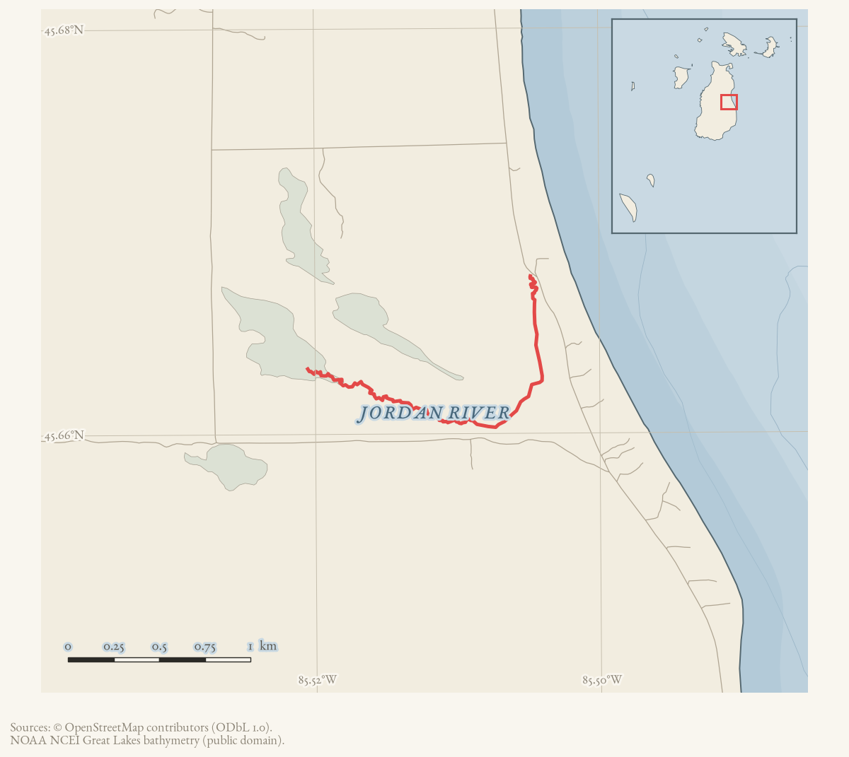
- Coordinates
- 45.6672° N, 85.5054° WGoogle Maps: Jordan RiverDownload KML
- Eras
- Strang eraModern era
- Concepts
- toponymyfishingwetlands
- Within
- Beaver Island
- Media
- Beaver Island History Map, 1978 revision · Plat of Big Beaver Island, 1901 · Plat of the north end of Beaver Island, 1930s
Summary
Jordan River is a GNIS-recorded stream in Beaver Island’s northern interior. The 2023 Beaver Island Master Plan places it within the Island’s connected inland-lake and stream network and identifies it as a designated trout stream. The plan characterizes it as a warm transitional stream with a robust community of minnows and shiners; it also records migratory runs of rainbow trout (steelhead), brown trout, white sucker, longnose sucker, and occasional Chinook and coho salmon.
The held hydrography crosswalk matches the GNIS identity to three NHD named segments totaling approximately 4.468 km and four OSM waterway features. The segments vary across sand and sandy-loam associations, riverine/emergent and forested/shrub wetland classes, and reconstructed beech–sugar maple–hemlock, mixed conifer swamp, and mixed hardwood swamp cover. This is useful physical context for the fish-passage narrative, not evidence of a single uniform river habitat or a complete current channel.
The name also appears in local land use. December 1961 and October 1963 Beaver Beacon reports refer to Jordan River Farms or the Jordan River Ranch and describe cattle operations there. Those reports establish the river name as a lived local reference, but they do not locate the ranch boundary or imply that the farms were on the stream itself.
The older “Jordan” name presents an identity problem, not merely an undated name. A 1912 newspaper feature says the Mormons called Lake Geneserath’s outlet the Jordan and placed Galilee at its mouth.1 The 1978 Historical Map, however, prints “Vesty’s River” beside the modern GNIS Jordan River farther north and ties it to Sylvester McDonough’s farm. Clementine McCauley’s family account does identify Sylvester as “Old Vesty” and says he built at Sand Bay, but it does not establish the stream alias or a farm date of 1863.2 Until historical channels are reconstructed, the lake outlet, Cable’s Creek, and modern GNIS Jordan River must not be silently collapsed into one feature.
Local use
The Beaver Beacon records the Jordan River as an annual spring smelt-dipping site across at least a decade of held issues. The May 1955 issue calls the Jordan River and Cable’s Creek the best dipping that year, after a smelt run that began April 21 and ran to about May 1; the May 1956, May 1957, May 1958, May 1961, and May 1962 issues each report island residents netting or dipping smelt there in similar terms, one describing dippers going without sleep and coming home “with wet feet and the sniffles” for buckets of the “silvery fish.” The recurrence across so many separate spring issues, rather than any single report, is the evidence for the river’s place in the island’s seasonal calendar.
Township records place a road culvert at the Jordan River under Charlevoix County Road Commission jurisdiction. Peaine Township board minutes from December 1983 record a motion to write the Road Commission asking why the culvert had not been installed; minutes from July 1984 note the “Jordan River Culvert” was still under discussion; and minutes from August 1986 record that Fred Welch would be on the island “to help with the completion of the Jordan River project,” in the same meeting as a road-improvement contract for Darkeytown Road. These records establish a multi-year road-crossing project at the river, without stating its final completion date.
In 1999 the Charlevoix County Land Conservancy created the Margaret P. Erber Nature Preserve, donated by Tom and Sue Erber of Charlevoix, at the river’s mouth on Little Sand Bay — see Charlevoix County Land Conservancy announces the Margaret P. Erber Nature Preserve on Beaver Island in 1999. This is the clearest held statement locating the modern GNIS river’s mouth.
Open questions
- Can the stream’s headwaters, mouth, and fish-passage connections be mapped against the Master Plan and current hydrology data?
- What is the source and date of the “Jordan” name, and does it relate to Strang’s biblical naming practice or an earlier local usage?
- What channel did Lake Geneserath drain through in 1851–56, and how does it compare with Cable’s Creek and the modern GNIS Jordan River?
- Where were Jordan River Farms and the Jordan River Ranch, and how did their land use affect the stream?
Footnotes
The dated record
Sources
- GNIS feature 629391; feature class 'Stream'.federal · gnis · gnis_names
- Lists the Jordan River among the Island’s principal fish-passage waterways and designated trout streams; describes it as a warm transitional stream with minnows, shiners, and migratory trout, sucker, and occasional salmon runs.
- Reports cattle brought to Jordan River Farms on Beaver Island and separately refers to the ranch pasture, documenting local use of the river name in a place-name.data1 · beaver-island-archive · beaver_beacon · 1961-12_Beaver-Beacon
- The held six-page issue scan is paired with the OCR source and confirms the published notice or report; it does not expand the source-specific identity, event, or outcome claims.data1 · beaver-island-archive · scans · beaver_beacon · issues · 1961-12_Beaver-Beacon
- Identifies the Jordan River Ranch and its owners during the annual movement of cattle from Beaver Island.data1 · beaver-island-archive · beaver_beacon · 1963-10_Beaver-Beacon
- The held six-page issue scan is paired with the OCR source and confirms the published notice or report; it does not expand the source-specific identity, event, or outcome claims.data1 · beaver-island-archive · scans · beaver_beacon · issues · 1963-10_Beaver-Beacon
- Project-generated named stream crosswalk (2026).Matches GNIS feature 629391 to three held NHD named flowline segments totaling approximately 4.468 km and four OSM waterway features; segment corridors show varied sand, wetland, and reconstructed forest/swamp context. These source geometries are not a legal or complete channel boundary. No public copy of this file is known; the archive holds one and can provide it on request.research · places · archipelago_stream_crosswalk
- Says the Mormons called Lake Geneserath's outlet the Jordan and placed Galilee at its mouth. It is evidence for the remembered toponymy in 1912, but it does not establish identity with the modern GNIS Jordan River farther north.federal · chronicling_america · sn92053934_1912-04-12_ed1_p12
- A family account identifies Sylvester McDonough as “Old Vesty” and says he built at Sand Bay. It does not call the modern stream Vesty's River or date his farm to 1863.
- Described in this archive: Beaver Island History Map, 1978 revision.Labels the modern Jordan River “Vesty's River” through Sylvester McDonough's 1863 farm. The nickname has independent support; the river alias, parcel, and date do not.
- Reports the smelt run began April 21 and ended about May 1, 1955, with the best dipping in the Jordan River and Cable's Creek.data1 · beaver-island-archive · beaver_beacon · 1955-05_Beaver-Beacon
- Reports smelt "surprisingly good for about a week in the Jordan River"; one of several held spring issues (1955-1964) reporting the same annual smelt run at the river. The holding institution's portal restricts automated access; the archive holds a copy of this issue and can provide it on request.data1 · beaver-island-archive · beaver_beacon · 1957-05_Beaver-Beacon
- Records a motion to write the Charlevoix County Road Commission asking why a culvert had not been installed at the Jordan River. The holding institution's portal restricts automated access; the archive holds a copy of this issue and can provide it on request.data1 · beaver-island-archive · beaver_beacon · 1983-12_Beaver-Beacon
- Records the Jordan River Culvert still under discussion, with Burris to contact Fred Welch. The holding institution's portal restricts automated access; the archive holds a copy of this issue and can provide it on request.data1 · beaver-island-archive · beaver_beacon · 1984-07_Beaver-Beacon
- Records Fred Welch coming to the island to help complete the "Jordan River project," alongside a Darkeytown Road improvement contract with the County Road Commission. The holding institution's portal restricts automated access; the archive holds a copy of this issue and can provide it on request.data1 · beaver-island-archive · beaver_beacon · 1986-08_Beaver-Beacon
- Reports the Charlevoix County Land Conservancy's new preserve, donated by Tom and Sue Erber, located at Little Sand Bay "at the mouth of the Jordan River." The holding institution's portal restricts automated access; the archive holds a copy of this issue and can provide it on request.data1 · beaver-island-archive · beaver_beacon · 1999-06_Beaver-Beacon
Added 28 July 2026 · revised 7 August 2026. Recent changes
Cite this article
Beaver Island Archive, “Jordan River”, https://beaverislandarchive.org/places/jordan-river/, accessed [date], citing U.S. Geological Survey, Geographic Names Information System, Domestic Names (Michigan), retrieved 2026-07-28. (and 15 further sources listed on the page).
Last revised 2026-08-07. Fill in [date] with the date you read it — this page is static and cannot know that.