

- Dates
- 1845 – 2026
- Eras
- Glo eraModern eraLumbering era
- Concepts
- forestsvegetationtreessoilswetlandsgeologyconservationlumbering
- Within
- Beaver Island archipelago
What this adds
Tree names were already present throughout the corpus, but at incompatible levels: a GLO surveyor’s “cedar,” an MNFI occurrence’s Thuja occidentalis, a guide appendix entry, and a modern stand comment are not the same kind of record. This index keeps the source classes separate while making them searchable together.
| Source class | Evidence matches | Distinct source records | Spatial coverage |
|---|---|---|---|
| GLO historical field notes | 335 | 47 | 13 preserved island/group labels, 1845–1849 |
| MNFI 2017 natural-community surveys | 196 | 41 | Beaver, Garden, High, and Hog islands |
| MNFI 2024 native-plant appendix | 16 | 16 | No individual island assignment in the list |
| MDNR MIFI stand comments | 1,369 | 323 | Beaver Island public-inventory comments |
The index contains 50 normalized tree or woody-vegetation labels. Each record preserves a reported name, a scientific name only when the source or controlled normalization supports it, a resolution note, the source excerpt, and a source locator. A source match is not a tree count, basal-area measure, abundance estimate, or proof of current presence.
Strongest species-level connections
The MNFI occurrence records provide the most explicit modern ecological species context. Across 41 occurrence records, the index retains 15 tree names with scientific names as reported or normalized:
| Tree | Scientific name | MNFI occurrence evidence records |
|---|---|---|
| Northern white-cedar | Thuja occidentalis | 35 |
| Balsam fir | Abies balsamea | 20 |
| Tamarack | Larix laricina | 19 |
| White pine | Pinus strobus | 18 |
| Paper birch | Betula papyrifera | 26 |
| White spruce | Picea glauca | 13 |
| Red maple | Acer rubrum | 11 |
| Red pine | Pinus resinosa | 10 |
| Red oak | Quercus rubra | 9 |
| Eastern hemlock | Tsuga canadensis | 8 |
| Sugar maple | Acer saccharum | 7 |
| Yellow birch | Betula alleghaniensis | 6 |
| Black spruce | Picea mariana | 5 |
| White ash | Fraxinus americana | 5 |
| Black ash | Fraxinus nigra | 4 |
These records remain tied to named natural-community occurrences and their site descriptions. For example, the MNFI material connects northern white- cedar to boreal and conifer-swamp structure, white pine and red pine to sandy or dune-influenced settings, and black ash, red maple, and yellow birch to wetland or hardwood-swamp transitions. The index preserves the excerpts needed to read those relationships rather than flattening them into a species list.
Historical tree geography
The GLO layer records 335 tree-name matches across 47 page-bounded records. The most frequent normalized historical labels are northern white-cedar (43), fir (39), sugar maple (38), American beech (21), white birch (20), spruce (19), aspen (18), tamarack (18), eastern hemlock (17), and eastern white pine (15). These frequencies count descriptions, not trees.
The GLO evidence reaches beyond the seven large island frames. It includes Garden, Hog, High, Whiskey, North Fox, South Fox, Hat, Ojibwa, Trout, Gull, and Beaver observations, plus source labels such as “Garden and Hog Islands.” Historical common names are not silently over-resolved: “fir,” “spruce,” “white birch,” “maple,” “ironwood,” and “spotted maple” remain unresolved or species-broad where the source does not support a narrower identification.
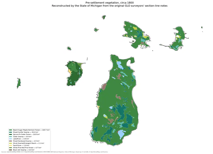
This is especially useful for comparing tree history with soils and landforms. The preserved GLO excerpts retain sandy or stony ground, beach ridges, marshes, swamps, fire, windfall, and cutting alongside the tree names. Those are page-bounded environmental associations, not inferred habitat polygons.
Modern public-forest comments
The MIFI extraction contributes 1,369 sentence-level matches from 323 distinct stand-comment source records, all in the Beaver Island public-inventory query. It captures modern narrative vocabulary such as beech bark disease, emerald ash borer, deer browse, windthrow, regeneration, old growth, and transitions among aspen, cedar, fir, hemlock, maple, birch, oak, pine, spruce, ash, willow, and balsam poplar.
These comments add management and disturbance connectivity that a covertype code cannot provide. They also have strict limits: comments may use shorthand, typos, broad common names, or inherited observations; repeated mentions are not independent trees; and the public stand layer does not cover private land or the other islands in this query. The index retains the exact matched sentence and stand locator so the source can be reviewed before interpretation.
The 2024 guide’s tree list
The MNFI landowner guide contributes 16 explicitly labeled tree entries, including northern white cedar, balsam fir, black spruce, white and red pine, tamarack, white spruce, American beech, balsam poplar, basswood, ironwood, red oak, sugar maple, white ash, and yellow birch. The guide itself presents this as a non-exhaustive native-plant list without assigning each entry to an island. It is therefore a useful taxonomic bridge, not a distribution table.
Evidence limits
The index is a searchable evidence layer, not a complete flora, forest inventory, or species-distribution map. Historical common-name normalization can be uncertain; MNFI records are occurrence-bounded; the guide list is non-exhaustive; and MIFI comments are narrative stand attributes. Island labels such as “Garden and Hog Islands” are preserved rather than split into unsupported separate records. The index does not infer abundance, age, basal area, habitat suitability, ownership, or current presence from a name mention.
See also
- Forest types and tree history
- Pre-settlement landscape and environmental history
- Lumbering
- Visually verified GLO survey observations of archipelago soils, terrain, and trees, 1845–1849
- MNFI soil, vegetation, tree, and wildlife crosswalk, 2017
- MNFI Natural Community Surveys of Beaver Island Archipelago, 2017
- Beaver Island biodiversity appendices and island distribution records, 2017–2024
- Michigan DNR public forest inventory stand covertype crosswalk, 2026
Sources
- Project-generated MNFI natural-community ecological connectivity matrix (2026).Aggregates this index’s MNFI tree evidence with plant, wildlife, soil/hydrology, and disturbance evidence at the shared occurrence ID. No public copy of this file is known; the archive holds one and can provide it on request.research · island_farming · crosswalks · mnfi_natural_community_connectivity_matrix
- Project-generated tree and woody vegetation evidence index (2026).Contains 1,916 source matches across 50 normalized labels, preserving source class, island, year where supplied, reported name, scientific name, evidence text, and locator. Counts are evidence records, not individual trees or abundance. No public copy of this file is known; the archive holds one and can provide it on request.research · island_farming · indices · tree_woody_vegetation_evidence_index
- Project build script for the tree and woody vegetation index.Reproduces source-specific extraction from GLO normalized names, MNFI tree terms, the MNFI tree appendix, and sentence-level MIFI GeneralComments matches. No public copy of this file is known; the archive holds one and can provide it on request.scripts · build_tree_woody_vegetation_evidence_index
- Supplies page-bounded historical tree names, survey years, island or group labels, disturbance/soil context, and visual-verification locators. The holder's public portal is searchable but does not link this record directly; the archive holds a copy of the file and can provide it on request.research · land_cover · crosswalks · glo_ecology_crosswalk_1845_1849
- Project-generated MNFI soil, vegetation, and wildlife crosswalk, based on Report 2017-11.Supplies occurrence-level tree terms, scientific names as reported, community types, site names, tree ages/structure where present, and source excerpts. No public copy of this file is known; the archive holds one and can provide it on request.research · island_farming · crosswalks · mnfi_soil_vegetation_wildlife_crosswalk
- Project-generated biodiversity appendices from the MNFI 2024 landowner guide and MDNR plan.Supplies the 16 explicitly labeled tree entries in the guide’s non-exhaustive native-plant appendix. No public copy of this file is known; the archive holds one and can provide it on request.research · island_farming · indices · beaver_biodiversity_2017_2024
- Provides Beaver Island public-inventory stand attributes and GeneralComments from which sentence-level tree/woody mentions are extracted; it is not a private-land or complete species inventory.research · forest_inventory · sources · mdnr_mifi_stand_covertype_query_2026-08-03
Added 3 August 2026. Recent changes
Cite this article
Beaver Island Archive, “Tree and woody vegetation evidence index for the Beaver archipelago, 2026”, https://beaverislandarchive.org/documents/tree-woody-vegetation-evidence-index-2026/, accessed [date], citing Project-generated MNFI natural-community ecological connectivity matrix (2026). (and 6 further sources listed on the page).
Last revised 2026-08-03. Fill in [date] with the date you read it — this page is static and cannot know that.
BibTeX for “Tree and woody vegetation evidence index for the Beaver archipelago, 2026”RIS for “Tree and woody vegetation evidence index for the Beaver archipelago, 2026”