

- Date
- 1907
- Eras
- Modern era
- Concepts
- maritimeshippinglighthousesheritagetransportationsettlementland-survey
- Within
- Beaver Island archipelago
Summary
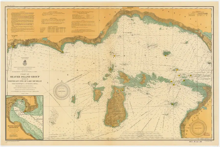
This held NOAA chart is the 1907 Chart of Beaver Island Group Including the Northeast End of Lake Michigan from Manistique to St. Helena Shoal (LSMa), at catalog scale 1:120,000. It is a primary navigational-map snapshot of the archipelago within a broader Manistique-to-St. Helena Shoal coverage area.
Inland road axis
Direct review of the full-resolution master makes the north-south road pattern clearer than it is on the 1855 chart. A road or cleared corridor runs south from Saint James, while a separate, nearly collinear segment rises north from the northeastern side of Lake Geneserath. The sheet does not draw an unbroken road between them: a substantial blank interval remains in the island interior. The straight dark line immediately east of the road is the 85 degrees 30 minutes longitude graticule, not a second road or a continuation through that interval.1
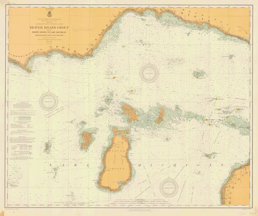
The comparison becomes less ambiguous on the larger-scale 1911 chart, which labels the northern road “Kings Highway” while retaining the break and the separate lake-side segment.2 The 1907 chart therefore supports a common broad axis between the historical road and modern King’s Highway, but it does not support a continuously drawn road all the way to the lake.
The 1907 sheet’s own authorities panel also limits what its date can mean. It attributes the topography east of the Hat Island meridian, including Beaver Island, principally to Lake Survey work of 1854-55; the later work listed for 1902-05 is chiefly hydrographic and shoal surveying. The cleaner 1907 rendering is consequently valuable corroboration and clarification of the earlier topography, not independent proof that the whole inland road was resurveyed or remained passable in 1907.1
What the title block states
Read at full resolution the sheet describes itself precisely, and the wording matters more than the date printed on it:
SURVEY OF THE NORTHERN AND NORTHWESTERN LAKES. Made in obedience to Acts of Congress and orders from HEADQUARTERS CORPS OF ENGINEERS, U.S. ARMY. CHART OF BEAVER ISLAND GROUP INCLUDING THE NORTHEAST END OF LAKE MICHIGAN, FROM MANISTIQUE TO ST. HELENA SHOAL. From trigonometrical Surveys under the direction of Captain J. N. Macomb, Topographical Engineers, in 1854 & 1855. Additions and Corrections under the direction of […]
So the base of this sheet is Macomb’s survey of 1854–55, carried forward with later additions and corrections — more than half a century between the trigonometrical work and this issue. A feature drawn here may be as old as the 1850s or as recent as the last correction, and the sheet does not say which. The companion 1911 sheet makes the same compilation explicit in an Authorities panel naming four campaigns between 1853 and 1911.
Note also that the two charts are not the same extent. This one runs “from Manistique to St. Helena Shoal”, covering the north-east end of the lake; the 1911 sheet runs “from Waugoshance Point to Seul Choix Point”. Comparing them for change over time means first checking that the ground in question is on both.
Around the title the sheet carries bearing-and-distance notes of the kind a navigator used rather than a surveyor — “S. 4¼ W., 85¼ miles to Point Betsie Light” is lettered along a dashed line running off the sheet — and its soundings are annotated with bottom character, clay, hard, sand, which is holding ground information for anchoring, not depth alone.
Evidence and limits
The NOAA catalog and provenance establish the chart’s title, chart number, year, type, scale, stated coverage, public-domain status, and held image. This is a navigational source from 1907, not a present-day navigation aid or a complete record of ownership, settlement, traffic, light operation, or every feature shown on the sheet.
The interruption itself is cartographic evidence, not an explanation. The sheet does not label the gap as swamp, say that wet ground caused it, or distinguish among an unfinished road, an impassable or seasonal section, an unmapped trail, and deliberate omission. Those alternatives require textual, survey, or road-maintenance evidence.
Beaver Harbor inset
The held sheet includes a detailed Beaver Harbor inset based on a 1903 survey. Direct visual review shows the labels “St. James,” “Gallagher Dock,” “Beaver I. Harbor Lt.” (fixed red, visible 13 miles), and “Life Sav. Sta.” It therefore supplies a dated navigational-map context for the harbor, the Gallagher Dock, the harbor light, and the life-saving station. Those labels do not establish ownership, a complete facility inventory, traffic, operation, or exact modern footprints.
See also
- North End of Lake Michigan Including the Beaver Island Group, 1855 Lake Survey chart
- Beaver Island Group nautical chart, 1911
- Scott's New Coast Pilot for the Lakes
- King's Highway
- Lake Geneserath
- Saint James
- Galilee
- Saint James Harbor
- Gallagher Dock
- Beaver Island Harbor Light
- Beaver Island Life-Saving Station
- Shipping and navigation
Sources
Footnotes
Sources
- Held 11,333 x 7,537-pixel NOAA chart image, read directly at full and cropped resolution. The sheet depicts two nearly collinear inland road or cleared-corridor segments: one extending south from Saint James and a separate short segment extending north from the northeastern side of Lake Geneserath. A blank interval remains between them. The chart does not state why they are disconnected.federal · noaa_charts · images · 1907_CHART-OF-BEAVER-ISLAND-GROUP-INCLUDING-THE-NORTHEAST-END-OF-LAKE-MICHI_LC0000Ma_02_1907_LS
- Project provenance sidecar for NOAA chart LSMa.Records the source URL, retrieval timestamp, checksum, 62,268,060-byte file size, NOAA public-domain status, filename, chart number, and scale. No public copy of this file is known; the archive holds one and can provide it on request.federal · noaa_charts · images · 1907_CHART-OF-BEAVER-ISLAND-GROUP-INCLUDING-THE-NORTHEAST-END-OF-LAKE-MICHI_LC0000Ma_02_1907_LS.provenance
- Catalog metadata gives year 1907, nautical-chart type, scale 1:120,000, chart number LSMa, and stated Manistique–St. Helena Shoal coverage.federal · noaa_charts · noaa_charts_aoi
- Described in this archive: Beaver Island Group nautical chart, 1911.Later, larger-scale comparison chart. It explicitly labels the northern road "Kings Highway" and more clearly shows both the break and the separate segment north of Lake Geneserath.federal · noaa_charts · images · 1911_BEAVER-ISLAND-GROUP-INCLUDING-NORTH-SHORE-OF-LAKE-MICHIGAN-FROM-WAUGOS_72-9-1911


Added 2 August 2026 · revised 4 August 2026. Recent changes
Cite this article
Beaver Island Archive, “Beaver Island Group nautical chart, 1907”, https://beaverislandarchive.org/documents/noaa-beaver-island-group-chart-1907/, accessed [date], citing NOAA Office of Coast Survey, Historical Map & Chart Collection, “Chart of Beaver Island Group Including the Northeast End of Lake Michigan from Manistique to St. Helena Shoal,” chart LSMa, 1907. (and 3 further sources listed on the page).
Last revised 2026-08-04. Fill in [date] with the date you read it — this page is static and cannot know that.
BibTeX for “Beaver Island Group nautical chart, 1907”RIS for “Beaver Island Group nautical chart, 1907”