

- Date
- 1855
- Concepts
- maritimeshippinglighthousesland-surveytransportationsettlement
Summary
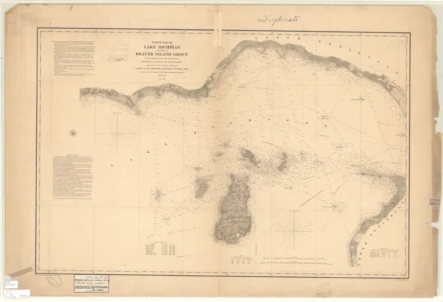
This is a 1:120,000-scale chart of the north end of Lake Michigan and the Beaver Island group, engraved from trigonometrical surveys directed by Capt. John N. Macomb, Topographical Engineers, in 1854 and 1855, as part of the US government’s Survey of the Northern and Northwestern Lakes.1 The scan held here is a “Duplicate” print bearing a handwritten presentation inscription: “Detroit April 1st 1861. Presented to the Geographical & Statistical Soc’y of N.Y. with Capt. Meade’s compl’ts,” signed in print below by “Geo. G. Meade, Capt. Top’l Engineers, Sup’t Survey N. and N.W. Lakes.”2 This is George Gordon Meade, who would command the Army of the Potomac at Gettysburg two years later; in 1861 he was Superintendent of the US Survey of the Northern and Northwestern Lakes, based in Detroit. The chart predates and independently corroborates several details in Scott's New Coast Pilot for the Lakes (1902), while also showing how the light stations changed in the intervening decades.
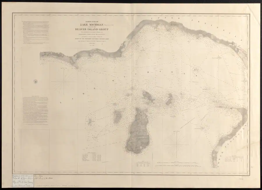
A separately catalogued Leventhal Map & Education Center impression, whose provenance gives publication as [1857], is also held. It carries the same title and 1854–55 survey statement. This confirms the chart’s wider surviving holding history but does not resolve whether its title-block date, the NOAA catalogue year, or a specific later impression date should control a single publication-date claim.
Contents
Title block: “NORTH END OF LAKE MICHIGAN INCLUDING THE BEAVER ISLAND GROUP. From trigonometrical Surveys under the direction of the Topographical Bureau of the War Department in obedience to Acts of Congress requiring the Survey of the Northern and North Western Lakes under the orders of Captain J.N. Macomb Topographical Engineers in 1854 & 1855. Scale 1/120,000.” Engraved by W. H. Dougal.1
Triangulation credits note (transcribed in full from the chart): general triangulation and hydrography remote from shore by Capt. J. N. Macomb; secondary triangulation, topography and minute hydrography of Hog Island, Garden Island and the north end of Beaver Island by Lieut. W. F. Raynolds in 1854; of the remainder of Beaver Island and the north coast west of Point Patterson by assistants W. H. Hearding, J. H. Foster and J. L. Beghem in 1855; of the north coast from Pt. Patterson to Mille Coquins Point by assistants G. W. Lamson and D. F. Henry in 1854; and of “High, Gull, Trout, Whiskey and Squaw Islands, and of the North coast from Mille Coquins Point to Hat Island meridian,” by assistants G. W. Lamson, H. Gillman and sub-assistant J. B. Williams in 1855.1 This directly documents the earliest systematic American survey of Gull Island Reef, High Island and the island now called Ojibwa Island (see Squaw Island Light Station).
“Light Houses” table (bottom right of the sheet), transcribed in full:
| Name and Locality | Character | Height above lake (ft) | Visible (statute miles) |
|---|---|---|---|
| Wangoshance Lt. Ho. | Fixed, varied by flashes | 80 | 17 |
| Île aux Galets Lt. Ho. | fixed red | 25 | 11½ |
| Beaver Harbor Lt. Ho. | fixed | 30 | 12½ |
| Head of Beaver Id. Lt. Ho. | revolving | 110 | 19 |
No Squaw Island light appears in this table, consistent with the chart’s own 1855 survey crediting no light there yet (see Squaw Island Light Station).1
“Sailing Directions” box (left side of the sheet) gives compass routes between Beaver Harbor, Waugoshance Light House, Manitou Passage, Green Bay and Chicago, all corrected to true meridian with distances in statute miles — including “From Waugoshance Light House to Light House on South bluff, head of Beaver Island, 28¾ miles,” a direct predecessor to the routes tabulated in Scott's New Coast Pilot for the Lakes 47 years later.1
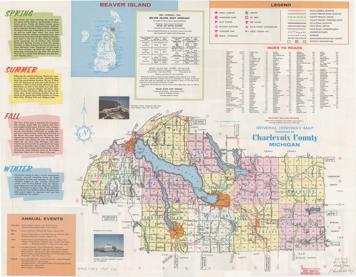
Inland road and settlement corridor: although prepared as a nautical chart, the sheet also shows inland topography in unusually useful detail. At Saint James/Beaver Harbor it depicts dense rectangular clearings, from which an approximately north-south corridor extends into the island. Farther south are additional aligned clearings and a linear trace running north from the northeastern vicinity of the lake now called Lake Geneserath.1 These features are unlabeled. Their form and orientation are consistent with Strang’s 1854 statement that a principal road ran from Saint James “due South to Galilee” and that long farm lots abutted the two main roads.3 This is strong contextual identification of a Strang-era road-and-farm axis, but not direct evidence that the Lake Survey called it King’s Highway or that its full centerline exactly matches the modern road.
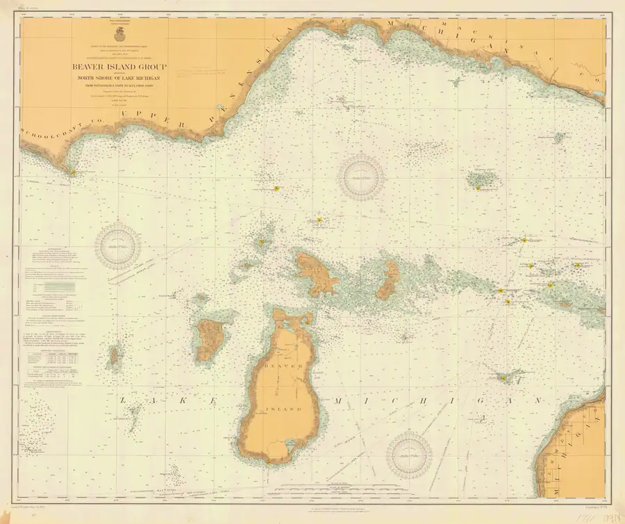
The 1907 chart more clearly redraws two nearly collinear but disconnected segments. The 1911 chart then labels the northern segment “Kings Highway” while again leaving a substantial blank before the separate segment north of Lake Geneserath.4 Those later sheets strengthen the road’s identification and the reality of the mapped interruption; because their authorities include earlier Lake Survey work, they do not prove that the road was newly surveyed or continuously passable at either later issue date.
Significance
Held alongside Scott’s 1902 Coast Pilot, this chart lets several claims about the Beaver Island lights be checked across nearly half a century: the Beaver Harbor light’s height above the lake nearly doubled (30 ft revolving “fixed” light $\to$ 34 ft tower with red 4th-order lens after an 1870 rebuild, per Elizabeth Whitney Williams’s memoir — see Beaver Island Harbor Light), the head-of-island light’s character changed from “revolving” to “fixed, varied by flashes,” and the Squaw Island light did not yet exist. The Meade presentation inscription also documents the pre-Civil War US Lake Survey’s institutional history and its superintendent’s identity, independent of Meade’s later Civil War fame.
Open questions
- The exact print/reissue history of this chart between the 1854-55 survey date and the 1861 presentation inscription is not established: was the “Light Houses” table part of the original 1855 plate, or added/updated on a later state of the same plate before this 1861 duplicate was pulled? The chart’s own title block gives only the survey years, not a printing date.
- The identity of the American Geographical and Statistical Society recipient individual (if any, beyond the Society itself) is not given on the sheet.
- No corresponding textual (non-chart) 1850s-60s sailing-directions pamphlet has yet been found to cross-check the “Sailing Directions” box against contemporary prose.
- The inland corridor has not yet been control-point georeferenced against modern road centerlines or cadastral records. Until that work is done, visual alignment with King’s Highway should be described as a close broad-axis match, not a perfect overlay.
See also
Sources
Footnotes
-
US Lake Survey, “North End of Lake Michigan Including the Beaver Island Group” (1854-55), full-resolution image,
data/federal/noaa_charts/images/1855_NORTH-END-OF-LAKE-MICHIGAN-INCLUDING-THE-BEAVER-ISLAND-GROUP-NORTH-END_LC00010-00-1855WWL.jpg, read directly (title block, triangulation-credit note, “Light Houses” table and “Sailing Directions” box each transcribed from cropped full-resolution regions). ↩ ↩2 ↩3 ↩4 ↩5 ↩6 -
Presentation inscription, same image, lower-center panel, transcribed directly: “Detroit April 1st 1861. Presented to the Geographical & Statistical Soc’y of N.Y. with Capt. Meade’s compl’ts” over the printed form “Geo. G. Meade, Capt. Top’l Engineers, Sup’t Survey N. and N.W. Lakes.” ↩
-
Strang, Ancient and Modern Michilimackinac (1854), pp. 44-45. ↩
-
NOAA Office of Coast Survey, charts LSMa (1907) and LS72 (1911), held full-resolution images. ↩
Sources
- Full-resolution scan, 12,672 x 8,664 px (confirmed via PIL), read directly at full and cropped resolution to transcribe title block, sailing directions, triangulation credits and the presentation stamp.federal · noaa_charts · images · 1855_NORTH-END-OF-LAKE-MICHIGAN-INCLUDING-THE-BEAVER-ISLAND-GROUP-NORTH-END_LC00010-00-1855WWL
- Catalogue metadata (bbox, chart number, scale, download URL) for the same chart; one of 186 charts in the AOI catalogue.federal · noaa_charts · noaa_charts_aoi
- A separately held 7,479×5,433-pixel impression. Visual inspection confirms the same title, 1854–55 survey statement, and named island group; the holding’s provenance catalogues publication as [1857]. It supports a distinct holding/impression record, not a content-level difference from the NOAA scan or a resolution of the chart’s precise print history.maps · leventhal · us_lake_survey_1857_north_end_lake_michigan · full_image
- Project provenance sidecar for the Leventhal/Digital Commonwealth Lake Survey chart holding.Records the Digital Commonwealth source URL, retrieval timestamp, checksum, dimensions, and no-known-restrictions statement. No public copy of this file is known; the archive holds one and can provide it on request.maps · leventhal · us_lake_survey_1857_north_end_lake_michigan · full_image.provenance
- Described in this archive: Ancient and Modern Michilimackinac, 1854.Contemporary textual comparison for the chart's inland clearings: Strang says a principal road ran from Saint James due south to Galilee and that long farm lots abutted the island's two principal roads. The text does not name King's Highway.
- Later comparison map. Its Beaver Island inset labels the northern road "KINGS HI" (the map's abbreviation for King's Highway) only north of Hannigan Road, helping distinguish the modern named segment from the longer and unlabeled 1850s chart corridor.historical_maps · msu_charlevoix_plats · charlevoix-county-highway-map-1965-recto
- Described in this archive: Beaver Island Group nautical chart, 1911.Later chart comparison. The 1907 sheet more clearly renders the two nearly aligned but disconnected segments; the 1911 sheet explicitly labels the northern road "Kings Highway" and retains the break before the separate segment north of Lake Geneserath. Their compilation history does not establish a new survey date for every inland feature.federal · noaa_charts · images · 1911_BEAVER-ISLAND-GROUP-INCLUDING-NORTH-SHORE-OF-LAKE-MICHIGAN-FROM-WAUGOS_72-9-1911


Added 28 July 2026 · revised 9 August 2026. Recent changes
Cite this article
Beaver Island Archive, “North End of Lake Michigan Including the Beaver Island Group, 1855 Lake Survey chart”, https://beaverislandarchive.org/documents/lake-survey-chart-1855/, accessed [date], citing US Lake Survey (Topographical Bureau, War Department), 'North End of Lake Michigan Including the Beaver Island Group,' from trigonometrical surveys under the orders of Capt. J. N. Macomb, Topographical Engineers, 1854 & 1855, scale 1:120,000, Lake Survey First Series chart no. LS10 / catalogue filename LC00010-00-1855WWL. (and 6 further sources listed on the page).
Last revised 2026-08-09. Fill in [date] with the date you read it — this page is static and cannot know that.
BibTeX for “North End of Lake Michigan Including the Beaver Island Group, 1855 Lake Survey chart”RIS for “North End of Lake Michigan Including the Beaver Island Group, 1855 Lake Survey chart”