

- Date
- 1911
- Eras
- Modern era
- Concepts
- maritimeshippinglighthousesheritagetransportationsettlementland-survey
- Within
- Beaver Island archipelago
Summary
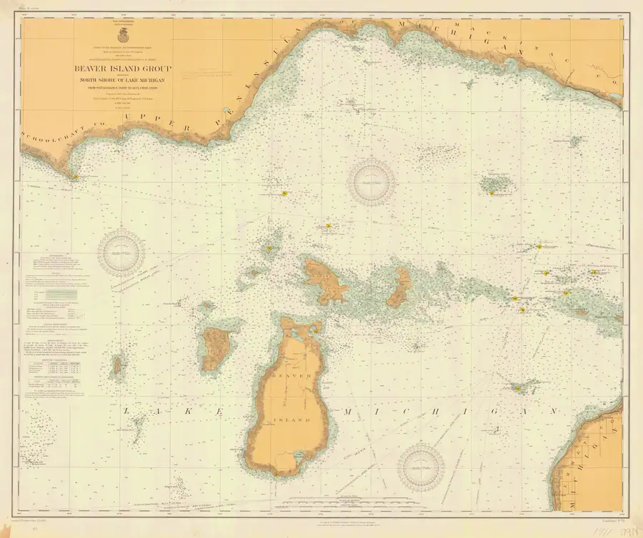
This held NOAA chart is the 1911 Beaver Island Group Including North Shore of Lake Michigan from Waugoshance Point to Seul Choix Point (LS72), at catalog scale 1:80,000. It provides a primary navigational-map snapshot of the archipelago and adjacent north Lake Michigan shore.
King’s Highway and the Lake Geneserath gap
This is the strongest chart evidence yet located for identifying the northern historical road. The Beaver Island detail prints “Kings Highway” along the double-line road descending south from Saint James. That road ends in the island interior. Farther south, a separate short road segment rises from the northern or northeastern side of Lake Geneserath, close to the same north-south axis, but no road line joins the two.1
A working measurement against the printed latitude graticule puts the blank north-south interval at approximately 1.9 miles (3.1 km). That is an image-derived estimate, not a control-point georeference, surveyed distance, or route measurement. It nevertheless confirms that the apparent break is substantial rather than a momentary loss of ink or a narrow stream crossing.
Modern National Wetlands Inventory polygons place forested and shrub wetlands across much of the comparable interior corridor.2 That makes wet ground a credible interpretation of the setting, especially when read with later descriptions of cedar-swamp stumps and an old road or trail. The chart itself, however, does not state that swamp caused the break. It cannot distinguish an unfinished road, an abandoned or seasonal section, an unmapped trail, or a cartographic omission.
What the sheet states about itself
Read at full resolution, the left-margin panels are the most useful thing on the chart, because they say how it was made and how it must be read.
Authorities. “United States Lake Surveys made under Captain J. N. Macomb, Top. Engineers, U.S. Army, in 1853–1855; Major W. L. Fisk, Corps of Engineers, U.S. Army, in 1902–1905; Major Charles Keller, Corps of Engineers, U.S. Army, in 1907 and Lieut. Col. C. S. Riché, Corps of Engineers, U.S. Army, in 1911. Chart preparation under the supervision of Edward Molitor, Ass’t Engr.”
So the sheet is a compilation spanning fifty-eight years, not a survey of 1911. The title block adds that it was prepared under Riché “in 1910 and 1911” at a scale of 1:80,000, by the War Department, Corps of Engineers, Survey of the Northern and Northwestern Lakes. Any feature on it may date from any of those campaigns, which is the same caution the Evidence section below applies to the inland road.
Two units on one sheet. The Notes state: “Water areas with depths to 6, 12, 18 and 21 feet are tinted in blue. Depths within tinted areas are in feet, those on untinted areas are in fathoms.” A sounding read without first checking whether it sits inside the blue tint is wrong by a factor of six, and nothing on the number itself says which it is.
The shoreline is a stage, not a line. The Notes also say the shore line is “the intersection with the land of the water surface at time of survey”, and the sheet’s own table of comparative elevations on Lake Michigan, referred to mean tide at New York on the adjusted levels of 1903, gives:
| feet | |
|---|---|
| High water of 1838 | 584.69 |
| Mean stage 1860–1875 (old chart plane) | 581.63 |
| Mean stage 1860–1910, both inclusive | 581.28 |
| Lowest recorded monthly mean (December 1895) | 578.98 |
| Plane of reference of this chart (standard low water) | 578.50 |
That is a 6.19-foot spread between the 1838 high water and this chart’s own datum. Comparing a shoreline drawn here against a modern one therefore compares two lake stages as much as two coastlines, and the difference is not error.
Latitudes and longitudes are “based on the U.S. Standard datum adopted in 1901” — that is, pre-NAD27, so positions read off this sheet need a datum shift before they can be set beside modern coordinates.
Evidence and limits
The NOAA catalog and provenance establish the chart’s title, chart number, year, type, scale, stated coverage, public-domain status, and held image. The chart is a navigational source from 1911, not a present-day navigation aid or a complete record of ownership, settlement, traffic, light operation, or every feature shown on the sheet.
Its authorities panel cites Lake Survey work from 1853-55, 1902-05, 1907, and 1911. Without a feature-level compilation record, the issue date alone does not prove that the inland road was newly ground-surveyed in 1911 or passable then.
See also
- Beaver Island Group nautical chart, 1907
- Beaver Island Group nautical chart, 1923
- Beaver Island Group nautical chart, 1929
- Scott's New Coast Pilot for the Lakes
- King's Highway
- Lake Geneserath
- Saint James
- Galilee
- Wetland inventory ArcGIS layers for the Beaver Island archipelago
- Shipping and navigation
Sources
Footnotes
Sources
- Held 16,431 x 13,759-pixel NOAA chart image, read directly at full and cropped resolution. The Beaver Island detail explicitly labels the northern double-line road "Kings Highway," shows that road ending in the interior, and depicts a separate road segment extending north from Lake Geneserath. The chart gives no cause for the intervening break.federal · noaa_charts · images · 1911_BEAVER-ISLAND-GROUP-INCLUDING-NORTH-SHORE-OF-LAKE-MICHIGAN-FROM-WAUGOS_72-9-1911
- Project provenance sidecar for NOAA chart LS72.Records the source URL, retrieval timestamp, checksum, 26,513,990-byte file size, NOAA public-domain status, filename, chart number, and scale. No public copy of this file is known; the archive holds one and can provide it on request.federal · noaa_charts · images · 1911_BEAVER-ISLAND-GROUP-INCLUDING-NORTH-SHORE-OF-LAKE-MICHIGAN-FROM-WAUGOS_72-9-1911.provenance
- Catalog metadata gives year 1911, nautical-chart type, scale 1:80,000, chart number LS72, and stated Waugoshance Point–Seul Choix Point coverage.federal · noaa_charts · noaa_charts_aoi
- Described in this archive: Wetland inventory ArcGIS layers for the Beaver Island archipelago.Modern comparison layer. It maps forested and shrub wetland across much of the general charted gap corridor, but it is not a historical field survey, a legal wetland determination, or proof that swamp caused the road interruption shown in 1911.federal · layers · nwi_wetlands

Added 2 August 2026 · revised 4 August 2026. Recent changes
Cite this article
Beaver Island Archive, “Beaver Island Group nautical chart, 1911”, https://beaverislandarchive.org/documents/noaa-beaver-island-group-chart-1911/, accessed [date], citing NOAA Office of Coast Survey, Historical Map & Chart Collection, “Beaver Island Group Including North Shore of Lake Michigan from Waugoshance Point to Seul Choix Point,” chart LS72, 1911. (and 3 further sources listed on the page).
Last revised 2026-08-04. Fill in [date] with the date you read it — this page is static and cannot know that.
BibTeX for “Beaver Island Group nautical chart, 1911”RIS for “Beaver Island Group nautical chart, 1911”