

- Intersects
- Barney's Lake Road South · Bonner's Landing Road · Buff-Kett Road · Donnel Mor's Lane · King's Highway · Protar's Tomb Road · Ricksgers Drive
- Coordinates
- 45.7033° N, 85.5525° WGoogle Maps: Sloptown RoadDownload KML
- Eras
- Modern era
- Concepts
- transportationtoponymy
- Within
- Beaver Island archipelago
- Media
- Beaver Island History Map, 1978 revision
Summary
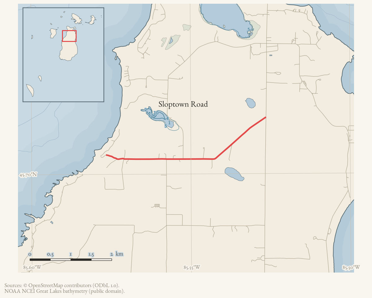
Sloptown Road is a named road on Beaver Island’s current OpenStreetMap map.
The three held ways carrying that name are merged here into one route geometry
of about 4.3 km. It meets seven other named roads, listed under
intersects_road.
Evidence and limits
The name and the alignment are what mappers last entered, and OpenStreetMap is
volunteered work rather than a survey: it settles neither the right-of-way nor
who maintains the road. Where the name came from is a separate question. Plats,
road-commission minutes, and island memory answer that one. Put an older
spelling from any of them into alt_names or former_names, with the source
that attests it.
The 1978 Beaver Island History Map explains the name by saying farmers along the road raised pigs. The annotation audit found independent historical and current uses of Sloptown, but no source for that explanation. It is therefore preserved as the map’s folk etymology, not presented as established name origin.
Documented associations
These source-backed records provide context for the mapped route:
- Boyle family of Sloptown Road — The Boyle family of Sloptown Road is a documented Beaver Island family cluster associated with a farm near Piper's Corner and Sloptown Road. A February 2026 interview identifies Dan P. Boyle (“Turner”) and Maggie Boyle as the maternal grandparents of Eleanor Gallagher McDonough. It also reports a memorial stone at the corner and…
- Daniel P. "Turner" Boyle — ## History In June 1945 a Charlevoix County Herald feature interviewed a Beaver Island fisherman it called Dan “Turner” Boyel, “a fine specimen of robust health — bright pink cheeks, sparkling eyes, pure-white hair, with an infectious smile and laugh,” born on the island in 1872. Asked about his nickname, he told the reporter: “Me father was Dan Boyel, and…
- Feodor Protar — Feodor Protar (born Friedrich Parrot, 19 February 1837 - 3 March 1925) was a Russian-born former actor and newspaper editor who settled alone on Beaver Island in 1893 and became, without formal medical license, the island’s principal source of care in the years it had no resident physician. Islanders were by the 1890s overwhelmingly…
- Maggie Boyle — Margaret “Maggie” Gallagher Boyle (1865–1957) christened the Emerald Isle ferry at Saint James in April 1955, when the Beaver Beacon described her as 90 years old and the island’s oldest island-born resident. She was the wife of Daniel P. "Turner" Boyle and, in a 2026 family interview, is identified as the maternal grandmother…
- Bonner’s Bluff State Beach — Bonner’s Bluff State Beach, also identified in the recreation inventory as Bonner’s Landing, is a public Lake Michigan beach at the end of a private road off Sloptown Road. The inventory describes approximately 1,500 feet of beach and access over private land.
- Piper's Corner — Piper’s Corner is a locally used Beaver Island locality near Sloptown Road and Bonners’. A Helen Collar research-card note places it just east of Bonners’ and attributes the name to Dan Gallagher, called “Piper.” A February 2026 Northern Islander family-history feature independently uses Piper’s Corner as a reference point for the Boyle family…
- Protar's Cabin — The cabin standing here predates Feodor Protar and was not built by him. It is a hand-hewn white pine log structure, one and one-half stories, about 32 by 16 feet, built around 1860 — according to the 1971 National Register nomination, by Irish settlers who moved onto the island after the Strangite Mormons were dispossessed in 1856. Protar first…
Research status
The local newspaper and website corpus contains exact-name mentions in 35 file(s). Those files are research leads; the relation layer is added only when the surrounding source text establishes that the record involves this road.
Maps for this place
These Atlas plates provide regional context. They do not establish a precise boundary, current ownership, access right, operating status, or field condition.
- EnvironmentSoils, wetlands, hydrography, and terrain
- GeologyGeneralized geology and landforms
- HydrologyMapped water and wetland context
- AccessMapped routes, facilities, and protected areas
- Land surveyPLSS geometry and historic GLO patent-location context
Sources
- Current mapped road name 'Sloptown Road'; grouped OSM way ids: 17754706, 17758593, 265446954. This is a volunteered map record, not a surveyed right-of-way or proof of historical naming.osm · roads
- Beaver Island Historical Society, *Beaver Island History Map* (copyright 1978), Sloptown Road label.The map says the road was so named because farmers raised pigs. No independent source located in the annotation audit supports that etymology, so it remains attributed to the map.
Added 2 August 2026 · revised 7 August 2026. Recent changes
Cite this article
Beaver Island Archive, “Sloptown Road”, https://beaverislandarchive.org/places/sloptown-road/, accessed [date], citing OpenStreetMap contributors, roads via Overpass API, retrieved 2026-08-01 (ODbL 1.0). (and 1 further source listed on the page).
Last revised 2026-08-07. Fill in [date] with the date you read it — this page is static and cannot know that.