

- Date
- 1744
- Eras
- French era
- Concepts
- toponymyheritageFrench era
- Within
- Beaver Island archipelago
Summary
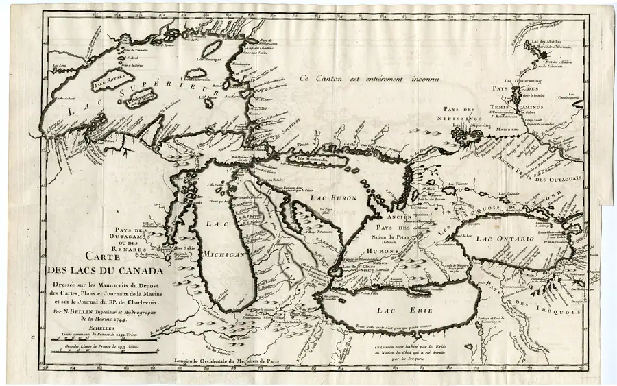
Carte des Lacs du Canada is a regional engraved map of the Great Lakes published in 1744 by Jacques-Nicolas Bellin, hydrographer to the French Marine. In northern Lake Michigan it prints the name I. du Castor — Beaver Island — against a small group of islands, making it one of the earliest engraved attestations of the French form of the name this archive traces in the toponymy survey.
The sheet
The title cartouche, at lower left, states the map’s own sources:
CARTE DES LACS DU CANADA, Dresée sur les Manuscrits du Depost des Cartes, Plans et Journaux de la Marine et sur le Journal du R.P. de Charlevoix. Par N. Bellin Ingenieur et Hydrographe de la Marine 1744.
Two of those are worth separating. The Dépôt des cartes, plans et journaux de la Marine was the French navy’s hydrographic office, where Bellin worked from manuscript charts and pilots’ journals. The other named source is the journal of Père Charlevoix, whose account of the same waters the archive also holds and serves page by page — see Charlevoix’s Journal historique, published in the same year. The map and the narrative are companion products of one French project, not independent witnesses, and a name appearing on both is one attestation rather than two.
Below the cartouche are two scale bars, in lieues communes de France of 2,282 toises and grandes lieues de France of 2,853 toises. The lower neatline reads “Longitude Occidentale du Meridien de Paris”: longitudes are measured west of Paris, not Greenwich, and any coordinate read off this sheet has to be shifted by roughly 2°20′ before it can be compared with a modern position.
What it shows near the archipelago
I. du Castor sits in the open water of northern Lake Michigan, south-west of the straits at Michillimakinac and west of Isle Manitoualin. Nearby the engraver has set B. les Noquets to the west and I. des Poutouatamis to the south. The lettering is regional: the group is drawn as a scatter of small marks at a scale where individual islands cannot be counted or matched to modern ones with any confidence, and this article does not attempt to do so. What the sheet establishes is the name, in print, in 1744.
Evidence and limits
The map’s chief virtue as evidence is that it says where it stops. Across the country north of Lake Huron it prints “Ce Canton est entierement inconnu” — this district is entirely unknown. Along the Georgian Bay shore: “Toute cette Coste n’est point connue”. Along the south shore of Lake Erie: “Toute cette coste n’est presque point connue”. A cartographer willing to letter three blanks that plainly is a cartographer whose filled areas can be weighed rather than simply believed.
The same caution applies to the archipelago itself. The sheet is a record of what the Marine’s office held in Paris in 1744 and what Charlevoix reported. It does not establish the modern boundary of the group, does not supply an island inventory, and does not show that anyone on or near Beaver Island used the label in the way the map does — least of all the Anishinaabe communities whose presence long predates it and whose own naming is treated in Anishinaabe presence in the archipelago.
Open questions
- Which of the drawn islands in the “I. du Castor” cluster correspond to which modern islands has not been established, and the map’s scale does not support one.
- Whether Bellin’s manuscript sources named the group independently of Charlevoix’s journal, or only repeated it, is not resolved from the sheet itself.
- The print and plate history of this 1744 edition — states, reissues, corrections — has not been traced here.
See also
Sources
- The map provenance records the label “I. du Castor” for a four-island group near l’Ours qui dort and identifies the cartouche as drawing on Charlevoix’s journal. It establishes a 1744 engraved French cartographic attestation, not a modern boundary, a complete island count, local speech, title, or a direct identity claim for every island depicted.maps · commons · bellin_1744_carte_des_lacs
- Project provenance sidecar for Bellin 1744 map.Records source URL, retrieval timestamp, checksum, file size, and public-domain scan status. No public copy of this file is known; the archive holds one and can provide it on request.maps · commons · bellin_1744_carte_des_lacs.provenance

Added 2 August 2026 · revised 4 August 2026. Recent changes
Cite this article
Beaver Island Archive, “Bellin Carte des Lacs du Canada, 1744”, https://beaverislandarchive.org/documents/bellin-carte-des-lacs-du-canada-1744/, accessed [date], citing Jacques-Nicolas Bellin, *Carte des Lacs du Canada* (1744), held map scan. (and 1 further source listed on the page).
Last revised 2026-08-04. Fill in [date] with the date you read it — this page is static and cannot know that.
BibTeX for “Bellin Carte des Lacs du Canada, 1744”RIS for “Bellin Carte des Lacs du Canada, 1744”