

- Coordinates
- 45.7586° N, 85.5648° WGoogle Maps: Indian PointDownload KML
- Eras
- Modern era
- Concepts
- maritimefishingtourismheritageenvironment
- Within
- Beaver Island
- Media
- Plat of Big Beaver Island, 1901 · Plat of the north end of Beaver Island, 1930s
Summary
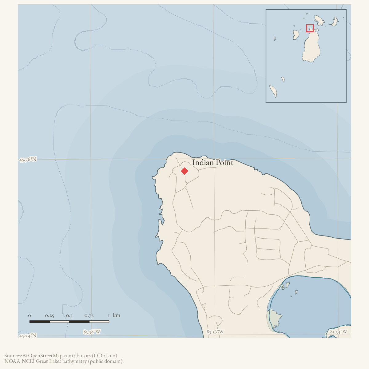
Indian Point is a cape on the northwest side of Beaver Island, about 4.6 km
by straight line from Saint James Harbor (EPSG:3078),
grouped in local reporting with Donegal Bay and
Font Lake.123 Held sources
document several distinct episodes there: a mission the Charlevoix Courier
in 1957 identified as the site of Beaver Island’s first Catholic church,
built in 1832 under Father Baraga’s guidance and later commemorated as
“Baraga’s Landing and chapel site”;45 the 1911
incorporation of a namesake timber company;6 the 1960 grounding
of a Manistique fishing tug, independently named in the Charlevoix Courier
as the F. Hunter;7 a 1967 land-development boom that
drew a reported 13,000 inquiries;8 and a destructive whirlwind
that struck the point first on 5 October 1997.9 confidence: probable reflects that several of these threads — the church site’s
present condition, the tug’s identity beyond its name, the point’s role in
1970s ice travel — rest on newspaper accounts not independently confirmed
by a survey or official record.
Geography
GNIS places Indian Point at 45.7586093° N, 85.5648109° W, on the “Garden Island West” quadrangle, roughly 4.6 km by straight line from the Saint James Harbor GNIS point (EPSG:3078).12 Multiple independent sources place it specifically on the island’s northwest side: the 1957 Charlevoix Courier locates the 1832 mission “on Indian point on the northwest section of the island”;4 the March and April 1960 Beacon and Courier storm reports both describe a tug driven aground “off the northwest part” or “on the northwest side” of the island;107 and 21st-century real-estate notices in the Beacon repeatedly describe rental cottages “near Indian Point (NW side).”1 A 1967 Beacon report groups Indian Point with Donegal Bay and Font Lake as the area American Central Land Development Corp. was subdividing, and a corroborating 1967 Charlevoix Courier account states the company’s offered land “extends north to Indian Point” from the eastern side of Font Lake.38 In February 1970, a five-person snowmobile party used Indian Point as its departure point for an ice crossing to Whiskey Island, about four miles away, before continuing toward Squaw Island (present-day Ojibwa Island) and Garden Island — evidence the point served as a staging point for inter-island winter travel, not a description of the point’s own extent.11 A separate 1915 reminiscence by Helen Hoffman Collar places her own family’s cottage on the “North, or Back Beach,” at the “narrowest place between the Harbor and Lake Michigan” — a different location roughly 4.6 km from Indian Point, and not to be confused with it, even though the same account places Father Hays’s house directly on Indian Point.12 A 1996 tribute after Collar’s death recalls her family walking “across Indian Point and down the old ties littering the abandoned railroad” to reach Pisgah Bay — the former name of Donegal Bay — placing the point on a foot route between Saint James and the bay.13
Baraga’s mission and chapel site
The fullest account of Indian Point’s role in the island’s Catholic history comes from a 1957 Charlevoix Courier article on the planned relocation of Holy Cross Church. Reporting pastor Fr. Joseph Herp’s account that Holy Cross was “the third Catholic church on Beaver Island,” the article states: “The first church was a crude structure of logs, hides and birch bark constructed by the Indians on Indian point on the northwest section of the island in 1832 under the guidance of Father Baraga, who later became the Bishop of Marquette… Nothing is known of the fate of the Catholic church during the years of Mormon occupation.”4 This gives a specific location — Indian Point — for the 1832 mission visit that Anishinaabe presence in the archipelago already documents from a separate, undated 1895 secondary account (Verwyst’s Life of Bishop Baraga, printed in Michigan Historical Collections vol. 26): a village of eight bark huts, a council, and 22 baptisms on 11 May of that year.14 The two accounts are independent and consistent in year and missionary; neither identifies who lived at the site before or names any individual present beyond Baraga.
A 1964 Beacon Homecoming report adds that the island’s annual Homecoming began in 1932 as a centennial celebration “in honor of Father Baraga’s Church on Indian Point,” and that the first church’s site was marked, as of 1964, by a large cross.15 Nearly three decades later, in March 1992, the Beaver Island Historical Society asked the Township Board to support a preservation grant “to acquire and preserve the Lighthouse on Squaw Island and Baraga’s Landing and chapel site on Indian Point on Beaver Island,” and the board passed a motion of support.5 This 1992 request is independent corroboration, using the specific term “Baraga’s Landing,” that a chapel site at Indian Point was still recognized and considered worth preserving 35 years after the 1957 account and 60 years after the 1932 centennial — but no source held here confirms whether the acquisition or preservation went forward, gives the site’s present physical condition, or supplies coordinates more precise than “on Indian point.”
What the sources do and do not support. The held sources document, consistently and from independent settler-press and community accounts, that Anishinaabe people built and used a mission structure at Indian Point in 1832 under Baraga’s guidance, and that a burial or cross-marked memorial site there was still known and valued by the local historical society as of 1992. They do not identify which Anishinaabe community or individuals were present, do not establish any present-day tribal ownership, stewardship, or consultation status for the site, and do not establish why the point carries the English name “Indian Point” — that name is not explained by any source held here, and this article does not infer a connection between the name and the 1832 mission or any other Anishinaabe association. A separate 1893 Charlevoix Sentinel item, in period settler-press language, reports that a young Anishinaabe traveler named in the press as “Kenwa’kenkezer,” journeying from St. James to his home on High Island, “was found frozen to death near Indian point” — a documented death during inter-island travel, not evidence about the mission site or the place name.16 Following the standard set in Anishinaabe presence in the archipelago, this article gives no coordinates, extent, or inventory for the chapel or any burial site beyond what the sources themselves state, and points any question about protection or access to the Little Traverse Bay Bands of Odawa Indians’ Tribal Historic Preservation Office rather than to this archive.
The 1960 tug grounding
On 20 March 1960, a 40-foot fishing tug from Manistique, crewed by three men, sought shelter off the island’s northwest side during a storm with winds up to 40 miles per hour and went aground at Indian Point; the crew walked to Saint James, and Coast Guard vessels — a Charlevoix picket boat, replaced by the cutter Sundew when ice blocked the smaller craft — assisted before all three boats spent the night at Saint James.10 The April 1960 Beacon account does not name the tug. An independent Charlevoix Courier report published four days after the storm does: “the 36 ft. lifeboat from the Charlevoix Lifeboat station was dispatched Wednesday morning to the assistance of the 40 ft. fish tug, F. Hunter, out of Manistique which went aground on Indian Point on the northwest side of Beaver Island in Monday night’s storm,” per Ch. Bosn W3 Albert Bates.7 A follow-up the next week adds that the tug Hunter “brought the C. G. C. Sundew into St. James Harbor,” and places the grounding “on the beach between Pagitown and Indian Point” — a second place name, “Pagitown,” not otherwise catalogued and not located here.17 This finding is recorded in this article because it bears directly on Indian Point’s own history; correcting the vessel’s name in Unnamed 40-foot Manistique fishing tug and Grounding of an unnamed Manistique fishing tug at Indian Point, 1960 themselves is outside this article’s lane.
Development, industry, and a 1997 storm
Indian Point’s commercial history includes an early-20th-century timber venture: a January 1911 Charlevoix Courier “St. James” correspondence item reports “the Indian Point Wood company is the name of the new corporation under the management of Oscar Martin,” with no further detail on its scale or duration.6 More than half a century later, the point was swept into the island’s largest land-development episode: an August 1967 Beacon report, “Donegal Face Lifting,” describes American Central Land Development Corp. building “miles of broad new roads” through the Donegal Bay, Font Lake, and Indian Point area, met with “mixed emotions” by residents familiar with it.3 A corroborating May 1967 Charlevoix Courier account gives figures the Beacon does not: more than $50,000 in property changed hands the weekend of 20-21 May 1967, the land had been purchased from Henry Allen, and the company “reportedly has received 13,000 inquiries about the property,” which “extends north to Indian Point” from Font Lake’s eastern side.8 Indian Point Road, radiating from this development, appears repeatedly in later Beacon classifieds and township records as a named, maintained road.1
On 5 October 1997, an unusual whirlwind — variously called a tornado or waterspout in the Beacon’s own account — struck the island in a narrow path “from Indian Point to the Harbor.” First noticed as waterspouts approaching the northwest corner, the wind hit Indian Point “like the ‘Grim Reaper,’” downing large trees on several properties within seconds before continuing on to damage the St. James Campground and the Village. No serious injuries were reported.9
What was rejected
An October 1962 Beacon notice, “Attention Coyote Hunters!!,” names “Roy
Chambers and Roy Vincent of Indian River” bringing coyote hounds to the
island. A prior pass linked this event (event/beaver-island-coyote-hunt-october-1962)
to Indian Point in its frontmatter related_to, but the source text names
Indian River, Michigan — a mainland town, not Indian Point on Beaver
Island. That relation is a homonym error in a satellite article outside
this article’s lane; it is not repeated or relied on here.
Open questions
- What is the present physical condition of the 1832 mission/chapel site and the large cross recorded there in 1964, and did the 1992 preservation grant request succeed?
- Which Anishinaabe community or individuals were present at Indian Point in 1832, and does any tribal record — as opposed to settler-press or community-society accounts — describe the site?
- Where was “Pagitown,” named alongside Indian Point in the 1960 Charlevoix Courier grounding follow-up?
- How long did the Indian Point Wood Company (1911) operate, and what did it produce?
- Did the 13,000 inquiries reported in 1967 translate into completed lots, and how much of the Donegal Bay/Font Lake/Indian Point development was actually built out?
See also
Footnotes
-
USGS GNIS, Domestic Names (Michigan), feature 629013,
data/federal/gnis/gnis_names.geojson. ↩ ↩2 ↩3 ↩4 -
Distance computed between the GNIS points for Indian Point and Saint James Harbor, both reprojected to EPSG:3078 (Michigan GeoRef, metres). ↩ ↩2
-
Charlevoix Courier, Thursday, 7 November 1957, “Holy Cross Church to be Moved To New Site on Beaver Island.” ↩ ↩2 ↩3
-
Charlevoix Courier, January 1911, “St. James” correspondence column. ↩ ↩2
-
Charlevoix Courier, Thursday, 24 March 1960, storm report. ↩ ↩2 ↩3
-
Charlevoix Courier, May 1967, “Buyers Flock to Beaver.” ↩ ↩2 ↩3
-
Beaver Beacon, November 1997, “Whatever It Was, It Was Ba-a-ad!” ↩ ↩2
-
Beaver Beacon, February 1970, “Island Hopping.” ↩
-
Beaver Beacon, September 1964, “Know Your Neighbor,” Helen Hoffman Collar. ↩
-
Beaver Beacon, February 1996, “Appreciation” (obituary for Helen Hoffman Collar). ↩
-
Anishinaabe presence in the archipelago, citing Chrysostom Verwyst, “Life and Labors of Bishop Baraga,” Michigan Historical Collections, vol. 26 (1895), pp. 535-537. ↩
-
Beaver Beacon, August 1964, Homecoming report. ↩
-
Charlevoix Sentinel, 1 March 1893, “Northern Michigan News.” ↩
-
Charlevoix Courier, Thursday, 31 March 1960, follow-up report. ↩
Sources
- Described in this archive: Beaver Island History Map, 1978 revision.Labels Baraga's Landing, an early Indigenous settlement, and a “Lost Indian Burial Ground.” The chapel tradition is cross-checked below; the settlement's bounds and burial-ground location are not adopted from the map and require tribal as well as archival guidance.
- GNIS feature 629013; feature class 'Cape'; map 'Garden Island West'; date_created 14 April 1980 (Phase I compilation). No bgn_authority or bgn_date is recorded, and no variant-name row exists for this feature.federal · gnis · gnis_names
- No row for feature 629013 exists; GNIS records no spelling variant or superseded name for Indian Point, and no source held here attests one either.federal · gnis · gnis_variant_names
- Charlevoix Courier, Thursday, November 7, 1957, "Holy Cross Church to be Moved To New Site on Beaver Island."Read directly. Reports, per pastor Fr. Joseph Herp OFM, that Holy Cross Church "is the third Catholic church on Beaver Island," and that "the first church was a crude structure of logs, hides and birch bark constructed by the Indians on Indian point on the northwest section of the island in 1832 under the guidance of Father Baraga, who later became the Bishop of Marquette," adding that "nothing is known of the fate of the Catholic church during the years of Mormon occupation." This is the specific location held here for Baraga's 1832 mission, independent of and consistent with the undated 1832-visit account already used in theme/anishinaabe-presence (Verwyst 1895, via Michigan Historical Collections vol. 26). No public copy of this file is known; the archive holds one and can provide it on request.data1 · beaver-island-archive · charlevoix · charlevoixcourie0419unse
- States that the 1932 centennial celebration honored "Father Baraga's Church on Indian Point" and that the first church site was marked by a large cross at the time of the 1964 report.data1 · beaver-island-archive · beaver_beacon · 1964-08_Beaver-Beacon
- The held six-page issue scan is paired with the OCR source and confirms the published notice or report; it does not expand the source-specific identity, event, or outcome claims.data1 · beaver-island-archive · scans · beaver_beacon · issues · 1964-08_Beaver-Beacon
- Reports that the Beaver Island Historical Society asked the Township Board to write in support of a preservation grant "to acquire and preserve the Lighthouse on Squaw Island and Baraga's Landing and chapel site on Indian Point on Beaver Island," and that the board passed a motion of support. Independent, 28-years-later corroboration that a specific "Baraga's Landing and chapel site" at Indian Point was recognized as a preservation-worthy historic site by 1992; it does not itself give coordinates, a survey, or a present condition. The holding institution's portal restricts automated access; the archive holds a copy of this issue and can provide it on request.data1 · beaver-island-archive · beaver_beacon · 1992-03_Beaver-Beacon
- Charlevoix Sentinel, 1 March 1893, "Northern Michigan News."Read directly. Reports that mail carriers arriving at Cross Village with the Beaver Island mail on "Wednesday, 17th inst." said that Barney Martin, traveling from Cross Village to the Beavers, had his feet badly frozen, "also that a young Indian named Kenwa'kenkezer, who left St. James for his home on High Island was found frozen to death near Indian point." A settler-press report, in period orthography and without further identification; it documents a specific Anishinaabe traveler's death near this place while journeying between St. James and a documented Anishinaabe community on High Island. It is not evidence for the origin of the English place name "Indian Point," which this article does not infer from any of its Anishinaabe-related sources. No public copy of this file is known; the archive holds one and can provide it on request.data1 · beaver-island-archive · charlevoix · charlevoixsentin1217unse
- Charlevoix Courier, Thursday, March 24, 1960, storm report.Read directly. Reports that "the 36 ft. lifeboat from the Charlevoix Lifeboat station was dispatched Wednesday morning to the assistance of the 40 ft. fish tug, F. Hunter, out of Manistique which went aground on Indian Point on the northwest side of Beaver Island in Monday night's storm," per Ch. Bosn W3 Albert Bates. This independently names the vessel the April 1960 Beaver Beacon calls only "an unnamed 40-foot fishing tug" (see event/grounding-of-manistique-fishing-tug-at-indian-point-1960 and vessel/manistique-fishing-tug-1960, both out of this article's lane). No public copy of this file is known; the archive holds one and can provide it on request.data1 · beaver-island-archive · charlevoix · charlevoixcourie0317unse
- Charlevoix Courier, Thursday, March 31, 1960, follow-up report.Read directly. A second, following-week item says "the fish tug Hunter from Manistique which went aground last Monday night in the storm on the beach between Pagitown and Indian Point brought the C. G. C. Sundew into St. James Harbor." Names an additional place, "Pagitown," not otherwise catalogued; its location is not established here. No public copy of this file is known; the archive holds one and can provide it on request.data1 · beaver-island-archive · charlevoix · charlevoixcourie0317unse
- Reports that a 40-foot fishing tug sought shelter off the northwest part of Beaver Island and went aground at Indian Point during a March storm; the crew walked to St. James and the Coast Guard responded.data1 · beaver-island-archive · beaver_beacon · 1960-04_Beaver-Beacon
- The held four-page issue scan is paired with the OCR source and confirms the published notice or report; it does not expand the source-specific identity, event, or outcome claims.data1 · beaver-island-archive · scans · beaver_beacon · issues · 1960-04_Beaver-Beacon
- Charlevoix Courier, January 1911, "St. James" correspondence column.Read directly (issue batch dated Jan. 11-14, 1911). Reports "The Indian Point Wood company is the name of the new corporation under the management of Oscar Martin" — a named early-20th-century timber corporation taking its name from the point. No further detail on its operations, duration, or output is given here. No public copy of this file is known; the archive holds one and can provide it on request.data1 · beaver-island-archive · charlevoix · charlevoixcourie0111unse
- A 1915 reminiscence by Helen Hoffman Collar places Father Hays's house on Indian Point and describes Garden Island residents anchoring off Beaver Island's North or Back Beach and portaging supplies to town. Her own family's 1916 cottage was nearby, at the "narrowest place between the Harbor and Lake Michigan" — a separate location from Indian Point itself, roughly 4.6 km away by straight line from the GNIS point (EPSG:3078).data1 · beaver-island-archive · beaver_beacon · 1964-09_Beaver-Beacon
- The held eight-page issue scan is paired with the OCR source and confirms the published notice or report; it does not expand the source-specific identity, event, or outcome claims.data1 · beaver-island-archive · scans · beaver_beacon · issues · 1964-09_Beaver-Beacon
- Read directly. A grandson's tribute, printed after Collar's death on 9 January 1996, recalls her family "hik[ing] across Indian Point and down the old ties littering the abandoned railroad, to Pisgah Bay" on moonlit nights to picnic on Mount Pisgah — placing Indian Point on the route between Saint James and the former Pisgah Bay (renamed Donegal Bay), and noting Collar's insistence that "there was no Donegal Bay Road then... to Helen there never was a 'Donegal Bay.'" The holding institution's portal restricts automated access; the archive holds a copy of this issue and can provide it on request.data1 · beaver-island-archive · beaver_beacon · 1996-02_Beaver-Beacon
- Reports new roads and property sales around Donegal Bay, Font Lake, and Indian Point by American Central Land Development Corp.; it records the reported transition and mixed local reactions, not completed development.data1 · beaver-island-archive · beaver_beacon · 1967-08_Beaver-Beacon
- The held six-page issue scan is paired with the OCR source and confirms the published notice or report; it does not expand the source-specific identity, event, or outcome claims.data1 · beaver-island-archive · scans · beaver_beacon · issues · 1967-08_Beaver-Beacon
- Charlevoix Courier, May 1967, "Buyers Flock to Beaver."Read directly. Reports more than $50,000 in Beaver Island property changing hands the weekend of 20-21 May 1967 as American Central Land Co. of Lansing subdivided land purchased from Henry Allen for resort development; "the property for sale on the island lies between the western shore of the island and the eastern side of Font Lake. It extends north to Indian Point. American Central reportedly has received 13,000 inquiries about the property." Independent corroboration, with added figures, of the same land-development episode the August 1967 Beacon calls "Donegal Face Lifting." No public copy of this file is known; the archive holds one and can provide it on request.data1 · beaver-island-archive · charlevoix · charlevoixcourie1967unse
- Describes a five-person snowmobile party departing Indian Point for Whiskey Island over ice measured at more than ten inches, then continuing toward Squaw and Garden Islands; the account emphasizes currents, wind, and changing ice conditions.data1 · beaver-island-archive · beaver_beacon · 1970-02_Beaver-Beacon
- The held eleven-page issue scan is paired with the OCR source and confirms the published notice or report; it does not expand the source-specific identity, event, or outcome claims.data1 · beaver-island-archive · scans · beaver_beacon · issues · 1970-02_Beaver-Beacon
- Read directly. Describes a whirlwind (waterspout/possible tornado) that struck the island on 5 October 1997, first observed by Jim Wojan at the northwest corner, hitting Indian Point first — "downing large trees on several properties in only a matter of seconds" — before crossing to the St. James Campground and the Village. No serious injuries were reported. The holding institution's portal restricts automated access; the archive holds a copy of this issue and can provide it on request.data1 · beaver-island-archive · beaver_beacon · 1997-11_Beaver-Beacon
- The held issue scan confirms the October 5 whirlwind report at Indian Point.data1 · beaver-island-archive · scans · beaver_beacon · issues · 1997-11_Beaver-Beacon
Added 28 July 2026 · revised 4 August 2026. Recent changes
Cite this article
Beaver Island Archive, “Indian Point”, https://beaverislandarchive.org/places/indian-point/, accessed [date], citing Beaver Island Historical Society, *Beaver Island Historical Map* (1978 revision). (and 22 further sources listed on the page).
Last revised 2026-08-04. Fill in [date] with the date you read it — this page is static and cannot know that.