

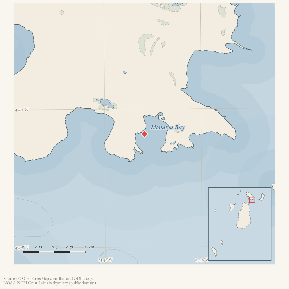
- Coordinates
- 45.7764° N, 85.4718° WGoogle Maps: Monatou BayDownload KML
- Concepts
- fishingtourismmaritimeenvironmentgeologysoilswetlandshydrologyvegetationplantstreeswildlifeanimalsconservationstewardshipinvasive-species
- Within
- Garden Island
Summary
Monatou Bay is a named bay at Garden Island. A June 1970 Beaver Beacon fishing report calls it a favorite spot for experienced and well-equipped fishermen and associates it with successful perch catches. The report is local recreational evidence rather than a survey of the bay’s fishery, and its OCR contains an ambiguous word immediately before the place name that is not treated as a variant of “Monatou.”
Ecological profile
MNFI Report 2017-11 records the 37-acre Northcutt and Monatou Bays coastal fen (EO 10574, rank AB, G1G2/S2) on Garden Island. The fen grades into Great Lakes marsh and limestone cobble shore, and its margins shift with Great Lakes water level fluctuations. The Monatou portion has alkaline gravelly marl around pH 8.0 and numerous marl pools. It includes tufted bulrush, sedge, twig-rush, pitcher plant, false asphodel, grass-of-Parnassus, bird’s-eye primrose, hardstem bulrush, bog goldenrod, Indian paintbrush, shrubby cinquefoil, cedar, and tamarack. MNFI describes it as suitable habitat for Hine’s emerald dragonfly, a state and federally threatened species, but does not confirm a population.
The Northcutt portion has shallow 8–10-centimeter organics over alkaline sands around pH 8.0 and wraps a large marl pond. The report separately identifies a 156-acre Monatou Bay limestone cobble shore (EO 20448, rank A, G2G3/S3; report p. 77), described as the only A-ranked limestone cobble shore in Michigan in the report. Alkaline wet gravelly sands and organic material occur between and beneath cobbles and boulders. Waves, seiches, storm surges, and longer lake-level cycles rework the shore; driftwood and plant debris provide insect and herptile habitat and contribute organic matter. The sparse shore vegetation includes northern white-cedar, willows, paper birch, Baltic rush, Ohio goldenrod, blue-joint, limestone calamint, mountain blue-eyed grass, and panic grass.
MNFI observed no threats in these records and recommends natural Great Lakes processes, buffers, and invasive-plant monitoring. These are source-defined historical ecological occurrences, not a current legal boundary, property or ownership determination, shoreline condition assessment, dragonfly census, or complete survey of Monatou Bay, Northcutt Bay, or Garden Island.
Open questions
- Can historical charts or Garden Island management records document the bay’s shoreline, access, and relationship to nearby named harbors?
- Are the 1970 perch observations part of a longer local fishery record?
- How do the MNFI occurrence polygons relate to the GNIS point, current shoreline, land status, and the adjacent Northcutt Bay occurrence?
Maps for this place
These Atlas plates provide regional context. They do not establish a precise boundary, current ownership, access right, operating status, or field condition.
- EnvironmentSoils, wetlands, hydrography, and terrain
- GeologyGeneralized geology and landforms
- HydrologyMapped water and wetland context
- AccessMapped routes, facilities, and protected areas
Sources
- GNIS feature 632564; feature class 'Bay'.federal · gnis · gnis_names
- Calls Monatou Bay at Garden Island a favorite spot for experienced fishermen and reports good perch catches there; the OCR includes an ambiguous preceding “Pete” that is not interpreted as part of the place name.data1 · beaver-island-archive · beaver_beacon · 1970-06_Beaver-Beacon
- The held ten-page issue scan is paired with the OCR source and confirms the published notice or report; it does not expand the source-specific identity, event, or outcome claims.data1 · beaver-island-archive · scans · beaver_beacon · issues · 1970-06_Beaver-Beacon
- Project-generated MNFI 2017 soil, vegetation, and wildlife crosswalk, preserving MNFI Report 2017-11, Northcutt and Monatou Bays coastal fen (EO 10574), report p. 41.The 37-acre occurrence spans named Northcutt and Monatou Bays; it is a natural-community record, not a current legal boundary, ownership determination, or complete survey. No public copy of this file is known; the archive holds one and can provide it on request.research · island_farming · crosswalks · mnfi_soil_vegetation_wildlife_crosswalk
- Visual page evidence held with provenance sidecar; the image anchors the named occurrence and does not establish modern geometry or current condition.research · island_farming · evidence · mnfi-report-2017-11-page-0041-northcutt-monatou-bays-coastal-fen
- Visual page evidence held with provenance sidecar; the image anchors the named occurrence and does not establish modern geometry or current condition.research · island_farming · evidence · mnfi-report-2017-11-page-0077-monatou-bay-limestone-cobble-shore
Added 28 July 2026 · revised 3 August 2026. Recent changes
Cite this article
Beaver Island Archive, “Monatou Bay”, https://beaverislandarchive.org/places/monatou-bay/, accessed [date], citing U.S. Geological Survey, Geographic Names Information System, Domestic Names (Michigan), retrieved 2026-07-28. (and 5 further sources listed on the page).
Last revised 2026-08-03. Fill in [date] with the date you read it — this page is static and cannot know that.