

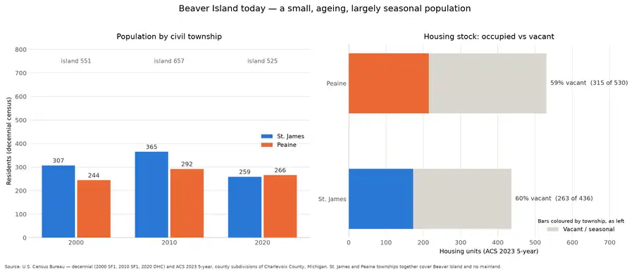
The demographic series for the island townships. The 1850 census excluded Anishinaabe people, so every series here begins by omitting the longest-resident population.
Visual descriptionwritten by a machine · unchecked
A wide, two-panel statistical infographic on a white background. The left panel uses blue and orange vertical bars to compare population across three years, with township and total labels; the right panel uses horizontal stacked bars to compare occupied and vacant housing units. Axes, legends, percentages, counts, and a source note appear throughout the graphic.
A model wrote this. It was shown the image and the catalogue record together, and asked to keep them apart — what it saw is here, what the record told it is under "taken from the record" below. It is still wrong often enough to matter, about who is pictured, where, when, and what is happening. Read it as a way to find the image, never as evidence about it. If you can correct it, please do: write to michael.bommarito@gmail.com, or see how corrections work. Someone who recognises a face or a shoreline knows more than the model did.
Drawn from U.S. Census Bureau decennial and ACS series (public domain).
2,621 × 1,136 px · PNG · 148 KB
Subjects and keywords
Text in the image
Transcribed from the object itself.
Beaver Island today — a small, ageing, largely seasonal population
Population by civil township
Housing stock: occupied vs vacant
Residents (decennial census)
Housing units (ACS 2023 5-year)
Year
2000
2010
2020
St. James
Peaine
island 551
island 657
island 525
307
244
365
292
259
266
59% vacant (315 of 530)
60% vacant (263 of 436)
Vacant / seasonal
Source: U.S. Census Bureau — decennial (2000 SF1, 2010 SF1, 2020 DHC) and ACS 2023 5-year, county subdivisions of Charlevoix County, Michigan. St. James and Peaine townships together cover Beaver Island and no mainland.
Taken from the record
Not observed in the image — supplied by the archive's own catalogue, and repeated here so the two stay distinguishable.
The archive catalogues this as a plate in the Thematic plates collection, drawn from U.S. Census Bureau decennial and ACS series. The underlying data are recorded as public domain, and the chart as CC BY 4.0. The archive description notes that the 1850 census excluded Anishinaabe people.
Rights and credit
CC BY 4.0 for the chart; underlying data public domain (U.S. Census Bureau)
Credit this to Drawn from U.S. Census Bureau decennial and ACS series (public domain). when you use it.
Stated by this archive, which drew the plate.
Provenance
- Held by
- Beaver Island Archive
- Collection
- Thematic plates
- Drawn by
- scripts/make_atlas.py
- Title from
- this archive, which drew the plate
The file
| Rendition | Format | Extent | Size | SHA-256 |
|---|---|---|---|---|
| Master | PNG | 2,621 × 1,136 px | 148 KB | 29cd76f755ec… |
Checksums are the values recorded when each copy was taken, or computed from the bytes held where the retrieval recorded no checksum for that particular file.
Download
- Web-sized image900 × 390 · 14 KB · WebP
Cite this
“Population and housing”. Beaver Island Archive. Beaver Island Archive, https://beaverislandarchive.org/media/plate/population-and-housing/.
Built only from what the archive recorded: the names on the record, the title as recorded, the date if one was recorded, this page, and the date the copy was taken. Nothing is filled in to satisfy a citation style.