

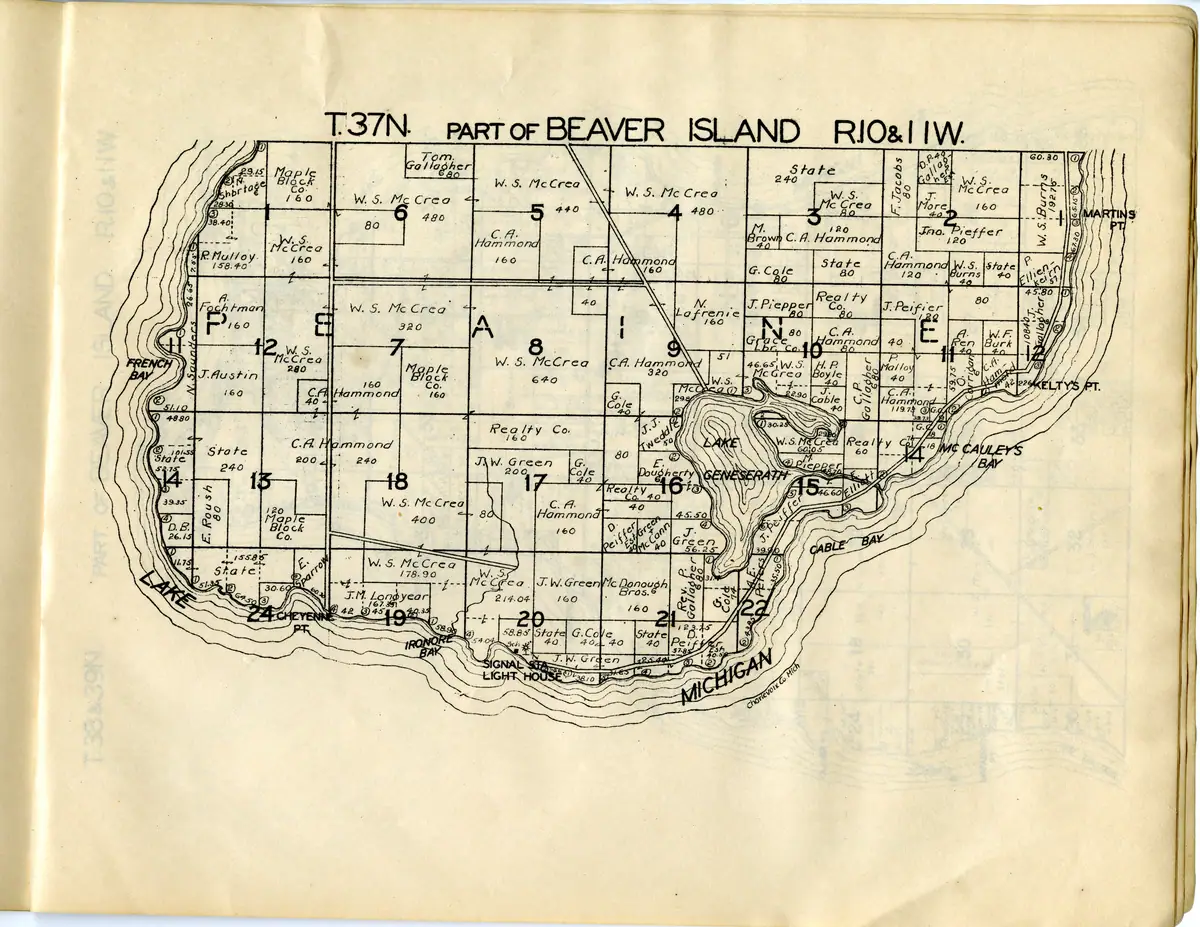
Plat of the south end of Beaver Island, second Hixson printing. The southern third of Beaver Island in the second W. W. Hixson printing MSU holds, dated by the repository to a wider range than the other copy: Peaine township south of the township line, from French Bay and Cheyenne Point round to Cable Bay and Martin's Point, with Lake Geneserath at its centre. Sheet heading as printed: T.37N. PART OF BEAVER ISLAND R.10&11W. Canvas 12 of 16 in the IIIF manifest for Michigan State University Digital Repository item 113, held separately by that repository as item 125 (https://n2t.net/ark:/85335/m5jw8bp2z); the same leaf is page 14 of the volume PDF, verified against that page's own printed heading. The atlas prints no leaf numbers, so canvas position and PDF page are the only two numberings it has. Source: W. W. Hixson & Co., Rockford, Illinois, Plat Book of Charlevoix Co. Mich., between 1929 and 1955 — the repository gives a range, not a year.
Michigan State University Libraries, Digital Repository
6,600 × 5,100 px · JPEG · 12.5 MB
Rights and credit
Public domain — Michigan State University Libraries records this atlas as 'No Copyright', on the ground that it was 'Published in the United States before 1978 without a copyright notice', and its IIIF manifest carries the Creative Commons Public Domain Mark 1.0.
Credit this to Michigan State University Libraries, Digital Repository when you use it.
Material goes off the web without anyone deciding that it should: a host lapses, a gallery is retired, a link stops resolving. Holding a copy — with its provenance, its checksum and its holder's terms recorded beside it — is much of why this archive exists. If you are looking for something whose original has since gone, write to michael.bommarito@gmail.com and a full-size copy of what is held here will be sent to you.
Recorded verbatim from the provenance sidecar taken at retrieval — this archive does not restate a holder's terms in its own words, does not add a restriction the holder did not state, and does not abridge one.
Provenance
- Held by
- Michigan State University Libraries, Digital Repository
- Collection
- Plat book of Charlevoix County, Michigan, second Hixson copy — archipelago sheets
- Original
- https://d.lib.msu.edu/iiif/maps:125/full/max/0/default.jpg
- Copy taken
- 2026-08-06
- Title from
- the note recorded at retrieval
The file
| Rendition | Format | Extent | Size | SHA-256 |
|---|---|---|---|---|
| Master | JPEG | 6,600 × 5,100 px | 12.5 MB | 3a8f7e773631… |
Checksums are the values recorded when each copy was taken.
Download
- Web-sized image1200 × 927 · 130 KB · WebP
- The full-resolution original, from Michigan State University Libraries, Digital Repository6,600 × 5,100 · 12.5 MB · JPEG

The archive holds its own copy of that file and will supply it on request; it is not re-served here, because the holder serves it better and a second copy is a second thing to go stale.
Deep zoom
This sheet is published as a IIIF Image API 3.0 Level 0 service: a pre-generated pyramid of static tiles, served as plain files with no image server behind them. The viewer above reads it, and so will any IIIF viewer you point at the service description.
Because it is IIIF rather than a private tile format, tools outside this archive can use it too — including Allmaps, which can georeference a historical sheet from exactly this service and lay it over a modern map.
- Service description (
info.json)6,600 × 5,100 px · 5 zoom levels · 512 px tiles
Cite this
“Plat of the south end of Beaver Island, second Hixson printing”. Michigan State University Libraries, Digital Repository. Beaver Island Archive, https://beaverislandarchive.org/media/map/south-beaver-island-plat-1929-1955/. copy retrieved 2026-08-06.
Built only from what the archive recorded: the names on the record, the title as recorded, the date if one was recorded, this page, and the date the copy was taken. Nothing is filled in to satisfy a citation style.